• For 2024 Pilgrims: €50,- donation = 1 year with no ads on the forum + 90% off any 2024 Guide. More here.
    (Discount code sent to you by Private Message after your donation)
  • ⚠️ Emergency contact in Spain - Dial 112 and AlertCops app. More on this here.

Search 69,459 Camino Questions

Paris to SJPDP

D

Deleted member 397

Guest
I'm thinking of doing this route next year.It's obviously not as popular as others given the paucity of posts but I'm wondering whether anyone has any experience in using either the Francois Lepere or the Rando guides. Both are obviously in French so I wanted to wade through one of them with dictionary in hand well before I go. The CSJ Marigold Fox is another possibility but would involve a lot of cut and paste with all the updates.
 
Technical backpack for day trips with backpack cover and internal compartment for the hydration bladder. Ideal daypack for excursions where we need a medium capacity backpack. The back with Air Flow System creates large air channels that will keep our back as cool as possible.

€83,-
Hi, I have in my hand the Topo guide (ref 6552) for the Paris route via Tours. I have yet to study it in great detail (a friend and I are tentatively walking this path in 2010 to mark our special birthdays) but the copy I have here only goes from Tours, Poitiers, Saintes, Mirambeau. I also have the 2006 edition of the book "Le Chemin de paris et de Tours" Jean-Yves Gregoire - Jaqueline Veron (Rando editions). This book takes you from Paris, Etamps, Orleans, Tours and then down to Bordeaux and on to Bayonne, where it stops. This book then joins up with the another which follows the Camino del Norte. However, there is another book (which I don't have) showing a path from Bayonne to St Jean I think (or there is a Topo guide from Irun to St Jean going through the lower Pyrennnees).

The Topo guides have much better maps, but obviously it is only part of the path. I used the equivalent Rando guide from Le Puy, and despite the fact that it was the latest edition there were a lot of things out of date / incorrect in it. I used the maps only, which are a strip map style, but much more info than the Raju Cicerone Guide, but not as much as the relevant Topo guides.

I also own a book by a NSW woman who walked from Paris. This book is a little old now, and it is written in a "I did this, then I did that" style, with little lists of what and where she stayed, ate etc. It is out on loan at present, but will try and get the name and contact details of the woman concerned and PM you with it. I rang her and quite a chat last year.

Hope that is of some help. Janet
 
Janet
Thanks for the info.Shame about the Rando guide being not the best as at least it goes from Paris. I have the Mary Wilkie too and found it a good read but as you say more a personal account than a guide.If you are doing the Paris-SJPDP route you might be interested in ultreia books which have 14 books for the camino. They are at http://www.chemin-compostelle.fr/boutique.htm
Have to decide soon as I want to translate whichever one I get.
 
Very light, comfortable and compressible poncho. Specially designed for protection against water for any activity.

Our Atmospheric H30 poncho offers lightness and waterproofness. Easily compressible and made with our Waterproof fabric, its heat-sealed interior seams guarantee its waterproofness. Includes carrying bag.

€60,-
I have a copy of the Lepere guide book (ultreia books) for Vezelay (am not going to use it though as I will use the one from CSJ). Of the Topo guide, the Rando guide and the Lepere guide though, I think the maps in the Lepere guide, combined with the path they take, is perhaps the best option after the CSJ. I would think, using that premise, that the same would apply to the paris guide book too, and I would think that is perhaps likely what I would use. They seem to update the more common ones reasonably regularly. Cheers, Janet
 
In 2004 I walked the Via Turonensis using the following guides, websites and books for reference:

1. Paris City Guide and Paris to the Pyrenees. Available from the CSJ-UK. http://www.csj.org.uk
2. cranleigh@northnet.com.au Mary Wilkie’s Book "Walking to Santiago"
3. http://www.philippe@doph.net Philippe Du Ngoc

The routes is almost completely FLAT until you reach the south. Much of the route follows tarmac roads. We asked locals to direct us to smaller roads and this often meant much longer days walking.
There are practically no pilgrim refuges until you reach Ostabat with the exception of Saintes and St Martin's just before Blaye.
It is also a very lonely route with few pilgrims until you reach St Palais and St Jean.
 
Thanks Sil
As I mentioned in my post I've got the Wilkie book and thought that the Fox book might be a bit out of date as it was written 10 years ago and the latest updates are from 2005.JL recommended the Lepere book but advised that I should wait as a new edition might be coming out. The Ultreia publications seem to be pretty comprehensive in the routes they cover. Shame about no albergues but you say it is lonely with few pilgrims-sounds perfect!
 
3rd Edition. More content, training & pack guides avoid common mistakes, bed bugs etc
Omar, I'm sure some things have changed in the last 4 years, although reading Gareth's blog it doesn't sound as though much has changed.
Because there are virtually no 'wilderness' area you walk on lots of district roads through villages, towns, cities etc., I felt more like a tourist with a backpack than a hiker or a pilgrim.
Mary Wilkie (from Australia) also described the busy roads with heavy traffic almost wiping you out.
The flat, busy, built up road makes it a not very romantic route and that probably explains why it is not very popular.
 
Doesn;t sound very appealing! I might have to go to plan B-which is from Vezelay. I liked the route from le puy in 2007 and was looking for another long distance walk-airfares from Australia for next may have gone up about 20%! so thought I may as well make the most of being away.
Whichever way I go I intend to turn right at SJPDP to continue along the northern route-that too has quite a lot of road walking but at least it's not the CF. For French readers the books offered on http://www.chemin-compostelle.fr seem like a good optionthey have 25 books covering routes in France and Spain. Thanks everyone for contributions.
 
Hi Omar,

Just changed my plans last night, as I am planning the Vezelay route next year and intended to catch a train out to Bayonne when I got to St Jean. After some research I have found there are a couple of alternatives - in that it really isn't that far to walk. One option I am pursuing at present is to "turn right" at St Jean and follow the GR10 to Hendaye. There is a very good little Cicerone guide (in English) detailing the path, and although there are some steep parts, none of it would be much worse I don't think than parts of the Le Puy stretch we both did last year. The Cicerone guide though takes it from Hendaye, rather than too, and so the walking would be done "backwards". From what I could gather from my research last night (on line) there are just a couple of little bits where there are safety warnings, and I think that it would be safe enough weahter wise in late September when I am planning to be there. Of course, if the weather is in doubt, I would treat it the same as we do when walking in the alps in NZ or Tassie.

I gleaned, I think, that there is adequate accomodation along the way (gites and hotels - so you don't need a tent) and food is reasonably available - one place even having a supermarket. The elevations don't seem to be any higher than the Aubrac Plateau.

I think I also noticed a Lepere book walking from St Jean out to Bayonne. I don't know how many days that would be, but the GR10 is 5 stages - all af about 20 - 25kms.

Looking on the raod map book of France that I have I also see the Chemin St Jacques marked from St Jean to Bayonne and it appears to be following the river. If that were the case one could fair "motor" down there after walking 850kms from Vezelay. I will keep you posted on anything else that I find and if wnayone has any advise on the GR10 it would be appreciated.

Who knows, we might be on the path around the same time.

Cheers, Janet
 
The one from Galicia (the round) and the one from Castilla & Leon. Individually numbered and made by the same people that make the ones you see on your walk.
The main road between Paris and Spain probably hasn't changed direction for a thousand years! The old highway used by travellers, merchants, pilgrims and soldiers was the obvious route to tar and became the main autoroute. This means that one has to follow department roads on either side of the main highway and these too can be very busy.
Besides a few youth hostels, there were not many gites between Paris and Bordeaux. We stayed in an assortment of accommodations including Formule1 hotels that were quite cheap for double rooms and included breakfast.
I have posted this profile map of the route - I wish I find the original size now - but there are a few maps on the link below. You can see that it is almost a flat-line until you reach the Landes.

The other map is a general route map from Paris to Spain.

http://pagesperso-orange.fr/viaturonensis/cartes
 

Attachments

  • ParistoRoncesvalles.jpg
    ParistoRoncesvalles.jpg
    53.4 KB · Views: 1,893
  • Via Touronensis profile.JPG
    Via Touronensis profile.JPG
    5.9 KB · Views: 1,887
sillydoll said:
I'm sure some things have changed in the last 4 years, although reading Gareth's blog it doesn't sound as though much has changed

I've just caught up with this discussion. Having walked the Turonensis during my Worcester-Santiago walk, picking it up from Tours and following the whole route to SJPP, I am familiar with every inch of the way in the wettest May since records began! I would highly recommend the route from Tours to Mirambeau, where quite a lot of the GR route follows off-road paths. It is after Blaye that you have mostly difficult road walking, and to be honest, I would never do it again!

Gareth
 
26th May 2004:
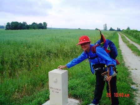
The lady in the Tourist office told us not to walk on the N137 to Mirambeau as it was not safe. She said to rather take the Chemin St Jacques trail which is very well marked with scallop shells on concrete 'steles' along the way. 'It is only 25kms' she told us.
The first stele we came across after walking about 2km out of town said '31Kms' to Mirambeau and pointed straight onto a path between a wheat field and a vineyard. So we climbed through head high vegetation, grass so high that we had to frog march with high knees to get through, wobble along stony paths through vineyards and past farmer's barns and through a Stainbank-like forest.
Then we were sent through hard, lumpy recently ploughed ground, through field after field. Not one person, no villages, no signs, no shops, just ploughed fields. 33kms to Mirambeau. We were pooped when we finally arrived at about 3.30pm and for the first time were both GAT VOL of Chemin signs and fields!
 

Attachments

  • 17 to Mirambeau.JPG
    17 to Mirambeau.JPG
    154.2 KB · Views: 1,668
St James' Way - Self-guided 4-7 day Walking Packages, Reading to Southampton, 110 kms
Gareth - I couldn't remember walking on busy roads in the south and your post made me read my 2004 diary again for the first time in a long while.

Here are a few extracts:

Blaye to Le Barp:
It was 29kms to Le Barp walking on small suburban roads instead of following the district road.

To La Muret:
The fellow at the hotel said that we could walk all the way to Le Muret on the ‘la petit’ road so we took his advice and followed the smaller roads on the edge of a forest.

To Labouheyre:
Following the smaller roads meant that we walked 32kms instead of 25km – what’s new?

To Rion-des-Landes:
We pushed on to Rion-des-Landes on a quiet tarred road, and on a loggers' path, through never ending forests of pine trees.

To Dax:
We ended up walking all the way through the forests to the within 6kms of Dax. Stopped at St Vincent de Paul where a charming nun tried to persuade us to stop over for the night.

(We caught a train from Dax to Lourdes. Spent the day there and then got the train to Peyrehorade where we walked 15km to Bidache).

To St Palais
The 28kms to St Palais the was VERY HOT - in the 30´s - and hilly

To Larceveau:
We found our way onto the right road and immediately started to climb a long gentle slope. The terrain became undulating and some of the hills were quite steep.

St Jean Pied De Port:
The next day we walked to St Jean Pied de Port – hot, hot, hot - where we saw lots of other pilgrims for the first time.
 
sillydoll said:
Blaye to Le Barp: It was 29kms to Le Barp walking on small suburban roads instead of following the district road.

Sorry to disagree, Sil, but that's not a one day 29 km walk: it's about 80 or 90 km from Blaye to Le Barp - three days walk including going through the major urban area of Bordeaux, preceded by roads filled with lorries in the Medoc region (after crossing over the Gironde from Blaye) and then there are busy roads on the way out of the city as well, long before you get to the quieter roads you mention, which I also experienced - but sandwiched between unpleasant busy roads, which is why I don't recommend this route. If there's a way of doing this entirely avoiding busy roads, the Amis de StJacques in Bordeaux could benefit from your knowledge, as they didn't seem to know of an alternative when I spoke with them.

There are indeed forest routes and various bits of the Chemin St Jacques south of Bordeaux that are quite pleasant; but my experience is that these are sandwiched between some pretty unpleasant stretches of busy and sometimes dangerous tarmac. If this can be avoided, it really would be useful to have references for it. I was following the suggested route all the way and met others following the guide too, so I was not lost! The few people I met on the route to the south of Les Landes, all said it was a hazardous route.

For example, to reach the pilgrim refuge at Sorde L'Abbaye you walk along five kilometres of narrow tarmac where lorries pass at a rate of two a minute. They go thundering through the village past the refuge. It is difficult not to notice these things! The pilgrim who walked with me along this stretch said he thought I was brave to stay on the tarmac rather than walk in the ditch where he walked, at the risk of twisting his ankle. At one point he said he thought I was a gonner when a lorry swerved at the last second while trying to intimidate me off the tarmac.

Clearly you believe you have found something quite different and therefore it would be good to write it up as a detailed alternative. I can't see where you went from the sketchy details you have given, but it would be good to try and give a detailed plan for people who want to find these quiet alternatives you mention.

Gareth
 
From my 2004 notes: (We took a ferry across the Garonne.)

28th May: There was thick mist when we left St Martin to walk back to Blaye so I hooked the little red flicker onto Joy’s sternum strap and she led the way. While we were waiting on the quay we took off our backpacks and rested our walking sticks against the railings. My precious ‘stokkie’ clattered under the railings and slipped through a mesh cover into the river. I was so shocked to see it fall that for an instant I was ready to jump in after it. We met three men from Belgium on bicycles who were riding to St Jean with backup before starting on the camino from St Jean-Pied-de-Port. We took the 7.30am ferry across the Garonne which took about half an hour to get to the other side and walked about 25kms to the outskirts of the city of Bordeaux.

You are right about the next bit - I see that I wrote from Gradignan to Le Barp:

It was 29kms to Le Barp and we didn’t have a room booked so we didn’t know if we would have to walk further or sleep in a bus shelter. The first hotel we came across was the Hotel Resnier. Luckily they had a room for us and we also had a very smart lunch in dining room served by young men in white jackets and black Basque berets.

On many occasions we abandoned the guide and asked locals for alternatives.

These notes are to Poitiers:

Today we walked 28 kms to Poitier. We had to walk on the busy National road with heavy trucks rumbling down on us and when we reached the Futurescope I decided that we had to find a safer road to walk on instead. After walking over and under the national road we asked at an industrial park for directions and a very kind lady, Catherine Monet, got a map of the area and showed us how to follow the river all the way to Poitier. (I told her that I would remember her to the Saint in Compostela and wrote her name down in my book). After crossing a little railway bridge we stopped at a roadside restaurant for lunch and then continued to Poitier.

Gareth, I can't remember exact directions - it was, after all, 4 years ago! I do remember that our distances were often way over those given in the CSJ guide so, when we arrived on the outskirts of a city, we often took a bus, sometimes two, to get to our hostel or hotel (which were sometimes many kms on the other side of town) and then another bus in the morning to get back into the city.

We were not raising money for charity - we were walking for fun - and I agree with you that walking into the cities was not fun!
 

Attachments

  • 31 Nowhere to walk!.JPG
    31 Nowhere to walk!.JPG
    25.3 KB · Views: 1,552
  • 75 Blaye, Cycle Pilgrims on the Ferry.JPG
    75 Blaye, Cycle Pilgrims on the Ferry.JPG
    123.4 KB · Views: 1,552
Ideal pocket guides for during & after your Camino. Each weighs only 1.4 oz (40g)!
Where can I find information on the route from the Brierley map at the end of the Camino Frances guidebook that is called "Chemin de Paris". Is there another name for this route? I can't seem to find much information on it.

The walking route from Paris to SJPdP via Tours is known as La Via Turonensis.
See this earlier Forum thread for a discussion and further links.
 

❓How to ask a question

How to post a new question on the Camino Forum.

Forum Rules

Forum Rules

Camino Updates on YouTube

Camino Conversations

Most downloaded Resources

This site is run by Ivar at

in Santiago de Compostela.
This site participates in the Amazon Affiliate program, designed to provide a means for Ivar to earn fees by linking to Amazon
Official Camino Passport (Credential) | 2024 Camino Guides
Back
Top