• For 2024 Pilgrims: €50,- donation = 1 year with no ads on the forum + 90% off any 2024 Guide. More here.
    (Discount code sent to you by Private Message after your donation)

Search 69,459 Camino Questions

How to view and travel the Camino in Google Earth

newfydog

Veteran Member
Time of past OR future Camino
Pamplona-Santiago, Le Puy- Santiago, Prague- LePuy, Menton- Toulouse, Menton- Rome, Canterbury- Lausanne, Chemin Stevenson, Voie de Vezelay
Google Earth is a wonderful program. I’m sure many of you know it well, but I know from some of the PM’s I’ve answered, some have not fully used this great toy.

Google Earth is free. You need to go to Google and download it. Once it is on your computer, there are various tutorials available, but basically, it allows you to view the whole earth, from the edge of the solar system to standing in some streets.

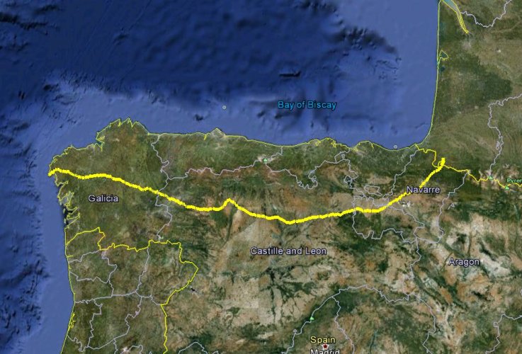
To see the Camino, you need to download a track. A track is a line on the image, and it can be downloaded from a file with a ,kml or ,kmz suffix. Download one of these files and put it where you can find it. From Google Earth, click file:eek:pen, and click on that file---whoosh, it will zoom to the track. Several tracks of different variations can be opened.


Once the track is open, you can turn on all sorts of layers, photos people have loaded, stores, hotels, restaurants, roads ,etc. You can tilt it to 3-d view.
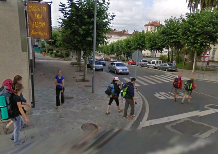
In the top right corner is the icon of a little man. Drag him onto the image, and “street view” roads become visible. Drag him to a place where the Camino crosses a road, and you’ll get a view from the street, often with pilgrims on the trail. This feature is great to see places you stayed, check out trail conditions for a bike, or just relive your trip. It is the most addictive time- waster you could ever dream of.

I’ll attach two files of different variations. They can be converted to .gpx files and loaded into a GPS with a site such as http://www.gpsvisualizer.com/convert_input
You can also draw the route you would like to take on Google Earth and save it, and load that into your GPS.
 

Attachments

  • 18.JPG
    18.JPG
    141.9 KB · Views: 9,650
  • Camino Frances Yellow.kmz
    258.3 KB · Views: 1,664
  • camino red line.kmz
    171 KB · Views: 779
Get a spanish phone number with Airalo. eSim, so no physical SIM card. Easy to use app to add more funds if needed.
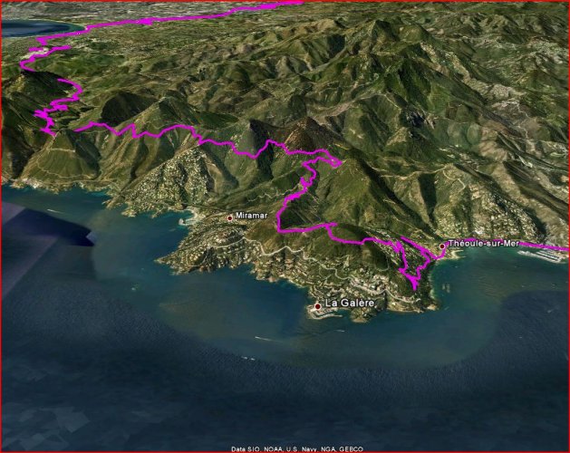
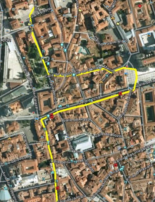
Here's some snips in various scales
 

Attachments

  • esterel.JPG
    esterel.JPG
    209.5 KB · Views: 9,482
  • 20.JPG
    20.JPG
    137.1 KB · Views: 9,466
  • 15.JPG
    15.JPG
    146.5 KB · Views: 9,446
Thanx newfydog for a really informative post, and for the files, really terrific!!

I had already been looking for camino route files on the web and have subsequently found that there are a number of them downloadable in various formats on WIKILOC, trails of the world.

http://en.wikiloc.com/wikiloc/home.do

Haven't seen this site referred to on the forum and it may be a useful resource.

Regards, John
 
Get a spanish phone number with Airalo. eSim, so no physical SIM card. Easy to use app to add more funds if needed.
Hello,
Thanks so much for this! Incredibly useful. Downloaded a couple files to google earth, but doesn't seem to function well offline. Any suggestions for best way to download for iPad? Know google just announced plans to allow offline access, but can't sort out and am starting camino del Norte in two weeks...
 
Google Earth only works online. It is far more useful sitting at a desk, wishing you were on the trail.

I frequently plan routes on google earth (you can download a track or click and trace one out). I then convert the .kmz file to .gpx, and load it into my gps, which works offline, all day, anywhere.
 
€2,-/day will present your project to thousands of visitors each day. All interested in the Camino de Santiago.
For routes, I have a gpx file for Portugese, il Primitivo and VDLP. I use them mainly to track myself as it is fun looking back in Google Earth or numerous other programs
 
newfy, hope it all goes well for you. You have made a really useful thread for people here- as much to dream with and reminisce with as anything!
Margaret
 
Ideal pocket guides for during & after your Camino. Each weighs only 1.4 oz (40g)!
Google Earth Animated Tour of the Camino Frances

As a user and fan of the program gmap-pedometer for planning my training hikes for my Camino later this year, I posted a question on the gmap-pedometer.com internal forum (and a similar question on this forum's Frequently Asked Questions board) asking if anyone had created gmap-pedometer routes for the Camino Frances. I received the following link in a response on the gmap-pedometer.com internal forum, which I thought I'd share here since it's mainly of interest to this particular Camino route. For those not familiar with Google Earth animated tours, it is a virtual flyover of a gps track that someone has saved and overlaid onto Google Earth satellite imagery -- in short, it's like flying along the entire length of the CF in a helicopter. Very interesting and most entertaining, but long -- it takes about 45 minutes on my reasonably fast computer.

http://www.gpsies.com/map.do?fileId=woj ... anguage=en

When you get to that web page -- which is a very good map in itself -- click on the link that says "Fly tour as Google Earth Animation" just beneath the map and next to the Google Earth icon to start the tour.

I wish I knew who created this so I could give him/her credit.

Jim
 
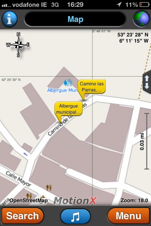
I find motion x to be the best app.
 
3rd Edition. More content, training & pack guides avoid common mistakes, bed bugs etc
The file Jim linked is a nice track. It has good detail, is in one segment, and goes to Finistierre. My Red Line in the original post is in a million pieces and dificult to put in a GPS. The Yellow and this gpsies file are easier.


I downloaded the track and will attach it here:


I converted it to a .gpx and sent it off to gpsimport@motionx.com
They return an email, which you open with your phone and download. It took 5 minutes, and now the entire Camino Frances is in my phone.

I tried to attach the .gpx file here but the .gpx file is larger and I get a message that.gpx file are not accepted(?!).

Anyway, if you go here,
http://www.gpsvisualizer.com/convert_input
you can make your own .gpx
 

Attachments

  • gpsies.kmz
    383.2 KB · Views: 104
Brilliant! It seems to import waypoints fine but not sure about tracks
 

Attachments

  • ImageUploadedByCamino de Santiago Forum1364830215.640564.jpg
    ImageUploadedByCamino de Santiago Forum1364830215.640564.jpg
    107 KB · Views: 4,376
clearskies said:
Brilliant! It seems to import waypoints fine but not sure about tracks

Tracks are emailed to them as a .gpx....see above post

They email it back. It is as fast as hooking up a gps to your computer.
 
The 9th edition the Lightfoot Guide will let you complete the journey your way.
Sorry, I'm inCaterbury, ready to head south on the Francigena, so I don't have my files. You need to google up a .kmz google earth file or .gpx GPS file of your route.
 
New Original Camino Gear Designed Especially with The Modern Peregrino In Mind!
newfydog said:
Sorry, I'm inCaterbury, ready to head south on the Francigena.
All the best! Bon courage, Bon Chemin for the start of it all!
Margaret
 
I have not been able to make any of these methods work.................:(
 
3rd Edition. More content, training & pack guides avoid common mistakes, bed bugs etc
Has anyone actually been able to get the Camino on your IPhone 4S using these sugesstions?
 
I have an iphone 5 and ipad and it goes on those no problem, as an offline map or online on google earth.


iphone frances.JPG iphone1.JPG iphone3.JPG
 
Thank you so much newfydog and Jim, very useful thread. Now i have the CF track on my iphone 4S, loaded on motionx. I will start my camino on sept 5th and the map will be with me all time, just in case.
 
New Original Camino Gear Designed Especially with The Modern Peregrino In Mind!
no, let us know what you find!
 
St James' Way - Self-guided 4-7 day Walking Packages, Reading to Southampton, 110 kms
Thanks for the info. I will bring my iphone and a nexus 7 so I'm interested in an android solution also. How can I have the .kmz file permanently saved on my tablet in order to get the track working offline?

Ricardo
 
Join our full-service guided tour of the Basque Country and let us pamper you!
I just downloaded Google earth onto my Android phone and the KMZ files from the link below work great, no need to convert them they just work.
http://www.elcaminosantiago.com/Camino-Santiago-Map-Google-Earth-Camino.htm

For google earth, you will need a cellular data signal. It eats data and battery pretty fast, so it is best used at home. You don't need cellular data for a GPS trace, so that is a good way to go on the trail.. MotionX will also let you go to satellite image mode if you want to see something out in the wilds and the signal is available.
 
For google earth, you will need a cellular data signal. It eats data and battery pretty fast, so it is best used at home. You don't need cellular data for a GPS trace, so that is a good way to go on the trail.. MotionX will also let you go to satellite image mode if you want to see something out in the wilds and the signal is available.

Good point. I forgot about data.
MotionX doesn't seem to be available for Android. I've just downloaded "Maps With Me Offline Map" from Google Play, it costs about 5 euro and it seems to do what's required. It isn't a satnav as such as it doesn't give directions, it just shows you where you are and will load KMZ files. There is a free version which I haven't tried, I think it does a similar job but it wont load a KMZ file?

Ricardo
You can connect your Nexus 7 by wire or WiFi to a computer and copy the file, or upload it to a service like dropbox. I think you would have to mark it as a favorite to make it available offline. Possibly easiest, email it to yourself as an attachment.
 
Ideal sleeping bag liner whether we want to add a thermal plus to our bag, or if we want to use it alone to sleep in shelters or hostels. Thanks to its mummy shape, it adapts perfectly to our body.

€46,-
Newfydog, then i won't be using google earth on the way, the iphone with motionx offline will be good enough.

Patgreen, thanks... I will use Dropbox to save the maps, i already have some files there. It works well for me because it's available for IOS and Android.

In the city, with wi-fi connection, the nexus 7 will be useful because i will be taking a lot of pictures and the larger LCD will be nice.

Ricardo
sorry about my english, i don't know if it's correct
 
.
It isn't a satnav as such as it doesn't give directions, it just shows you where you are and will load KMZ files. There is a free version which I haven't tried, I think it does a similar job but it wont load a KMZ file?


Yeah, you don't much need car type directions where there are no roads.

http://www.gpsvisualizer.com/convert_input will quickly convert a .kmz to a .gpx
 
St James' Way - Self-guided 4-7 day Walking Packages, Reading to Southampton, 110 kms
Has anyone actually been able to get the Camino on your IPhone 4S using these sugesstions?

Yes, I have.

Just putting together all information that newfydog and Jim have said:

1- Go here and download the kml version of the Camino Frances (just click the download button)

2- Go here and convert the kml file to a gpx file (mark the option GPX, select the kml file you have downloaded to your PC/Mac and click on convert button). The answer takes one minute or so)

3- Download the file converted to your PC/Mac (just click the download button)

4- Get the GPX file downloaded and e-mail it to gpsimport@motionx.com (they will respond in a few seconds)

5- install motionx gps (for iPhone) or motionx HD (for iPad), US$1,99

6- Open the e-mail received and click one of the two links (iPhone or iPad)

7- now the track is loaded into your iPhone/iPad and you're done (if I didn't have introduced any mistake :))

Buen Camino

Ricardo
 

Most read last week in this forum

Last year on my camino I was a bit annoyed when someone back home told me to enjoy my vacation. I bristled. Why did that word annoy me so much? I was on a pilgrimage! Anyway, I'm about to embark...
I'm looking for the best app to use whilst walking on the Camino. Usually I just rely on my Apple watch but I'm leaving that at home, so need an app use that I can pause at rest stops etc...
Everyone talks about the wonderful café con leche, but what if tea is more to your liking? Can you even get tea along the Camino (Frances)? I don’t drink coffee but my morning cup of tea is...
Hey all. I haven't been on the forum for quite sometime (years probably). I walked the Camino Frances in 2016 and to say it was life changing for me is an understatement. On day 3, at the café at...
I am just back from a few weeks on the Via the la Plata. Since 2015 I have been nearly every year in Spain walking caminoroutes I loved the café con leches. This year I did not like them as much...
When you stop at a bar for a beer, wine, coffee or bite to eat, and sit at a table, is it expected that you will return your dirty dishes up to the bar before you leave? I alway do, as it seems...

❓How to ask a question

How to post a new question on the Camino Forum.

Forum Rules

Forum Rules

Camino Updates on YouTube

Camino Conversations

Most downloaded Resources

This site is run by Ivar at

in Santiago de Compostela.
This site participates in the Amazon Affiliate program, designed to provide a means for Ivar to earn fees by linking to Amazon
Official Camino Passport (Credential) | 2024 Camino Guides
Back
Top