

Afri-Can
Not so new member
- Time of past OR future Camino
- Frances (2015)
Finisterre (2017)
Baztane (2019)
Norte (?)
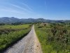
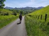
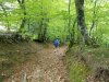
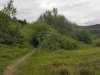
My family and I started the Camino Baztan in Bayonne on May 5 and ended 7 days later in Pamplona on May 11. This Camino proved to be a beautiful, beautiful route through the Pyrenees as reported on numerous websites and in this forum. The route, however, had a lot of surprises in store that we did not expect and did not plan for, and I will try to comment on our hike as best I can to help others that are considering walking this Camino.
First, some general comments and hints
And a little bit about our adventure
Our original plan was to stay over in Ustaritz, Urdax, Elizondo, Berroeta, Olague, Trinidad de Arre and end in Pamplona. However, we ended up staying over in Ustaritz, Urdax, Amaiur, Ziga, Lantz, Trinidad de Arre and ended in Pamplona.
This happened because we walked from Ustaritz to Urdax on a Monday, could not find anywhere to eat on Monday night or Tuesday morning, had to do the climb over the Pass of Otsondo on empty stomachs, ran out of steam and decided to stop in Amaiur after 10km instead of doing the 20km to Elizondo. We were really bushed and dehydrated when we got to Amaiur but fortunately we were able to have a really good lunch at the small bar there. Once the lady from the bar realized that we were pilgrims, she looked after us. She made us a really large dish of eggs, cheese, different hams, sausages and chips and also organized for us to stay in the casa rural right next door for €25 per person, breakfast included, for which we were very grateful since the albergue in Amaiur is still closed. This casa rural is not on any website or app.
We then decided to only do the 10km to Elizondo the next day instead of trying to catch up the “lost” 10km of the previous day. However, we arrived in Elizondo only to be told that the albergue only had 3 beds available and there were 4 of us. Also, the youth center just outside town would not take pilgrims. The bar lady was helpful enough to do the phoning and talking for us as my Spanish is very basic and not of phone conversation standard. We decided to buy food at the supermarket next door and walk on to Ziga where we found rooms at the Casa Rural Aldekoa. And what a beautiful and luxurious casa rural this restored old pig and cow shed turned out to be……at a price.
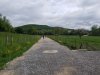
After Ziga, Lantz and Trinidad de Arre seemed logical layovers and all went according to plan for those 2 stages before we arrived in Pamplona. In Urdax there were 6 of us pilgrims in the monastery, but we 4 were the only pilgrims in the albergue in Lantz and the supper at the Posada in Lantz was excellent.
More on the two passes
Be aware, these 2 passes are not to be underestimated! I had my walking app going and the stats are below.
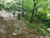
To get over the Pass of Otsondo we started in Urdax at around 9:15am and only got to the top of the pass (4.5km later) after 2 hours. Another 2 hours got us to Amaiur for 10km in 4 hours. We started at about 90m above MSL with the top of the pass at about 575m above MSL, which is roughly a 485m climb. However, with ups and downs it turned out to be a 583m climb.
To get over the Pass of Belate we started in Ziga at around 9:30am (the owner just shook his head when we explained that we were aiming for Lantz) and only got to the top of the pass (16km later) after 6 hours. Another hour got us to Lantz for 20km in 7 hours. We started at about 303m above MSL with the top of the pass at about 944m above MSL, which is roughly a 641m climb. However, with ups and downs it turned out to be an 1172m climb.
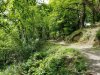
Beautiful, beautiful, beautiful but not an easy stroll.
And that’s it. Hope this is helpful to some.
First, some general comments and hints
- Getting from Madrid to Bayonne should have been a train ride to Irun and a bus ride to Bayonne according to Rome2Rio. However, it turned out to be 4 train rides to San Sebastian, Irun, Hendaya and Bayonne……apparently no buses.
- The pilgrim passports are still available inside the cathedral in Bayonne. I read somewhere that is wasn’t but we got ours there.
- This route is very quiet. The visitor book at the monastery in Urdax showed only 120 pilgrims from January 1st of this year. All Spanish pilgrims except for 5 (maybe I wasn't supposed to count but you have to fill in the register yourself). This in comparison to the French Way that apparently launches 500+ people per day. When we got to Trinidad de Arre, we found some very tired youngsters there that had to walk from Roncesvalles because they could not find beds in Zubiri or anywhere in between.
- All previous reports that I read, spoke of rain and mud…..we had very light sprinkles on two days and almost no mud to speak of. The weather was beautiful and warm during our walk.
- English is rarely spoken or understood on this route, so basic Spanish goes a long way.
- The route is much tougher than we expected. I can’t remember the walk to Roncesvalles, La Faba or O’Cebreiro being as difficult as the two climbs on this trip. My wife disagrees. Maybe I'm just weak. Beautiful, beautiful, beautiful but strenuous. If you have walking sticks, take them.
- Everything is closed on Mondays……seriously. And sometimes Tuesdays as well. Even restaurants and bars that advertise as being open might be closed so don’t bank on anything. Make sure you have something to eat and drink with you at all times.
- Everything is closed from around 2:00pm to 5:00pm..….siesta, I guess.
- You don’t find the standard pilgrim menu on this route. You eat what they have on their menu or what they want to prepare for you and you pay normal rates.
- There are a lot more places to stay (casa rurals and hotels) than shown on the Buen Camino app, the Kelly guide or on Google Maps and you pay normal rates.
- The albergue in Elizondo doesn’t really seem to be an albergue. It seems to be a hybrid that also acts as an albergue, so they might be full although you may be the only pilgrim around. They do have good food though and there is a good supermarket next door. In addition, the youth facility in Elizondo would not take pilgrims.
And a little bit about our adventure
Our original plan was to stay over in Ustaritz, Urdax, Elizondo, Berroeta, Olague, Trinidad de Arre and end in Pamplona. However, we ended up staying over in Ustaritz, Urdax, Amaiur, Ziga, Lantz, Trinidad de Arre and ended in Pamplona.
This happened because we walked from Ustaritz to Urdax on a Monday, could not find anywhere to eat on Monday night or Tuesday morning, had to do the climb over the Pass of Otsondo on empty stomachs, ran out of steam and decided to stop in Amaiur after 10km instead of doing the 20km to Elizondo. We were really bushed and dehydrated when we got to Amaiur but fortunately we were able to have a really good lunch at the small bar there. Once the lady from the bar realized that we were pilgrims, she looked after us. She made us a really large dish of eggs, cheese, different hams, sausages and chips and also organized for us to stay in the casa rural right next door for €25 per person, breakfast included, for which we were very grateful since the albergue in Amaiur is still closed. This casa rural is not on any website or app.
We then decided to only do the 10km to Elizondo the next day instead of trying to catch up the “lost” 10km of the previous day. However, we arrived in Elizondo only to be told that the albergue only had 3 beds available and there were 4 of us. Also, the youth center just outside town would not take pilgrims. The bar lady was helpful enough to do the phoning and talking for us as my Spanish is very basic and not of phone conversation standard. We decided to buy food at the supermarket next door and walk on to Ziga where we found rooms at the Casa Rural Aldekoa. And what a beautiful and luxurious casa rural this restored old pig and cow shed turned out to be……at a price.
After Ziga, Lantz and Trinidad de Arre seemed logical layovers and all went according to plan for those 2 stages before we arrived in Pamplona. In Urdax there were 6 of us pilgrims in the monastery, but we 4 were the only pilgrims in the albergue in Lantz and the supper at the Posada in Lantz was excellent.
More on the two passes
Be aware, these 2 passes are not to be underestimated! I had my walking app going and the stats are below.
To get over the Pass of Otsondo we started in Urdax at around 9:15am and only got to the top of the pass (4.5km later) after 2 hours. Another 2 hours got us to Amaiur for 10km in 4 hours. We started at about 90m above MSL with the top of the pass at about 575m above MSL, which is roughly a 485m climb. However, with ups and downs it turned out to be a 583m climb.
To get over the Pass of Belate we started in Ziga at around 9:30am (the owner just shook his head when we explained that we were aiming for Lantz) and only got to the top of the pass (16km later) after 6 hours. Another hour got us to Lantz for 20km in 7 hours. We started at about 303m above MSL with the top of the pass at about 944m above MSL, which is roughly a 641m climb. However, with ups and downs it turned out to be an 1172m climb.
Beautiful, beautiful, beautiful but not an easy stroll.
And that’s it. Hope this is helpful to some.


")


 atop the fountain in Hornillos. I must have taken twenty photos of him over the years.


