Search 69,459 Camino Questions

Planning a trek

Kenknight

New Member
Time of past OR future Camino
Considering the Primitivio (2016)
Like many i am considering a trek of the Primitivio this spring. But I suspect I am a bit unusual. I am an experienced backpacker and have covered large parts of trails like the Appalachian Trail and North Country Trail. I've backpacked across the Scottish highlands. This is not uncommon. However, I am legally blind. I have very low vision. In some ways the hardest part of a hike on a marked trail for me is following the markets. I am more likely than not to not see a way marker. I am a competent map reader but hiking marker to market is actually tough. Following a trail is not an issue though I do care more about footing than most. In some ways I suspect finding my way on the Primitivio especially in towns could be a challenge. How often are you confronted with confusing road choices?

I'd be happy to do the journey with a partner. I'm not planning to hurry. The route Liz proposes in her excellent guide would be fine by me though I could go faster. I'd like to start mid- to late April and I'd go all the way to the coast at Muxia. Also, if it matters I am coming from the States: Michigan to be precise.
 
New Original Camino Gear Designed Especially with The Modern Peregrino In Mind!
Welcome @Kenknight,

As I was reading your post I kept thinking a walking companion would be the best option. And it turns out it is what you are hoping for. And you are correct, visual awareness of markers is key to the Camino.

In some cemetaries tombstones know have technology embeded in them that talk about the dead. Wouldn't it be great to have that technology embedded in the markers?

To this day I have only seen 1-3 km of Camino built with the visually impaired in mind. Somewhere between Burgos and ... Leon?

I don't think this forum has a section for people looking for walking partners, but if I was walking the Primitivo this spring I would be more than happy to enjoy your company. May you find people walking this route when you are planning to and may you enjoy each other's company and learn from each other.
 
Hi there, kenknight. It might be difficult starting the hike the same dates, and it might be even more difficult to tell before the start of the camino, if we'll get along well together, but I sure would be happy to give it a try, if we could meet along the way. I plan to continue from Oviedo May 9th, but I really can't tell the exact date for sure as I start in Hondarribia and will be in the Picos as well. If interested, write me.
 
The 2024 Camino guides will be coming out little by little. Here is a collection of the ones that are out so far.
Hi there, kenknight. It might be difficult starting the hike the same dates, and it might be even more difficult to tell before the start of the camino, if we'll get along well together, but I sure would be happy to give it a try, if we could meet along the way. I plan to continue from Oviedo May 9th, but I really can't tell the exact date for sure as I start in Hondarribia and will be in the Picos as well. If interested, write me.
Niels, well the timing likely would not work but thanks for replying. Starting Ma 9 is probably a good week or so later than I'd like. I'm trying to ensure I'm back on n the States for an annual backpacking trip over the Memorial Day weekend which means been big back by the 24th.
 
For me the question of navigation revolves around the type of paths, trails, roads you follow. Is it more akin the something like The West Highland Way in Scotland or are the paths more a blazed hiking mountain trail in the States (my experiences of hiking in Europe suggest this is rather unlikely but I'm tossing it out as a point of context) . It's at intersections that I'd have to watch carefully. Ironically, in places where I'd have to go strictly by map it could be easier (I know that's not how the Caminos are).

Can you follow a Camino path successfully if you miss seeing more markers than not but have maps (not that the maps I've seen are that good but I bet I just haven't found the right ones)? How big and contrasty are the markers?
 
Niels, well the timing likely would not work but thanks for replying. Starting Ma 9 is probably a good week or so later than I'd like. I'm trying to ensure I'm back on n the States for an annual backpacking trip over the Memorial Day weekend which means been big back by the 24th.

That's o.k. Hope you'll get along well. Buen Camino.
 
The one from Galicia (the round) and the one from Castilla & Leon. Individually numbered and made by the same people that make the ones you see on your walk.
@Kenknight I am considering the Primitivo and would walk with you but I won't get there til much later in the year - and I'm a very slow walker so that would drive you nuts. @peregrina2000 has walked this route a few times so she can answer your questions. Even if you have nothing arranged before I suspect you will meet plenty of pilgrims on the route who will be willing to lend a hand.
 
For me the question of navigation revolves around the type of paths, trails, roads you follow. Is it more akin the something like The West Highland Way in Scotland or are the paths more a blazed hiking mountain trail in the States (my experiences of hiking in Europe suggest this is rather unlikely but I'm tossing it out as a point of context) . It's at intersections that I'd have to watch carefully. Ironically, in places where I'd have to go strictly by map it could be easier (I know that's not how the Caminos are).

Can you follow a Camino path successfully if you miss seeing more markers than not but have maps (not that the maps I've seen are that good but I bet I just haven't found the right ones)? How big and contrasty are the markers?

Hi, Kenknight,
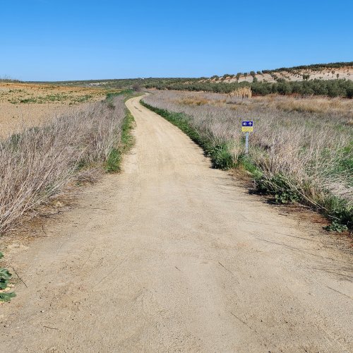
Welcome to the forum. The Primitivo is not a rugged mountain trail, but it is well marked. There are official granite bollards (called mojones in Spanish) with yellow arrows or shells pointing the way, and there are also many places where yellow arrows are painted on walls, on trees, on all sorts of permanent physical structures. Sometimes the arrows are small and don't jump out at you, but they tend to be there when you need them so you would find them if you look for them. Though the Primitivo has a lot of off-road sections, it just takes you through the towns and villages on pavement and then out to a junction with the off-road trail again.

My own favorite way to see a map of a Camino is to zoom in on gps tracks, because the maps show a lot of detail and real pictures of what's actually there on the ground. Look at wikiloc.com there are tons of Camino Primitivo tracks there. Here is one GPS track of the entire Primitivo: http://www.wikiloc.com/wikiloc/view.do?id=10678727

You could also get a GPS with a beeping function to warn you when you miss a turn, but that might drive you crazy, as well as eat up the batteries very quickly.

I think you will find others walking at the time you plan to go. I would start in the Oviedo albergue, because everyone in there on the night you arrive will be starting out on the Primitivo the next day. Buen camino, Laurie
 
@peregrina2000 as the OP is legally blind, with very low vision, do you think finding the arrows and markers will be a problem? I guess I am asking how much of the trail is on a well formed track.
 
A guide to speaking Spanish on the Camino - enrich your pilgrim experience.
@peregrina2000 as the OP is legally blind, with very low vision, do you think finding the arrows and markers will be a problem? I guess I am asking how much of the trail is on a well formed track.

Hi, Kanga, That's hard for me to assess since I haven't paid attention to that feature of the marking while walking. But (and others should jump in here if they disagree), I think the path is all on well formed tracks, no wilderness bushwhacking or devious little turns that are hidden from view. I've walked this route twice, never with a guidebook, but of course I have full vision. I got waylaid off the trail for a while outside Cornellana near some train construction, but found myself on a pretty little road that went right into town. I would say that's the normal consequence of losing your way, you will find yourself on a country road and have to be pointed towards the next town where you will find the camino again.

The one place where you are removed and in a more remote hilly area is on the Hospitales route from Borres to Puerto de Palo, but that is extremely well marked. Visibility can be a problem with fog, and I wouldn't go up there with snow, but for everyone, regardless of your vision, the best advice on the Hospitales route is to go with someone.

My gut tells me, though, if Kenknight has walked parts of the AT, the Primitivo will not present a challenge in terms of following the marking with limited vision. What do the other Primitivo veterans say?
Buen camino, Laurie
 
A typical blaze on the Appalachian Trail, really any blazed trail that uses this style of blaze, is a rectangle approximately 2 inches wide by 6 inches tall (5x15cm). On the Appalachian Trail the blazes are white and side trails are blue. Other trails that use rectangular blazes use different color schemes. Most people will be able to see the next blaze from the blaze they are standing by on a highly marked trail. In my case I see the blaze as I am passing by or if I take out my monocular and look specifically for the blaze. The size of the blaze is important but the contrast of the blaze against what is painted on is also key. Yellow blazes like those arrows on the Camino should be fairly easy to spot however my guess is scallop shells could be tougher if they really are just shells.
 
A typical blaze on the Appalachian Trail, really any blazed trail that uses this style of blaze, is a rectangle approximately 2 inches wide by 6 inches tall (5x15cm). On the Appalachian Trail the blazes are white and side trails are blue. Other trails that use rectangular blazes use different color schemes. Most people will be able to see the next blaze from the blaze they are standing by on a highly marked trail. In my case I see the blaze as I am passing by or if I take out my monocular and look specifically for the blaze. The size of the blaze is important but the contrast of the blaze against what is painted on is also key. Yellow blazes like those arrows on the Camino should be fairly easy to spot however my guess is scallop shells could be tougher if they really are just shells.

Hi, Ken,
Scallop shells are rarely used as way markings. In most cases they are used as decorations and sometimes pointers on big granite bollards. (The only place I know of where a yellow scallop shell freestanding on a pole is used as a marking is on the Camino del Salvador). It is not always the case (in fact I would say it is infrequently the case) that you can see the next arrow while standing at an arrow. Yellow arrows on trees make a pretty good contrast. The granite bollards, called mojones in Spanish, are pretty blah in terms of color, but I wonder if their large size would make up for that. They tend to be about three feet tall and with at least a square foot or two at the base.
 
Last edited:
Join our full-service guided tour and let us convert you into a Pampered Pilgrim!
I hope this is helpful @Kenknight - keep us informed. Great info Laurie. Of course, Ken, if you have problems you could always switch to the Camino Frances - there would be plenty of fellow pilgrims on that path to keep you on the straight and narrow!
 
While the Camino Frances is an option one appeal of the Primitive is that it will likely be less busy and seems like it has a nicer mix of passing through towns, villages, and more remote places. I'm looking at things and we will see what develops. My gut feeling now is the toughest bits will be those times entering/leaving towns and finding necessary things (e.g., groceries) while in town. I've no doubt I can do these things but errands always take me longer than they do other people. One way or another I think I'll know if this is a go within a couple of weeks. If it does come together I will write about the whole trip from getting ready to the return home at the end.
 
Sheesh, I hate to say this, but I would be cautious. And frankly this could be a project for the associations and towns as they invest in the Camino: make the markers bright and clear.

When walking the Primitivo, in pants, I kept thinking of Macabi skirt wearers and being so glad I was not in a skirt. Quite enough prikly plants to walk through.

And let's not forget some areas where one has to hug boulders while facing on coming trafic, such as when arriving in Esclampero.

Or walking from the Grandas hotel up the hill...

I really would love to be able to help you walk that trail @Kenknight , as it is calling me back and would enjoy sharing it with someone else.
 
Get a spanish phone number with Airalo. eSim, so no physical SIM card. Easy to use app to add more funds if needed.
Sheesh, I hate to say this, but I would be cautious. And frankly this could be a project for the associations and towns as they invest in the Camino: make the markers bright and clear.

When walking the Primitivo, in pants, I kept thinking of Macabi skirt wearers and being so glad I was not in a skirt. Quite enough prikly plants to walk through.

And let's not forget some areas where one has to hug boulders while facing on coming trafic, such as when arriving in Esclampero.

Or walking from the Grandas hotel up the hill...

I really would love to be able to help you walk that trail @Kenknight , as it is calling me back and would enjoy sharing it with someone else.
Road walking doesn't worry me. Not as far as worrying about traffic is concerned. I don't like it but it wouldn't be a first time. Nor do I worry about prickly plants. I've done my share of backpacking and hiking in the desert southwest. On a road walk I'd worry about missing a turn because I didn't see a market across the road from where I am.
 
Some of the marking is not very clear. Thinking of Puerto de Palo and also over Buspol down to the dam before Grandas. The alternative would be to walk the road as suggested for bad weather. On the downhill stretch after Buspol the marking posts give a route out to the road for cyclists. The walkers' track is very narrow and steep with an almost vertical drop to the left. That is one section where you probably would need to take the alternative route unless you have company.
 
Some of the marking is not very clear. Thinking of Puerto de Palo and also over Buspol down to the dam before Grandas. The alternative would be to walk the road as suggested for bad weather. On the downhill stretch after Buspol the marking posts give a route out to the road for cyclists. The walkers' track is very narrow and steep with an almost vertical drop to the left. That is one section where you probably would need to take the alternative route unless you have company.
Thanks. I'll point out, realizing you couldn't know, that steep slopes with drop offs aren't an issue. They be slow going but I'd not worry about them just because they're tougher hiking.
 
Technical backpack for day trips with backpack cover and internal compartment for the hydration bladder. Ideal daypack for excursions where we need a medium capacity backpack. The back with Air Flow System creates large air channels that will keep our back as cool as possible.

€83,-

Most read last week in this forum

Hi all! Started today from Oviedo to Escamplero. Now I know, why so many people say it's a bit of a challenge to come out of Oviedo. I got lost just once, but was rescued by a very friendly guy. A...

❓How to ask a question

How to post a new question on the Camino Forum.

Forum Rules

Forum Rules

Camino Updates on YouTube

Camino Conversations

Most downloaded Resources

This site is run by Ivar at

in Santiago de Compostela.
This site participates in the Amazon Affiliate program, designed to provide a means for Ivar to earn fees by linking to Amazon
Official Camino Passport (Credential) | 2024 Camino Guides
Back
Top