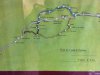
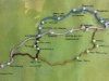
The Red one is the Pola de Allande route used nowadays.
The White (or grey) one is the Hospitales route although the Hospitales route just passes through the Northern most edge of La Mortera.
The Blue one is an (AFAIK) unused ancient detour/variant taken by pilgrims that visited the Monastery of S. Miguel (St. Michael) in Bárcena del Monasterio.
The Yellow one, I'm not sure about it. There was a
direct route from Tineo to Pola that didn't go through Obena. It seems to me that the route showed on the map is a liaison from Obena (let's recall King Alfonso IX
forced pilgrims to go through Obena) to a close to Obena point of the
direct route (either Gera itself or somewhere before Gera) continuing from that point onwards on the
direct route. Maybe, once pilgrims were forced to go through Obena, some of them looked for the way to link Obena with a close point to Obena in the former route so they could return to
known territory as soon as possible being that the route showed on the map but that's just a guess.
If you read Spanish, take a look at
Nuestras raíces patrimonio histórico written by Manuel (Fernández) de la Cera and available at his web:
http://manueldelacera.com/articulos/libros.html for detailed info about camino routes and history in the area of Tineo.