• For 2024 Pilgrims: €50,- donation = 1 year with no ads on the forum + 90% off any 2024 Guide. More here.
    (Discount code sent to you by Private Message after your donation)
  • ⚠️ Emergency contact in Spain - Dial 112 and AlertCops app. More on this here.

Search 69,459 Camino Questions

Access issues on mountain alternatives near Segura & before Zegama

WestKirsty

Active Member
Time of past OR future Camino
Next up: Viejo/Olvidado
Greetings,
I am planning to walk the Vasco this Easter break and have been trying to find ways to walk the mountain alternative. A friend was over yesterday and she walked 3 stages on that route a few weekends ago ((1) Lasarte-Oria to Bidegoian (2) Bidegoian to Zegama (3) Zegama to Salvatierra) and wanted to share information about the route.

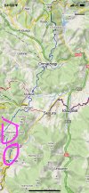
Unfortunately, there were 2 points on the trail where fences have been put up with Private Property signs. The first was along the trail near where the alternative reconnects with the main route (between Zerain and Segura). There is a property there that the trail went through but apparently is now fenced off. My friend went through anyway (apologizing out loud) as there wasn't a clear alterative at that point lest she walk back up the mountain. No one was around so there were no issues.

The second was closer to Zegama where the mountain alternative approaches the highway. This time the route was blocked by a fence and there was a dog on the other side. She backtracked a bit and then walked the final few Km to Zegama on the side of the main road.

If others are planning to walk these alternatives, better to know in advance! She was gutted by the first block as it had already been a 30+km day in the mountains.


We were examining wikilocs and maps yesterday and think we've found some alternatives:

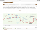
There is a trail that connects the mountain alternative to Tolosa (so the route would be Hernani via the mountains until Iturrioz where you can take the GR 285 to Tolosa and stay there (https://www.wikiloc.com/hiking-trai...eltz-herniozabal-munoaundieta-tolosa-41557854) It would probably be about 35km so a full day but if the weather is decent in April I might try this out!

My friend also mentioned that there was a connecting route from the mountain alternative to the main route between Salbatore and Beasin.

So if these fences are indeed an issue, there might still be options to do the mountain alternative and reconnect with the main trail before Zegama.

Happy walking!
 
Down bag (90/10 duvet) of 700 fills with 180 g (6.34 ounces) of filling. Mummy-shaped structure, ideal when you are looking for lightness with great heating performance.

€149,-
It sounds like you have totally scoped this out, so I assume you have looked at the brochures on the Saiatz alternative posted by Peregrina2000? If not they are pinned to the top of this forum. Will you post live while walking? I am dying to know how it goes as we will be about three weeks behind you (starting in Irun on 14 May). Buen Camino!
 
It sounds like you have totally scoped this out, so I assume you have looked at the brochures on the Saiatz alternative posted by Peregrina2000? If not they are pinned to the top of this forum. Will you post live while walking? I am dying to know how it goes as we will be about three weeks behind you (starting in Irun on 14 May). Buen Camino!

Yes, I'd be happy to post live updates! It's getting closer and I'm quite excited! :)

And yes, the mountain route I'm referring to here with access issues is the alternative proposed by Peregrina2000 (2B and 3B in those brochures). They seem to be quite prominent on the maps so I was shocked when she told me her issues on the trail!

I actually live in Bilbao in the Basque country so this route is quite close to home for me. So I have the updated maps from the tourist office with that alternative and maybe I can find someone in the Camino Association here to ask about it. My friend who did the walking and I might also go back some weekends for day hikes as she said the area is beautiful and worth exploring.

I was on the Gronze website the other day and noticed a few Albergues (Andoain and Beasain) are planning to open again April 1st so we might be in luck accommodation wise! That's a great source of information on accommodation options, if you haven't seen it already.

As I haven't walked the trail yet, I'm no expert, but happy to share any information I come across in the planning and if you have questions about the Basque country :)
 
3rd Edition. More content, training & pack guides avoid common mistakes, bed bugs etc
Like you, I’m surprised to see this news, because these are routes that are walked by a lot of day hikers. When I went from Orio to Errezil, for instance, we didn’t see any other pilgrims, but we saw LOTS of day hikers.

I am not totally clear on where these fences are, but you may get help and advice from the association —


They have an email address, caminosnorte@caminosnorte.org

Their website only lists the “traditional” Vasco route, but I bet they will have some information or suggestions.

Keep us posted. This was probably the hardest three day walk I have ever done (at least at the beginning), from Irún to Zegama, but also probably the most beautiful.

Thanks very much for the email! I have sent them a message to see if they can provide any information/clarification.

I asked my friend for more detail on location and I've attached a pic of the map here. The areas where she had problems are circled (more or less). She had no issues on the first day out of Oria and, like you, saw lots of day hikers.

The problems came towards the end of her second day as she got close to Zegama. On the picture, you can see the mountain variant down the middle whereas the traditional route comes in from the right and is paired with a red GR route (though Idiazabel). The blue line disappears a bit as the trail is along the road (yellow line).

She is suggesting that if someone is on the mountain route, take the GR route between Zerain and Segura (red on the map) and then follow the rode to Zegama.

I'll pass on any information I get from the association and my own travels next month.
 

Attachments

  • WhatsApp Image 2022-03-11 at 3.32.46 PM.jpeg
    WhatsApp Image 2022-03-11 at 3.32.46 PM.jpeg
    302.7 KB · Views: 10
Thanks for the specific info. We slept in a kind of weird place in Ormaiztegui, and then had a very short, very unremarkable, and very pleasant day into Zegama. I am sure we had no problems with access. I’ve gone back over my pictures and don’t see any fences, just beautiful views and greenery!

Looking at gronze’s map (they do not show the Saiatz alternative), they do show an alternative to Zeraín and then on to Zegama. I believe that the Zeraín to Zegama alternative they show is actually the Saiatz alternative! So going from Zeraín over to Segura seems to put you back on the “official” Vasco and you enter Zegama that way. I hope that makes sense.

Anyway, I think the workaround is not a terrible choice, especially if you know about it ahead of time and just head over to Segura when you reach Zeraín.

But I would love to hear about why the property owners are so bothered to put up fences. Surely this is not a part of Spain where hoards of unruly trash-throwing walkers are blaring music and disturbing the peace! Unfortunately, it may not have enough of an on-the-ground community that wants to push the envelope and get some clarity. Because the behavior is very possibly illegal. Ender on the Salvador fought several battles with landowners who repeatedly and illegally tried to block people, but if there’s no one to fight it, they get away with it!

Good luck, and please do keep us posted.
 

Attachments

  • 9A7E1485-6DC3-409E-B150-3415BA8E9D31.png
    9A7E1485-6DC3-409E-B150-3415BA8E9D31.png
    970.1 KB · Views: 6
Technical backpack for day trips with backpack cover and internal compartment for the hydration bladder. Ideal daypack for excursions where we need a medium capacity backpack. The back with Air Flow System creates large air channels that will keep our back as cool as possible.

€83,-
I've heard back from the association and pasted the response below. It seems as though the association focuses on the original, main route, which is the one most pilgrims use. He mentions the new path along the side of the road specifically for walkers and cyclists on the approach to Zegama as being the suggested route.

Apparently he also had similar access issues when the arrows were placed several years ago and will re-arrow the alternate path this summer in light of the problems pilgrims may face if they are on the alterative path these days.

The original response is here as there are no doubt many on this forum with much better Spanish than I have and can correct me if I've misrepresented anything!


La verdad el camino de Saiatz como lo denomina el Gobierno Vasco es muy poco transitado por peregrinos y, acaso nuestra Asociación lo tiene un poco abandonado, no obstante, cuando bajas hacia Zegama, acaso te resulta mejor retroceder un poco hacia la carretera, ya que el Ayuntamiento de Zegama, paralelo a la carretera ha instalado un bidegorri o camino especial para bicis y peatones.

Yo particularmente me ocupo de remarcar las flechas amarillas y la última vez lo hice hace varios años y efectivamente tuve el problema que me comentas, pero ahora con el bidegorri, ha mejorado mucho el acceso a Zegama sin peligro de los coches,

A la vista de tus comentarios, este verano remarcaré nuevamente el camino, saludos,
 
THANKS!!! My rough translation.

In truth, the Saiatz alternative (which is the name given to the route by the Basque Government), is very untraveled. Our Association has abandoned it a bit, but nevertheless when you descend towards Zegama, it’s probably better to go to the road. The municipal government of Zegama has installed a bike/walking path (bidegorri is a good Basque word to learn).

I am in charge of repainting the yellow arrows and the last time I walked it, a few years ago, I had the problem that you describe. But now with the bidegorri, access to Zegama is much improved without any danger from cars.

In light of your comments, this summer I will repaint the arrows. Regards.


So it seems like this has been an issue for a while. Strange that when we walked in 2019 there was absolutely nothing blocking our way.

But anyway, it does sound like your workaround is the way to go, and will not detract from the beauty of this Saiatz alternative.

Looking forward to a first hand update, buen camino! Laurie
 
Hello again! I wrote the original post in March after hearing from a friend who opted to walk the mountain alternatives of the Vasco over a long weekend. I've now had the chance to explore the area she had trouble with and can provide a little more context/info for those heading out on the Vasco.

The section where someone might run into problems is not actually the Saiatz Alternative route as promoted by the Associations/tourism in the area. If you look here at the alternative maps, the Saiatz route reaches Zerain and then heads towards Segura where it rejoins the main route. Following this trail doesn't lead you into Segura, you need to cross a bridge and head up into the town if you want to see it. It is a marked trail, with yellow arrows. I've attached a screenshot of Mapy.cz, which I often use on walks. The section from Zerain to Segura isn't marked as a Camino on this app/map (the red line), but it is clearly meant to be an official trail.

Zegama to Segura_Comments.jpg

My friend had issues going from Zerain to Zegama - the route shown on Gronze and talked about in this thread a few years ago.

When I left Zerain I didn't see any yellow arrows marking this trail but I could follow the blue line on Mapy.cz (blue line in the picture). Reading through the forum, others do mention that you reach private property. There are fences and signs and I suppose it just depends on your comfort level of going through them. I didn't, when I was in the area, but walked back to Segura and then also tried the route in the other direction to see what the parts closer to Zegama were like - I had time :)

Near the private property my map directed me to an off-road path but this was impassable (overgrown and a wire/cable fence blocking the way). However, here you can just walk on the road and get into Zegama easy enough. CAUTION: lots of forestry in this section. When I went by, a man was above me on the ridge in the process of chopping down a tree. He saw me (I made sure of that!) and put the chainsaw down.

One other issue - if you take this road down into the valley, there is a yellow arrow pointing right before you cross the creek and get to the main road. This path is definitely blocked - leads right into someone's yard, which is fenced off all the way to the creek. But you are close to Zegama here anyway, just cross the creek on the road bridge and head straight for the main route/road into Zegama.

Zerain to Zegama_Comments.jpg

I hope this helps! I would suggest that if you're coming down off the Saiatz Alternative, just keep following the arrows towards Segura and use the main route into Zegama.

For those wanting to get off of the pavement and into the hills between Zerain and Zegama, just be aware that you'll need to walk through private property and an active forestry area.

The local/regional governments spent a lot of time and money on the bidegorri (cycle/walking path) between Segura and Zegama and in speaking with the Asociación de Amigos de los Caminos de Santiago en Guipúzcoa there doesn't seem to by any desire to make the section referred to here an official variant. They stated it was useful when the main route was on the shoulder of the busy road, but now it is no longer necessary.

Just let me know if there are any questions or clarifications needed :)
 
Join our full-service guided tour of the Basque Country and let us pamper you!

❓How to ask a question

How to post a new question on the Camino Forum.

Forum Rules

Forum Rules

Camino Updates on YouTube

Camino Conversations

Most downloaded Resources

This site is run by Ivar at

in Santiago de Compostela.
This site participates in the Amazon Affiliate program, designed to provide a means for Ivar to earn fees by linking to Amazon
Official Camino Passport (Credential) | 2024 Camino Guides
Back
Top