haven't yet walked this route yet but I am planning to the next time I am there. speaking of, if going in reverse, would the waymarking be just as good?
this is the english text from the site mikevasey posted, the woods look especially beautiful:
The Way of St James has existed for over a thousand years. It was one of the most important Christian pilgrimages during medieval times. It has undergone lot of changes over the years . Some very interesting routes have disapeared, some others have fallen out of use and some of them, which are still in good use, are not very well known amongst the pilgrims, as the most guide books do not mention them.
As you can imagine these little routes are much more interesting for those pilgrims who are looking for a more genuine experience .
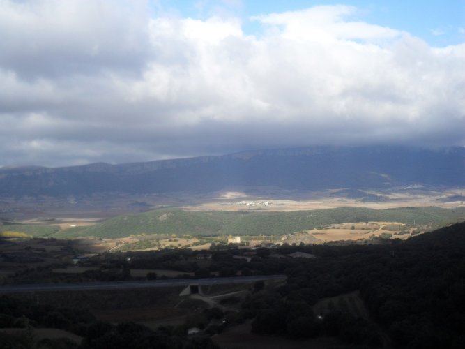
The route I am offering you is one of them. It is just a little one. It is only about three or four kilometres long. It goes from Villatuerta to Luquin (before arriving at Estella). It was very popular before the foundation of Estella, about 1000 years ago. It starts near the Zaraputz plain and finishes in Luquin. It goes around Mount Montejurra and offers you fantastic views, intense smells (variable in every season) and a nice walk among holm oaks, oaks and pine trees.
Long time ignored, after the Ega river flooded and destroyed the bridge wich allowed the access to this route, it has now been restored by a private initiative, since a new bridge has been built very near the old one.
Originally It goes from Villatuerta to Luquin .You can also follow it from the new route in the”Monasterio de Irache”. If you are heading towards Los Arcos at about 300 metres there is a crossroads where you can take this beautiful path along where you can take in fantastic panoramic views of, Loquiz, Urbasa , Monjardin and San Donato mountains on one side and , Cantabria, Yoar and San Lorenzo mountains on the other.
and this is my description that I did after googlemaps (mostly, the second part was a problem due to all the paths towards Luquin and I used
brierley here), because
john brierley's just didn't seem detailed enough. although if the route is so excellently waymarked as everyone says, it may not be needed. Please note that this is made after googlemaps and may NOT correspond with the waymarks. It gives you a general direction, though. Distances mostly after
Brierley.
VILLATUERTA (F, wc, 423m) From albergue continue on the main route along Calle Rúa Nueva to igl. de Asuncion (F) and plaza after it.
Alternative along an older medieval route directly to monasterio de Irache and further to Los Arcos: Before Estella was founded in 1090, the pilgrims travelled directly to monasterio de Irache (8km) via Noveleta and Zaraputz and this route continued to be used later on as well. It can be extended via Luquín to link directly with Los Arcos (20km in all). It is marked as part of GR 65.
A blue board on a casa here has a small yellow arrow with Zaraputz written on it. Turn L along Calle Iglesia, cross a street at the end and continue on a path then a track past an industrial complex (R), veer L under NA132 where it joins the motorway and reach a gravel road that to the R leads to the first houses of
1.7km NOVELETA.
Continue on this gravel road L, go under the motorway, turn R, make a L bend, turn R across río Ega and turn R on a path along the river. The path soon veers L away from the river for a steep climb to the ruins of a
3km 15C hospital de peregrinos (founded by monks from s Juan de la Peña and in 1090 mentioned as in camino de Sancto Iacobo) in Zaraputz (R, 440m), then it parallels a road (L). It crosses a tarmac road, turns L and crosses NA122 via a pedestrian bridge.
Ascend to a gravel road on a ridge (515m; views of Estella), turn R on it as it curves around a valley and ascends to the start of a tarmac road at cementerio (R). Turn L here to a path that curves along a scrubland with a lonely tree (L) and 100m after the tree, as it bends R, turn L into the scrubland. 10m later turn R to a well-trodden path that ends on a gravel/tarmac road. Go R for 100m and turn L to another well-trodden path (after the second small tree(?)) that descends through oak forest to an intersection before the
3.7km motorway.
Here you can pass under the motorway then go straight to join the main 0.4km Camino Francés; monasterio de Irache (F) is further 800m to the L. Albergue in Ayegui is 1.2km past Irache, and albergues in Estella are 2.7km that way.
If you want to continue directly to Los Arcos, turn L before the motorway up through an oak woodland that eventually gives way to extensive lavender fields, skirting the lower slopes of the mystical mountain of Montejurra (1045m). Descend to a wooden bridge across a
3km dry stream and shortly after gradual climbing uphill through mountain oak the path emerges out of the woods to reveal the wonderful views of the conical peak of Mojardín to the N. You reach the high point (720m, views) and then gently descend to
3.7km LUQUÍN (F, s Martín (carved portico)). Below is URBIOLA where the knights of St. John maintained a medieval hospital de peregrinos.
Wind you way down through the village to NA6340, turn L then veer R to Calle Carrera which becomes a dirt road above N111. In a fork veer R, cross N111 then go under the motorway and the
3.7km main route below a small pine grove.
whichever route you will take, I am sure you can't be disappointed.