Search 69,459 Camino Questions

Alternative from Borrenes to As Médulas— 2019 guide

peregrina2000

Moderator
Staff member
A few months back, @amancio suggested an alternative from Borrenes up to As Médulas. Here is what I propose for the guide. Any comments from those who have done it or questions from those who find what I’ve written to be confusing?

PROPOSED TEXT
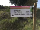
Alternative route from Borrenes to As Médulas. This off-road route takes you straight to the iconic Orellán lookout (Mirador de Orellán), the spot of the best views of As Médulas. You will also pass the galleries (open for visits), the ancient tunnels that pushed the water through at increasing speeds so it would blow up the hills and disgorge the gold. From there you can either go down to the village of As Médulas, or bypass the village entirely by carrying on to Puente Domingo Flórez. The alternative is about 11 km with a total of 475 m elevation gain. GPS tracks are here: https://es.wikiloc.com/rutas-senderismo/borrenes-las-medulas-camino-de-invierno-26377291

Saturno and Soledad in the Centro de Turismo Rural Cornatel can give you plenty of information.

Amancio, the forum member who suggested this alternative, offers the following pros and con of the alterative.

PROS:
1. You can see As Méduias BEFORE arriving at the village, leaving the post-walking time for relaxation, visiting the museum, etc, rather than another hike up to Orellán.
2. Mileage is roughly the same for the two alternatives.
3. The route is pretty and varied.
4. Marking is good. Most of the route has yellow arrows. Follow a trail to the village of Orellán, then take Senda de los Conventos and then Senda de las Valiñas, plenty of marking.
5. The Mirador de Orellán is the most iconic place in As Médulas.

CON:
1. More elevation gain. The alternative has 35 km (from Ponferrada to the mirador and then down to the village of As Médulas). Total elevation gain is 1100 m (this would make it roughly equivalent to the SJPP-Roncesvalles stage, but not as steep). The official route is about 31 km and 850m of elevation. But note that the official route does not take you to the Mirador de Orellán, which will add some more elevation later in the day anyway. If you want to take this alternative, but it’s too much for one day, consider spending the night in Borrenes. The next day, continue to Puente Domingo Flórez, which would be a total of about 19 km.
 
Last edited:
Down bag (90/10 duvet) of 700 fills with 180 g (6.34 ounces) of filling. Mummy-shaped structure, ideal when you are looking for lightness with great heating performance.

€149,-
I guess this was the route marked off the road some km before going into As Medulas that I should have taken. It was clearly marked on the left side of the road going up the hill. Walking up there I would have seen the roman sites instead of walking through a morningdead town. ¡ Perhaps next time¡🤔
 
I’m confused. Leaving from Villavieja to As Medulas via this alternative is how many KMs?
 
The 2024 Camino guides will be coming out little by little. Here is a collection of the ones that are out so far.
I guess this was the route marked off the road some km before going into As Medulas that I should have taken. It was clearly marked on the left side of the road going up the hill. Walking up there I would have seen the roman sites instead of walking through a morningdead town. ¡ Perhaps next time¡🤔

I’m confused. Leaving from Villavieja to As Medulas via this alternative is how many KMs?

Sorry to be a bit late in responding. This alternative leaves from the center of Borrenes, and I don´t know if you are right about the marking, @ranth. If @amancio sees this maybe he can help us out. I know everyone says it is well marked,but I personally would have tracks on my phone or GPS, especially if going alone.

From Villavieja to Borrenes is about 5 km on the Camino. According to the wikilocs tracks, the route from Borrenes to the village of As Médulas via the viewpoint of Orellán is 11, making the total 16. (Note that there is also a village, supposedly quite pretty) named Orellán. The alternative goes through the village, about 5 km from Borrenes.

The distance from Ponferrada to As Médulas via this alternative is 35 km.
If this isn’t clear, let me know so I can make it better for the guide. THANKS!
 
And I do have one more question about Centro de Turismo Rural in Borrenes. The guide has always referred to Marisol as the owner of the Bar and place to stay. But @amancio refers to Saturno and Soledad. Are there new owners? Different places? All one big happy family?
 
Technical backpack for day trips with backpack cover and internal compartment for the hydration bladder. Ideal daypack for excursions where we need a medium capacity backpack. The back with Air Flow System creates large air channels that will keep our back as cool as possible.

€83,-
Sorry to be a bit late in responding. This alternative leaves from the center of Borrenes, and I don´t know if you are right about the marking, @ranth. If @amancio sees this maybe he can help us out. I know everyone says it is well marked,but I personally would have tracks on my phone or GPS, especially if going alone.

From Villavieja to Borrenes is about 5 km on the Camino. According to the wikilocs tracks, the route from Borrenes to the village of As Médulas via the viewpoint of Orellán is 11, making the total 16. (Note that there is also a village, supposedly quite pretty) named Orellán. The alternative goes through the village, about 5 km from Borrenes.

The distance from Ponferrada to As Médulas via this alternative is 35 km.
If this isn’t clear, let me know so I can make it better for the guide. THANKS!
The marked route I passed was a tourist route to the left off the road in the long hill before As Medulas, not an alternativ route from Borrenes. It seemed to go directly to the miradors up in the Roman mines. Should have taken a picture, but I did not!
 
The marked route I passed was a tourist route to the left off the road in the long hill before As Medulas, not an alternativ route from Borrenes. It seemed to go directly to the miradors up in the Roman mines. Should have taken a picture, but I did not!

Well, @ranthr, I think that this tourist route is the alternative @amancio is describing, because you are right that his alternative goes directly up to the mirador. When I am my computer, I will compare the wikilocs routes from Borrenes on the Camino with the route Amancio walked and then I hope to be able to be more precise about where the route to the mirador splits from the official Camino. But I bet you are right about that tourist route you saw.
 
Technical backpack for day trips with backpack cover and internal compartment for the hydration bladder. Ideal daypack for excursions where we need a medium capacity backpack. The back with Air Flow System creates large air channels that will keep our back as cool as possible.

€83,-
The bar at Borrenes was closed at 12.30 on Sunday when I went past, but looked as if it might be opening. The track up from there (up from the village square, rather than turning right on to As Médulas) was mostly very pretty off tarmac up a gorge, but a bit of a scramble through very thick woods for the last 6-800m before hitting Orellán village, and one junction in particular not marked, so Amancio's wikiloc saved a lot of bother. Sadly, the nice looking restaurant had stopped serving meals by the time I got to Orellán, so I just had to carry on to the mirador and wow. Must be amazing year round, but with the chestnuts and anciently pollarded poplars all in golden leaf, it was spectacular, so no apologies for recycling this pic

_20181118_173641.JPG
 
Sorry to be a bit late in responding. This alternative leaves from the center of Borrenes, and I don´t know if you are right about the marking, @ranth. If @amancio sees this maybe he can help us out. I know everyone says it is well marked,but I personally would have tracks on my phone or GPS, especially if going alone.

From Villavieja to Borrenes is about 5 km on the Camino. According to the wikilocs tracks, the route from Borrenes to the village of As Médulas via the viewpoint of Orellán is 11, making the total 16. (Note that there is also a village, supposedly quite pretty) named Orellán. The alternative goes through the village, about 5 km from Borrenes.

The distance from Ponferrada to As Médulas via this alternative is 35 km.
If this isn’t clear, let me know so I can make it better for the guide. THANKS!

From the guide I have that from Villavieja to As Medulas it is 13KM. So from Villavieja to As Medulas it's only 16KM via the alternative, and more scenic? Is that what my take away should be? That's my second planned stage so either distance is fine. Just need to make sure that I'm not misunderstanding.
 
From the guide I have that from Villavieja to As Medulas it is 13KM. So from Villavieja to As Medulas it's only 16KM via the alternative, and more scenic? Is that what my take away should be? That's my second planned stage so either distance is fine. Just need to make sure that I'm not misunderstanding.

I’m hoping some of the others will help me out, because I think I am getting things confused. I think my original post with distances is wrong, but it’s what Amancio told me. Amancio said the alternative route was 35 and the official route 31, but the guide and other gps tracks of the official camino show 27 fromPonferrada to As Medulas. SO..... Based on the distances in the guide, and using the 11 km as the distance of the alternative from Borrenes up to the mirador and then down to As Médulas, here’s what I think about the distances:

Ponferrada to As Médulas on the official camino route through Borrenes is 27.2 km. (Ponferrada to Borrenes is 20.3; Borrenes to As Médulas 6.9)

And from Villavieja to Borrenes I know the distance is 4.7, so yes, I think you are right about 16 via the alternative.

In any event, it looks like the Amancio alternative adds about 4 km to the total.

Based on what @alansykes said in his recent post with picture, though, you would also be well advised to have the GPS tracks. It sounds like some of it is not well marked.

@alaskadiver, are you going to stay in the albergue or in the Casa Rural in Villavieja? I’m asking because though I was given a tour of the Casa Rural by the owner when I went through (VERY nice), I didn’t know if they would provide food or if you would have to carry it up.
 
The 2024 Camino guides will be coming out little by little. Here is a collection of the ones that are out so far.
I’m hoping some of the others will help me out, because I think I am getting things confused. I think my original post with distances is wrong, but it’s what Amancio told me. Amancio said the alternative route was 35 and the official route 31, but the guide and other gps tracks of the official camino show 27 fromPonferrada to As Medulas. SO..... Based on the distances in the guide, and using the 11 km as the distance of the alternative from Borrenes up to the mirador and then down to As Médulas, here’s what I think about the distances:

Ponferrada to As Médulas on the official camino route through Borrenes is 27.2 km. (Ponferrada to Borrenes is 20.3; Borrenes to As Médulas 6.9)

And from Villavieja to Borrenes I know the distance is 4.7, so yes, I think you are right about 16 via the alternative.

In any event, it looks like the Amancio alternative adds about 4 km to the total.

Based on what @alansykes said in his recent post with picture, though, you would also be well advised to have the GPS tracks. It sounds like some of it is not well marked.

@alaskadiver, are you going to stay in the albergue or in the Casa Rural in Villavieja? I’m asking because though I was given a tour of the Casa Rural by the owner when I went through (VERY nice), I didn’t know if they would provide food or if you would have to carry it up.
Planning on the albergue. The casa rural was either booked or didn't reply. I can't remember which.
Thanks!

Edit: I didn't book the Casa Rural because the prices listed on the website were ridiculously high. They appear to only rent the whole house and the cost is around 350 Euros. So I spoke with the albergue and they said that they set aside a few (unknown how many-didn't ask) beds just for pilgrims.
 
Last edited:
@peregrina2000 I took a picture of the route back when I had left Las Medulas and I think there was a similar sign for the route off to the left in the hill going up towards Las Medulas. So I guess you can bypass the town if you only want the miradors. The first picture is in the hill where the route took left.
 

Attachments

  • image.jpeg
    image.jpeg
    1.6 MB · Views: 13
  • image.jpg
    image.jpg
    2 MB · Views: 15
  • image.jpg
    image.jpg
    1.2 MB · Views: 14
I see on this thread As/ Las Medulas. In my opinion both names are correct.
Las Medulas is the official name because the place is located in Castilla Leon but in the Galician speaking area of El Bierzo, so As Medulas is the original name.
 
The focus is on reducing the risk of failure through being well prepared. 2nd ed.
Gosh, I dit not know it would be so confusing, sorry if my explanations were not very clear!!!
REgarding distances,

1) Ponferrada to As Medulas, taking the diversion off Borrenes to Orellan-Mirador-Valiñas-As Médulas, was 34.33 km as per my GPS, 35 in one of my colleague's GPS.
2) Borrenes to Orellan-Mirador (viewpoint)-Valiñas as Medulas, must be around 18 km
3) Borrenes junction where you can choose following the standard route, or taking the diversion via Orellan. It is about 100 meters from the square in Borrenes. This is the very corner

1542923179771.png
if you go right, you follow the "flatter" way to As Medulas; if you go left, you end up in Orellan, all the way is marked with yellow arros if you go left.

As you stand in the main square in Borrenes, this is the view; The blue circle is marking the corner you can see in the the photo above

1542923460978.png

Upon reviewing my GPS distances, this is what I can say:
Borrenes-As Medulas over Orellan is 11 km
 

Attachments

  • 1542923383188.png
    1542923383188.png
    761.3 KB · Views: 7
@peregrina2000 I took a picture of the route back when I had left Las Medulas and I think there was a similar sign for the route off to the left in the hill going up towards Las Medulas. So I guess you can bypass the town if you only want the miradors. The first picture is in the hill where the route took left.
Actually, I think we took different routes; once you come to Orellan town, you can follow the tarmac road (left, whit it seems yo did), but you can also take the main road right for about 100 meters, then follow a beautiful dirt track, which is what I followed instead. It is still about 4 or 5 km to the Mirador in either case, but given a choice, walking on ground is a nicer choice than walking on tarmac.
 
Gosh, I dit not know it would be so confusing, sorry if my explanations were not very clear!!!
REgarding distances,

1) Ponferrada to As Medulas, taking the diversion off Borrenes to Orellan-Mirador-Valiñas-As Médulas, was 34.33 km as per my GPS, 35 in one of my colleague's GPS.
2) Borrenes to Orellan-Mirador (viewpoint)-Valiñas as Medulas, must be around 18 km
3) Borrenes junction where you can choose following the standard route, or taking the diversion via Orellan. It is about 100 meters from the square in Borrenes. This is the very corner

View attachment 49120
if you go right, you follow the "flatter" way to As Medulas; if you go left, you end up in Orellan, all the way is marked with yellow arros if you go left.

As you stand in the main square in Borrenes, this is the view; The blue circle is marking the corner you can see in the the photo above

View attachment 49122

Upon reviewing my GPS distances, this is what I can say:
Borrenes-As Medulas over Orellan is 11 km

Thanks, Amancio. I don’t think there is confusion about the route and where to find it. (Those are great pics for anyone who wants to take the alternative). BUT... it’s the distances that have me confused. Here is what I find when I do the tally.

1. Official route, Ponferrada to As Médulas. 27.3

2. Official route, Ponferrada to Borrenes 20.3
Amancio’s alternative route from Borrenes to mirador to town of As Médulas 11
That would make the total from Ponferrada to As Médulas, via the mirador,, about 31.

3. Amancio’s total from his GPS from ponferrada with the alternative — somewhere between 34.33 and 35.

There is a 4 km difference between alternatives 2 and 3, yet they should be equal. I think there may be a group for whom this 4 km difference might be a deal-breaker, so I wonder what I am doing wrong with my computations. Any clear headed thinkers out there who can see how I am messing up?
 
Get a spanish phone number with Airalo. eSim, so no physical SIM card. Easy to use app to add more funds if needed.
Thanks, Amancio. I don’t think there is confusion about the route and where to find it. (Those are great pics for anyone who wants to take the alternative). BUT... it’s the distances that have me confused. Here is what I find when I do the tally.

1. Official route, Ponferrada to As Médulas. 27.3

2. Official route, Ponferrada to Borrenes 20.3
Amancio’s alternative route from Borrenes to mirador to town of As Médulas 11
That would make the total from Ponferrada to As Médulas, via the mirador,, about 31.

3. Amancio’s total from his GPS from ponferrada with the alternative — somewhere between 34.33 and 35.

There is a 4 km difference between alternatives 2 and 3, yet they should be equal. I think there may be a group for whom this 4 km difference might be a deal-breaker, so I wonder what I am doing wrong with my computations. Any clear headed thinkers out there who can see how I am messing up?
Exactly. I'm one of those people. :) Thanks!
 
No other way to walk it with GPS tracker I'd say.

I'm collecting funds to do that :D :D :D
 
No other way to walk it with GPS tracker I'd say.

I'm collecting funds to do that :D:D:D
Not at all, you can just follow the arrows... but a GPS is always handy, Oruxmaps is the app I use, I download the maps and then use them for the tracks which I download too.
 
A selection of Camino Jewellery
There is a 4 km difference between alternatives 2 and 3, yet they should be equal. I think there may be a group for whom this 4 km difference might be a deal-breaker, so I wonder what I am doing wrong with my computations. Any clear headed thinkers out there who can see how I am messing up?[/QUOTE]

thanks for clarifying, Laurie, I see now where the issue is. I have revisited my GPS routes for the day,

Ponferrada-Borrenes is 23.57, including the visit to the castle (back and forth, it can easily add an extra km or so, but visiting the castle is a MUST). I started counting where the Invierno splits with the French camino. This is where the difference in the measurements lie.

In Mirador de Orellán, we have 30 km, that is, approx. 6.5 km after Borrenes, all the way uphill, it must be said.

Then, going down to As Medulas adds 4.33 additional km

I think the difference is in the Ponferrada-Borrenes, we did go a bit out of the way to buy some stunning fresh baked bread in Priaranza, that might add an additional km on top of the visit to the castle.


My track is here too

https://www.sports-tracker.com/workout/zigoibi/5b10216fc3d639365325f25f

I will be very happy to further investigate into this!
 
All in all, this suggested diversion can be a bit tiring for some people, but it helps you visit As Medulas as you walk, instead of arriving (tired) in As Medulas, having a shower, and then taking a 6 or 7 km walk to visit the ruined mountains. At the end of the day, distances are similar, but when you arrive in As Medulas, you might find it hard to get the stamina to get walking again in the afternoon and they you just end up giving it a miss. To top it all, the camino to Orellán itself is BEAUTIFUL. Wild. Open views. Beautiful forests by a river. A dramatic gorge including some old mines which are open to visit. I loved it!
 
All in all, this suggested diversion can be a bit tiring for some people, but it helps you visit As Medulas as you walk, instead of arriving (tired) in As Medulas, having a shower, and then taking a 6 or 7 km walk to visit the ruined mountains. At the end of the day, distances are similar, but when you arrive in As Medulas, you might find it hard to get the stamina to get walking again in the afternoon and they you just end up giving it a miss. To top it all, the camino to Orellán itself is BEAUTIFUL. Wild. Open views. Beautiful forests by a river. A dramatic gorge including some old mines which are open to visit. I loved it!
We’ve decided to do it since our first stage is to Villavieja. Thank you for the tracks on Wikiloc. My was able to clean them up and add it to the map book he created from existing tracks.

Once he returns from mapping the ocean floor in Massachusetts, in about a month, I’ll provide a link to a clean topo map of The Invierno for anyone who wants it.
 
The 2024 Camino guides will be coming out little by little. Here is a collection of the ones that are out so far.
Thanks so much, Amancio.

I think that based on what you say, the important distance to highlight is that from Borrenes to As Médulas, via the mirador at Orellán there are 11 km.

Since the additional kilometers come from the Ponferrada to Borrenes stage, I will just add a note that says that though the official Ponferrada to Borrenes total is 20.3, adding a visit to the castle or a sidetrip to excellent bread in Priaranza may give you a higher total. (do you remember the name of the panadería?)

Does that seem accurate?
 
That is probably a safe approach, indeed! We were a group of 5, bought a big loaf of bread and it lasted for 3 day, always with an amazing taste and texture, a true beauty! In fact, we finished it on the way to Quiroga, 3 days later.

The bakery has no name as such, it is on the main road, not far from the church.
 
...
The bakery has no name as such, it is on the main road, not far from the church.
Indeed the bakery is on the main N-536, on the left, a bit further on from the estanco/tienda and Ayto (which is on the righthand side of N-536).
 
St James' Way - Self-guided 4-7 day Walking Packages, Reading to Southampton, 110 kms
We’ve decided to do it since our first stage is to Villavieja. Thank you for the tracks on Wikiloc. My was able to clean them up and add it to the map book he created from existing tracks.

Once he returns from mapping the ocean floor in Massachusetts, in about a month, I’ll provide a link to a clean topo map of The Invierno for anyone who wants it.
Is that map still available?
 
A selection of Camino Jewellery

Most read last week in this forum

After doing the Camino Portugués Central (loved it), then Sarria to SdC (hmmm), I’ve very excited to start the Invierno today as my final Camino of this trip before heading home. Anything the...

❓How to ask a question

How to post a new question on the Camino Forum.

Forum Rules

Forum Rules

Camino Updates on YouTube

Camino Conversations

Most downloaded Resources

This site is run by Ivar at

in Santiago de Compostela.
This site participates in the Amazon Affiliate program, designed to provide a means for Ivar to earn fees by linking to Amazon
Official Camino Passport (Credential) | 2024 Camino Guides
Back
Top