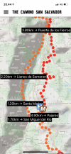
Don’t mean to be dense, but I don’t understand the map. Does the orange route stay on the other side of the valley?(by that I mean, does it stay up high rather than go down to San Miguel, across the river, and then back up again as the official route does?)
Where is this map from, it looks like a specific Salvador guide, but I haven’t seen it.
San Miguel comes after Pajares, not before as the labels suggest, unless this map is showing the split where you can go directly to San Miguel without going to Pajares. But it doesn’t look like it to me.
In any event, and like
@trecile has said, the question is where you will sleep.
The private albergue in Llanos de Somerón, which is highly reviewed, is on the official camino.
One way to go further than the 14.7 to Pajares would be to continue on the official route to Llanos, which would give you 5 more kms approximately.
If you wanted a 30 km day, go to Bendueños from Poladura. It is a wonderful place.
Good luck, wish I could understand the map better because I have walked the Salvador four times and have a pretty good idea of the route.


")