• Get your Camino Frances Guidebook here.
  • For 2024 Pilgrims: €50,- donation = 1 year with no ads on the forum + 90% off any 2024 Guide. More here.
    (Discount code sent to you by Private Message after your donation)
  • ⚠️ Emergency contact in Spain - Dial 112 and AlertCops app. More on this here.

Search 69,459 Camino Questions

App to find water on the Frances

isawtman

Active Member
Time of past OR future Camino
Camino Frances, 2022
Ice Age Trail, 2014, 2019
I just downloaded the Buen Camino App and I can't seem to find any listings for
water. The have points for Albergues, pilgrim masses, etc, but not places to get water.
Maybe I'm doing something wrong. I'm pretty sure there is a water spot
between Orisson and Roncevalles but I don't see it listed on the map.
Is there some other app that shows the water locations? Maybe it is my
backpacking background, but I am always interested on the location of the
next water stop.
 
Get a spanish phone number with Airalo. eSim, so no physical SIM card. Easy to use app to add more funds if needed.
The first edition came out in 2003 and has become the go-to-guide for many pilgrims over the years. It is shipping with a Pilgrim Passport (Credential) from the cathedral in Santiago de Compostela.
Ideal pocket guides for during & after your Camino. Each weighs only 1.4 oz (40g)!
I just downloaded the Buen Camino App and I can't seem to find any listings for
water. The have points for Albergues, pilgrim masses, etc, but not places to get water.
Maybe I'm doing something wrong. I'm pretty sure there is a water spot
between Orisson and Roncevalles but I don't see it listed on the map.
Is there some other app that shows the water locations? Maybe it is my
backpacking background, but I am always interested on the location of the
next water stop.
Brierley marks the Fontaine de Roland near the French/Spanish border. I would not expect to see it marked on any safety oriented app. If you are walking the Camino Frances then the reliable resources between St Jean and Roncesvalles are Orisson and, possibly, Borda. If you find yourself at the Fontaine de Roland with an empty water bottle you'll likely find yourself in trouble.

Many of the Camino guides mark the Fuente Reniega on the ascent to the Alto del Perdon. Anyone hoping for a drink from that fountain will be relying on the intervention of Santiago once again.

As a back-packer you'll know the basics - drink a litre before you start and carry two... And try to never arrive at a water source with a full bottle ;). Sitting, drinking and watching the world go by I have so often seen pilgrims arrive at a source, empty their full bottle, refill and walk on while never taking even a sip. I've assumed that, on the Camino Frances at least, they are so full of Coffee, Aquarias, Tinto de Verano and Estrella Dam that they've no room for water.
 
Is there some other app that shows the water locations?

Perhaps a better question would be which app uses underlying maps that show water points - like this one.

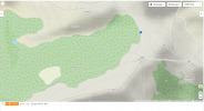
And yes there is a font on the Napoleon just off the route. And there are hundreds of water points on the Frances as shown on Open Street Map with the water points layer. Little blue tap.
 

Attachments

  • Roncevalles.png
    Roncevalles.png
    605.9 KB · Views: 49
I agree with everyone who said that there are plenty of places to get water on Frances. Honestly would not worry about it, save for the fact that keep an eye on your supply as it gets closer to Siesta Time! Staggering into some little village\hamlet at 3:00PM when everything is shut (and perhaps no other source is available) is no fun at all...

With all Respect Due to @Tincatinker I topped off my camelback at Fontaine de Roland and had no issues once so ever. I also ran into some folks who told me that they got water from fountains, faucets, et al that were not clearly marked "potable". I guess in the end it will come down on how strong one's inner system is - it may do nothing to one person and wreck digestive havoc to another....

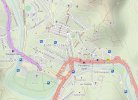
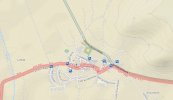
That said, here is a World Map OPenCycleMap - all you have to do is reasonably zero-in on any Camino section and look for a spigot\faucet icon.
Here are examples of Estrella and Tardajos areas:

Good Luck and Buen Camino
 

Attachments

  • Capture.JPG
    Capture.JPG
    107.2 KB · Views: 41
  • Capture2.JPG
    Capture2.JPG
    73.5 KB · Views: 41
€2,-/day will present your project to thousands of visitors each day. All interested in the Camino de Santiago.
I agree with everyone who said that there are plenty of places to get water on Frances. Honestly would not worry about it, save for the fact that keep an eye on your supply as it gets closer to Siesta Time! Staggering into some little village\hamlet at 3:00PM when everything is shut (and perhaps no other source is available) is no fun at all...

With all Respect Due to @Tincatinker I topped off my camelback at Fontaine de Roland and had no issues once so ever. I also ran into some folks who told me that they got water from fountains, faucets, et al that were not clearly marked "potable". I guess in the end it will come down on how strong one's inner system is - it may do nothing to one person and wreck digestive havoc to another....

That said, here is a World Map OPenCycleMap - all you have to do is reasonably zero-in on any Camino section and look for a spigot\faucet icon.
Here are examples of Estrella and Tardajos areas:

Good Luck and Buen Camino
The water at Fontaine de Roland was some of the sweetest I have tasted.
 
The last time I walked the Frances Napoleon route I recall drinking a litre before I started, carrying 1.5 litres, drinking at least one litre of that before Orrison and drinking another litre while taking a break there, refilling and continuing on to Roncesvalles with 1.5 litres. I don't remember if I filled up or where before I reached Roncesvalles.
 
Ideal pocket guides for during & after your Camino. Each weighs only 1.4 oz (40g)!
Brierley marks the Fontaine de Roland near the French/Spanish border. I would not expect to see it marked on any safety oriented app. If you are walking the Camino Frances then the reliable resources between St Jean and Roncesvalles are Orisson and, possibly, Borda. If you find yourself at the Fontaine de Roland with an empty water bottle you'll likely find yourself in trouble.

Many of the Camino guides mark the Fuente Reniega on the ascent to the Alto del Perdon. Anyone hoping for a drink from that fountain will be relying on the intervention of Santiago once again.

As a back-packer you'll know the basics - drink a litre before you start and carry two... And try to never arrive at a water source with a full bottle ;). Sitting, drinking and watching the world go by I have so often seen pilgrims arrive at a source, empty their full bottle, refill and walk on while never taking even a sip. I've assumed that, on the Camino Frances at least, they are so full of Coffee, Aquarias, Tinto de Verano and Estrella Dam that they've no room for water.
IMG_4912.JPG
 
Plenty of water en route. There are a few spots on the Meseta I might take a second bottle, but they are few and far between.
 
The focus is on reducing the risk of failure through being well prepared. 2nd ed.
Don't forget the cemeteries you pass by. They all have taps; for the flowers and the plants of course, but the water is also perfect for thirsty pilgrims ;)
 
Don't forget the cemeteries you pass by. They all have taps; for the flowers and the plants of course, but the water is also perfect for thirsty pilgrims ;)
The one and only time I tried water from a cemetery, it was contaminated with what tasted like kerosine. From memory, this was in France. This may have been a rare experience, but nevertheless be careful.
 
Is it just me? I am sad for the future of mankind when we have our faces so buried in our phones, that we cannot look up and see what is actually right in front of our faces. Surely I am not the only one who does not require an app of any kind to get through a day/week/month/year? Whatever happened to thinking, common sense, and being resourceful?
 
The 2024 Camino guides will be coming out little by little. Here is a collection of the ones that are out so far.
I just downloaded the Buen Camino App and I can't seem to find any listings for
water. The have points for Albergues, pilgrim masses, etc, but not places to get water.
Maybe I'm doing something wrong. I'm pretty sure there is a water spot
between Orisson and Roncevalles but I don't see it listed on the map.
Is there some other app that shows the water locations? Maybe it is my
backpacking background, but I am always interested on the location of the
next water stop.
few guidebooks (and possibly apps) list water sources. one comprehensive source is OSM (open street maps) which do have many taps indicated on their maps, but sometimes this info is outdated - for example, I haven't seen a water tap in Ganecoleta on the valley route to Roncesvalles.

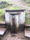
there is fuente de roldan between orisson and roncesvalles, but in this hot summer it may be dry. the food truck shortly before the camino goes off road has bottled water.

usually there is at least one spot with drinkable water in every village on camino frances. this could be a water tap linked to the water system, or a fountain linked to a proper water source. these later are usually marked as 'sin guarantia sanitaria' which means they are not regulated or checked. in my mind, that means the best kind of water, directly from the source, used for centuries. the only ones I don't drink are if they smell weird or if the output leaves orange colour (that means it's very likely sulphuric and I don't fancy rotten eggs very much).

I always take special care to look at water sources in advance. OSM is my primary source, then verifying that with google maps.
 
Is it just me? I am sad for the future of mankind when we have our faces so buried in our phones, that we cannot look up and see what is actually right in front of our faces. Surely I am not the only one who does not require an app of any kind to get through a day/week/month/year? Whatever happened to thinking, common sense, and being resourceful?
Nothing wrong with using an app instead of a guidebook for the Camino. It's important, especially in summer to know how much water one needs to carry, and where to find places to refill. In fact it's common sense to anticipate such things.

I don't think that you would have such a reaction if the question had been which guidebook shows water sources in the Camino.
 

Most read last week in this forum

To me the most Dangerous stage on the Camino Frances was from Foncebadon to Ponferrada in the rain. Never forget the riverbed rocks from El Acebo to Ponferrada totally treacherous, seen several...
...I am on day eight of walking the Francés at the moment. It is quite busy. A lot of talk about beds (and the need to book ahead). I don't book. Today I tried really hard not to get a bed. I...
I started from Pamplona this morning for a quick week walking before starting service as a hospitalera next week back in Pamplona. The trail up to Alto de Perdón has only a few big puddles left...
I’m heading to the Frances shortly and was going to be a bit spontaneous with rooms. I booked the first week just to make sure and was surprised at how tight reservations were. As I started making...
Ultreia, y'all! I am excited to start my first camino soon and have a question about the first time I use my Pilgrim's Passport. I have one already (purchased from Ivar) but was still planning to...
Hello, I would be grateful for some advice from the ones of you who are walking/have recently walked from SJPdP :) 1 - How busy is the first part of the camino right now? I read some reports of a...

❓How to ask a question

How to post a new question on the Camino Forum.

Forum Rules

Forum Rules

Camino Updates on YouTube

Camino Conversations

Most downloaded Resources

This site is run by Ivar at

in Santiago de Compostela.
This site participates in the Amazon Affiliate program, designed to provide a means for Ivar to earn fees by linking to Amazon
Official Camino Passport (Credential) | 2024 Camino Guides
Back
Top