Duncan Idaho
Member
- Time of past OR future Camino
- Camino Frances 2014, Portuguese 2015, Finisterre 2015, Norte 2017, Aragones 2018, V d Plata 2019
Hi All,
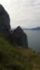
Am booked up and starting the Norte from Irun in mid-April. I have trawled around previous threads looking for posts on sections that might be prone to be muddy but have read some comments suggesting some sections were considered downright dangerous ?
I'm fit, healthy, wont be carrying too much weight and am planning to average around 25km a day. Am looking forward to the scenery and challenge but not so much that I want to risk slipping up in the mud and falling over a cliff !
Are my concerns misplaced are there some sections (particuarly between Irun and Santander) that looking back people would not do again or take the long way around ? Or sections if particularly muddy would make you think not so much?
Thanks ever for any helpm
Duncan