
-
For 2024 Pilgrims: €50,- donation = 1 year with no ads on the forum + 90% off any 2024 Guide. More here.
(Discount code sent to you by Private Message after your donation) -
 ⚠️ Emergency contact in Spain - Dial 112 and AlertCops app. More on this here.
Search 69,459 Camino Questions
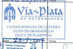
Arrows on the VdlP
- Thread starter El Muto
- Start date

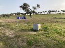


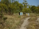
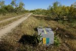
") The direction marker on top using the Caparra arch is very helpful except where some vandal has toppled the cube into a ditch
The direction marker on top using the Caparra arch is very helpful except where some vandal has toppled the cube into a ditch 


❓How to ask a question
How to post a new question on the Camino Forum.
Similar threads
-

-
 Dinner time on the VDLP
- Started by JustJack
- Replies: 31
-
Christmas and New Year on the VdlP
- Started by limescene
- Replies: 2
-

-
Forum Rules

Camino Updates on YouTube

Most downloaded Resources
-
 “All” Albergues on the Camino Frances in one pdf“All” Albergues on the Camino Frances in one pdf
- ivar
- Updated:
-
 A selection of favorite albergues on the Camino FrancésFavorite Albergues along the Camino Frances
- Ton van Tilburg
- Updated:
-
 Profile maps of all 34 stages of the Camino FrancesProfile maps of all 34 stages of the Camino Frances
- ivar
- Updated: