
-
For 2024 Pilgrims: €50,- donation = 1 year with no ads on the forum + 90% off any 2024 Guide. More here.
(Discount code sent to you by Private Message after your donation)
Search 69,459 Camino Questions
You are using an out of date browser. It may not display this or other websites correctly.
You should upgrade or use an alternative browser.
You should upgrade or use an alternative browser.
Biking from Porto - Eurovelo or Camino path?
- Thread starter dogtails
- Start date

3rd Edition. More content, training & pack guides avoid common mistakes, bed bugs etc
- Time of past OR future Camino
- 2012
You could try comparing the two here: https://euroveloportugal.com/en/ and here: https://www.gronze.com/etapa/porto/vilarinho
As a walker I'd be inclined to encourage you on to the Eurovelo") Are you intending to reach Santiago and claim a Compostella or are you just up for the ride?
Are you intending to reach Santiago and claim a Compostella or are you just up for the ride?
As a walker I'd be inclined to encourage you on to the Eurovelo
Are you intending to reach Santiago and claim a Compostella or are you just up for the ride?Gerard Griffin
Active Member
I'd recommend the Coastal Camino. It's safer than the Eurovelo route because there's less road and more trail, it's flat, and it's beautiful to cycle on the boardwalk beside the sea.
Spain has generous margins for road cyclists. Portugal doesn't. Spanish drivers respect the 1.5 meter bike clearance rule. Less so the more anarchic Portuguese, including truck-drivers. With kids the Eurovelo route is, in my opinion, best avoided.
Ignore the bleatings of walkers who want this lovely trail all to themselves ...
3rd Edition. More content, training & pack guides avoid common mistakes, bed bugs etc
stevewarne
New Member
- Time of past OR future Camino
- Portugal Coastal Camino (2022)
My girlfriend and I finished 6 days of cycling from Porto to Santiago in June. Before the trip, I spent months researching which route to take and looking at various GPS tracks. We wanted to stay close to the ocean, and avoid hills and traffic.Hi! I‘m biking with my husband and two teens from Porto and I’m curious if you would recommend the Eurovelo coastal route or the Camino route? or other route suggestions? When we get into Spain we plan to go via Vigo.
We looked at Eurovelo 1, Section 17 & 18, which will take you from Porto to Caminha (it ends in Portugal), but found it had issues. It takes you on boardwalks that don’t allow bikes, puts you on some busy highways (e.g., the N-13), has you going the wrong way down one-way streets. But most importantly, the Eurovelo route hasn’t been updated for all the new bike paths along the ocean that Portugal has invested in. So, in Portugal, we ended up creating a track that used a combination of Eurovelo 1 (with fixes) and the unofficial Senda Litoral route.
In some cases, I contacted local tourist offices to find the best routes in Portugal. For instance, in an area below Viana do Castelo, they gave me a route suggestion that avoided a sandy beach area that they said was not passable by bike. I also got a suggestion to take a ferry across the river Limia to avoid a terrible bridge (for bikers, that is). Our route worked well for us except on the second day, we got into some sandy beach areas near Marinhas that were a struggle to get our bikes through.
I found the route planning for Spain much easier. Going to Baiona was a matter of following the bike route along the N-550 highway by the ocean which was pretty well marked. From Baiona to Vigo, there are route variations, but for cyclists, the easiest is to stay along the ocean from the start, and then go through the beautiful parks along the Rio Lagares in Vigo. With the right route, you only have about 1.5 miles of street riding through Vigo.
From Vigo to Redondela, and then on to Pontevedra, Caldas de Reis, Padron and Santiago, you just follow the markers, or follow the walkers, as there is really only one route. We looked at some route variations that avoid short sections of rough dirt paths, but really, it's just easier to follow the marked walker route.
If you are savy in working with GPS, I can provide our actual GPX tracks from our trip that I used on a Garmin Edge 530 unit. It's 6 files, but I'm not sure what the rules are for attaching the files here.
dogtails
New Member
- Time of past OR future Camino
- Camino del Santiago
Thank you! We’ve mixed and matched the EV1 with the Camino in Portugal and also found stretches of the EV not viable at all. We had a few hike a bikes to get thru the sand and rock and also ended up on N13 for a short bit. You were wise to avoid the bridge across Limia! That was a bit scary pulling a small trailer and also w two teens. The views along the coast have been stunning!My girlfriend and I finished 6 days of cycling from Porto to Santiago in June. Before the trip, I spent months researching which route to take and looking at various GPS tracks. We wanted to stay close to the ocean, and avoid hills and traffic.
We looked at Eurovelo 1, Section 17 & 18, which will take you from Porto to Caminha (it ends in Portugal), but found it had issues. It takes you on boardwalks that don’t allow bikes, puts you on some busy highways (e.g., the N-13), has you going the wrong way down one-way streets. But most importantly, the Eurovelo route hasn’t been updated for all the new bike paths along the ocean that Portugal has invested in. So, in Portugal, we ended up creating a track that used a combination of Eurovelo 1 (with fixes) and the unofficial Senda Litoral route.
In some cases, I contacted local tourist offices to find the best routes in Portugal. For instance, in an area below Viana do Castelo, they gave me a route suggestion that avoided a sandy beach area that they said was not passable by bike. I also got a suggestion to take a ferry across the river Limia to avoid a terrible bridge (for bikers, that is). Our route worked well for us except on the second day, we got into some sandy beach areas near Marinhas that were a struggle to get our bikes through.
I found the route planning for Spain much easier. Going to Baiona was a matter of following the bike route along the N-550 highway by the ocean which was pretty well marked. From Baiona to Vigo, there are route variations, but for cyclists, the easiest is to stay along the ocean from the start, and then go through the beautiful parks along the Rio Lagares in Vigo. With the right route, you only have about 1.5 miles of street riding through Vigo.
From Vigo to Redondela, and then on to Pontevedra, Caldas de Reis, Padron and Santiago, you just follow the markers, or follow the walkers, as there is really only one route. We looked at some route variations that avoid short sections of rough dirt paths, but really, it's just easier to follow the marked walker route.
If you are savy in working with GPS, I can provide our actual GPX tracks from our trip that I used on a Garmin Edge 530 unit. It's 6 files, but I'm not sure what the rules are for attaching the files here.
We’ll hit the hills after Vigo in two days. Are they as hard as the GPX show? thanks for your helpful suggestions!
dogtails
New Member
- Time of past OR future Camino
- Camino del Santiago
Thank you! we’ve switched back and forth at times based on the GPX And you are right the views are beautiful! We like the Camino better for the most part and the walkers have been so wonderful! We’ve enjoyed chatting w them at rests and most people seem very generous and friendly!I'd recommend the Coastal Camino. It's safer than the Eurovelo route because there's less road and more trail, it's flat, and it's beautiful to cycle on the boardwalk beside the sea.
Spain has generous margins for road cyclists. Portugal doesn't. Spanish drivers respect the 1.5 meter bike clearance rule. Less so the more anarchic Portuguese, including truck-drivers. With kids the Eurovelo route is, in my opinion, best avoided.
Ignore the bleatings of walkers who want this lovely trail all to themselves ...

Join our full-service guided tour of the Basque Country and let us pamper you!
stevewarne
New Member
- Time of past OR future Camino
- Portugal Coastal Camino (2022)
I thought the views were amazing too. It was really the most scenic bike tour we've done, and I'd love to go back and do it again. But next time, we'd slow it down and spend a day or two in each of the cities along the way.Thank you! We’ve mixed and matched the EV1 with the Camino in Portugal and also found stretches of the EV not viable at all. We had a few hike a bikes to get thru the sand and rock and also ended up on N13 for a short bit. You were wise to avoid the bridge across Limia! That was a bit scary pulling a small trailer and also w two teens. The views along the coast have been stunning!
We’ll hit the hills after Vigo in two days. Are they as hard as the GPX show? thanks for your helpful suggestions!
There is a big hill coming out of Vigo that takes you up to a ridgeline with beautiful views of the bay below. It's a short hill and walkable. Then it's almost all downhill into Redondela.
I'm glad to hear someone else appreciates the ride as much as we did. Have fun and good luck.
Oh, one other thing. If you haven't gotten to Spain yet. You can take a private ferry from Caminha to Spain instead of the public one. The private ferry (WhatsApp to Miguel at 351 913 254 110 to schedule it) drops you and your bikes on the beach across the river. You then walk about 100 ft to a boardwalk that goes around the penninsula to A Guarda. It's a beautiful ride and it avoids the street riding that you have to do if you take the big ferry.
dogtails
New Member
- Time of past OR future Camino
- Camino del Santiago
thanks! We took the private ferry and it was worth it! Got a few flat tires riding through Oia where there seems to be lots of thorny bushes. What route did you take out of Vigo? I’m hoping for a not steep climb!I thought the views were amazing too. It was really the most scenic bike tour we've done, and I'd love to go back and do it again. But next time, we'd slow it down and spend a day or two in each of the cities along the way.
There is a big hill coming out of Vigo that takes you up to a ridgeline with beautiful views of the bay below. It's a short hill and walkable. Then it's almost all downhill into Redondela.
I'm glad to hear someone else appreciates the ride as much as we did. Have fun and good luck.
Oh, one other thing. If you haven't gotten to Spain yet. You can take a private ferry from Caminha to Spain instead of the public one. The private ferry (WhatsApp to Miguel at 351 913 254 110 to schedule it) drops you and your bikes on the beach across the river. You then walk about 100 ft to a boardwalk that goes around the penninsula to A Guarda. It's a beautiful ride and it avoids the street riding that you have to do if you take the big ferry.
stevewarne
New Member
- Time of past OR future Camino
- Portugal Coastal Camino (2022)
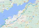
I've attached the GPX file of the route we took, a JPEG file, and below is a link to the Google Map of our track. There is a steep climb, but it doesn't last long and we walked it. Vigo was a lot better than we thought it would be. We stopped at Coffee Runners Cafe. That was nice. Also, when in doubt about safety, ride on the side walks . . .might be illegal, but nobody cares. I'd love to hear how it goes for youthanks! We took the private ferry and it was worth it! Got a few flat tires riding through Oia where there seems to be lots of thorny bushes. What route did you take out of Vigo? I’m hoping for a not steep climb!
https://www.google.com/maps/d/edit?...&ll=42.19889143203119,-8.727293506594947&z=12
Attachments

The 2024 Camino guides will be coming out little by little. Here is a collection of the ones that are out so far.
dogtails
New Member
- Time of past OR future Camino
- Camino del Santiago
Thank you! and one more question… how hard were the last 10 miles or so into Santiago de Compostela that are nearly all up hill? Asking for two teensI've attached the GPX file of the route we took, a JPEG file, and below is a link to the Google Map of our track. There is a steep climb, but it doesn't last long and we walked it. Vigo was a lot better than we thought it would be. We stopped at Coffee Runners Cafe. That was nice. Also, when in doubt about safety, ride on the side walks . . .might be illegal, but nobody cares. I'd love to hear how it goes for you
https://www.google.com/maps/d/edit?hl=en&hl=en&mid=1A7FIEjbZ8Hv0NlrrtXLtEgn7rW21jFQ&ll=42.19889143203119,-8.727293506594947&z=12

stevewarne
New Member
- Time of past OR future Camino
- Portugal Coastal Camino (2022)
Thank you! and one more question… how hard were the last 10 miles or so into Santiago de Compostela that are nearly all up hill? Asking for two teens
For us, even with the rain, it didn't seem too hard because it was a short day. It's about a 5 mile section in the middle between Padron and Santiago that is hilly. Also, some rough and rocky paths where even a good cyclist has to get off and walk. I think if you and the teens made it that far, you'll do great at the end, especially knowing you are almost done.Thank you! and one more question… how hard were the last 10 miles or so into Santiago de Compostela that are nearly all up hill? Asking for two teens
Corned Beef
Veteran Member
- Time of past OR future Camino
- 2024 Portuguese/ VF (South) / VF Grand St Bernard
At the 5 miles to go section, you may need to walk. There will be more walkers on some rather narrow paths and the road options may not appeal as they're busy too.
There is a rail station at Osebe but it seems to be the usual one-train-a-day station. Or there are far more options with Padron. (You need the Regional Express or Media Distancia trains)
As @stevewarne suggests, the arrival is worth the walk/ride but the rail option is there if they need it.
There is a rail station at Osebe but it seems to be the usual one-train-a-day station. Or there are far more options with Padron. (You need the Regional Express or Media Distancia trains)
As @stevewarne suggests, the arrival is worth the walk/ride but the rail option is there if they need it.

The 9th edition the Lightfoot Guide will let you complete the journey your way.
Hi there.. We are looking at this in early October next year. Would very much like to access your files. How can we do that?My girlfriend and I finished 6 days of cycling from Porto to Santiago in June. Before the trip, I spent months researching which route to take and looking at various GPS tracks. We wanted to stay close to the ocean, and avoid hills and traffic.
We looked at Eurovelo 1, Section 17 & 18, which will take you from Porto to Caminha (it ends in Portugal), but found it had issues. It takes you on boardwalks that don’t allow bikes, puts you on some busy highways (e.g., the N-13), has you going the wrong way down one-way streets. But most importantly, the Eurovelo route hasn’t been updated for all the new bike paths along the ocean that Portugal has invested in. So, in Portugal, we ended up creating a track that used a combination of Eurovelo 1 (with fixes) and the unofficial Senda Litoral route.
In some cases, I contacted local tourist offices to find the best routes in Portugal. For instance, in an area below Viana do Castelo, they gave me a route suggestion that avoided a sandy beach area that they said was not passable by bike. I also got a suggestion to take a ferry across the river Limia to avoid a terrible bridge (for bikers, that is). Our route worked well for us except on the second day, we got into some sandy beach areas near Marinhas that were a struggle to get our bikes through.
I found the route planning for Spain much easier. Going to Baiona was a matter of following the bike route along the N-550 highway by the ocean which was pretty well marked. From Baiona to Vigo, there are route variations, but for cyclists, the easiest is to stay along the ocean from the start, and then go through the beautiful parks along the Rio Lagares in Vigo. With the right route, you only have about 1.5 miles of street riding through Vigo.
From Vigo to Redondela, and then on to Pontevedra, Caldas de Reis, Padron and Santiago, you just follow the markers, or follow the walkers, as there is really only one route. We looked at some route variations that avoid short sections of rough dirt paths, but really, it's just easier to follow the marked walker route.
If you are savy in working with GPS, I can provide our actual GPX tracks from our trip that I used on a Garmin Edge 530 unit. It's 6 files, but I'm not sure what the rules are for attaching the files here.
stevewarne
New Member
- Time of past OR future Camino
- Portugal Coastal Camino (2022)
I'll send them as attachments. I've done that for others and it seems to work OK. They are GPX tracks . . .six files, one for each day of the trip. I'm in the middle of something now, but look for a message tomorrow. Thanks.Hi there.. We are looking at this in early October next year. Would very much like to access your files. How can we do that?
stevewarne
New Member
- Time of past OR future Camino
- Portugal Coastal Camino (2022)
Hi there.. We are looking at this in early October next year. Would very much like to access your files. How can we do that?
Attachments
-
Day-01 Porto to Esposende.gpx583.6 KB · Views: 45
-
Day-02 Esposende to Camimha.gpx428.5 KB · Views: 14
-
Day-03 Caminha to Baiona.gpx592.6 KB · Views: 14
-
Day-04 Baiona to Pontevedra.gpx787.7 KB · Views: 14
-
Day-05 Pontevedra to Padron.gpx714.3 KB · Views: 14
-
Day-06 Padron to Santiago.gpx488.2 KB · Views: 13

St James' Way - Self-guided 4-7 day Walking Packages, Reading to Southampton, 110 kms
BobbyJ
New Member
- Time of past OR future Camino
- October 2023
Hi, I am starting my plans to do the Porto to Santiago bike ride by myself in late October and will be using your route. Thank you btw for sharing it. Are there obstacles I might encounter, like the rocky uphill part I see in almost all videos? Everyone is seen pushing their bikes up an incline. Is there a different path I can take to bypass that part? If none then so be it. I am also planning to skip going to Padron and going straight to Santiago as I don't have that much time. Any insight would be great. I'm so glad I found this forum.
stevewarne
New Member
- Time of past OR future Camino
- Portugal Coastal Camino (2022)
There is a short rocky area from Redondela to Pontevedra, and another similar short spot from Padron to SdC. We walked our bikes through these and it was not an issue. There could be bypasses for cyclists, but I'm not aware of them. I have attached a RideWithGPS file that someone recorded. It shows some deviations from my Padron to SdC route which may be intended to avoid those rocky areas. You could research these deviations and maybe come up with a better route.
Also, a little ways after Esposende you need to turn right and go inland on Rua da Praia de Rio de Moinhos (long name) to the N13 highway to avoid the sand dunes. The GPX files show the corrected track. We made the mistake of continuing along the beach and the path just disappeared into sand dunes. It made for a tough day.
I can't think of any other significant obstacles. Some bridges are a pain because they are narrow with lots of traffic, but cars/trucks seem respectful of cyclists. If you are not in too much of a hurry, you can avoid the bridge in Viana do Castelo and take the water ferry across the Limia river. Check with the town tourist office to make sure it's running in September. Hope this helps. I'm planning on doing this Camino again, so if you come up with some changes for a better route, please publish them here.
Attachments
stevewarne
New Member
- Time of past OR future Camino
- Portugal Coastal Camino (2022)
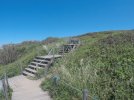
I was just reminded of some issues along the boardwalks in Portugal. In some areas you will encounter steps (see picture). Not a problem if you are using a luggage-forward service, but with a full pack it could be tough. Also, there are areas where sand drifts cover the boardwalk and it virtually disappears for several hundred feet. We saw that just below Ancora. And (last one) at 6.6 miles out of Baiona at Praia de Prado, the track takes you onto the beach for a very short distance. Which is OK except that you have to hike your bike over rocks to get back up to the road. I didn't think any of the above was a big issue but my wife thought I should do full disclosure.
Attachments

Technical backpack for day trips with backpack cover and internal compartment for the hydration bladder. Ideal daypack for excursions where we need a medium capacity backpack. The back with Air Flow System creates large air channels that will keep our back as cool as possible.
€83,-
€83,-
BobbyJ
New Member
- Time of past OR future Camino
- October 2023
Wow so many routes to choose from. Thank you very much for all the information. I will definitely take them into consideration. Specially the rocky areas.There is a short rocky area from Redondela to Pontevedra, and another similar short spot from Padron to SdC. We walked our bikes through these and it was not an issue. There could be bypasses for cyclists, but I'm not aware of them. I have attached a RideWithGPS file that someone recorded. It shows some deviations from my Padron to SdC route which may be intended to avoid those rocky areas. You could research these deviations and maybe come up with a better route.
Also, a little ways after Esposende you need to turn right and go inland on Rua da Praia de Rio de Moinhos (long name) to the N13 highway to avoid the sand dunes. The GPX files show the corrected track. We made the mistake of continuing along the beach and the path just disappeared into sand dunes. It made for a tough day.
I can't think of any other significant obstacles. Some bridges are a pain because they are narrow with lots of traffic, but cars/trucks seem respectful of cyclists. If you are not in too much of a hurry, you can avoid the bridge in Viana do Castelo and take the water ferry across the Limia river. Check with the town tourist office to make sure it's running in September. Hope this helps. I'm planning on doing this Camino again, so if you come up with some changes for a better route, please publish them here.
BobbyJ
New Member
- Time of past OR future Camino
- October 2023
Wow!! This is scary and thanks for letting me know as I would keep an eye out for this for sure.I was just reminded of some issues along the boardwalks in Portugal. In some areas you will encounter steps (see picture). Not a problem if you are using a luggage-forward service, but with a full pack it could be tough. Also, there are areas where sand drifts cover the boardwalk and it virtually disappears for several hundred feet. We saw that just below Ancora. And (last one) at 6.6 miles out of Baiona at Praia de Prado, the track takes you onto the beach for a very short distance. Which is OK except that you have to hike your bike over rocks to get back up to the road. I didn't think any of the above was a big issue but my wife thought I should do full disclosure.


Most read last week in this forum
I Willl start biking from SJPD on 9.may with Ebike. I have a list of bike friendly albergs is there somebody who have experience with charging batery in such alberg. Do i need afdition 220v...
Similar threads
- Replies
- 18
- Views
- 2K
❓How to ask a question
How to post a new question on the Camino Forum.
Latest posts
-
 Crazy! 😝 That is what we were told...
- Latest: everyday.journeys
-

Similar threads
-
-
E-Bike on a train from Santiago de Compostela to Porto
- Started by Eben Jacobs
- Replies: 18
-
-
Forum Rules

Camino Updates on YouTube

Most downloaded Resources
-
 “All” Albergues on the Camino Frances in one pdf“All” Albergues on the Camino Frances in one pdf
- ivar
- Updated:
-
 A selection of favorite albergues on the Camino FrancésFavorite Albergues along the Camino Frances
- Ton van Tilburg
- Updated:
-
 Profile maps of all 34 stages of the Camino FrancesProfile maps of all 34 stages of the Camino Frances
- ivar
- Updated: