geraldkelly
Active Member
- Time of past OR future Camino
- Camino Francés, Vía de la Plata / Camino Sanabrés, Camino del Baztán, Camino Aragonés, Chemin du Puy
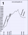
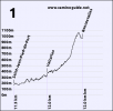
Everybody seems to assume that the route through Valcarlos is easier because its highest point (1057m) is lower than the highest point on the Napoleonic route (1427m).
While preparing the new version of my app I was recalculating the total ascent and descent on both these routes. This is calculated by taking the difference in altitude between each GPS point along the route and adding all the ascents and all the descents together, that way you get the real amount of climbing and descending involved, not just the change of altitude from one village to the next.
I discovered something I didn’t expect to find but which I had suspected having walked both of these routes several times. The Valcarlos route actually involves more climbing than the Napoleonic route despite being lower altitude.
Some stats
Napoleonic route: total ascent = 1465m, total descent = -695m
Valcarlos route: total ascent = 1530m, total descent = -758m
The difference between the two routes isn’t huge but it’s significant given that the Valcarlos route is usually described as the easier option. But actually it’s not that simple.
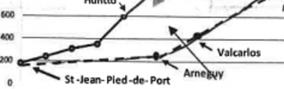
The key to this is the part from Saint-Jean to Valcarlos. This starts at 174m and ends at 366m. That makes a difference of 192m over 11.5km. So, 16m per km. It sounds pretty flat and I have to admit that in the past I’ve described it as being exactly that, pretty flat. But the reality is different, it actually ascents 529m and descends 337m. So it’s not flat at all but you tend not to notice it because it’s several small ascents and descents and you’ll usually walking it at the start of the day when you’re fresh and by the time you arrive into Roncesvalles at the end of the day you’re so exhausted from the climb that comes later in the day that you’ve completely forgotten when you did in the morning.
I'm attaching altitude profiles for both routes so you can see for yourself.
You can verify the figures above by calculating as follows: Saint-Jean altitude = 174m, Roncesvalles = 944m
174+1465-695 = 944
174+1530-758 = 946
(small difference due to the GPS track not being 100% accurate)
While preparing the new version of my app I was recalculating the total ascent and descent on both these routes. This is calculated by taking the difference in altitude between each GPS point along the route and adding all the ascents and all the descents together, that way you get the real amount of climbing and descending involved, not just the change of altitude from one village to the next.
I discovered something I didn’t expect to find but which I had suspected having walked both of these routes several times. The Valcarlos route actually involves more climbing than the Napoleonic route despite being lower altitude.
Some stats
Napoleonic route: total ascent = 1465m, total descent = -695m
Valcarlos route: total ascent = 1530m, total descent = -758m
The difference between the two routes isn’t huge but it’s significant given that the Valcarlos route is usually described as the easier option. But actually it’s not that simple.
The key to this is the part from Saint-Jean to Valcarlos. This starts at 174m and ends at 366m. That makes a difference of 192m over 11.5km. So, 16m per km. It sounds pretty flat and I have to admit that in the past I’ve described it as being exactly that, pretty flat. But the reality is different, it actually ascents 529m and descends 337m. So it’s not flat at all but you tend not to notice it because it’s several small ascents and descents and you’ll usually walking it at the start of the day when you’re fresh and by the time you arrive into Roncesvalles at the end of the day you’re so exhausted from the climb that comes later in the day that you’ve completely forgotten when you did in the morning.
I'm attaching altitude profiles for both routes so you can see for yourself.
You can verify the figures above by calculating as follows: Saint-Jean altitude = 174m, Roncesvalles = 944m
174+1465-695 = 944
174+1530-758 = 946
(small difference due to the GPS track not being 100% accurate)


")


 They said they didn’t think they went the wrong way as they had followed the