Search 69,459 Camino Questions

Camino de Invierno + Route of Sil viewpoints

carlostorresdarder

New Member
Time of past OR future Camino
Francés
Aragonés
Primitivo
Vía Tolosana
Sanabrés
Norte
Le Puy
Remarkables Pilgrims,

In mid-May we will do the Camino de Invierno. I am evaluating the possibility of taking a day off in Monforte, and renting a car to do the route of the Sil viewpoints through the Ribera Sacra. Which has magnificent views and good vineyards on the Sil

Although in reality, what I would like to do is leave the path at some point near A Rua de Valdeorras, to continue walking along the route of the viewpoints and link up again with the "official path" in Monforte. Probably, this adds one or two extra days of Camino than the official route that goes through Quiroga. I assume that this path is not marked and that the route will have to be studied a bit. search for accommodation in hotels, ect... I'm also looking at wikiloc.

Somebody made it?
All ideas and comments are welcome.
Thanks
Carlos
 
The one from Galicia (the round) and the one from Castilla & Leon. Individually numbered and made by the same people that make the ones you see on your walk.
The Invierno from A Rúa to Soldón has views of the Sil most of the way, and there is a little Sil walking between Quiroga and SanClodio.

IMO, the really spectacular parts of the Sil are not between Quiroga and Monforte but rather south and west of Monforte, loosely towards Ourense. I have visited the Cañones del Sil, as a tourist, roughly between the Monastery of Santo Estevo de Ribas de Sil and Parada de Sil. That is the most popular part of the Sil River Gorge, I think, but it is all beautiful. There are amazing romanesque churches to visit, and I have done some walking there between churches.

I don’t know if you will find a path along the river, but one option to consider would be to get a car in Monforte and take off for a couple of days. Stay at the parador, it is amazing, and use it as your base to travel.

I’m pasting in a summary of how I spent one day on the Sil Gorge, you will see there was some walking, but not a continuous point to point. It was an absolutely beautiful day.

Saturday, I left the parador by 9:00. First stop was San Pedro de Rocas, a Romanesque church built into the rocks and then used as tombs, many anthropomorphic shapes in the lower levels. I walked a great 9 km circle, which involved seeing a peto de ánimas, one of those old stone structures where people used to deposit alms for the souls in Purgatory. After visiting the church, I drove to Parada de Sil and the church of Santa Cristina. WOW, this is a lovely place, down in a little woods near the river clinging to the side of the mountain. Another Romanesque, beautiful entrance to the cloister, then a bigger church adjacent. Just an idyllic setting.

Because there was an orienteering race going on, no cars were allowed into Parada de Sil, so my walking plans around there were going to have to change. So I drove past Parada de Sil and found a trailhead that was about 3 km from the Balcons de Madrid. Lovely lovely walk out to the view point, through a couple of hamlets and lots of forest. The views from the two different miradors are just amazing, looking down onto the Sil River gorge.

From there I drove back slowly to the parador, stopping at 3 or 4 miradores along the river. One view was lovelier than the next, it was very nice. When I got back to the parador, with many hours of daylight left, I decided to walk on a well marked trail up to the hamlet of Pombar, about 2.5 km up from the parador, and then back down. More gorgeous views. Through lots of lovely woods, and I was accompanied by a black dog the whole way there.

 
€2,-/day will present your project to thousands of visitors each day. All interested in the Camino de Santiago.
I have not walked the Invierno but have visited the Canyon de Sil as a tourist. It is a beautiful area, the parador is lovely and there was at the time a catamaran trip that took you east along the Sil to view some inaccessible parts of the canyon.

https://goo.gl/maps/NxfN54h9FbQHavzE9

 
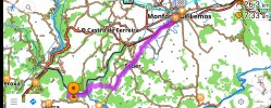
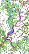
Playing around with maps, here's a variant I came up with, instead of walking from Monforte to the CR at Torre Vilariño direct, to go vis San Estevo:

Monforte - Santo Estevo de Ribas de Sil - Torre Vilariño
1. Monforte - San Estevo 26.3km
20220216_010009.jpg
2. San Estevo - Torre Vilarino 24.5km
20220216_010038.jpg
I have no idea how it would actually be on the ground. But it looks possible in theory, without monster stages.

The biggest downside? Lots of road walking.
It would add a day (or two if you were not planning to stop in Torre Vilariño) to the camino, but wow...it sure looks worth it!
 
New Original Camino Gear Designed Especially with The Modern Peregrino In Mind!

Most read last week in this forum

We’re scoping out accommodation on the Invierno, and @C clearly noticed that Pensión As Viñas is on booking. There is an annotation “new to booking.” Many of us stayed there before the albergue...

❓How to ask a question

How to post a new question on the Camino Forum.

Forum Rules

Forum Rules

Camino Updates on YouTube

Camino Conversations

Most downloaded Resources

This site is run by Ivar at

in Santiago de Compostela.
This site participates in the Amazon Affiliate program, designed to provide a means for Ivar to earn fees by linking to Amazon
Official Camino Passport (Credential) | 2024 Camino Guides
Back
Top