• For 2024 Pilgrims: €50,- donation = 1 year with no ads on the forum + 90% off any 2024 Guide. More here.
    (Discount code sent to you by Private Message after your donation)
  • ⚠️ Emergency contact in Spain - Dial 112 and AlertCops app. More on this here.

Search 69,459 Camino Questions

Camino de Pennine Way! And we're off .....

Undermanager

Active Member
Time of past OR future Camino
Madrid (x2)
VDLP
Salvador
Primitivo
Finisterra / Muxia
Lana
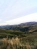
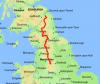
Is it okay to post daily musings here for the Pennine Way, an approximately 18 day 430 km walk from Edale in England to Kirk Yetholm in Scotland, going over lots of small mountains and moorland, with great scenery and notorious wild weather? If it's not, just remove the thread.

Starting Thursday 22nd August from Edale, the plan is to mix camping with hostels and maybe the odd pub. Camp sites are frequent but many 'wild camp', not strictly legal in England but tolerated in the higher areas as long as you arrive late, leave early and leave nothing but thanks. Hostels are available on day 1 and then again on day 4 and on each day afterwards, but they are not as frequent as you might like making for some long walks and certainly most of the time, there is only one hostel to choose from - booking is advisable. Prices range from £10 - £20 for an albergue-style bed in a hostel. Hotels, pubs and b&bs are also along the way but can be limited and are usually much more expensive than the equivalent in Spain - starting at around £40 a night but often much more.

The routes can be found on two Harvey maps, Pennine Way South and North XT40, and you need a compass as well as a GPS route, ideally on a proper GPS unit rather than a phone; the weather is often terrible and visibility is frequently pea-soup so the ability to navigate safely is a must. People sadly do die on the route because they often underestimate the weather.

The forecast is looking promising, but you can never be sure with the Pennines. The rucksack is a bit heavier than the 8kg I'd take on a Camino at 11kg because of the need for a tent, heavier sleeping bag for the potentially cold weather and a sleeping air mat but should be just about okay - we shall see as my bones are not what they were. Some compromises have been made; I'm not carrying any cooking equipment but there are enough places to eat and shop so won't starve. Not taking gaiters or leather boots - just accepting the bog and mud using trail shoes! I'm planning to carry a litre of water and a filter for more when I find it.

That's just about it. Sheffield tomorrow to stay with friends, then Edale on Thursday and off we go. I will try to post enough info to help anyone thinking of doing something similar themselves. Any questions, please ask.
 

Attachments

  • Screenshot 2019-08-16 at 22.49.52.png
    Screenshot 2019-08-16 at 22.49.52.png
    177.7 KB · Views: 31
Last edited:
St James' Way - Self-guided 4-7 day Walking Packages, Reading to Southampton, 110 kms
What an adventure! I'm looking forward to reading your posts.
In July I walked 3 weeks in Scotland and it was fabulous! I would like to do the Pennine Way or another long distance walk in England some time and it will be great to read your updates. I did some wild camping in Scotland but as you mention in your post, it is not legal to wild camp in England, so I'm curious how you are going to manage wild camping.
All the best to you.
 
I walked it about five years ago, and like you my pack was much heavier,, That and the amount of walking on hard surface left me with sore feet for a couple of months after. But on the bright side I did get my free half pint of beer in Kirk Yetholm. Good luck, and enjoy. :)
 
Ideal pocket guides for during & after your Camino. Each weighs only 1.4 oz (40g)!
I walked it about five years ago, and like you my pack was much heavier,, That and the amount of walking on hard surface left me with sore feet for a couple of months after. But on the bright side I did get my free half pint of beer in Kirk Yetholm. Good luck, and enjoy. :)
Hard surface? Hard surface? My memories are of peat bog and mire with occasional relief on the limestone country.
@Undermanager say hello to the Tan Hill Inn as you pass 😉
 
Hard surface? Hard surface? My memories are of peat bog and mire with occasional relief on the limestone country.
@Undermanager say hello to the Tan Hill Inn as you pass 😉

There are now many miles of limestone slabs laid on some of the boggy bits, easier on the muscles but harder on the feet. :)
 
Friend of mine walked it last year with rain on only about one day, I wish you the same.
 
A selection of Camino Jewellery
We thought the Pennine Way was the toughest walk we'd done, until - in March/April 2019 - we did The Way of St Francis (Florence to Rome - via la Verna, Assisi, Spoleto, etc.). It's not the same route as the Francegena.
However I miss the Pennine - there's something about it.
all the best
Dan
 
The PW is my local LDP, I completed it 15-18 years ago - it's a fine route. I think you'll be fine wild / stealth camping. Remember: Leave No Trace....but do have fun!
 
Hey undermanager,
I walked the PW 5 years ago but extended it a little to make it more like a camino....
At Kirk Yetholm you finish the Pennine Way, but, right there, you`re halfway along the 100km St Cuthbert's Way. Turn right and walk for two days (or arrive for a third day crossing, depending on tides - and 5 years' ago there was a small campsite on the shore, right by the crossing point).
Before that, you might want to stay in Wooler where the youth hostel was formerly the billet for the Land Girls, who were recruited to farm the land in the absence of the men in WW2 - lots of the history and photos were on display when I passed through.
The next day you'll pass by St Cuthbert's cave and can go inside it.

When you reach the sea, at the crossing, at low tide you can follow the direct route of the pilgrim's poles across the sand/mud to reach Holy Island. It's an interesting experience in bare feet!
You can visit the atmospheric ruins of the Lindisfarne Priory and there's an informative museum there too. And also the 'iconic' Lindisfarne castle.
In the church of St Mary you must visit the sculpture of monks carrying St Cuthbert's body, called 'The Journey" by Fenwick Lawson. It's very powerful, especially if you've just finished a long hard journey yourself.
A couple of pics attached to whet your appetite - but not of the sculpture, that would spoil it ;-)
 
Very light, comfortable and compressible poncho. Specially designed for protection against water for any activity.

Our Atmospheric H30 poncho offers lightness and waterproofness. Easily compressible and made with our Waterproof fabric, its heat-sealed interior seams guarantee its waterproofness. Includes carrying bag.

€60,-
Stage 1 Edale to about 1.5km past Bleaklow Head, 22km, 7 hours.

An excellent first stage! I left Edale in the rain at about 1.00pm, although the rain disappeared quickly. To Kinder Scout then Kinder Downfall takes about three and a half hours, up nearly all the way. Jacobs Ladder is a slog but it doesn't last long. The path is mostly well marked until you get to Kinder Scout, but you really need maps anyway, a compass and GPS, especially if the weather turns. Great views start appearing as soon as you leave Edale but get better the further along you go. There's a big stream flowing into the waterfall so water can be had here, and a number of places after, so there is no need to carry too much water on this stage.

After the water fall, you'll follow a ridge and then descend before rising up onto a moor again to the A57. I wouldn't be without walking sticks, especially if it is wet, as some sections are very waterlogged and slippy. After crossing the A57, you gently rise up to Bleaklow Head, before descending towards Crowden. More water is available along this stretch. There are not many camping places, but you only need one! I think a footprint is essential for the tent as the ground can be wet. Mostly it's boggy and spongy but suitable grass spots by the path pop up frequently enough so no need to worry about where to camp.

At around 8.00pm, I found a suitable place so stopped, got the tent up, took a few snaps of a distant city at night and had some well earned food.

It's mild at the moment and the wind has dropped. And it's looking good for the next few days at least. My hips are hurting because of the rucksack weight but will carry less food and water tomorrow so that should help a bit. No other injuries yet! The trail shoes rather than leather boots are excellent, waterproof and light. I haven't missed gaiters so pleased at my choice.

A good first day with a sensible distance. More tomorrow.
 
Hi undermanager. You can probably see my house in the distant distance! I live about 6 miles from where you are.. I was at kinder downfall last weekend, and am walking edale to crowden next weekend as part of my prep for the gR20 next month. Looks like you're in for some warm stuff this weekend so keep hydrated. Enjoy every step.
 
Very light, comfortable and compressible poncho. Specially designed for protection against water for any activity.

Our Atmospheric H30 poncho offers lightness and waterproofness. Easily compressible and made with our Waterproof fabric, its heat-sealed interior seams guarantee its waterproofness. Includes carrying bag.

€60,-
Once you’ve passed through the demilitarised zone between Lancashire and Yorkshire you’re over the worst.

There’s nothing on the CF to compare with it in terms of remoteness, rain and sheer bloody misery. It’s a wonderful expedition.

Best wishes.
 
prep for the gR20 next month.
Superb choice. If you’ve never been to Corsica before, I guarantee you’ll go again.

Warm sea, superb pink granite mountains, french cuisine and the locals frequently assassinate politicians and blow up inappropriate building projects.

The route is challenging, but you’ll almost certainly meet a few squads of Foreign Legion recruits doing it in full kit at twice your speed, so just enjoy every step.

(OK, the assassinating politicians is probably not to be condoned - but honestly, who hasn’t been tempted?)
 
Ideal pocket guides for during & after your Camino. Each weighs only 1.4 oz (40g)!
Thanks. For the comments. @Phil71. Is there an outdoor shop somewhere close you use? Have decided I need a new large rucksack so will go shopping when I can. ! This one is ancient and not really up to the job anymore. Hebden Bridge maybe?
 
Thanks. For the comments. @Phil71. Is there an outdoor shop somewhere close you use? Have decided I need a new large rucksack so will go shopping when I can. ! This one is ancient and not really up to the job anymore. Hebden Bridge maybe?
There aren't any major retailers on the route. Hebden bridge probably is your best bet. There are options in saddleworth but that involves a detour. I normally go into Manchester I'm afraid so not much help. On the bright side looks like a lovely morning for you.....
 
Ideal sleeping bag liner whether we want to add a thermal plus to our bag, or if we want to use it alone to sleep in shelters or hostels. Thanks to its mummy shape, it adapts perfectly to our body.

€46,-
Stage 2 1.5km past Bleaklow Head, to Wessenden Moor, 20 km, 10 hours.

It got dark yesterday around 9.00pm, just as I was tucked up in the tent. I slept sooooo well, until 7.00am and didn't leave until a leisurely 9.00am. I'm aiming for White Hill today but we'll see. The warm sleeping bag and excellent air bag worked brilliantly. The weather was great last night, with little wind and no rain. Today was blue sky mostly, too hot at times. There were hardly any insects yesterday. This morning until I got down towards the reservoir, there were zillions! Then very few again for the rest of the day.

The clamber down to the reservoir is steep and very slow going in places. It might be even slower if it were wet. It took two hours to get to the reservoir and another half hour to get to the Crowden campsite along a gentle path, where I planned to have a big breakfast and tea and rest for an hour at their cafe shop. The PW actually turns off about 400m to the left before Crowden, and if you don't need supplies, you won't need to go to the shop. There are plenty of fast running streams from this turnoff right until the end of the day, if you need to get more water, as long as you are carrying a filter of course.

From Crowden to the A635 road is classic Pennine views of moorlands and crags. The first four or five kilometers are tough, long uphill sections and a few uphill energy sapping slogs but it's worth it for the views. The path is easy to follow but underfoot, it's nearly all boulders and mud and narrow at times! Get those walking poles ready. I am finding I need to stop regularly to rest and maybe build up the muscles! I didn't want to stop early in the afternoon but 5kms before the A635, there are loads of top places for a camp, close to when you drop down to the large stream but after this, it's boggy, as you ascend fabulous endless moorland to the very white trig point on Black Hill. The road is about a further couple of kilometers from the trig point, but there are two valleys you have to drop down then up again. Getting to the road is really hard work!

There was no snack van on the road as it was about 7.00pm when I got there. I followed the Pennine Way signs along the road and then down to the first reservoir and around for another half hour. There was a secluded spot by the path 10 minutes past the first reservoir so that was the pitch for the night. In the distance, I can see a small group of people camping up the side of a hill. They must have great views!

I'm knackered but it's been a really good day. One of things I left behind was my floppy hat, great on Caminos. I could have done with that today with the sun beating down. The mini filter was an inspired bit of kit to take, as in the first two days, there have been plenty of streams to fill up from. I've nearly eaten all the food I bought so the rucksack is a bit lighter now. Tomorrow is a YHA night so that should mean hot food and a pub!
 
New Original Camino Gear Designed Especially with The Modern Peregrino In Mind!
3rd Edition. More content, training & pack guides avoid common mistakes, bed bugs etc
Stage 3 Wessenden Moor to Mankinholes YHA, 28km, 10 hours.

Today was really hot and at times hard work. But it was nowhere near as hard as the first two stages. With hindsight, as I was camping, I should have taken three or even four days for the first couple of stages rather than try to follow the usual two. It was just too hard for me!

I set of at 8.00am as I really want to get to the hostel by 6.00pm, and as it happened, that's when I arrived. The route is really pretty. You could see for miles from Standedge and again later at Blackstone Edge. It's got ups and downs, and from the M62 to Blackstone Edge was a long hard slog. Wild campers will find there are far more people around in this third stage so finding somewhere secluded could be tough. Arrive late, leave early!

After Blackstone Edge, you came across The White House pub. Crazy I know but it shut at 3.00pm, but I just made it for drinks, although there was no food. Who shuts a pub at 3.00pm on a hot Saturday bank holiday? Oh well. From here it's about three hours and nearly all flat to the hostel past a few resevoirs, although the turn and drop just before Stoodley Pike was long and really tested my knees!

The hostel is great, with all usual facilities and totally recommended, although no food is served, it's self catering. There are two good pubs close by as well for excellent food and drink. I'll probably walk down to the canal and bypass Hebden Bridge tomorrow - I wanted a new rucksack but tomorrow is Sunday so I guess the outdoor shops will be shut. I wanted to see it as well but there's always another day. Also threw away a few bits, another half kilo removed!

Either Ponden or Cowling tomorrow I guess, depending on the heat. Or maybe another hostel. You could easily get used to it .....
 
Technical backpack for day trips with backpack cover and internal compartment for the hydration bladder. Ideal daypack for excursions where we need a medium capacity backpack. The back with Air Flow System creates large air channels that will keep our back as cool as possible.

€83,-
Stage 4 Mankinholes YHA to Ponden campsite, 23km, 10 hours.

A fantastic day! I left the brilliant Mankinholes YHA full of beans (50p a can) with scrambled egg, toast and tea, courtesy of freebies left in the fridge. As you come out of the hostel, you turn right down to the canal about a kilometer away, and then about three kilometers along, you pick up the PW again. Then the fun really starts.

I swear to God the path is 45 deg in some places! It's a long hard slog uphill for a long, long time. Towards the top, you go past the famous Aladdin's Cave, where you can get supplies if needed. Then you carry on to the fabulous swimming hole at Colden Water, just before the small village at Smithy Lane. There were some Germans waving cheerily, having a naked paddle as I walked past, so I joined them. It was so cold in the heat. Very close to Colden Water is the New Delight Inn and Hebden Bridge Camping. Worth investigating as an option.

From here, you go even higher onto a moor past Standing Stone Hill, and then yet another great place for a cooling dunk in a valley before climbing up to the Pack Horse Inn, a wonderful isolated Inn that does great food. I had the super-heated soup and bread - beware of burn injuries to the mouth!

After lunch, I headed off along the path to some resevoirs, another moor, up up up again to the abandoned farmhouse which may, possibly, on a good day, have inspired Wuthering Heights, and then down to the Ponden Camp site an hour later.

The campsite is good for £10. It has a lot of room, a big cafe with food and fantastic breakfasts and helpful owners. There is only one shower though, and lots of kids on this bank holiday weekend! I got a quiet spot opposite the cafe.

After showering and washing out the clothes, I walked up the hill to the highly depressing Silent Inn with its one customer but didn't stay, then trudged a further 10 minutes up into Stanbury. The first pub didn't do food but the second one, Wuthering Heights, was fantastic. It was packed, had a free birthday buffet on and was really friendly. It also has camping in the field behind the pub. If you can walk the extra 20 minutes up to this pub after the day's walk, do it! You won't regret it.

All in all, it was a fantastic day today. The towel was converted into a bandana to keep the sun off so felt far better all day. I had great food for breakfast, lunch and dinner and the forecast for tomorrow is good. Happy days.
 
That last picture was the sunset view from the beer garden at the back of the Wuthering Heights pub last night!
 
Down bag (90/10 duvet) of 700 fills with 180 g (6.34 ounces) of filling. Mummy-shaped structure, ideal when you are looking for lightness with great heating performance.

€149,-
Stage 5 Ponden campsite to Earby independent hostel , 18km, 9 hours (with long break at the pub).

After a fabulous all-in breakfast well worth the £7, I set off from the camp site around 8.30am. You walk round a reservoir then along a road a bit before the up up up section starts. At the top, thick mist came down and the temperature and visibility dropped suddenly, as did the intensity of the sun so all good for walking, although I lost the path a few times.

The walk across the moor was perfect, all foggy and atmospheric. After an hour or two, you pass lots of huts, which may be something to do with grouse hunting. I also passed a man on the way out with his two dogs to shoot grouse, who asked me if I'd seen any that day!

I dropped into the outskirts of Cowling and diverted to the Squirrel campsite. I thought it had a cafe for some reason but it doesn't so left. I couldn't find any cafes or pubs in the village so I doubled back to the PW and carried on, after asking for some water from one of the houses.

It's rolling farming countryside around here, all very pretty. I stopped around 1.00pm for lunch, an apple, and to let my right knee, which is playing up a bit, have a rest.

At this point, Matt from Earby Independent Hostel rolled up on a walk with a chap who was staying at the hostel. We had a chat then met again an hour or so later at the fantastic Hare and Hounds pub in Lothersdale. They do great food and drink in a pretty setting. Well worth a scheduled stop. Shame they don't do camping as well. As it was, I decided to stay at the hostel in Earby anyway.

The walk to the hostel was brilliant, with great views. If I had had some food and drink, I would have been tempted to stay at the trig point on Pinhaw Beacon - breathtaking views from up here and some nice areas to pitch a tent. A good plan would be stay in the pub until around 5.00pm or 6.00pm, grab a snack and drink to takeaway and then head off to the trig, no more than one and a half hours away.

After the trig point, another hour will find you at the highly recommended Earby hostel. There is a co-op, some small shops and three or four takeaways about a kilometer away, and a pub a few hundred yards away. The hostel itself is very relaxing with all mod cons and super helpful people running it.

Today was brilliant. The weather was nearly perfect all day for walking. That familiar euphoria feeling found on Caminos after a week or so is starting to kick in now. Everything is good and looking forward to tomorrow.
 
Last edited:
New Original Camino Gear Designed Especially with The Modern Peregrino In Mind!
Stage 6 Earby independent hostel to Malham, 18 km, 6 hours

I set off at 9.00am, after a fabulous fry up at this classy hostel. I took the footpath direct to Thornton in Craven from the back of the hostel, and then on to East Marten, which follows the Leeds and Liverpool canal for a while, before crossing fields to the old Roman town of Gargrave (read the interesting info board just after you cross the bridge). I arrived two and a half hours after leaving Earby.

The first pub you come to is the Mason's Arms, but it didn't open until midday. If you walk further down over the bridge and turn right for a hundred yards, you'll find a large co-op with ATMs, a fish and chip shop and various other shops as well as another pub called the Old Swan Inn a bit further down. There was also a pretty tea room near the bridge.

I bought an early lunch from the coop and ate it by the river, and then went to the pub for an hour, as today was always going to be a shortish day and I didn't want to get to Malham too early. I then cut through Gargrave to pick up the PW just north of the town.

It's worth remembering that Malham has no food shops (crazy or what, given the number of walkers that pass through). You can get breakfasts, packed lunches and evening meals from pubs, cafes and the hostel, but if you are off camping, you may want to buy and carry what you need from the Coop in Gargrave, the last place you can shop.

It took just over an hour to cross rolling countryside to the River Aire, then another hour or two to walk along the pretty river to Malham. As I arrived at just gone 4.00pm, I met Keith again from New Zealand sitting outside the pub, so had a cider to celebrate possibly the easiest day so far. It was at times very hot and humid but there were no serious ups and downs and I felt fine.

Tomorrow is a big day, covering Fountain Fells, Pen-Y-Ghent and other clambers, so will try to get an early start and go slowly slowly catchy monkey, so I don't kill the knees. I've ordered dinner, breakfast and a packed lunch at the YHA so should all be set! The forecast is cooler but rain showers all day.

Tomorrow is day seven and feeling good. Happy days.
 
Last edited:
I have to stop reading your posts, my feet are longing to go and I'm trying to find excuses for having 6 months off work so I can do walking in Scotland, England and Spain.
All the best to you and thanks for posting!
 
Ideal pocket guides for during & after your Camino. Each weighs only 1.4 oz (40g)!
I have to stop reading your posts, my feet are longing to go and I'm trying to find excuses for having 6 months off work so I can do walking in Scotland, England and Spain.
All the best to you and thanks for posting!

LOL. I know exactly how you feel! If you need any help with English or Scottish walks, let me know :)
 
Stage 7 Malham to Horton in Ribblesdale, 25.5km, 8.30 hours

Malham YHA was excellent; friendly, great food, easy to relax in, top facilities. After a great night's sleep and breakfast and after collecting my packed lunch, I left in drizzle at 8.30am. It rained frequently all the way to Fountain Fell, sometimes quite hard, but was classic fell walking beauty! You go up crags, cross moors, round a reservoir and through a wet forest. You then start crossing a moorland to the top of Fountain Fell. It wasn't too hard to get to the top of the Fell, but it was a long uphill walk.

After getting to the top, and coming down again to a road, I had the excellent lunch provided by the YHA and then started the exciting climb up Pen-Y-Ghent. It starts off really well, but the final push to the trig point was a hard, steep clamber up rocks. It took about an hour and a half to get to the top from the road so it wasn't the killer a lot of people make it out to be. It helped that the rain had eased off considerably by now, though!

Another hour and a bit down and you are in Horton in Ribblesdale. My knees took a hammering on the descent but the walking poles really helped. I'm staying in the excellent bunkhouse at the Golden Lion Inn and at the moment, am the only one here but that might change later. It has great showers and comfy mattresses. One downside in general is there doesn't appear to be a drying room here. The one at the YHA in Malham even completely dried out my shoes, which surprised me a little. That would be the icing on an already nice cake.

A really fabulous perfect day's walking, and no sunburn! Off to Hawes tomorrow. Hope I make it in time to visit the Wensleydale cheesy place!
 
Ideal pocket guides for during & after your Camino. Each weighs only 1.4 oz (40g)!
Stage 8 Horton in Ribblesdale to Hawes, 23 km, 6.5 hours.

I was the only one in the bunkhouse last night so that was a bargain bonus. The food, beer and host in the pub were fine, and had breakfast and ordered a lunch as well, just to save the hassle of trying to sort something out.

I set off for the Hawes YHA at 9.00am. The whole of today was very easy compared to the previous day, although there are a couple of long, gentle climbs. The one hour walk along Cam High Rd with its roots in Roman times, and looking down into the enormous valley must be a highlight, although there are great views all day long. There were numerous birds of prey riding the thermals and although it was windy, the dry stone wall kept the worst from the body. The valley is enormous but equally impressive are the large numbers of dry stone walls you can see, running from valley floor to the top as well as along the valley. The thousands of hours it must have taken to build them!

Another hour and a half after leaving the Cam High Rd brings you to the large village of Hawes, with all mod cons. As it was only 3.30pm when I rolled in, I got on the last cheese tour at the Wensleydale factory, situated about 10 minutes walk before the YHA. If you aren't bothered about the 30 minute £5.00 cheese tour, which isn't uninteresting, just head through to the back of the shop for loads of free samples of the 15 or so different types of Wensleydale cheese in production. It's well worth doing!

The excellent Hawes YHA is the usual high standard and recommended. I did a big clean of the daily clothes and then just chilled. I noticed at least one pub on the way in but the YHA does have a bar and large relaxation area. The forecast for the next day or two doesn't look too good but we shall see.

Another brilliant day. Not quite sure yet about the plan for tomorrow. I guess it depends on how the weather pans out.
 
Very light, comfortable and compressible poncho. Specially designed for protection against water for any activity.

Our Atmospheric H30 poncho offers lightness and waterproofness. Easily compressible and made with our Waterproof fabric, its heat-sealed interior seams guarantee its waterproofness. Includes carrying bag.

€60,-
All sounds (and looks) a great trip so far. Keep posting!! I hope the weather is kind to you.
 
Stage 9 Hawes to Tan Hill Inn, 27km, 8.5 hours.

The forecast for today is heavy rain and it looked grimmer than a black and white photo out there when I drew the curtains! I was up at 7.45am after a great night's sleep (and a room to myself for the second night running), with everything packed and ready for another excellent YHA breakfast. The dryroom had done its job, except for the socks but they'll be wet through soon enough anyway, I expect.

What an exciting day! The long climb up then down Great Shunner Fell was hell; driving rain, blowing a gale and lousy visibility. At Thwaite, the depressed and miserable staff served tea without cracking a smile. The walk round to Keld was another lesser climb but still in rain and often on thick slippy mud down steep banks. In Keld, the rain was still coming down, and I decided to road hike it to the Tan Hill Inn and camp, followed by getting drunk. It was a good move. The hike was fast and excellent and no mud or slipping to navigate. There were plenty of wild camping sites along this route.

When setting up my 4 season tent, the pole broke and ripped apart some of the tent. Oh well. It was due to be replaced after 10 years faithful service but does leave me with a slight problem! So tonight, I've bagged the spare bed in a fellow PW walker's twin room in the Tan Hill Inn, which is a classy pub and a lot of fun. Tomorrow is in a B&B. The following day I hope is a 'Hobbit House' in Dutton and then a YHA the next day in Alston. After that, I need to sort out but hopefully should all work out. On the plus side, my pack is lighter as the tent is in the bin!!

The weather looks more promising tomorrow. Onwards and upwards ....
 
€2,-/day will present your project to thousands of visitors each day. All interested in the Camino de Santiago.
I haven't walked the Pennine Way, but I've done Offa's Dyke, all along the Welsh/English border. I think any long walk has elements of pilgrimage to it, it gives you plenty of time to relax and think in a way that you don't often get the chance to do
 
3rd Edition. More content, training & pack guides avoid common mistakes, bed bugs etc
Stage 10 Tan Hill Inn to Middleton in Teesdale, 31km, 10 hours.

Yesterday, the tent bust and was binned but I ended up sharing a great room with Graham and having a top night with many beers in the Tan Hill Inn, after scrambling around for places to stay for the next few nights. The PW Facebook group was brilliant in helping to quickly plan a route and find places to stay. Join it if you are thinking of doing the route, and join even if you're not!

I left at nearly 9.30am, after a massive breakfast. That's the thing about B&Bs and especially those in a pub, always comfy, clean, entertaining and you leave almost too full to walk anywhere. But now the weight of my rucksack had been reduced, I was almost hovering along.

Today started along the small road to the left as you come out of the Inn, rather than following immediately the Pennine Way from the Inn, which is liable to be very wet and muddy after heavy rains. You follow the road for about three or four kilometers before turning left along a nice dirt track for one and a half kilometers. The PW was then rejoined, and your shoes are still dry!

There were a few heavy showers in the morning but these got fewer and lighter as the day progressed. The wind was strong but mostly behind us. Eventually, I crossed the A56 using the underpass and onto a large stretch of open moorland.

After an hour or so, you come across a hut with seats you can rest on, and even a portable toilet, should you need it. I rested for an hour here while it poured with rain, then two hikers doing the PW north to south turned up, followed by Graham. Me and Graham then carried on after a coffee made for us on an excellent Jetboil.

Lots more ups and downs followed over much more moorland. When we got to about 200m before Grassholme resevoir, we took an executive decision and went back up to Melton Lane and followed it to West Pasture Rd. We then took a fabulous public footpath to the brilliant and impressive old railway viaduct and walked along it into Middleton. Why this isn't the Pennine Way, who knows but not to be missed!

All in all, another fabulous day. I'm staying at the highly recommended and central Belvedere House B&B. It's a great place to stop. Tomorrow, Graham stops for a rest day while I press on to Dufton, a long and hard 32kms but really looking forward to it.
 
Stage 11 Middleton in Teesdale to Dufton, 34.5km, 10.5 hours

Middleton is a small market town with all mod cons, a few hotel bars, a co-op, ATMs and a really nice place to relax, and even perhaps have a rest day. There are some impressive walks nearby. Go shopping in the Co-op before setting off for anything you need for the next two days. There are very limited opportunities in Dufton.

Today is a long day to Dufton, but it is mostly a fairly easy walk. And the weather was great, with just a few showers. The first three hours towards Langdon Beck YHA is along a large and pretty river with some impressive waterfalls. In fact, much of today is along or near a river and there are a few stretches that require concentration as you scramble over boulders close to the River edge. The last waterfall, Cauldron Snout, is below a reservoir and is a real bastard to scramble up. There's no clear route, it's steep, long and you need to be careful, especially if you have dodgy knees and / or its wet! But it's impressive and worth seeing.

After here, there's a long stretch on a dirt track, then another long stretch over moorland and finally, you come to the uber-impressive iconic High Cup Scar. It was great to see and totally worth the slog. From here, it's perhaps two hours down to the pretty village of Dufton, with its one pub. The oldie world pub is excellent and worth a visit. The food there was great but on Sunday, serving finishes at 7.30. I just made it! I'm staying on the caravan park in a Hobbit Hut - more info tomorrow!

Overall, a fabulous day. High Cup is awesome. Everywhere was pretty and the weather was about as good as could as could be hoped for!
 
Ideal pocket guides for during & after your Camino. Each weighs only 1.4 oz (40g)!
Thank you, @Undermanager for this great thread!

Loving your photographs!
Your penultimate shot in Post #50 was positively surreal, appearing as it did after all the wild B & W ones ...such clear colour-light-lines ...

And your accounts too ... it’s good to follow you on one of our star long-distance paths. 🙂
I’d have expected you to have had more company on the PW, especially at this time of year ... ?🤔

Happy trails 😉
 
Just discovered your thread, which I'm greatly enjoying. Did you pass by Ravenseat, home of the "Yorkshire Shepherdess" where they serve afternoon tea to hikers. I'm just reading her latest book Adventures of the Yorkshire Shepherdess by Amanda Owen. Highly recommended for armchair travellers!
 
The 2024 Camino guides will be coming out little by little. Here is a collection of the ones that are out so far.
Thanks. It's a great walk, no doubt about it, but really hard work compared to the Caminos I've done. Some of the stretches are not just long but involve lots of ups and downs, some steep, through terrible weather, driving rain and wind, and with soggy feet. At the end of a day, you are exhausted, and getting everything dry for the next day is a constant battle. The path is often poorly marked. I'm not sure how many people do this walk as there seems to be no system for logging who starts and finishes. I've met about four or five. It makes the Camino de la Lana look busy! The PW is not promoted or supported very well at all.

The biggest problem are the logistics. There are so few places to stay in some sections, if you don't carry a tent, and sometimes even finding a meal is hard work! The cost is just crazy. I've seen some people's plans where their two and a half week walk is costing them nearly three thousand pound in accommodation, taxi shuttles and food!! It's a walk for God's sake!

I'm trying to find somewhere to stay for the stage after Bellingham next Friday and beyond to finish the walk - bloody impossible so far! Not sure what to do.
Like the above posters, I am enjoying your walk and yes, the photos are really good. Infrastructure is what makes it a tad stressful, clearly - maybe a forum member could appear out of the mist with an offer! Sorry, you would have to swim the Irish Sea to stay with us. Your frequent mention of youth hostels, and also of local pubs, I imagine you are asking for their knowledge of possibilities for lodgings? Might be cheaper to buy a new tent.
 
Good luck at the border fence. They've improved the route over the years but you may still need to wade through the clarts.
 
New Original Camino Gear Designed Especially with The Modern Peregrino In Mind!
Hi undermanager - you didn't manage to pick up another shelter then? if not, that will be hard.
Keep the faith!
BTW just a couple of ideas for what's coming up next: at Hadrian's Wall if you do a short day you'll have time to stop and visit the famous Roman town of Vindolanda, now an amazing archaeological dig.
Also, about an hour or two after leave Hadrian's Wall to head north (from Twice Brewed?), you might see lots of random signs offering refreshments - I did anyway in 2014. It turned out that the farmer had walked the PCT years before and been so impressed and humbled by the Trail Magic he received along the way that when he returned, he set up his own kind of Trail Magic in a farm building. I hope he/it's still there - definitely worth visiting if so.
Cheers, tom
 
Rest day in Dufton

Yesterday, I felt really tired in the evening so took an executive decision to have a day off. The forecast was particularly bad, with heavy rain for much of the afternoon and evening. I also decided after trying and failing to sort out accommodation that I really needed to sort out a new tent, rucksack, socks and food.

So, as I stepped out of the caravan park where my excellent hobbit house is at 9.00am, a walker who I'd met a few times over the last week was being dropped off by his wife for the next stage, and she kindly offered to take me to Penrith! Woohoo. I was in Go Outdoors 30 minutes later.

One of the staff there spent 30 minutes with me, going through setting up Osprey rucksacks but we couldn't get one that was perfect. The Lowe Alpine Atlas 65 felt perfect however (and was half the price of the Ospreys I tried) so got that. Socks were an easy job but then had to sort out a tent. In the end, I got an OEX Phoxx II as they had no single person tents in stock. This was probably a blessing, as coffin tents are light but really horrible to be in! This two man tent is heavier at about 2kgs and seems fine. How it will handle heavy winds, only time will tell.

Next was Morrisons for a few supplies, then a celebratory high calorie McDonalds and a wander round Penrith. I grabbed a bus from the station back to Appleby at 1.30pm, then hitched the two miles back to Dufton, the first car stopping! All good and felt lucky today.

So, first job was to set up the tent. It took five minutes and was easy. The one downside is you have to set up the inner before the flysheet - not so good in rain. But you just need to be quick. The tent seems excellent, sturdy and only has to last a week, so at £60, there's a good chance it will be a bargain. It can't be worse than my ridiculously expensive 4 season Terra Nova, RIP.

I did a trial pack of the rucksack and all is good with that, and now it's off down the pub, if the heavy rain stops! Staying in Greg's bothy tomorrow night then Alston the following one. Looking forward to going to Hardian's Wall the day after that. Just hope the rain eases a bit.
 
€2,-/day will present your project to thousands of visitors each day. All interested in the Camino de Santiago.
Stage 12 Dufton to Alston, 33km, 10.5 hours

After a rejuvenating stay in a Hobbit Hut for a few days, as well the Stag Inn of course, I felt ready to rock! Yesterday, I got a new rucksack, tent and Socks in Penrith, so am back to being flexible where I stay again. About 6.00pm last night, another walker sent me a message, saying he was in bad whether up on High Cup, and to contact the Youth Hostel to make sure they saved him a hot meal! It's always good to get your priorities right!

From Dufton to the Cross Fell shelter took me just under 5 hours. It's nearly 14 kms, nearly all uphill. There are a few muddy parts but generally it's okay. There were some gale force winds at the top of all the fells but amazingly, the rain mostly held off and it wasn't particularly cold. The one thing there was all day however was mist. Mostly, visibility was about 5m and it was very easy to go off on the wrong path.

At the top of Cross Fell is a trig point and a welcome stone cross shelter, so you can hide from the fierce wind whatever it's direction. Navigating onwards from this point was a bit tricky in the thick mist as there are numerous boggy parts and areas where the path disappears. Prepare to be ankle deep in water, peat, mud etc. The GPS worked it's usual magic though and after about half an hour, I was at Greg's Hut, a mountain bothy.

I'd planned to stay there tonight, but it was pretty grim so rapidly changed my mind, had a rest and bite to eat and left. Perhaps if I'd had a cooker or something to burn in the stove for heat, things would have been different. Sadly, the bothy was a cold, dank, damp, grim two bedroom mountain hut. Not today, thanks! Besides, the weather was just about okay so better make use of it while possible!

So, from here it was another two or three hours to Garrigill along an easy dirt track through grouse moorland. Plenty of birds seemed to be hiding along the track, as the beaters and guns were out in force today.

Garrigill is a pretty village with the George and Dragon pub in the centre. It would make a nice place to stop and relax for the night. As it was, I was staying in the YHA in Alston. It was another hour and a half through often thick muddy slippery paths and wet grass fields. If it was dry, it would have been nice. I should have taken the road from Garrigill.

The YHA is super in Alston. Really nice and worth a stay. Onwards to Hardian's Wall tomorrow!
 
Greg's hut was manky when I passed through too. And the YHA in Alston was great - seen any of the red squirrels?
BTW not all the huts are like that. Stayed in the Auchope hut on the Cheviots and it was good.
 
Very light, comfortable and compressible poncho. Specially designed for protection against water for any activity.

Our Atmospheric H30 poncho offers lightness and waterproofness. Easily compressible and made with our Waterproof fabric, its heat-sealed interior seams guarantee its waterproofness. Includes carrying bag.

€60,-
Stage 13 Alston to Greenhead, 26km, 8.5 hours (including about an hour waiting for the rain to stop).

I set off at a leisurely 8.30am after a great breakfast at the fabulous and highly recommended and friendly Alston hostel. The next stage is frequently described as boring, a trudge through mud and many people's least favourite stage. So, time to find a better route!

Walking through town and over the bridge, you come to the lovely old train station, and a loose gravel path marked the South Tyne Trail, which runs alongside the train tracks and in the right direction. So, on it we went and what a great choice it was.

The track is flat, has no mud, is very quiet and runs through a pretty valley with hills either side. Along the path are bridges and viaducts oldie type stations, the odd picnic area and the odd cafe.

The heavens opened up just as I got to the tiny Lintley Halt train station 6kms from Alston, so took shelter and had a break in the waiting room, and then another walker, Grahem, doing the PW turned up. Amazingly, a train was due to Slaggyford, but it was late, so we carried on walking. 10 minutes later it passed us!

At Slaggyford, you'll find the wonderful cafe in a converted train carriage. An excellently timed stop, as more rain started falling.

We then went on to Lambley viaduct - a sight not to be missed. If you cross the viaduct, you miss out on some great photos of it. An alternative is to follow the signs for Coanwood. This takes you down by the river below the viaduct and you then cross the impressive river a hundred meters past it. This is a WOW stretch of today's walk, and not to be missed.

After crossing the river, we used the footpaths on maps.me to get to near Coanwood, where we picked up the South Tyne Trail again for a few kilometers, to the turnoff for the Wallace Arms pub. It was shut, but there was a small shelter opposite the pub with some big comfy seats in, and it was open, so we had a rest and lunch there, just as some serious rain and wind started for an hour! That was lucky!

Eventually, we had to go. So, using maps.me, we walked the small roads, first to Bridge End, where a fabulous bridge crosses the River South Tyne, then to the A69, with a few gentle ups and downs thrown in, just to remind you this is the Pennines not Norfolk. After a short walk along this busy road, we crossed to a path and then the Greenhead Hostel, where we got a really cheerful and helpful reception from the girls behind the bar.

It really was a fabulous day, certainly not what many have described as muddy and boring. Forget the PW for this stage. Take this route instead!
 
Stage 14 Greenhead to The Sill, 12km, 6 hours (with visits and stops).

What a great day! Although quite short, there are a lot of ups and downs as you walk along Hadrian"s Wall. I'm really glad I wasn't walking to Bellingham! By the time I got to the turn off for YHA hostel called The Sill (the hostel is part of a large Visitor's Centre for Northumberland), I was knackered. The weather was fine today, although I must have put my jacket on and taken it off a dozen times, as there were showers followed by heat.

The hostel in Greenhead was brilliant last night, as was the welcome, the dinner, breakfast and facilities in the YHA. Thoroughly recommended.

As you emerge from the hostel, turn right to the footpath and follow it round to the ruins of Thirlwall Castle. A further one kilometer takes you to the military museum. It's worth a visit but not spectacular. Sit at the front in the 3D cinema, or you may struggle to see as the back was lower than the front!! The exhibitions are okay but not earth shattering.

The next four hours or so, you walk along the wall. Up and down, up and down. Some sections are impressive. The views are spectacular. You start to get a feel for what it might have been like guarding the wall, looking out to the badlands from high up!

Eventually, I got to the turn-off for the Sill, a new, spectacular visitor's centre with the YHA. It is world class as far as hostels go and worth staying here or even basing yourself here. I met someone in my four bed dorm who had been here a week, because it was great value, had all the usual great facilities and was very friendly and social.

After checking in, I walked to Vindolanda, the Roman fort and town. It took 30 minutes, but a regular bus can pick you up and drop you off if you're done with walking - ask at the visitor's centre for the timetable.

Wow! I loved these massive impressive ruins. There was a dig going on at the barracks with about 30 volunteers which was fun to watch, and the museum was fascinating. I spent two hours there but could have stayed longer but was getting really tired. Make time for this place. You won't regret it.

Today was brilliant. There were a lot of people compared to all other days, as many people were walking the whole of Hardian's Wall, including group tours, charity walks and others. Tomorrow, I strike north again towards Bellingham. Happy days!
 
The one from Galicia (the round) and the one from Castilla & Leon. Individually numbered and made by the same people that make the ones you see on your walk.
Stage 15 The Sill to Bellingham, 28km, 8.5 hours

The hostel at The Sill is really outstanding and modernist. Don't miss it!

The weather was very bad when I woke up but according to the forecast, it should quickly improve after 9.00am, so am having a slow excellent breakfast and an even slower start to the day. At 9.30, the sun did indeed burst through and the rain stayed away for the rest of the day.

Today was an epic walk rather than spectacular! I wanted to walk along the Roman military road for a while, so I turned right as I came out of the Sill onto the B6318 and walked along that for two kilometers, then left up to meet the PW again. After half a kilometer on the PW, you climb over the stile and head North across boggy moors and into the badlands.

A lot of today is characterised by long stretches of boggy, soggy, hard work muddy peaty slog, but it's not unpleasant! There are a lot of panoramic views, hardly any uphill slogs and even a kindly provided relaxing area and shed where you can make some tea. The walk through the forest was very muddy apparently but I had heard it was so took one of my classic detours on a proper forest track shown on maps.me - longer but no one else around and a nice clean track!

I'm camping at the excellent Demesne Farm campsite in Bellingham, with a lovely field, excellent showers and a friendly welcome. It's very close to the small town centre, which has a Co-op open from 7.00am to 10.00pm - important for supplies for the next few days as this is the last place to buy food apparently. There are also a few pubs close by, other shops and is all very nice.

It's great walking the PW when the weather is like this. The next two days are supposed to be even better so who knows - I might even finish the PW in sunshine!
 
Join the Camino Cleanup in May from Ponferrada to Sarria. Registration closes Mar 22.
Stage 16 Bellingham to Bryness, 26km, 8 hours.

Today was surprisingly knackering! The first half of the day is across stretches of boggy, soggy, wet moorland. It is slow going in places but the views are really fabulous, assuming the weather is good.

At the end of four hours of moorland walking, the forest starts, and it begins with a bastard of a climb; muddy, slippery, barbed wire on the wall next to the path, steep, low branches but only lasts for half an hour. Once up to the top, things improve considerably. You get on dirt path followed by a dirt track for almost four hours. It's mostly a gentle undulating walk all the way to Kirk Yetholm.

The Forest View Walkers Inn is a fine place to stay for camping and very convenient. The price includes showers, dinner and a light breakfast. There is also an excellent caravan park that accepts campers doing the PW that is even more convenient a few kilometers before Bryness. It's £8 a night at the Caravan Park but you'll have to phone up to ask about facilities.

The last stage starts tomorrow, but will split this into two days. The weather is good tomorrow, but is very iffy the day after tomorrow. My rucksack is quite heavy for the next stage as I'm carrying enough food for two days. I can taste the finish!
 
Stage 17 Bryness to Windy Gyle, 21.5 km, 8.5 hours

I camped in the Garden at the Forest View Walkers Inn in Byrness. The food and facilities were excellent, and there's a nice bar and relaxing areas. That evening dinner was brilliant. Colin the host was friendly and helpful and made everyone feel relaxed. The lady of the house seemed a bit stressed, maybe an off day. Perhaps I and others upset her somehow! Not good to show this to customers!

I set off after their light breakfast around 8.00am in glorious sunshine. The forecast is a blue sky day for this morning and early afternoon but steadily getting cloudier. Why haven't I been to the Cheviots before? It's a magnificent moorland wilderness. The mud and bog is far less of a pain than on previous sections. The first running water comes after about three and a half hours on the PW rather than the alternative PW route, near the stile on the way to Chew Green, which also appears to be an archaeological site, and there's a post with a mysterious sign pointing to 'Dere Street'. Must investigate that later.

The next few hours to the mountain refuge hut were fabulous. Great weather, perfect temperature and stunning views. I came across two groups of DofE walkers. One group of six or seven girls should have taken a path off to the right of the PW at the mountain refuge hut, but instead had stayed on the PW for an extra kilometer or so. I suggested they return to the hut and have another go! Only one of them was actually doing any map reading. The others were just doing sheep impressions and chipping in with the odd 'baaaaa'. The second group arrived at the hut just as I did and only needed some reassurance about exactly where they were (i.e. at the mountain refuge hut as shown on the map!).

I carried on past the trig point at lamb hill and on another kilometer or so, before stopping for a late lunch at a stile. It was 3.00pm but I think there's only about 5 or 6 Kms to my destination. It's such a fantastic day! The wind is very relaxed and the sun still shining. There were also a gang of feral goats by the path so that was exciting for five minutes.

Before Windy Gyle, there's plenty of potential camping spots. I had a quick scout around and found a small secluded area, and it seems to be protected a bit from the wind, too. That will be the camping spot for tonight. Just as I was watching the sun and having some chocolate, three walking amigos appear, on their way to their taxi pick-up at the half way point. I was kindly given a bit more water so have about a litre now, which should be okay.

Today has been brilliant. I'm expecting some rain during the night so hopefully, the tent will hold up. But at the moment, everything is perfect. More tomorrow!
 
Get a spanish phone number with Airalo. eSim, so no physical SIM card. Easy to use app to add more funds if needed.
Nearly there then. Have you had enough or are you going to walk back??? 😂😂😂. Great pics and I've really enjoyed reading your posts. I really should do this walk soon.
 
Stage 18 Windy Gyle to Kirk Yetholm, 22 km, 8 hours

Yesterday was a fabulous day, although when I tried to get up out of the tent, I got hit with really painful cramp in my right leg!! Lots of screams, leg rubbing, twisting and stretching and it went away. Ouch! What brought that on? The sunset was fantastic last night although the temperature dropped considerably. Once in the tent and sleeping bag, all was good.

Today, it was raining when I woke up but not too heavily, and it stopped completely by 10.00am. I grabbed breakfast using up some reserve food I'd been carrying for ages, packed up the tent and set off at 8.00am.

Today was surprisingly hard. There were quite a few uphill slogs, including Windy Gyle, Auchope Cairn, The Schil and then of course that last kilometer on tarmac before the descent into Kirk Yetholm! It wasn't just the climbs though. There were some steep descents as well that really made my knees ache. The good news was that the weather cleared up by the afternoon so there were some good views to be had.

As I got close to Kirk Yetholm, I met the group of six girls I helped yesterday again. They were alive but so nice, thanking me enthusiastically for helping them work out where they were yesterday and how to get to where they were going. I then finished the walk and got to The Border Inn for my free half pint and certificate! Quite a few walkers I'd met turned up within an hour at once, so there were lots of handshakes, photos and beers, before I booked in to the excellent and friendly Friends of Nature hostel, where by chance, I'm the only person tonight!

The PW is a tough walk, probably tougher than any of the Caminos I've done. The constant ups and downs really get to your knees, and the logistical challenges on some stages are a right pain and expensive, if you don't carry camping gear. I've met lots of excellent people like you do on Caminos, and really fallen in love with UK hostels again - all the ones I've stayed in have been brilliant. I might even think about volunteering soon. If you fancy an adventure in the UK and want to see many of the fabulous places along the Pennines, this could be the one!

Last post tomorrow or the next day on some general practical things, in case you are interested.
 
Technical backpack for day trips with backpack cover and internal compartment for the hydration bladder. Ideal daypack for excursions where we need a medium capacity backpack. The back with Air Flow System creates large air channels that will keep our back as cool as possible.

€83,-
Congratulations on completing your walk, and thanks very much for your reports and photos. I have really enjoyed them. I have never walked the PW, but I have done 6-7 other long distance routes in the UK, and they are all wonderful. I'm not sure at this stage if I am up to the challenge of the PW, but you never know. Once again, well done!
 
General musings on walking the Pennine Way.

1. The path is not generally marked out as well as e.g. a Camino, and in places is downright poor and misleading, although it is also adequate in many places. You will need a GPS track on ideally a GPS unit or your phone, or map and compass, or both. 99.9% of the time, however, I used my phone and maps.me. It's just so quick and easy, but shouldn't be relied on alone. I used the gpx file from https://www.nationaltrail.co.uk/pennine-way/information, under Exploring the Trail. Get a weatherproof phone holder!

2. Best buy was the £1.00 pair of flip flops from pound stretchers. Brilliant, ridiculously light and perfect for evenings.

3. The Sawyer mini water filter was amazing and saved me carrying loads of extra heavy water each day. There were some long stretches without running water however so do your homework, check maps and ask before setting off for each stage.

4. I walked everyday in lycra cycle shorts, and kept a pair of lightweight long trousers for the evening. When the wind or rain became a problem during the day, I slipped on a pair of the cheapest ten quid overtrousers from Go Outdoors. The combination worked perfectly. Wearing trousers and overtrousers just didn't work; you got too hot and sweaty and trousers still ended up mucky and damp, which you then have to clean and dry when possible.

5. I was wild camping or using camp sites on many nights and didn't take a stove. This was a good move. The extra weight just to have a cup of tea or hot dehydrated meal was not worth it. Have your hot meals when in civilisation!

6. The cheap walking shoes I've been using for years (Karrimor Bodmin Weathertite iv) rather than leather boots were brilliant. They were mostly waterproof, when they did get soaking wet, I found they were still fine to walk in, and they dried quickly at night. These shoes only last for one or two long distance trips but are comfy, although I always buy Pro 11 Wellbeing ii inserts for them, to help fight off strains to foot muscles. I always have one size bigger than my feet. I also never bothered with gaiters. There are a lot of hills and mud on this walk. Having an extra two kilos of leather boot and gaiter on each foot is making a hard job much harder.

6. I used a Leviathan 300 down sleeping bag for camping and in some bunkhouses. It goes down to -10 deg C. It is really cold in many places at night, especially in places like the Cheviots and up Kinder Scout.

7. I hadn't used hostels in the UK for a decade. I used four YHA hostels, a couple of bunkhouses and a couple of independent hostels on this trip, apart from camping and B&Bs. They were all brilliant, friendly, social, good value and nearly all had all the facilities you could need, especially a drying room! Don't forget earplugs!

8. I used two lightweight cycling shirts and two lightweight fleeces as well as a quality windproof jacket. The ability to layer clothing was enough for me, even in the coldest conditions. Mostly, I just walked in a cycling shirt and the jacket.

9. I had one blister on this trip, but just wrapped the toe up in zinc oxide tape, which worked a treat.

10. The PW is pretty demanding but does remind you how stunning the wilder parts of England are. You have to do your homework with regards to where to stay and eat, as there are some sections where options are limited, expensive and have to be booked, or require the organisation of expensive taxis. It helps if there are two of you, or you are camping and can camp anywhere. There are plenty of places to wild camp in the many lonely parts of the walk, despite the silly laws in England regarding wild camping.

That's about it for this walk. Definitely put this one on your list. You won't regret it. Got to go now. Must start planning the next hike ......

Thanks for reading. Bye .......IMG_20190909_160834_compress_19.jpgIMG_20190909_212422_compress_18.jpg
 
Last edited:
Ideal pocket guides for during & after your Camino. Each weighs only 1.4 oz (40g)!
General musings on walking the Pennine Way.

1. The path is not generally marked out as well as e.g. a Camino, and in places is downright poor and misleading, although it is also adequate in many places. You will need a GPS track on ideally a GPS unit or your phone, or map and compass, or both. 99.9% of the time, however, I used my phone and maps.me. It's just so quick and easy, but shouldn't be relied on alone. I used the gpx file from https://www.nationaltrail.co.uk/pennine-way/information, under Exploring the Trail. Get a weatherproof phone holder!

2. Best buy was the £1.00 pair of flip flops from pound stretchers. Brilliant, ridiculously light and perfect for evenings.

3. The Sawyer mini water filter was amazing and saved me carrying loads of extra heavy water each day. There were some long stretches without running water however so do your homework, check maps and ask before setting off for each stage.

4. I walked everyday in lycra cycle shorts, and kept a pair of lightweight long trousers for the evening. When the wind or rain became a problem during the day, I slipped on a pair of the cheapest ten quid overtrousers from Go Outdoors. The combination worked perfectly. Wearing trousers and overtrousers just didn't work; you got too hot and sweaty and trousers still ended up mucky and damp, which you then have to clean and dry when possible.

5. I was wild camping or using camp sites on many nights and didn't take a stove. This was a good move. The extra weight just to have a cup of tea or hot dehydrated meal was not worth it. Have your hot meals when in civilisation!

6. The cheap walking shoes I've been using for years (Karrimor Bodmin Weathertite iv) rather than leather boots were brilliant. They were mostly waterproof, when they did get soaking wet, I found they were still fine to walk in, and they dried quickly at night. These shoes only last for one or two long distance trips but are comfy, although I always buy Pro 11 Wellbeing ii inserts for them, to help fight off strains to foot muscles. I always have one size bigger than my feet. I also never bothered with gaiters. There are a lot of hills and mud on this walk. Having an extra two kilos of leather boot and gaiter on each foot is making a hard job much harder.

6. I used a Leviathan 300 down sleeping bag for camping and in some bunkhouses. It goes down to -10 deg C. It is really cold in many places at night, especially in places like the Cheviots and up Kinder Scout.

7. I hadn't used hostels in the UK for a decade. I used four YHA hostels, a couple of bunkhouses and a couple of independent hostels on this trip, apart from camping and B&Bs. They were all brilliant, friendly, social, good value and nearly all had all the facilities you could need, especially a drying room! Don't forget earplugs!

8. I used two lightweight cycling shirts and two lightweight fleeces as well as a quality windproof jacket. The ability to layer clothing was enough for me, even in the coldest conditions. Mostly, I just walked in a cycling shirt and the jacket.

9. I had one blister on this trip, but just wrapped the toe up in zinc oxide tape, which worked a treat.

10. The PW is pretty demanding but does remind you how stunning the wilder parts of England are. You have to do your homework with regards to where to stay and eat, as there are some sections where options are limited, expensive and have to be booked, or require the organisation of expensive taxis. It helps if there are two of you, or you are camping and can camp anywhere. There are plenty of places to wild camp in the many lonely parts of the walk, despite the silly laws in England regarding wild camping.

That's about it for this walk. Definitely put this one on your list. You won't regret it. Got to go now. Must start planning the next hike ......

Thanks for reading. Bye .......View attachment 64586View attachment 64587
Thanks, undermanager, for a lively armchair ramble . Your photos were also rather beautiful. I hope that beer was last night and not this morning!
 
Thanks so much for this thread ! Way back in 1995 (when living in Leeds) I walked a small part of the way - around Ribblehead if I remember well - and always planned to return some day. Your posts have been inspirational to do so !
 
New Original Camino Gear Designed Especially with The Modern Peregrino In Mind!
Brings back memories, horizontal rain, mist, ............ but also a great time and lovely people.
 

Most read last week in this forum

I walked along the VF last spring, May 16-June 9. It's a beautiful route, and a completely different experience from France or Spain. I haven't been able to put my thoughts in coherent order...

❓How to ask a question

How to post a new question on the Camino Forum.

Similar threads

Forum Rules

Forum Rules

Camino Updates on YouTube

Camino Conversations

Most downloaded Resources

This site is run by Ivar at

in Santiago de Compostela.
This site participates in the Amazon Affiliate program, designed to provide a means for Ivar to earn fees by linking to Amazon
Official Camino Passport (Credential) | 2024 Camino Guides
Back
Top