

bjorgts
Active Member
- Time of past OR future Camino
- In Spain, France, Portugal, Germany since 2003
I said a couple of months ago that I should write something about the Levant-, Lana-, Sureste-routes, and then nobody heard anything from me. Sorry! One of the problems is that I do not know what should be written on the forums for the different routes. So now I post some here and some there on the three places.
In 2013 we walked 5 days on the Levante-route from Valencia to La Font de la Figuera in April. The weather was bad – rain and low temperature - and we had to go home for family reasons.
We returned in October, started out from Alicante on the Sureste-/Lana-route, and had 12 wonderful walking days to Las Pedroñeras. So then I know something about all three routes.
The Levante from Valencia to La Font de la Figuera:
On the first days on Levante from Valencia there is a bit too much asphalt, but nice walk. We lost our way in one of the industrial areas in the small pueblos we went through. During our 12 years of waking in Spain, we have very seldom lost our way, so the route is marked, but not very well marked. (More about that later.) Stopped the first day in Almussafes at Hotel Isabel – nice. The next day one of the worst rain showers I have ever had, made us stop in Carcaixent. Less industry and more agriculture (oranges) on the third day, nice landscapes. Interesting talks with people working among the trees. Stopped in Xativa. This is a town well worth visiting.
The two next days, from Xativa to Moixent and from Moixent to La Font de la Figuera we said to each other several times, that the landscape seemed to be so nice that it could have been some of our best walking days in Spain, but actually we did not see much of it. In Moixent we stayed in a Casa Rural That we think was Casa Rural Corral de Pablanch. Very nice people.
Levante from Albacete:
The guide from the amigos in Valencia is good, but not new. From time to time, the route is changed. Between Higueruela and Hoya Gonzalo is one of these places. When you come to Oncebreros, the map in the guide tell you to turn left on the main road, but the signs tell you to cross the main road and walk up to a small farm. Follow the signs. Turn left just before you reach the farm, and you will have a nice walk among the fields.
When you leave Chinchilla too, you should follow the signs and not the map in the guide. When you have crossed the A31 and have walked down towards the railway, the map tell you to take the first road to the right, but you should wait and take the next road to the right – before you come to the railway. Then you cross over and follow the road. All the way to Albacete you stay left of A31.
We also had the guide from Conrad Stein Verlag (Camino de Levante von Valencia nach Zamora) and found it more updated than the guide from the amigos in Valencia. The German guide and the maps in the Spanish guide was an excellent combination.
All three routes:
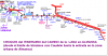
Note! When you walk in this region, you must be aware of the fact that there are three Caminos going here and there, crossing each other, going together sometimes and then splitting up again. Sometimes the places where they split up are well marked, but not always. In Villena Sureste and Lana split up. This is very well marked in Villena. We followed the Lana-route.
Levante and Sureste:
From Albacete to Minaya Levante and Sureste stay together. We were not aware of this. You should be!! They split up at the outskirt of the town! You come to Hostal Restaurante Antolin. On the left side there is a big yellow arrow on blue bottom. After a rest, we followed that arrow, but that was wrong. We hesitated, because on the map the camino passed the main road N-301 to the right, but we looked around there and saw no signs. So we thought that the route had been changed and followed the yellow arrow to the left… and went far away from where we should have been… following Camino Sureste… We stopped in a village and asked, but the people there did not know anything about different caminos. We headed for Casas de los Pinos far out of any map, and were lucky. We found it and had walked 38 km when we at last came to San Clemente.
We think that on many places Levante is not well enough signed. The parts where we went on both Sureste and Levante the route was very well signed. May be Sureste har active amigos keeping up the markings? May be The people who ones marked Levante is not active enough keeping up the marks? 6 km after San Clemente, the route turns left up to an abandoned house (well described here on the forum). We had the description, went up and down for several hundred meters looking for yellow arrows, but could not find any. So we followed some old arrows straight ahead (as the German guide said) and came to a main road. There a yellow arrow pointed straight ahead across the main road, but we could see from the guide that that was wrong. The guide told us to turn left and after some hundred meters, we turned right and were on the marked route again. Our conclusion are that Levante on some stretches has a problem with old marks fading away, while Sureste is well marked. That is not a good development for the beautiful San Clemente! Do not miss it!
Levante meet Sureste again I El Toboso, but we stopped in Las Pedrõners.
In 2013 we walked 5 days on the Levante-route from Valencia to La Font de la Figuera in April. The weather was bad – rain and low temperature - and we had to go home for family reasons.
We returned in October, started out from Alicante on the Sureste-/Lana-route, and had 12 wonderful walking days to Las Pedroñeras. So then I know something about all three routes.
The Levante from Valencia to La Font de la Figuera:
On the first days on Levante from Valencia there is a bit too much asphalt, but nice walk. We lost our way in one of the industrial areas in the small pueblos we went through. During our 12 years of waking in Spain, we have very seldom lost our way, so the route is marked, but not very well marked. (More about that later.) Stopped the first day in Almussafes at Hotel Isabel – nice. The next day one of the worst rain showers I have ever had, made us stop in Carcaixent. Less industry and more agriculture (oranges) on the third day, nice landscapes. Interesting talks with people working among the trees. Stopped in Xativa. This is a town well worth visiting.
The two next days, from Xativa to Moixent and from Moixent to La Font de la Figuera we said to each other several times, that the landscape seemed to be so nice that it could have been some of our best walking days in Spain, but actually we did not see much of it. In Moixent we stayed in a Casa Rural That we think was Casa Rural Corral de Pablanch. Very nice people.
Levante from Albacete:
The guide from the amigos in Valencia is good, but not new. From time to time, the route is changed. Between Higueruela and Hoya Gonzalo is one of these places. When you come to Oncebreros, the map in the guide tell you to turn left on the main road, but the signs tell you to cross the main road and walk up to a small farm. Follow the signs. Turn left just before you reach the farm, and you will have a nice walk among the fields.
When you leave Chinchilla too, you should follow the signs and not the map in the guide. When you have crossed the A31 and have walked down towards the railway, the map tell you to take the first road to the right, but you should wait and take the next road to the right – before you come to the railway. Then you cross over and follow the road. All the way to Albacete you stay left of A31.
We also had the guide from Conrad Stein Verlag (Camino de Levante von Valencia nach Zamora) and found it more updated than the guide from the amigos in Valencia. The German guide and the maps in the Spanish guide was an excellent combination.
All three routes:
Note! When you walk in this region, you must be aware of the fact that there are three Caminos going here and there, crossing each other, going together sometimes and then splitting up again. Sometimes the places where they split up are well marked, but not always. In Villena Sureste and Lana split up. This is very well marked in Villena. We followed the Lana-route.
Levante and Sureste:
From Albacete to Minaya Levante and Sureste stay together. We were not aware of this. You should be!! They split up at the outskirt of the town! You come to Hostal Restaurante Antolin. On the left side there is a big yellow arrow on blue bottom. After a rest, we followed that arrow, but that was wrong. We hesitated, because on the map the camino passed the main road N-301 to the right, but we looked around there and saw no signs. So we thought that the route had been changed and followed the yellow arrow to the left… and went far away from where we should have been… following Camino Sureste… We stopped in a village and asked, but the people there did not know anything about different caminos. We headed for Casas de los Pinos far out of any map, and were lucky. We found it and had walked 38 km when we at last came to San Clemente.
We think that on many places Levante is not well enough signed. The parts where we went on both Sureste and Levante the route was very well signed. May be Sureste har active amigos keeping up the markings? May be The people who ones marked Levante is not active enough keeping up the marks? 6 km after San Clemente, the route turns left up to an abandoned house (well described here on the forum). We had the description, went up and down for several hundred meters looking for yellow arrows, but could not find any. So we followed some old arrows straight ahead (as the German guide said) and came to a main road. There a yellow arrow pointed straight ahead across the main road, but we could see from the guide that that was wrong. The guide told us to turn left and after some hundred meters, we turned right and were on the marked route again. Our conclusion are that Levante on some stretches has a problem with old marks fading away, while Sureste is well marked. That is not a good development for the beautiful San Clemente! Do not miss it!
Levante meet Sureste again I El Toboso, but we stopped in Las Pedrõners.
Attachments
Last edited:


