• Get your Camino Frances Guidebook here.
  • For 2024 Pilgrims: €50,- donation = 1 year with no ads on the forum + 90% off any 2024 Guide. More here.
    (Discount code sent to you by Private Message after your donation)
  • ⚠️ Emergency contact in Spain - Dial 112 and AlertCops app. More on this here.

Search 69,459 Camino Questions

Descent into Molinaseca

PAK

New Member
Time of past OR future Camino
Frances
I walked the CF in 2022 and found the descent into Molinaseca after Alto Altar extremely challenging - in fact, it nearly broke me. On 5 May I return for my 2nd CF and would like to know how others tackled this descent. Are there alternative ways down?
 
A selection of Camino Jewellery
I walked that section in January when there was some ice and snow around. Too risky on the rough rocks for my liking. I walked down the road for the last 5km or so from Riego de Ambros. Quite spectacular in its own right. Do try to wear something high-vis (rucksack cover or vest) if you do that to make yourself more obvious to traffic.
 
I walked that section in January when there was some ice and snow around. Too risky on the rough rocks for my liking. I walked down the road for the last 5km or so from Riego de Ambros. Quite spectacular in its own right. Do try to wear something high-vis (rucksack cover or vest) if you do that to make yourself more obvious to traffic.
Sound advice, that last section is what killed me.
 
The focus is on reducing the risk of failure through being well prepared. 2nd ed.
This is my single favorite day on the Frances, but I am part goat, and have good knees. Anyone with bad knees should seriously consider breaking it up by stopping in Acebo, and taking a taxi to molinaseca. It is the longest steep descent on the Camino, and anyone who has trouble on descents needs to treat it with respect. The trail itself is also mostly dragon's teeth (lots of jagged rock), and that, along with the steep descent is what makes it so tricky. Walking the road takes the tough trail out of the equation, but it's still very steep.
 
Ideal pocket guides for during & after your Camino. Each weighs only 1.4 oz (40g)!
As I limped down I reminded myself that I was staying in molinaseca in a big private room right on the river and that the river was cold I could put my feet in it after.
But it was killing me. Even with the funny podcast in my ear. Will remember the road next time. 😂
 
I walked the CF in 2022 and found the descent into Molinaseca after Alto Altar extremely challenging - in fact, it nearly broke me. On 5 May I return for my 2nd CF and would like to know how others tackled this descent. Are there alternative ways down?

I have twice walked Rabanal past Molinaseca onto Ponferrada. I found it tougher mentally and physically than O’Cebreiro and Pyrenees.

If I ever walk this stretch again I will take the road.
 
Down bag (90/10 duvet) of 700 fills with 180 g (6.34 ounces) of filling. Mummy-shaped structure, ideal when you are looking for lightness with great heating performance.

€149,-
After the first ghastly time I always walked the road down to Molinaseca.
On weekends in good weather do watch out for bikers in pelotons often training for a race. Good luck and Buen camino.
 
Last edited:
Join our full-service guided tour of the Basque Country and let us pamper you!
I walked the CF in 2022 and found the descent into Molinaseca after Alto Altar extremely challenging - in fact, it nearly broke me. On 5 May I return for my 2nd CF and would like to know how others tackled this descent. Are there alternative ways down?
You asked about how this descent has been tackled...
In 2006, on my first camino, after a very nourishing breakfast in El Acebo, we almost skipped down, overtaken by two Spanish miners on a bit of a holiday, smoking and talking fit to burst... We had almost copied their breakfast choice in El Acebo, but had skipped their last course - a rather strong spirit...(that might help to smooth the path?)
There is a memorial in El Acebo to a young - Japanese? - cyclist who came to an early end.
I did not find the descent difficult, and I was totally new to physical challenges at that age - I was 58, which was rather late to be beginning the active life, wouldn't you say? 😁
(totally new = bone lazy)

Edit :my current avatar photo was taken looking left, around where Tomas has his place. It reminded me so much of the vistas of my upbringing.
 
Last edited:
The one from Galicia (the round) and the one from Castilla & Leon. Individually numbered and made by the same people that make the ones you see on your walk.
Well, that descent is something special. For me it was extra special, thanks to some kind of pollen flying around that made my eyes water and itch. Not that i'm big on allergies, but seems like early June there is something in that area my system doesn't like. So with watering eyes added to two long days of walking (the day before i woke in Villar de Mazarife...) this section was quite hard on me. In a different scenario i think i would have quite enjoyed that path since it's more "technical" than most of the camino (well, and the views are stunning).
 
Walking poles are your best friends when descending there (and anywhere else)…

View attachment 145885
View attachment 145884
That looks like a tough descent and I have a couple of candidates for where it might be!! While it looks like these two have extended their poles at least a little, it pays to have one's poles as long as needed to maintain a balanced, upright stance, and not have to bend forward to get the poles in front of you.
 
The one from Galicia (the round) and the one from Castilla & Leon. Individually numbered and made by the same people that make the ones you see on your walk.
That looks like a tough descent and I have a couple of candidates for where it might be!! While it looks like these two have extended their poles at least a little, it pays to have one's poles as long as needed to maintain a balanced, upright stance, and not have to bend forward to get the poles in front of you.
You are right as always:)
Exact location below. It is so nice to dive into memories …

IMG_9124.jpeg
 
Last edited:
Technical backpack for day trips with backpack cover and internal compartment for the hydration bladder. Ideal daypack for excursions where we need a medium capacity backpack. The back with Air Flow System creates large air channels that will keep our back as cool as possible.

€83,-
I walked that section in January when there was some ice and snow around. Too risky on the rough rocks for my liking. I walked down the road for the last 5km or so from Riego de Ambros. Quite spectacular in its own right. Do try to wear something high-vis (rucksack cover or vest) if you do that to make yourself more obvious to traffic.
I too walk later in the year and always have my head turning and ears and eyes open and walk on the road.
 
On that part I developed a nasty little blister on my pinky toe. I walked on to the clinic "de la Reina" in Ponferrada, where I attended to pilgrims hours. They seen the blister and gave their best.

After the climb up to O'Cebreiro in Sandals I decided to give it a second try in Triacastela and that worked out very well. The young physician cut away the surrounding callus and opened the blister. Instant relief!
Walked the next days 20+km without any problems!

The Pyrennees were a nice little walk compared to the descent down to Molinaseca (very hot and very dry).
 
I walked the CF in 2022 and found the descent into Molinaseca after Alto Altar extremely challenging - in fact, it nearly broke me. On 5 May I return for my 2nd CF and would like to know how others tackled this descent. Are there alternative ways down?
I walked the road. Not exciting, but safe!
 
The 2024 Camino guides will be coming out little by little. Here is a collection of the ones that are out so far.
I walked the CF in 2022 and found the descent into Molinaseca after Alto Altar extremely challenging - in fact, it nearly broke me. On 5 May I return for my 2nd CF and would like to know how others tackled this descent. Are there alternative ways down?
All of the comments here brought back a lot of memories of this descent. Not sure f you can enlarge this pic or not, but here is my description and pictures from that day.930C7EBF-5597-4175-9541-D9B50E6B799C.jpeg
 
We walked the road from El Acebo. A bit dull but all I could have handled that day.
Some photos:
DSC02082.jpgDSC02088.jpgDSC02090.jpg
 
Rick M writes almost exactly my own thoughts. I too am part mountain goat, having spent my early years living in a mountainous area.
I love it too, but after this - my 8th time walking this stretch in 10 years - my feet were punished “Big Time” for the first time. It was a hot day and I tackled it too enthusiastically.
I think this is the most technically challenging of all descents on CF in non-winter conditions, but tackled with care and “respect” it is fine and very rewarding. Very beautiful in fact.
If weather conditions are poor, I’d suggest like Bradypus, avoid it and walk the road or take a taxi.
 
The focus is on reducing the risk of failure through being well prepared. 2nd ed.
Both times I walked from Rabanal, I was completely beat by the time I got to El Acebo and decided to stay there for the night. And both times, the next day I woke up fresh and renewed and thoroughly enjoyed the walk down to Molinaseca and on to Ponferrada. It is a challenging descent because you have to be super careful with your footing at all times, but the scenery is just beautiful. So my recommendation is to walk it first thing in the morning and not at the end of an already hard day of walking.
Good luck and buen camino!
 
Transport luggage-passengers.
From airports to SJPP
Luggage from SJPP to Roncevalles
I walked the CF in 2022 and found the descent into Molinaseca after Alto Altar extremely challenging - in fact, it nearly broke me. On 5 May I return for my 2nd CF and would like to know how others tackled this descent. Are there alternative ways down?
Yes. The country road with very little traffic runs more or less parallel to the Camino path all the way down to Molinaseca. It is about 1 km longer, however you get to enjoy the wonderful view all the way down instead of looking down at the path and being scared of slipping or falling.

On my first Camino Frances I took the path, and swore never to do that again. I have always taken the road all the way down since then. It is a really nice and relaxed walk down.
 
The focus is on reducing the risk of failure through being well prepared. 2nd ed.
I loved that descent into Molinaseca. However, I had portered my backpack from Rabanal so I was not quite so top-heavy. I agree it is not for everyone.
 
Let's not frighten off the newbies! Many thousands of walkers have completed this route without incident. I walked it last year, my 70th, and with a dodgy knee, and found that, with a trekking pole, and looking carefully at where I was going, it really wasn't that difficult. This, however, was on a warm summer's day - I wouldn't fancy it in rain or cold. It is, on any view, a tiring descent. But infinitely more fun than the road!
 
Just did the walk today from Rabanal to Riegos
De Ambros. What a gorgeous day! Hard and rewarding. It’s my third time walking this descent and here are my thoughts.

I too, might be a bit of a mountain goat. My knees are healthy and I currently don’t have feet issues (inflamed Achilles but ibuprofen takes care of that). So this descent isn’t too stressful for me.

As another commenter stated, I enjoy the technical aspects of the descent. Walking up hills, I’m a big baby. However, descending forces me to think about how/where I need to strategically place my feet and walking sticks. I compare it to rock climbing. It’s way to focus my energy and I enjoy this type of concentration.

If you have knee/foot/ankle issues, of course plan accordingly. The road is an option, but personally for me walking on asphalt is absolute murder on my feet and knees.

For sure break up the day by stopping before Molineseca. You’ll be fresh the next day and your legs won’t be fatigued (less chance of injury).

Again, absolutely gorgeous day and the municipal in Riegos de Ambros has 5 peeps tonight, so a quieter option than touristy El Acebo.

F47826AE-7C26-46CC-AE82-68305DDDA377.jpeg
 
Last edited by a moderator:
The focus is on reducing the risk of failure through being well prepared. 2nd ed.
Let's not frighten off the newbies! Many thousands of walkers have completed this route without incident. I walked it last year, my 70th, and with a dodgy knee, and found that, with a trekking pole, and looking carefully at where I was going, it really wasn't that difficult. This, however, was on a warm summer's day - I wouldn't fancy it in rain or cold. It is, on any view, a tiring descent. But infinitely more fun than the road!
Here here! Everyone I walked with today survived to tell the tale.
 
I walked the CF in 2022 and found the descent into Molinaseca after Alto Altar extremely challenging - in fact, it nearly broke me. On 5 May I return for my 2nd CF and would like to know how others tackled this descent. Are there alternative ways down?
I just made the descent. I started on the trail and after walking about 30 minutes down the very steep rocky and dangerous pathway, I decided to walk along the road. It is a 2 Lane road and between 8:00 and 11:00 in the morning there was very little traffic and what traffic there was did not seem dangerous in anyway. There were no dangerous blind spots. It seemed much safer on the highway than on the path.
 
The focus is on reducing the risk of failure through being well prepared. 2nd ed.
I walked the descent yesterday and today. Yesterday from Rabanal to Acebo. Today from Acebo to Ponferrada. I did not have poles. It was not that difficult what I had expected. My strategy was to walk the descents very very slowly. Concentrating on each step. And stopping many times to enjoy the beautiful sceneries. It probably had been more difficult if the ground had been wet but now the weather was dry and lovely.
 
€2,-/day will present your project to thousands of visitors each day. All interested in the Camino de Santiago.
I think what @truenorthpilgrim suggests is a good idea. Plan to do this stretch early in the day when you’re fresh. My companions and I did it first thing in the morning after overnighting in Acebo, and found it a fun and challenging descent. Also glad to hear that @Glenshiro managed it at age 70 and with a dodgy knee. I did it ten years ago at age 60 and was wondering if i should still be thinking of atrempting It again.

Come to think of it, I found the trek down to Acebo the previous day very difficult; I guess I was tired, it being the end of the day. I was grateful for my stash of chocolate to help me down that descent.
 
St James' Way - Self-guided 4-7 day Walking Packages, Reading to Southampton, 110 kms
I have posted about this alternative recently and wonder if anyone has taken the suggestion yet. There is a beautiful wooded trail from Riego de Ambrós to Molinaseca. It is well known in the area, called the Puentes de Malpaso, and it passes by two very old bridges. It is not rocky and the grade is not outrageous. Details here.
The day I descended into Molinaseca (Nov 2021) was my absolutely worst day on the entire Camino by far. I slipped, fell, and hurt my leg. Fortunately, after a break, I was able to continue, but I was in a very foul mood all day. I was too upset to stop for a break in Molinaseca and just kept walking, hoping to walk off my anger regarding the fall which almost ended my Camino. I certainly intend to take the alternate route next time. Thank you for sharing it. (I had already read your original post and entered the information into my spreadsheet for my next Camino.) However, I don't recall seeing any markers in the small town that indicated the turn off. It seems to me the local government would be keen to offer an alternative route other than a narrow, twisty road. A sign would be most helpful. I look forward to reading what might be posted by anyone walking the route.
 
Plan to do this stretch early in the day when you’re fresh. My companions and I did it first thing in the morning after overnighting in Acebo, and found it a fun and challenging descent.
I thought it challenging, but very interesting with the angled bluestone path underfoot part of the way. I too, had stayed in Acebo, and I'm sure being fresh with new energy helped. It is one of my most vivid and beautiful memories on the Frances...Nearing Acebo, and on the way to Molinaseca.


Screenshot_20230502-175133~2.pngScreenshot_20230502-174926~2.png
 
Last edited by a moderator:
I will admit that the descent into Molinaseca from Riego de Ambros was one of my least favourite sections of the Camino. I suppose it didn't help that we were walking it in the pre-dawn and me with my knees shot.
 
3rd Edition. More content, training & pack guides avoid common mistakes, bed bugs etc
The first time I walked it was in the opposite direction after a rainy night. 'Thank God I am doing this going up' I thought to myself. I then did it going down several years later. 'Never again' I told myself. So in 2015 and this year, I walked Al Acebo to Molinaseca on the road. It is 2 kms longer but worth it to save myself from a bad fall - also I now have an arthritic knee. There was very little traffic on the road (I walked it in April this year)
 
I will admit that the descent into Molinaseca from Riego de Ambros was one of my least favourite sections of the Camino. I suppose it didn't help that we were walking it in the pre-dawn and me with my knees shot.
The first time I walked it was in the opposite direction after a rainy night. 'Thank God I am doing this going up' I thought to myself. I then did it going down several years later. 'Never again' I told myself. So in 2015 and this year, I walked Al Acebo to Molinaseca on the road. It is 2 kms longer but worth it to save myself from a bad fall - also I now have an arthritic knee. There was very little traffic on the road (I walked it in April this year)
oh, people, I want to shout from the rafters. Walk the Puentes de Malpaso trail from Riego to Molinaseca. It is shady, green, beautiful, and not steep or rocky.
 
Just take the road. No section of the Camino is worth being injured on when there's an alternate safer path running parallel.
 
Join our full-service guided tour and let us convert you into a Pampered Pilgrim!
oh, people, I want to shout from the rafters. Walk the Puentes de Malpaso trail from Riego to Molinaseca. It is shady, green, beautiful, and not steep or rocky.
This is excellent information. Unfortunately, you posted about this alternative in January of this year and I walked the trail in the summer of 2016. I will try and remember for next time I walk past (I think my next CF is likely to start a little later at Villafranca del Bierzo).
 
Actually, I started posting about it in 2015, if you do a search. 😁
I did a search. But the more recent posts were at the top and I didn't go through them all, just far enough to follow the link in your post 41 in this thread. Colour me lazy. I don't think I was reading these forums in 2015, before my second Camino. :D
 
3rd Edition. More content, training & pack guides avoid common mistakes, bed bugs etc
I walked the descent yesterday and today. Yesterday from Rabanal to Acebo. Today from Acebo to Ponferrada. I did not have poles. It was not that difficult what I had expected. My strategy was to walk the descents very very slowly. Concentrating on each step. And stopping many times to enjoy the beautiful sceneries. It probably had been more difficult if the ground had been wet but now the weather was dry and lovely.
Hi Kulkija, I’m the guy you helped in Ponferrada to find my hotel 😀 How are you doing?
 
I actually fell on the way up! The path was partly overgrown so I didn't see a root protruding. Went down like a sack of spuds and cut my elbow so was not feeling my best as I started the descent which got harder and harder and seemed endless. As many have posted above my thoughts were "Never again!" . But the first beer at the cafe in Molinaseca made up for it. (No, it didn't! By the time I got number three I almost forgave it.)
 
The one from Galicia (the round) and the one from Castilla & Leon. Individually numbered and made by the same people that make the ones you see on your walk.
My day to Molinaseca ended in cursing and swearing: At the last place when the trail crosses the road, there was a massive flock of sheep, and they covered the waymarker. So I took the winding road down and my knees were none too pleased, they were cursing too!
So I do not know what I was missing then when taking the wrong turn, but now everybody is telling!


sb send me this :

full
 
Last edited:
There are a couple curves where you would be extra cautious regarding oncoming autos

Trying not to teach my grandmother how to suck eggs, but rules/guidance for road walking:
  • walk facing the oncoming traffic - on the left (in Spain, as in much of the world), except:
  • walk on the OUTSIDE of a curve/bend
  • if the curve/bend is to your right you stay on your left and will see any oncoming traffic naturally "drifting" away from you towards the centre line (marked or unmarked)
  • if the curve/bend is to your left, you walk on the right and will notice traffic coming from behind you is "drifting" away from you towards the centre line
The "trick" with curves/bends is judging when to cross the road and back again. Like most things to do with long distance walking, it just takes practice.

Kia kaha (take care, be strong)
 
St James' Way - Self-guided 4-7 day Walking Packages, Reading to Southampton, 110 kms
A further detail is here at Hiking.WayMarkedTrails.org.
Have you walked this route, @AlwynWellington? There are many places to find GPS tracks, including wikiloc, but what I’d love to see is a report from someone other than me who has walked this alternative!

It kills me that people are going over to walk on the road in order to avoid the rocky descent, when there is an absolutely gorgeous trail that is well-marked and well-maintained!
 
Yes, it was an epically (beautiful) downhill for my knees. Oofdah Descent. Clearly people have gotten hurt on this section.....However, with caution and slow speed
AND walking poles.... you (all) can do it and will NOT regret this epic part of the Camino... Molinaseca is THE REWARD at the end of this difficult demanding descent with detritus. I just wish I knew the beauty of Molinaseca beforehand as I would have DEFINATELY taken a day off there ! It's a real gem and oasis. Next time! (however, God willing (and spouse) I head out in September Camino numero dos. Buen Camino y'all
 

Attachments

  • Molinaseca descent.jpg
    Molinaseca descent.jpg
    1 MB · Views: 27
  • antes Molinaseca.jpeg
    antes Molinaseca.jpeg
    4.9 MB · Views: 24
Last edited:
Yes, it was an epically (beautiful) downhill for my knees. Oofdah Descent. Clearly people have gotten hurt on this section.....However, with caution and slow speed
AND walking poles.... you (all) can do it and will NOT regret this epic part of the Camino... Molinaseca is THE REWARD at the end of this difficult demanding descent with detritus. I just wish I knew the beauty of Molinaseca beforehand as I would have DEFINATELY taken a day off there ! It's a real gem and oasis. Next time! (however, God willing (and spouse) I head out in September Camino numero dos. Buen Camino y'all
Please don't say 'you (all) can do it.' As I said earlier in my post I have an arthritic knee and that descent would have been dangerous for me. Yes, there may be an alternative lovely, non-dangerous path but I did not know of it - and judging by this thread, nor do many others. Why has it not been marked as an alternative Camino?
 
Technical backpack for day trips with backpack cover and internal compartment for the hydration bladder. Ideal daypack for excursions where we need a medium capacity backpack. The back with Air Flow System creates large air channels that will keep our back as cool as possible.

€83,-
I remember that stretch. We did OK by taking it slow and stopping at one of the towns up the hill from Molinaseca. I recall it was Ascebo. I agree it was a particularly steep and rocky patch. We met a woman walking alone who was really struggling. We slowed down and walked with her because we thought she might not make it. At Ascebo we called her a cab to take her down to her pre-arranged lodgings in Molinaseca. I also recall we tool the road near the bottom because the trail was steep and miserable. Take care of yourself and look out for others on that stretch.
 
Have you walked this route
Sadly no.

My training jaunts up and over 400 m hills that surround me on steep dirt littered with rubble have prepared me for most situations.

In May 2016 I had pulled hip muscles on the descent from Alto del Perdon. After much effort and anguish, I eventually pulled away to seek treatment in London (and walk Thames Path and then from Southwark Cathedral to Canterbury Cathedral).

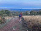
Fully recovered I returned to Estella in October 2017 (to continue from my effective stopping point in 2016). Even then I was not looking forward to the descent into Molinaseca.

On arrival at Leon from Reliegos I suffered stomach upset. After two rest days I carried on to Hospital and the next day to Astorga, where I almost fainted. Next day bused to Ponferrada for another rest day and a slow next day to Cacabelos. From there it was all go for five days to be in Compostela just before All Saints Day.

As you ask the question, I have just now done my route finding homework.

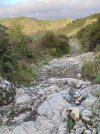
Using street level images from May 2019 in Riego de Ambros I could see the occasional, and very discrete, yellow arrow. Finally a narrow unsigned street. I understand this is "Calle Las Cancillas". A sign on the corner says "Las Puentes de Malpaso". As it is on the uphill side of Calle Real, it is not visible to pilgrims approaching from Rabanal. And nothing suggests a way to Molinaseca starts here.

And, using street level images from August 2013, I went to Calle de Soto. There I could see a path coming from the south east (and up from the river) and entering Molinaseca: no signage at this end, although the images are 10 years old.

I have also looked up the mapping history and find the yellow route on the link I gave you was created in July 2015, so quite old. And that it is named "Ruta de las Puentes de Malpaso".

On balance, if this alternative was on my list of possibles, I suspect I would miss the start point in Riego.

If "the authorities" could add signage on the downhill side of Calle las Cancillas and add text to the effect of "alternative to Molinaseca" (but no yellow arrows or other "official" stuff), then your entreaties might be heard.

Kia kaha (take care, be strong)
Ruta ... Malpaso - 1 of 3 - Riego de Ambros - Calle Real 60 (on left) - image from May 2019.jpgRuta ... Malpaso - 1 of 3 - Riego de Ambros - Calle Real 60 (on left) - image from May 2019.jpgRuta ... Malpaso - 2 of 3 - Molinaseca - Calle de Soto - image from August 2013.jpgRuta ... Malpaso - 2 of 3 - Molinaseca - Calle de Soto - image from August 2013.jpgRuta ... Malpaso - 3 of 3 - Molinaseca - Calle de Soto - image from August 2013.jpgRuta ... Malpaso - 3 of 3 - Molinaseca - Calle de Soto - image from August 2013.jpg
 
The 9th edition the Lightfoot Guide will let you complete the journey your way.
oh, people, I want to shout from the rafters. Walk the Puentes de Malpaso trail from Riego to Molinaseca. It is shady, green, beautiful, and not steep or rocky.

The Mapy.cz app has this and many other hiking trails already built in - no need to download additional tracks.
This is what it looks like. Note the dark blue line is the Camino, and the Puente de Malpaso trail is gold.

Here's where it starts at Riego de Ambros


Puente de Malpaso trail 1.jpg


This shows the entire trail


Puente de Malpaso trail 2.jpg

And here's where it comes into Molinaseca


Puente de Malpaso trail 3.jpg
 
The Mapy.cz app has this and many other hiking trails already built in - no need to download additional tracks.
This is what it looks like. Note the dark blue line is the Camino, and the Puente de Malpaso trail is gold.

Here's where it starts at Riego de Ambros
No! Don't start there! Go down a block further first to take a picture of the iconic sign that Chris shows as the last picture in her post #44 above.

Edit: And when you do get to Molinoseca head on the Camino backwards a bit, at least over the river, and then follow it forward into town so you can see more iconic views of the Camino.
 
Last edited:
Get a spanish phone number with Airalo. eSim, so no physical SIM card. Easy to use app to add more funds if needed.
The Mapy.cz app has this and many other hiking trails already built in - no need to download additional tracks.
This is what it looks like. Note the dark blue line is the Camino, and the Puente de Malpaso trail is gold.

Here's where it starts at Riego de Ambros
@trecile, thank you

I can only say that Mapy.cz (and my variant Hiking.WayMarkedTrails.org - see the link in post #57 above) are both beautiful when seen looking down from the proverbial helicopter. Both examples, by the way, draw from Open Street Maps (OSM): by looking at the underlying history, I can see this alternative route to Molinaseca was placed in the OSM data base in 2015 - so not new.

While I love Open Street Maps and have add many routes and other stuff to the data base, it is a different matter to have the Android apps (and for other platforms) give me step by step, turn by turn advice. There can be a few steps to be taken in the app and the battery drain can be quite high.

The issue that @Bradypus (see post 63 above) and others (and I suspect me, had I actually walked that way) have is absolutely normal: where to turn on you way through Riego.

The issue is quite simply explained.
  • The street to turn into per you example #1 is called Calle Las Chinchillas - this street is not signposted
  • There is a sign saying Puentes las Mapaso (see my first image post #62) on this street - this sign does not face the pilgrim coming down the hill from Acebo etc.
  • Nor does this sign indicate any destinations
  • The other streets in the immediate vicinity are potentially a rabbit warren - while yellow arrows (VF) may be clear to walkers, I could not see any in the immediate area in the limited number of street level images. And I note the official route is bearing to the right at about this point - this factor may cause way finding attention to stray and/or be conflicted.
In my view getting this route better known is still work in progress.

The suggestion so far is for two signs to be installed on the down hill site of Calle Las Chinchillas.
One would just repeat the existing sign on the uphill side (Las Puentes las Malpoaso)
The second would say, in Spanish of course, "alternative to Molinaseca". Or words to that effect.

@trecile, are you game?

kia kaha (take care, be strong)
 

Most read last week in this forum

The Burguete bomberos had another busy day yesterday. Picking up two pilgrims with symptoms of hypothermia and exhaustion near the Lepoeder pass and another near the Croix de Thibault who was...
Between Villafranca Montes de Oca and San Juan de Ortega there was a great resting place with benches, totem poles andvarious wooden art. A place of good vibes. It is now completely demolished...
Left Saint Jean this morning at 7am. Got to Roncesvalles just before 1:30. Weather was clear and beautiful! I didn't pre book, and was able to get a bed. I did hear they were all full by 4pm...
Hi there - we are two 'older' women from Australia who will be walking the Camino in September and October 2025 - we are tempted by the companies that pre book accomodation and bag transfers but...
We have been travelling from Australia via Dubai and have been caught in the kaos in Dubai airport for over 3 days. Sleeping on the floor of the airport and finally Emerites put us up in...
Just an FYI that all available beds are taken in SJPDP tonight - fully, truly COMPLETO! There’s an indication of how busy this year may be since it’s just a Wednesday in late April, not usually...

❓How to ask a question

How to post a new question on the Camino Forum.

Similar threads

Forum Rules

Forum Rules

Camino Updates on YouTube

Camino Conversations

Most downloaded Resources

This site is run by Ivar at

in Santiago de Compostela.
This site participates in the Amazon Affiliate program, designed to provide a means for Ivar to earn fees by linking to Amazon
Official Camino Passport (Credential) | 2024 Camino Guides
Back
Top