• For 2024 Pilgrims: €50,- donation = 1 year with no ads on the forum + 90% off any 2024 Guide. More here.
    (Discount code sent to you by Private Message after your donation)
  • ⚠️ Emergency contact in Spain - Dial 112 and AlertCops app. More on this here.

Search 69,459 Camino Questions

elevation map

pistol

New Member
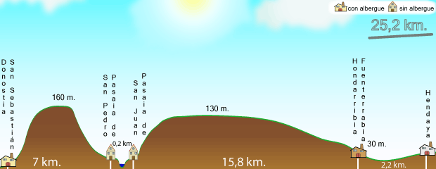
i am looking for a one or two page sheet that shows the different places along the path together with the elevation changes. I had something like this when i did the cf and it was extremely useful.

if this isn't available could someone give me their assessment on the elevation changes from irun to bilboa and/or aviles to ribadeo. if you have done both segments can you give me a relative difference eg. irun to bilboa has twice the elevation changes as aviles to ribadeo.
 
Join our full-service guided tour of the Basque Country and let us pamper you!
The 9th edition the Lightfoot Guide will let you complete the journey your way.
That Gronze site is excellent. How did you go with finding food? I prefer not to carry a whole day's worth of food and get dinner when I arrive somewhere - is this always feasible? We were told it would never be a problem on the CF but we had one day where we had to walk 17km on a madeline and an orange (that's a big ask for kids!)
 
Ideal sleeping bag liner whether we want to add a thermal plus to our bag, or if we want to use it alone to sleep in shelters or hostels. Thanks to its mummy shape, it adapts perfectly to our body.

€46,-
Eroski's elevation maps are great from 1 to 13 but after that they are of another kind and lack the distance.
 
I'm having no luck whatsoever finding what I'm looking for. Can someone point me to information that has elevation change information for these stages of the Camino Mozarabe? This is the route I walked. I can't find anyplace on the Internet that gives this information.
Hinojosa del Duque Castuera
CastueraCampanario
CampanarioLa Haba
La HabaMedellín
MedellinTorrefresneda
TorrefresnedaMérida

I'm also looking for these stages from Santiago to Muxia
SantiagoNegreira
NegreiraSanta Marina
Santa MarinaDumbria
DumbriaMuxia

I've followed the links in other responses to this thread and cannot find the information I'm looking for. Thank you.
 
I'm having no luck whatsoever finding what I'm looking for. Can someone point me to information that has elevation change information for these stages of the Camino Mozarabe?
Try Wikiloc.com. Besides the elevation difference you can see a track with distance information and a profile of the route. And you can download the track to use with GPS apps.

You can search for free. A free basic membership gives you a few privileges and a paid membership gives you even more privileges including a much better way to find a track between two places.
 
Last edited:
Down bag (90/10 duvet) of 700 fills with 180 g (6.34 ounces) of filling. Mummy-shaped structure, ideal when you are looking for lightness with great heating performance.

€149,-
Last edited:
This is the best thing I have found: long distance paths.eu

If you click on the north of Spain piece (Way of St. James), you can select chunks, eg—San Sebastián to Bilbao or Bilbao to Santander. It will give you a map, distance, all cities, villages and hamlets on that stretch with clickable links, and give elevation gains and losses for that section. It is fabulous! I plan to do Bilbao to Santiago next year, and after adding up all the ascents and descents, was shocked to find that overall climbs (14,842m) and descents (14,605m) we’re lower for CdN than for CF from SJPdP to SdC (18,666m climb/17778m descent). Can this be true!?
 

Attachments

  • 8EFC94C8-3C9B-4324-993C-5875DFF715DC.png
    8EFC94C8-3C9B-4324-993C-5875DFF715DC.png
    319 KB · Views: 11
  • D73CC5B4-A224-43D9-972E-883468B90362.png
    D73CC5B4-A224-43D9-972E-883468B90362.png
    647.7 KB · Views: 14

Most read last week in this forum

I use Alltrails a lot here in the US, in Iceland, on the Via Podiensis and a bit on the CF. Will it be useful on the Norte? For example, people here say the "warm up" from Biarritz to Irun (or...
Last May I walked the first part of the Norte in the opposite direction, from Santander to Irun. Since I only had two weeks and couldn't reach Santiago anyway, I wanted to swim against the tide...
Tomorrow I fly to Bilbao to start my 5th stint on the Camino. I did the Frances in three parts (2016, 2017 and 2022). Last year I did the Portuguese from Porto. I did the first 200 km of the...
I thought I had this all figured out, but I have ended up with 2 train tickets from San Sebastian (I don't even know if it's the airport or the town) to Irun, instead of ONE that goes all the way...
Hi! I’m a Camino newbie planning on walking Camino del Norte this May-June. I have previous hiking experience and do well on longer distances and so on, but not any super recent multi day long...
I’m on day 2 of the CDN and I’m just blown away by the views. Day 1 Irun to San Sebastián, day 2 San Sebastián to Askizu Buen Camino

❓How to ask a question

How to post a new question on the Camino Forum.

Forum Rules

Forum Rules

Camino Updates on YouTube

Camino Conversations

Most downloaded Resources

This site is run by Ivar at

in Santiago de Compostela.
This site participates in the Amazon Affiliate program, designed to provide a means for Ivar to earn fees by linking to Amazon
Official Camino Passport (Credential) | 2024 Camino Guides
Back
Top