

bjorgts
Active Member
- Time of past OR future Camino
- In Spain, France, Portugal, Germany since 2003
On our hike on the Camino del Ebro this April / May, we had two days on the Camino Castellano-Aragonés. Then it was time to end the hike. It was two great days! Sun, green fields, flowers, good roads, variety. Eventually a small photo video comes out. Now I just wanted to make a few comments on the route, which might help someone.
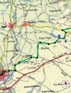
First day Gallur - Borja
I see that eobennet4 has had problems crossing the two major roads that run parallel on the first day. Here is a description: The route is well marked. Follow the arrows until you come down through the olive grove and encounter the A-68 / N-232. (From there we saw no arrows for a while.) Turn left down along the olive grove until you reach an underpass (100-200 m?). Turn right through the two underpasses that are located one after the other. Then you come out on a paved road. Turn left on this and walk a short distance (100 m?). Turn right on the first road, and go straight ahead between two large industrial buildings. Keep straight ahead and you will see in front of you an underpass under the E-804. There is a faded arrow on the wall. Go through this underpass. Turn right up parallel to the motorway (100 m?). Then turn left and you are on the camino. There is a pole with a mark on it. First picture is a screenshot of these passes (blue color). I do not remember where I found it.
A few kilometers later came a point I had trouble interpreting. We stood at an intersection and had Magallon in front of us a few kilometers away. I have a Spanish App-map on my mobile with the Santiago camino marked, and there the route continued straight ahead. A GPS track I had also went straight ahead. But on the road that turned right, there was a clear yellow arrow. We followed the arrow. It turned out to go to the small village of Bisimbre and there the arrow pointed on to Agón. When we checked the GPS track from Asociación Soriana later, we saw that that track also went straight ahead like my other tracks. (We took a road to the left at Bisimbre back to the "old" track so as not to get too far to go to Magallon. There were no arrows there, or maybe just some old faded ones.) I also found a GPS track that goes through the two small villages, so that's probably where the markings with yellow arrows are now. It was not difficult to walk the old route straight ahead, since we do not have to depend on the yellow arrows to find our way. On my second screenshot you can see that the blue track (Asociasón Soriana) and the green track (my track) go the same way - straight ahead. The blue dot shows where the yellow arrow points to the right.
Second day Borja – Tarazona
We had a GPS track and were not dependent on the yellow arrows, but agreed that we would probably have found the way by following them. This day there are some stretches where you do not see much road / path, but it was not a big problem to walk there. A small comment on the place peregrina2000 calls a "bowl". https://www.caminodesantiago.me/community/threads/eobennett-on-the-soriano-aka-castellano-aragonés.74695/#post-1028511 To get to this bowl you have to turn right from the gravel road you walk on in the right place. The arrow was not very clear there, but the place can be easily explained. You are approaching a small building in red brick on the right side of the road, and I do not think we saw other buildings in red brick on this part of the route. Just before this building (50 m?) the route turns right up between two fields. Follow the overgrown road that eventually turns right up to a house ruin. Turn left behind this ruin and you are on your way up on the right side of the bowl. In the middle of the top, the route turns to the right.
Good luck to everyone!
Attachments

Last edited:


