• For 2024 Pilgrims: €50,- donation = 1 year with no ads on the forum + 90% off any 2024 Guide. More here.
    (Discount code sent to you by Private Message after your donation)

Search 69,459 Camino Questions

Geotagging photos easily if your camera is not GPS enabled

BobM

Veteran Member
Time of past OR future Camino
V Frances; V Podensis; V Francigena; V Portugues; V Francigena del Sud; Jakobsweg. Jaffa - Jerusalem
On my VF walk in July I want to geotag photos so that they can be quickly and accurately linked to my route. My camera does not have GPS functionality, nor does my un-smart mobile phone.

One problem with using GPS and navigating apps on those devices to record accurate "tracks" is battery drain.

So I am taking a Garmin Dakota 20 GPS unit that takes AA batteries (either rechargeable or single-use alkaline batteries). Garmin claims 20 hours battery life, but I find that battery life is roughly 1.5 days (say 12 hours) when the unit is recording a track and is also in frequent use to follow a route.

It is very easy for novices like me to add position and time data from the GPS unit to the photo files so that they can be viewed in Google Earth and uploaded to other mapping apps.

First you have to set the camera time to the same time shown on the GPS unit. My camera and GPS unit don't show seconds, but even so I can manually synch the time to within a few seconds accuracy. Its just a matter of adjusting the camera time a minute ahead of the GPS unit time and hitting "Set" on the camera when the GPS time ticks over to match the camera.

Check the synch every day or so until you are confident of its accuracy. My GPS unit is set (by default) to record an accurate track when it is turned on. You don't have to worry about it during the day, but you need to save the track at the end of the day so that is easier to geotag photos of a whole walk at home.

By the way I am using "tracks" in the sense that Garmin and GPS users mean it.

You can adjust the way tracks are recorded by the GPS unit, but I just stick with the factory default settings.

Every photo automatically has the time added to it, so you don't have to worry about that.

The next operation involves using the time data automatically recorded with each photo to locate the position coordinates for the same time on your saved tracks.

That's very simply done with a free app like GPicSync available from http://code.google.com/p/gpicsync/. But you can find other apps by googling "geotagging software" for example.

Free apps bother me from a security viewpoint, but as far as I can tell from a McAfee scan and googling for GPiSynch scams, it seems to be clean - ie probably no embedded spyware or other malicious code. But even so, I installed it on a spare computer not connected to the internet and did all the following work on that computer, transferring only the final images and the KML file to my main computer.

First copy the track file (it is in GPX format) from the GPS unit to your computer desktop (or any other location you prefer).

Then download all your pics for that day to a folder on the desktop.

Fire up GPicSync and enter the photo folder location (just "browse" to locate it). Do the same for the location of the track file. Enter the time zone where the pics were taken.

Then hit syncrhonise and GPicSync will add position data to each pic (in its EXIF file) from the track file using the time data. Typically it will find a recorded track location within a few seconds of the pic time. That accuracy is good enough for linking your pics of a country walk to a map. It may not be good enough if you are in a city and need very accurate locations for pics of monuments, buildings etc.

The software adds the position data to each pic, but it saves the original unprocessed pics in a separate folder. It also creates a text log where you can see the exact data it has added. Finally it creates a KML file that can be viewed in Google Earth.

Clicking the KML file fires up Google Earth, where you can see your track for the day as well as accurately positioned thumbnails of all the photos.

If a complete GPS novice like me can do all this at a first attempt, anyone can do it! Describing it is far more complicated than actually doing it.

Rgds

Bob M
 
3rd Edition. More content, training & pack guides avoid common mistakes, bed bugs etc
wow...or you can see if a friend has an old smart phone lying around that you can use for both camera and geotracking/tagging (all from a single app). That's the route I went with. ;) Plus, it'll do lots of other stuff too.

Be sure to bring a charger and rechargable batteries for the GPS device since you'll burn through about 50 batteries on the trip otherwise, and that's both expensive and bad for the environment.

But those who intend to carry GPS devices will find this helpful, I'm sure! Geotagging photos is fun!
 
@bobm: My inner nerd offers the following suggestion...

Just Use Garmin's "Basecamp" software to geotag your photos, especially if you're already using a Garmin device. It's free, just plain works, and was written by Garmin so you don't have to concern yourself trying to find "safe" 3rd-party code.

Basecamp also has a feature that allows you to adjust for mismatches between the timestamps of your photos and your GPS tracks. So if you forget to synchronize the clocks on your camera and your GPS (or if you just don't want to bother with it) you can still match them up after-the-fact.
 
Ideal sleeping bag liner whether we want to add a thermal plus to our bag, or if we want to use it alone to sleep in shelters or hostels. Thanks to its mummy shape, it adapts perfectly to our body.

€46,-
If you are going through that complex procedure just because of fear of battery drain, there is an alternative. A smart phone running the "GPS Kit" app with any of several camera apps will work just fine; turn off the other apps running in background to conserve the battery. I was taking several dozen pictures daily and could easily have skipped an overnight re-charge.
 
Bob, personally you are doing the right thing. I walked with a Garmin and uploaded my photos onto a website called everytrail. They give you unlimited space

As for smart phones, I have one but do not find the GPS as accurate as a Garmin, and I wouldn't bother with the photo side either, the clarity is nowhere good enough for me and with the amount of shots that I take, the battery would die to quickly

One thing I would do is set the GPS up so it tracks you the most often. As for power, I was using rechargeable batteries and had no problems
 
vagabondette said:
wow...or you can see if a friend has an old smart phone lying around that you can use for both camera and geotracking/tagging (all from a single app).


I find that with a phone the battery life is poor, the photo quality worse, and they are delicate. I have the same Dakota 20 BobM uses, and it can sit in a bike handlebar mount in the pouring rain all day. Plus, it is easy to read in direct sunlight.

Thanks for the post Bob! One point people miss with GPS is what a great journal it records for you.
 
New Original Camino Gear Designed Especially with The Modern Peregrino In Mind!
newfydog said:
vagabondette said:
wow...or you can see if a friend has an old smart phone lying around that you can use for both camera and geotracking/tagging (all from a single app).


I find that with a phone the battery life is poor, the photo quality worse, and they are delicate. I have the same Dakota 20 BobM uses, and it can sit in a bike handlebar mount in the pouring rain all day. Plus, it is easy to read in direct sunlight.

Thanks for the post Bob! One point people miss with GPS is what a great journal it records for you.

Depends on the phone. Mine has a great camera which is only made better with a couple free apps. I was talking about this with a friend who is a professional photographer last night. I showed her some of my pics from my phone and she couldn't believe the quality. She'd have never guessed they were from a phone. I've blown them up to 8x11 with great quality. Could probably go higher but have never tested it since prints are low on my list of things I need.

Regarding battery life, I haven't charged my phone for a few days now and it's still going strong. I have everything turned off except the camera and my ebook reader and this includes about 8 hours of GPS tracking using an app that tracks my route and automatically inserts pics within the route. The nice thing about it is that I can push publish at the end of the day and I'll automatically upload the route to the app website and facebook so my friends/family can see where I am/what I'm doing. It then spits out the code that I can insert on my blog that will show the route and photos there as well and I can add the full gallery.

I just keep it in a ziplock bag and I can use it through that and it stays dry and I've never had a problem reading it in the sun. I've dropped it too many times to count and it keeps on ticking so that's not been a problem.

So yeah, I will stick with my one piece of multi-use equipment. :) But, if you already have a GPS, and/or don't have access to a high quality phone, and/or need to be able to blow your pics up to poster size, I can see how that would be a better solution.
 
Davroos said:
As for smart phones, I have one but do not find the GPS as accurate as a Garmin, and I wouldn't bother with the photo side either, the clarity is nowhere good enough for me and with the amount of shots that I take, the battery would die to quickly

Smart phone GPS apps reportedly don't lock onto satellites as well/quickly (eg under tree cover) as a dedicated GPS unit. I have no personal experience to say either way.

Photography is important for me, and I also find phone cameras too limited for my needs.

Another big plus for GPS units like the Dakota is screen readability in bright daylight. My Dakota is remarkably readable in bright light conditions where my Samsung NX200 camera OLED screen is virtually unreadable, even with a matte screen protector.

Rgds

Bob M
 
Get a spanish phone number with Airalo. eSim, so no physical SIM card. Easy to use app to add more funds if needed.
vagabondette,
what kind of phone are you using?
 
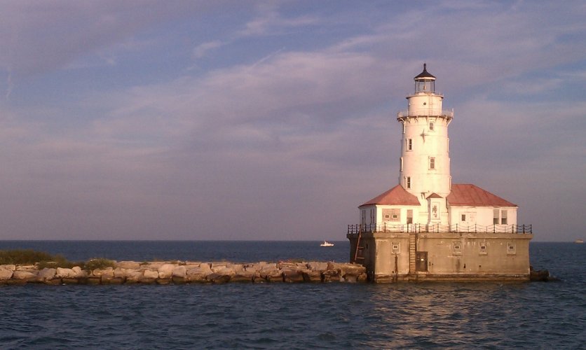
I have the first edition of the HTC incredible. It's not perfect, but it's pretty darn good. The pics aren't what you'd get from a SLR but they're pretty comparable to what most point-and-shoots can product and since the phone can also serve as my: ebook reader, guide book, gps tracker, phone, internet connection, journal and more, it's hard to justify carrying a separate camera and/or GPS device and related equipment. It's not what you want if you're a pro but if you're just taking holiday snapshots it's more than enough.

Here's an example of an unedited (aside from shrinking it by 2/3 so I could upload it) shot I took while sailing in Chicago last summer. This was just using auto settings and no additional camera apps. Since I'll only be using the pics on the web and maybe in a printed album the quality is more than enough for my needs.
 

Attachments

  • chicago lighthouse.jpg
    chicago lighthouse.jpg
    328.2 KB · Views: 1,669
ed1chandler said:
..Use Garmin's "Basecamp" software to geotag your photos, especially if you're already using a Garmin device. It's free, just plain works, and was written by Garmin so you don't have to concern yourself trying to find "safe" 3rd-party code.

Basecamp also has a feature that allows you to adjust for mismatches between the timestamps of your photos and your GPS tracks. So if you forget to synchronize the clocks on your camera and your GPS (or if you just don't want to bother with it) you can still match them up after-the-fact.

I just did a test with Basecamp. It's much easier to use (altho both apps are pretty simple) & more flexible re timestamping than the app I suggested - plus you don't have to worry about malicious code.

It's definitely a better option. Much obliged. :D

BTW, weight is a big deal for me for walking the VF, so I thought long and hard about trading in my un-smart phone for an "all-singing-all-dancing smarter-than-I-am" phone that would do everything except brew me a cuppa tea: - make calls, take pics, geotag pics. Then I could have ditched my camera and the Dakota 20.

But photo quality incl the ability to shoot RAW (I don't mean in the raw), plus battery life were the deciding factors for me. Horses for courses.

Rgds

Bob M
 
The 2024 Camino guides will be coming out little by little. Here is a collection of the ones that are out so far.
Bob

I take a Canon G10, it shoots in raw and for me is small enough. When people go on about weight, especially a gps that you wear around your neck, personally, I find it a joke. It is one of these arguments that go round and round in circles !!!

Check out http://www.everytrail.com
 
Davroos said:
I take a Canon G10, it shoots in raw and for me is small enough. When people go on about weight, especially a gps that you wear around your neck, personally, I find it a joke. It is one of these arguments that go round and round in circles !!!

Weight! . . . . I mean wait! :)

It's not just the one small object that is a big deal, it's the accumulation of many small "excesses" tucked into the pack that add up.

I have found from experience that for me to be able to happily walk long distances, day in and day out, in hot weather like my July/Aug VF walk, my pack load (excl food/water) should be less than 6kg.

So, if I can eliminate ten small excesses of, say, 100gm each I will have saved 1kg in total.

My phone, camera, GPS unit with chargers and spare batteries weigh 1.3kg. If I decided to carry only 1 of the latest smart phones, I would probably save 1kg. That's 1 litre of champagne, or an extra lobster for my lunch.

Everyone has their own load tolerance. Some folk will happily carry a 20kg pack on long walks. Lucky them!

Here endeth the sermon.

Rgds

Bob M
 
vagabondette said:
The pics aren't what you'd get from a SLR but they're pretty comparable to what most point-and-shoots can product

Actually technology marches on and there is no way a phone can touch a modern point and shoot. A phone will take a fine photo in the mid range, but the laws of physics limit what those pinholes of a lens can do for zoom, low light, etc.

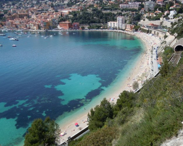
I have a little lightweight Nikon in my back pocket with an 18x optical zoom and even for "holiday snaps" one can get shots not possible with a phone. Find the two swimmers in the top photo, from our Menton to Arles trip. That camera, plus our tiny little dumb phone weigh only 56 grams more than our smartphone we leave behind. Cheaper too.

There is more than one way to get the tools you need, and it changes fast in this high tech world.
 

Attachments

  • 653 1.JPG
    653 1.JPG
    215.2 KB · Views: 1,432
  • 653 2.JPG
    653 2.JPG
    106.2 KB · Views: 1,429
€2,-/day will present your project to thousands of visitors each day. All interested in the Camino de Santiago.
newfydog said:
vagabondette said:
The pics aren't what you'd get from a SLR but they're pretty comparable to what most point-and-shoots can product

Actually technology marches on and there is no way a phone can touch a modern point and shoot. A phone will take a fine photo in the mid range, but the laws of physics limit what those pinholes of a lens can do for zoom, low light, etc.

I have a little lightweight Nikon in my back pocket with an 18x optical zoom and even for "holiday snaps" one can get shots not possible with a phone. Find the two swimmers in the top photo, from our Menton to Arles trip. That camera, plus our tiny little dumb phone weigh only 56 grams more than our smartphone we leave behind. Cheaper too.

There is more than one way to get the tools you need, and it changes fast in this high tech world.

Ok, so yes, if you're up for buying a new camera that's true. Personally, I'm not. I have a perfectly good camera that there is no reason to replace. Also, if you're into carrying equipment that only has one function then go for the camera. However, this thread was about Geotagging photos. Does your camera do that or would you need a separate GPS device which would add to your weight?

I sure that your old-school phone + camera only weigh slightly more than the smart phone. However, since I'd have to carry a camera, GPS device, Kindle, laptop, guide book, phone and more (plus all related equipment) to replace the use I would get from the smart phone, I think I'm coming out ahead...

The smart phone option isn't the best for everyone. However, I'd bet it'd work just fine and be more useful than just a camera for the majority of people.

No, I couldn't find the swimmers. Nor would I want or need to do so. :) The pics I'm taking will go on the web and be used in small print format (if they're ever printed at all). To find the swimmers on a print or on a web format of that image it would have to be quite large and I'd imagine most people won't want/need their images to be that large. But anyway, the whole point of my post is that for *MOST* people, the camera in a smart phone would work just fine. That is not the case for you, and that's fine.
 
They are right there, dots in the middle of the blob of turquoise water. My point is that even for little internet photos, a phone could not have shot the second photo. All you could get is the dots.
 
I have used my phone camera to take pics and also a camera on one of the Gramin GPS units that now include a camera. None of them are satisfying technically, but they were ok to upload to a website just as a record.

The little cameras on phones can't bring out detail in shadows without washing out highlights. There are also artefacts like "fringing" due to the quality of the tiny CCDs used. There is often barrel distortion. You can't shoot RAW when that is desirable for technically challenging shots. With tiny lenses everything is always in focus right out to infinity, but you want to be able to control depth of field in people shots. Etc, Etc.

Of course, most people probably could not give a toss about all that stuff and it may not be important anyway for casual holiday snaps, but it is important for those who want to improve their photography.

Just a simple thing like controlling depth of field can give people pics a "wow!" factor that makes a shot memorable - and gives pleasure to the person photographed.

Sometimes when travelling, strangers have asked me to take a photo of them with their camera. I usually suggest a "good" photo, but they always want tme to take them standing rigidly to attention, full-length, staring straight at the camera in front of the monument or whatever. The point is to take what they want, not my idea of what is good.

Rgds

Bob M

Rgds

Bob M
 
New Original Camino Gear Designed Especially with The Modern Peregrino In Mind!

Most read last week in this forum

One way or another, you need to see this movie! We were lucky enough this evening to attend the 'World Premiere' that was followed by a Q&A Session with: Writer / Director / Producer - Bill...
Last year on my camino I was a bit annoyed when someone back home told me to enjoy my vacation. I bristled. Why did that word annoy me so much? I was on a pilgrimage! Anyway, I'm about to embark...
I'm looking for the best app to use whilst walking on the Camino. Usually I just rely on my Apple watch but I'm leaving that at home, so need an app use that I can pause at rest stops etc...
Everyone talks about the wonderful café con leche, but what if tea is more to your liking? Can you even get tea along the Camino (Frances)? I don’t drink coffee but my morning cup of tea is...
Hey all. I haven't been on the forum for quite sometime (years probably). I walked the Camino Frances in 2016 and to say it was life changing for me is an understatement. On day 3, at the café at...
I am currently working as a Hospitalaro in a newly reopened Donativo Albergue in Vergen del Camino, just a short distance from Leon. It was closed for 5 years due to, initially the pandemic. It is...

❓How to ask a question

How to post a new question on the Camino Forum.

Similar threads

Forum Rules

Forum Rules

Camino Updates on YouTube

Camino Conversations

Most downloaded Resources

This site is run by Ivar at

in Santiago de Compostela.
This site participates in the Amazon Affiliate program, designed to provide a means for Ivar to earn fees by linking to Amazon
Official Camino Passport (Credential) | 2024 Camino Guides
Back
Top