• For 2024 Pilgrims: €50,- donation = 1 year with no ads on the forum + 90% off any 2024 Guide. More here.
    (Discount code sent to you by Private Message after your donation)
  • ⚠️ Emergency contact in Spain - Dial 112 and AlertCops app. More on this here.

Search 69,459 Camino Questions

GPS tracks for the Levante

nalod

Active Member
Time of past OR future Camino
Frances 2011, Finnesterre 2011,Le Puy to SJPDP 2011& 2012,Via de la Plata,Sambrasa 2012, Mozarabe 2013, Portugees 2013.PartNorde 2011, VDPL 2014,St-Guilhem 2014.Espalion-Roncesvalles 2014.Levante2015
Hello, just bought a new smartphone (android Samsung) for my upcoming trip and with advice on another section of this forum found an app called MAPS.ME that I can use without wifi or data roaming. If anyone who has walked the route before they might have a file of the route. This would be a great back up for me.

Thanking you Dermot (Nalod)
 
Get a spanish phone number with Airalo. eSim, so no physical SIM card. Easy to use app to add more funds if needed.
Hello, just bought a new smartphone (android Samsung) for my upcoming trip and with advice on another section of this forum found an app called MAPS.ME that I can use without wifi or data roaming. If anyone who has walked the route before they might have a file of the route. This would be a great back up for me.

Thanking you Dermot (Nalod)

Hi, Dermot,
I don't have a GPS route of the Levante, but you can easily find them on wikiloc.com with the search function. Most likely they will be broken down into etapas, for instance

Valencia to Algemesi: http://www.wikiloc.com/wikiloc/view.do?id=3408408
Algemesi to Xativa: http://www.wikiloc.com/wikiloc/view.do?id=2548992

Hope this is what you are looking for! Buen camino, Laurie
 
Hello, just bought a new smartphone (android Samsung) for my upcoming trip and with advice on another section of this forum found an app called MAPS.ME that I can use without wifi or data roaming. If anyone who has walked the route before they might have a file of the route. This would be a great back up for me.

Thanking you Dermot (Nalod)
Also Peter Robbins has them:
http://pilgrim.peterrobins.co.uk/routes/details/levante.html

I'm very interested in your experience with this off-line app for Android (I have HTC) if you could post them while on the way or after that.

Ultreia!
 
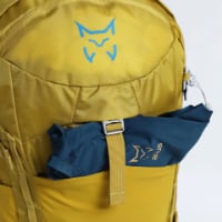
Technical backpack for day trips with backpack cover and internal compartment for the hydration bladder. Ideal daypack for excursions where we need a medium capacity backpack. The back with Air Flow System creates large air channels that will keep our back as cool as possible.

€83,-
Thank you Peregrina2000 and KinkyOne. I will download one of those and see what happens, if it works easily I will use it when the needs be, if not I will just rely on the Amigos guidebook. I have already taken out all the pages from Zamora onwards (using the printout from CaminoGuide.net).
KinkyOne I will do an occasional post either on Camino Live or on my blog. You can always PM me.
Regards and thanks Dermot.
 
Frustration, I downloaded the Wikiloc app and also paid for navigation pack. Spent four hours and really getting nowhere. The ref no on the two links you gave Peregrina came in handy and downloaded those stages but after that there is no complete listing of route about 10 stages some of which seem repeated and nothing to show which order they come. I will appreciate any info of anyone who used Wikiloc on entire route or as far as Zamora otherwise I will use maps.me and they will be some help. Again thanks to Perigrina 2000 and Kiny One.
There may be some one out here who has used Wikiloc on this route.
Dermot
 
Dermot, last year when Susanna and I were planning our walk on the Camino Olvidado, we found that by searching on wikiloc for each individual stage we could find a number of tracks. The user whose tracks I've listed above, joaquinfs, has 22 stages of the Levante listed, up to Gotarrendura, a stage beyond Avila.

Then by searching on the wikiloc site, using Gotarrendura, you'll find several for the next stage to Arevalo: http://www.wikiloc.com/wikiloc/view.do?id=7121369

and so on.

BTW, I also found a complete Valencia to Zamora GPS track there as well: http://www.wikiloc.com/wikiloc/view.do?id=5512935

Having a GPS as a backup on these untraveled caminos can be a real help in a pinch. I'm working on getting some tracks on the device for my walk this summer, at least for the parts where I won't see anyone else.

Hope this helps, but maybe I'm not understanding your issue correctly. Laurie
 
The focus is on reducing the risk of failure through being well prepared. 2nd ed.
Laurie thank you so much, I will later on today download those and I am sure they will be a great help. You put so much useful detail in you reply.
Dermot
 
Laurie thank you so much, I will later on today download those and I am sure they will be a great help. You put so much useful detail in you reply.
Dermot
Although I don't walk by GPS that told me where to go (I prefere maps as such when available) I would be very interested what you came up with wikiloc files.
Many thanks in advance!
 
Hello KinkyOne, I haven ever used any form of GPS and just bought a smartphone for the first. On Camino routes of which I done many I don't even use maps. I tear out the pages of my days walk and put them in my pocket I refer to them when I need and just follow waymarking, I have always been able to eat and find a bed. Because I barely speak any Spanish I just thought it might be useful to have backup. Today in Ireland where I live I brought the phone with me and tried to locate where I was. I found it difficult to read the screen and the technology was slow locating where I was.
The simple use I can see for myself and maybe for you, simply check our location as per the gps and then reference it as per the guidbook to get back on track.

I just looked quickly at the Peter Robbins maps and in the next week will look further at them.
My aim is to play it simple few pages of torn out guide book in pocket and follow the arrows. If I get lost and cant find any help will try gps.
 
Join our full-service guided tour and let us convert you into a Pampered Pilgrim!
I just looked quickly at the Peter Robbins maps and in the next week will look further at them.
My aim is to play it simple few pages of torn out guide book in pocket and follow the arrows. If I get lost and cant find any help will try gps.
Before setting out I got very excited by all the wikiloc etc maps on the Levante and downloaded all sorts of stuff onto my new android 'phone and tablet. When I actually got lost (eg between San Clemente and Las Pedroñeras) I found I couldn't read the maps off-line, so they were no help at all. Almost certainly a combination of age, willful computer-illiteracy and fat thumbs. But I wouldn't rely on anything other than a compass, the sun, the arrows and a guide book (and of course, any passing locals).
 
Before setting out I got very excited by all the wikiloc etc maps on the Levante and downloaded all sorts of stuff onto my new android 'phone and tablet. When I actually got lost (eg between San Clemente and Las Pedroñeras) I found I couldn't read the maps off-line, so they were no help at all. Almost certainly a combination of age, willful computer-illiteracy and fat thumbs. But I wouldn't rely on anything other than a compass, the sun, the arrows and a guide book (and of course, any passing locals).
I'm completely with you on that ;)
I'm fortunate to have kind of implemented GPS and while picking wild mushrooms even on completely unknown terrain I never got lost so far. But while walking the Camino my mind winds away and I could walk for 10 kilometers just enjoying the scenery and going completely off-track. No problem with that whatsoever but in the summer I could get very short on the water, that's my main concern. You never know when the farmer on a tractor will pass by ;)
I'll find a way how to upload off-line Camino tracks onto my Android. Well, not me, but someone will, hahaha
 
Hi Alan'
I used a Nexus 7 on the Sureste/Levant. If you dig around on google maps there may be option to save maps for use off line in conjunction with gps, possibly an option on your tablet?
Regards
George
 
New Original Camino Gear Designed Especially with The Modern Peregrino In Mind!

❓How to ask a question

How to post a new question on the Camino Forum.

Forum Rules

Forum Rules

Camino Updates on YouTube

Camino Conversations

Most downloaded Resources

This site is run by Ivar at

in Santiago de Compostela.
This site participates in the Amazon Affiliate program, designed to provide a means for Ivar to earn fees by linking to Amazon
Official Camino Passport (Credential) | 2024 Camino Guides
Back
Top