• For 2024 Pilgrims: €50,- donation = 1 year with no ads on the forum + 90% off any 2024 Guide. More here.
    (Discount code sent to you by Private Message after your donation)
  • ⚠️ Emergency contact in Spain - Dial 112 and AlertCops app. More on this here.

Search 69,459 Camino Questions

HELP -- from Buiza till Arbas del Puerto

GunnarW

Active Member
Time of past OR future Camino
2011+ > Spain, Belgium, France
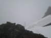
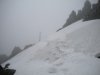
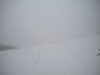
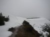
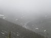
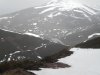
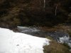
And here we are again to discuss on an important section of the Camino del Salvador.
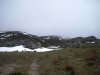
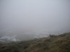
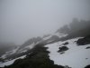
Buiza till Arbas del Puerto.
This is the first section in the mountains. Only Poladura de la Tercia has an albergue and a casa rural/bar.
Can all of you write down your adventures on this section?
When did you walk this section? What did you see? Did you go wrong?
And off course, pictures!
I will come back with a temporary map.
 
Last edited:
Get a spanish phone number with Airalo. eSim, so no physical SIM card. Easy to use app to add more funds if needed.
I'm on my phone so will write more later. The bit I had a moment of confusion with was after the big San Salvador marker post. When the track goes up to the top of the ridge there are a series of yellow markers leading away to the left (west). These are gas line markers, not Camino markers, there is a point where you first see them that is very tempting to cut across country and pick this trail up but dont try to be lazy :) Stick to Ender's route.
 
Okay. :)
Here is the "Ottos short cut" problem.
We were approaching Arbas, and here we had just climbed under the barbed wire. But I think it's Busdongo down the valley?ImageUploadedByCamino de Santiago Forum1382432674.999108.jpg
Ok, before we came to the barbed wire, there was a sign telling us that one can turn left, instead of going under the wire. We did not do that. We continued on the camino, to begin with.
This is how it looks when you look down.
ImageUploadedByCamino de Santiago Forum1382432827.864375.jpg

And when you look at the right:ImageUploadedByCamino de Santiago Forum1382432903.056792.jpg

And to the left:
ImageUploadedByCamino de Santiago Forum1382432955.237543.jpg
Please note the little narrow path. The one that is above the other two. Thats not the Camino. That's the one we took, the short cut. The one in the middle is the camino.

Right. This is where I realised the path was no more after having walked it for a while:
ImageUploadedByCamino de Santiago Forum1382433142.289997.jpg

(to be continued)
 
Last edited:
Technical backpack for day trips with backpack cover and internal compartment for the hydration bladder. Ideal daypack for excursions where we need a medium capacity backpack. The back with Air Flow System creates large air channels that will keep our back as cool as possible.

€83,-
Ok. Then I managed to get myself down to the path in the middle. While Otto continued. As I was standing on top, before the camino was going down again, waiting for Otto, I heard someone shouting. That was Otto, standing on top of this hill: ImageUploadedByCamino de Santiago Forum1382433465.302986.jpg
Then Otto came walking down looking very pleased with the gps in his hand saying: that was 1620 meter!
And if we had gone to the left before the barbed wire, we would maybe have walked on top of the mountain, and then on that way (to the right on the pic), instead of under barbed wire, down and then up again. :)
 
Last pic, to make it clearer where we were. This is after the adventure hill. We were now going down the hill again. So on top of the camino there are three paths, one is the camino coming up the hill, one is the one Otto walked from the 1620 m top, and this is the third which is going down to Arbas. ImageUploadedByCamino de Santiago Forum1382434418.582370.jpg
 
Hello Susanna,

Let's try to understand what happened first.
First, did you see this beauty?
arbas-1.jpg
The camino follows the yellow dots. The second picture connects the first picture.
Before going up again, you had to go through a small bush, no big deal. I added how it was like.
At the cross, the start of a the path uphill, there was - I think - a wooden marker. I'm not sure anymore. In the small bush, I think we noticed a painted arrow on a stone.
I think you struggled in the red area by following the red dots as on your picture you see clearly the GSM cellular phone antenna.

arbas-2.jpg
 
€2,-/day will present your project to thousands of visitors each day. All interested in the Camino de Santiago.
Question a) No, I'm afraid I missed the bull. :D

b) yes it was in the red area. But the red path started much higher up. At about the same level as the bulls ear. :) I saw an old yellow arrow on one on the stones on the ground, in the beginning. But the path got more and more narrow, until it was all bush.

And. Otto thinks one can walk on top of the mountain all the way. Which means walking in the upper left corner on your bull-pic.
 
Get a spanish phone number with Airalo. eSim, so no physical SIM card. Easy to use app to add more funds if needed.
I've found the road which is one the last pic I posted! The one to the right, where Otto walked.:)
You can see it both on google earth and bing maps.
It follows the ridge of the mountain, and seems to end at the very top.
But I can't see if there's a path between that place and the barbed wire sign. There has to be, as there was a sign there, pointing towards something. Wonder if someone else saw it. It was just before the barbed wire, say 10-20 to the left.
You had to leave the path and walk uphills to read it.
 
I followed Ender's route and signage. My biggest issue were the snow drifts. It had rained and they turned to ice. I would walk along the edge until the peaks and then slide down the backside on my pack. This occurred at the pass by the cross and several times thereafter. I also had a lot of water to deal with. Some of the paths up the mountains were streams of water (prior to Poladura de la Tercia) and several places along the path to Arbas. I walked in early April of this year and do not recommend walking this section alone in the snow. I will see if I can find some pictures, this section is where my camera died. For those that do not know, the fences coming out of Buiza are electric. I crossed under them because the paths were so muddy and water filled. Then got chased from the fields by the horses and received a few shocks.

Ultreya,
Joe
 
Join our full-service guided tour and let us convert you into a Pampered Pilgrim!
We walked in September, in a heat wave of 34 degrees, which was challenging in its own way! We did get lost a few times, and I think in the same place Susanna is talking about. John climbed up, I turned left and got around the barbed wire, and eventually saw a yellow arrow, John was able to cut across and join me. We got lost coming into Arbas del Puerto, the signs seemed to run out, I'm not sure if we should have continued going up, but we climbed over a barbed wire fence, with a stone wall, crossed two fields, and came up onto the road just before the Meson, ( which was closed, but we knocked and got the keys to the church)and the church.
We ran out of water between Buiza and Polodura, mainly because it was so hot, so it would be worth carrying some extra.
We stayed in La Posada del Embrujo, in Poladura. Really lovely place to stay, and the food was amazing! 16 euros, but worth it.
Generally we found this section fairly well marked, and when we got lost, it didn't take too long to get back on track.
 
On to the next mapping challenge! Like Joe, I didn't have any real issues on this stretch (but unlike Joe, I was walking in springtime, not in high snowdrifts!). I remember one barbed wire fence on the way down to ARbas, but I just pushed my pack underneat first and then crawled on my belly. It was clearly blocking the camino, so I just continued on. Based on your descriptions, I didn't encounter barbed wire in the places were fortview and Susanna did.

Ender told me when I met him the next day that there are owners on the stretch between Poladura and Pajares who routinely put up barbed wire just to interfere with pilgrims. He usually brings wire cutters when he goes on this part to cut them down (but only those wires that interfere with the camino) because he knows where the route should be open by law. So it may be that these barbed wire blockages are a moving target. If I get a good description of where it interferes with the Camino, I can send it on to Ender and advise him of the location.

I'll see if I can dig up some pictures of this stage when I'm at my computer where the pictures are. Laurie
 
Joe,

have you ever tried Yaktrax? They are a simple walking crampon system that strap over any boot or shoe. They dont have spikes, instead they've got coils of stainless wire on the sole. Good for both solid snow and ice, not as good as true crampons but still improve your grip. I used them last winter on a few walks and they work very well. Might be worth considering for anyone trying the route early or late in the year. They pack down small and not too heavy.

It was hard enough in summer, you've really got my respect. That must've been hard (and quite rewarding I imagine).
 
Technical backpack for day trips with backpack cover and internal compartment for the hydration bladder. Ideal daypack for excursions where we need a medium capacity backpack. The back with Air Flow System creates large air channels that will keep our back as cool as possible.

€83,-
Joe,

have you ever tried Yaktrax? They are a simple walking crampon system that strap over any boot or shoe. They dont have spikes, instead they've got coils of stainless wire on the sole. Good for both solid snow and ice, not as good as true crampons but still improve your grip. I used them last winter on a few walks and they work very well. Might be worth considering for anyone trying the route early or late in the year. They pack down small and not too heavy.

It was hard enough in summer, you've really got my respect. That must've been hard (and quite rewarding I imagine).

Stuart:

Thank you for the suggestion. I will look into Yaktrax.

I had nothing to penetrate snow drifts. I walk without poles. Sliding down on my backpack worked. It was stopping that worried me. I would not walk again in the snow alone. That said, I do look forward to walking this route again in better conditions.

Fortview:

Thirty-fours degrees, wow, that is really hot. I would not enjoy that.

In regards to La Posada del Embrujo, how many Pilgrims can this private Albergue accommodate?

I did have to climb over/under a barb wire fence on the down hill into Poladura.

Ultreya,
Joe
 
In regards to La Posada del Embrujo, how many Pilgrims can this private Albergue accommodate?

Hi Joe,
I wouldn't like the snowy conditions either! You were very brave to walk in that!
This Pension probably sleeps around 14 people . It's private rooms with bathroom, and very nice. Costs 42 euro for a double room.Helen
 

Attachments

  • image.jpg
    image.jpg
    1.2 MB · Views: 18
The 2024 Camino guides will be coming out little by little. Here is a collection of the ones that are out so far.
Gunnar:

I have about a dozen pictures or so you might be able to use. If you would like, please send me your email and I will forward them to you.

jpflavin@msn.com

Joe
 
Technical backpack for day trips with backpack cover and internal compartment for the hydration bladder. Ideal daypack for excursions where we need a medium capacity backpack. The back with Air Flow System creates large air channels that will keep our back as cool as possible.

€83,-
I am not sure how to download pictures here or I would share some of my trip with all of you. My pictures provide a very different but still beautiful view.

Joe
 
Last edited:
Hello Joe,
I forwarded you my email adress.
If you want to download pictures here from the forum, you can right click with your mouse on the picture and select "Save picture as".
 
The one from Galicia (the round) and the one from Castilla & Leon. Individually numbered and made by the same people that make the ones you see on your walk.
To go back to the Susanna-meets-Otto-point.
The brown marker on the picture should point to the right.
In fact there is no straight. This can be confusing if there is fog/low visibility and you don't have an overview on the N630 with Arbas del Puerto.
arbas-4.jpg
 
Joe,

have you ever tried Yaktrax? They are a simple walking crampon system that strap over any boot or shoe. They dont have spikes, instead they've got coils of stainless wire on the sole. Good for both solid snow and ice, not as good as true crampons but still improve your grip. I used them last winter on a few walks and they work very well. Might be worth considering for anyone trying the route early or late in the year. They pack down small and not too heavy.

It was hard enough in summer, you've really got my respect. That must've been hard (and quite rewarding I imagine).

Stuart:

I looked up Yaktrax and found them on the REI site. I will check them out next time I stop there. Thank you for the tip.

Joe
 
3rd Edition. More content, training & pack guides avoid common mistakes, bed bugs etc
My Pictures Poladura to Arbas. Slightly different than Laurie's^^.
 

Attachments

  • 347.JPG
    347.JPG
    2.1 MB · Views: 31
  • 348.JPG
    348.JPG
    2.2 MB · Views: 37
  • 349.JPG
    349.JPG
    2.2 MB · Views: 33
  • 350.JPG
    350.JPG
    2.1 MB · Views: 33
  • 351.JPG
    351.JPG
    2.2 MB · Views: 31
  • 353.JPG
    353.JPG
    2.1 MB · Views: 27
  • 354.JPG
    354.JPG
    1.9 MB · Views: 29
  • 355.JPG
    355.JPG
    2.1 MB · Views: 32
  • 356.JPG
    356.JPG
    2.1 MB · Views: 30
  • 357.JPG
    357.JPG
    2 MB · Views: 28
Join our full-service guided tour and let us convert you into a Pampered Pilgrim!
Thank you Joe to publish your pictures. This is very interesting. Now we see this section when the snow is melting. And it's still challenging to go through. How should it be in full winter?
Also the pictures from Laurie are very nice. Especially the one just above the church at Arbas.
 
My first clue that this must have been an incredible challenge were the several pictures showing yellow arrows painted on rocks pointing you to continue on through rushing water. Then came the white-outs. Then came the icy paths. I think you should forego your April walking tradition the next time you walk the Salvador, Joe.
 
Laurie:

That is the only time I really have to walk that does not interfere with golf season :). The walk was quite challenging in places and should be done, imo, with a partner in the snowy months.

Your pictures were stunning.

Joe
 
Technical backpack for day trips with backpack cover and internal compartment for the hydration bladder. Ideal daypack for excursions where we need a medium capacity backpack. The back with Air Flow System creates large air channels that will keep our back as cool as possible.

€83,-
Before I will disappear for one week.
Let's go back to Buiza. Both pictures were taken when you leave Buiza. The place Buiza is in fact where the first yellow dots are situated. The small picture comes from http://www.santiago-compostela.net/salvador/en_sa02.html and is the situation from 2009-2010, when Laurie and Fatma did their Camino del Salvador. You see a mine in the middle. Both ladies must remember this, no?
3545-buiza.jpg

Today, it's all cleaned up. Another work from Ender?

03350-BUIZA-uitzicht-klein.jpg

The camino (yellow dots) is going around the place where the mine was.
Where I put a blue thunder, there is water running over the camino. Not nice to go through. I remember I went on the meadow right and joined the camino after +/- 50m. I had to go under a barbered wire.
When I took this picture, I was asking myself if there would not be an alternative. Alternative 1 ends in the middle of a field. But if I'm not wrong, it's possible that there was a path coming from Buiza and joins the camino at point 2. Impossible to see in this picture. Wouldn't that be an alternative to save some mud?
 
image.jpg This looks like the same spot Gunnar. I don't remember any problems here, just a path where you suggest. And no going under barbed wire here. Maybe this bit is already improved? Helen
 
Last edited:
The one from Galicia (the round) and the one from Castilla & Leon. Individually numbered and made by the same people that make the ones you see on your walk.
And then you go up this path, and negotiate this wonderful gate!
Amazing, these photos compared to the ones Joe posted!
 
I am having a hard time separating my memories from my Salvador in 2010 and my Salvador in 2012, but these pictures are helping. I think I remember that in 2012 there was still some mining going on outside of Buiza, but the more recent photos suggest that it's all covered up now. So I guess my bad memory isn't a problem in this instance since we know for certain that the mining pit is gone. I don't think Ender had anything to do with this, though he is a miner!
 
Laurie:

That is the only time I really have to walk that does not interfere with golf season :). The walk was quite challenging in places and should be done, imo, with a partner in the snowy months.

Your pictures were stunning.

Joe

Joe, we may have to reconsider your status as a founding member of the Salvador addicts club if you tell me that golf is more important than the Salvador.
 
Ideal sleeping bag liner whether we want to add a thermal plus to our bag, or if we want to use it alone to sleep in shelters or hostels. Thanks to its mummy shape, it adapts perfectly to our body.

€46,-
Laurie:

That is the only time I really have to walk that does not interfere with golf season :). The walk was quite challenging in places and should be done, imo, with a partner in the snowy months.

Your pictures were stunning.

Joe

You know what Mark Twain said about golf and walking :D

Those pictures are amazing! I don't know whether to say "well done" or "you're nuts"! Did you have any trouble with route finding or following the markers? I remember there being a lot of low lying markers on the way to Poladura de la Tercia and thinking this must be really hard going in winter.
 
Joe, we may have to reconsider your status as a founding member of the Salvador addicts club if you tell me that golf is more important than the Salvador.

Laurie:

There is a time and place for all good things.

The early Spring is the best time to walk, in my case, for several reasons. Golf is something I enjoy once a week with some old friends. I also have yard maintenance (grass cutting, garden planting, and Spring clean-up etc.) that needs to be done on a regular basis. These items do not become a regular activity until late April. Therefore, in order to stay in my wife's good graces, I walk in the early Spring.

Joe
 
The 9th edition the Lightfoot Guide will let you complete the journey your way.
You know what Mark Twain said about golf and walking :D

Those pictures are amazing! I don't know whether to say "well done" or "you're nuts"! Did you have any trouble with route finding or following the markers? I remember there being a lot of low lying markers on the way to Poladura de la Tercia and thinking this must be really hard going in winter.


Stuart:

I believe He said, "Golf is a good walk spoiled".

I did not plan to walk in these conditions. I was working with Laurie and the Spanish Salvador group and received some conflicting weather reports. I remember posting when I arrived in Pajares that I did not recommend anyone walk this route at that time.

Either statement "Well done or You're nuts" :) would probably qualify. A lot of the markers are a meter high and some places the route is pretty intuitive. Given a choice, I would choose to walk in Laurie's conditions.

Joe

I really do have so much respect for you continuing when you hit conditions like that. I've only once hit stuff like that unexpectedly on a Highland walk and it was a real challenge when not geared up for it. You could see snow on the Ubinas when I was there and was actually pretty glad I had fallen behind and couldn't do my diversion there.

Hope I didn't offend with the golf line, the golfing vs. walking paradox was crying out for it :) I used to be a ski bum in Canada in winter in a place that only existed because summer golfers kept it going so I'm very grateful to the game!
 
To go back to the Susanna-meets-Otto-point.
The brown marker on the picture should point to the right.
In fact there is no straight. This can be confusing if there is fog/low visibility and you don't have an overview on the N630 with Arbas del Puerto.
View attachment 6557

Hi, all,
I just got a note from Ender, and he asked that I let the map wizards know that there is a slight error going on in this discussion.

The camino actually IS straight ahead. To the right, you will go towards the antennas, but it is overgrown.

To the left you will eventually join up with the path that goes straight ahead.

Bottom line -- at this point, follow the Cuatro Valles brown marker straight ahead.

I am having a hard time remembering this point, but Ender says it is right after you have gone over the Sierra del Cuchillo and you can see the Colegiata de Arbas below in the distance.

More discussion, please! Do any of you have a better memory than I? (I think that probably goes without saying).
 
3rd Edition. More content, training & pack guides avoid common mistakes, bed bugs etc
Hi, all,
I just got a note from Ender, and he asked that I let the map wizards know that there is a slight error going on in this discussion.

The camino actually IS straight ahead. To the right, you will go towards the antennas, but it is overgrown.

To the left you will eventually join up with the path that goes straight ahead.

Bottom line -- at this point, follow the Cuatro Valles brown marker straight ahead.

I am having a hard time remembering this point, but Ender says it is right after you have gone over the Sierra del Cuchillo and you can see the Colegiata de Arbas below in the distance.

More discussion, please! Do any of you have a better memory than I? (I think that probably goes without saying).

Thank you Laurie, for this important post about stuff that really matters. :)
Ok, having said that, so ....eh? Did anyone go wrong here?
There is only one way forward and that is down, no?
That's where I went, and it was a wide trail. Almost a road.
 
hi, Susanna, you know me, always happy to help keep the conversation going about the Salvador. ;)

Well, Gunnar's post says that you should go to the right and not straight down. So I'm assuming you did go straight down and had no problems. Gunnar, why did you say that the better way was to go to the right?

Or have I misunderstood everything?
 
I'm a bit lost now. Are we talking about after where you hit the ridge and start the descent towards the the phone antenna on the outcrop on the left?
 
New Original Camino Gear Designed Especially with The Modern Peregrino In Mind!
I'm a bit lost now. Are we talking about after where you hit the ridge and start the descent towards the the phone antenna on the outcrop on the left?

Yes. I'm confused now. :(
Who went to the antenna instead of Arbas and why?
 
Yes. I'm confused now. :(
Who went to the antenna instead of Arbas and why?

Am I thinking of the right place? You come over the ridge where you see Busdongo down in the valley. Off to the left there is a phone antenna on an outcrop and you follow a path towards it. I cant recall if the path reaches it but one of my guides (not the CSJ) says walk towards it.
 
Am I thinking of the right place? You come over the ridge where you see Busdongo down in the valley. Off to the left there is a phone antenna on an outcrop and you follow a path towards it. I cant recall if the path reaches it but one of my guides (not the CSJ) says walk towards it.

I know what you mean. That is the place I took pics from, see #3 in this thread. :)
But that's not the place Gunnar is talking about in #25!
That is the next hill. You start where you can see Busdongo, you walk down, then up again, towards the antenna. Then you are at the spot in Gunnars pic. Then you start walking down again.
Hmm. Must confess I have forgotten what we were talking about. There was some kind of problem but I don't remember what.
 
A selection of Camino Jewellery
I can't remember this either! And I don't recall a problem at this spot...
We got lost at Laurie's photo# 19 . Completely lost the arrows there. That's where we ended up having to climb over barbed wire and a wall and cross 2 fields. But that's probably just us, no one else seems to have had a problem there.
 
Last edited:
Ah ok I'm back on track :)

I dont remember the spot unfortunately.

I walked this section referring to map and compass as it was clouding over and worried about a fog coming down. I'll dig my maps out and see if I'd noted my track.

And Rachel, I've not forgotten to post them! :)
 
Get a spanish phone number with Airalo. eSim, so no physical SIM card. Easy to use app to add more funds if needed.
The first town I saw on this route was Busdongo. I had the same disheartening feeling when I realized it was not my goal. As I recall, the trail veered to the left around the mountain away from Busdongo and the towers.
 
Down bag (90/10 duvet) of 700 fills with 180 g (6.34 ounces) of filling. Mummy-shaped structure, ideal when you are looking for lightness with great heating performance.

€149,-
Busdongo is a real option, for lunch or lodging, if you´ve had enough mountain-climbing for the day, or if (like me) you see a storm coming at you. Just continue down down down the trail, and be really careful with that railway crossing...
 
Here I am again - me and my lost memory... ;)
Well, where to start and with what?

- the mine: yes, I do remember it VERY well. What an ugly place inmidst all this beauty. Good to hear, it has been 'arranged'

- reaching Poladura following the wooden markers. This worked well till just the last km (now, there is the little bridge, before we just searched how to find our way)

- Poladura to Arbas:
When Maria, another solo female walker, and me were leaving the albergue (july 2010), the weather was just fine. Arriving a little higher in the mountains, near to the huge flat meadow, we first didn't see any markers, nor did it seem the right way to follow the pipeline. And then suddenly, the fog was descending on the mountains. After a first panic attac, we continued and finally found our way to the top.
I remember well the flat part leading straight to the wire with the view on what appeared to be Busdongo- (here a loss of memory).
I see us descending in curves on the cow meadow (some yellow arrows here and there) before heading towards the antennes. (lacking part)
I remember that at a certain point (some 100 of meters before reaching them), a wooden markers pointed to the left. Then, shortly after, we had to fight our way down through "darty" bushes. And we did not see any sign again, but the N630, the Puerta de Pajares AND the bar (just waiting for us).
Maria shortcutted the walk towards the Puerta and crossed the huge cow (and bull) assembly; I preferred to leave them alone and found another way towards the N630.
We never passed through Arbas...


@Joe: lucky you were, finding your way in these conditions.
And I understand your garden maintenance arguments: this year particularily when I came back, my garden looked like a jungle...
 
Hello,
Here I'm again.
Let's go back to picture #25
I took the picture at "1"
Esmine was standing at "2", in the black circle I draw.
Indeed, the camino is not right. But it's not straight either. It's something like 45° to the right. I would prefer a painted arrow on the wooden mojon pointing at 1 or 2 o' cock.
Maybe it would be a good idea if Ender has a spare metal arrow to plant it on point "2" in case of fog and/or snow?
The Otto path, it should be (close) to the red dots.
The antenna is also placed on the map.
Notice that if you would need to go to Busdongo, the safest and easiest way is to follow the grey dots. At the fifth last dot, there seems to be a small path to the right and a bridge to overpass the railroad.

busdongo-otto.jpg
 
3rd Edition. More content, training & pack guides avoid common mistakes, bed bugs etc
Beautiful, Gunnar, I'm so glad you are back. A pity one can only hit the Like button one time per post. Right now I wish I could hit it like a woodpecker. Tatatatatatata! :)

I will look at my pics if I have one of the part after "2".
I think so.:)
The Otto path looks correct. And do you remember I said there was a yellow arrow on the Otto path? Somewhere between the fifth or the sixth spot. That's interesting.
 
To Fatma,
In 2010, when you walked to Poladura de la Tercia, how did you go over the little river? Did you have to walk over a horizontal tree?

Arbas: the only easy possibility to skip Abras is to stay on the path. To be clear, if you look on the (real) map page 1, where there is a yellow arrow pointing to the top, you followed the path to the LEFT and arrived at the N630.
I don't have a picture but found in Google Street view where the path joins the N630.
Blue dotted: the possible Fatma alternative.
fatma-arbas-alternative.jpg
 
3rd Edition. More content, training & pack guides avoid common mistakes, bed bugs etc
This is what happens next!
This one was a bull.
Ooh, what did we do?
I will post the next picture this afternoon...
bull-stable-2.jpg
 
Meanwhile, let's talk about this intersection at the famous waterhut.
I think Laurie took the first time straight heading to the N630.
How is this alternative till the N630?
waterhut-split.jpg
 
St James' Way - Self-guided 4-7 day Walking Packages, Reading to Southampton, 110 kms
About the bull before Arbas.
Suddenly, he turned away and ran/jumped like crazy.
We didn't do something special to change his mind.
bull-stable-3.jpg
 
Meanwhile, let's talk about this intersection at the famous waterhut.
I think Laurie took the first time straight heading to the N630.
How is this alternative till the N630?
View attachment 6712

Now I'm not with you. That is before Poladura? That must be far away from n-630?
 
Well, you would arrive in Rodiezmo by going straight. In Rodiezmo, you could continue going through Villanueva de la Tercia at the N630 or take a small concrete road to Poladura de la Tercia passing San Martín de la Tercia.
 
The 2024 Camino guides will be coming out little by little. Here is a collection of the ones that are out so far.
Well, you would arrive in Rodiezmo by going straight. In Rodiezmo, you could continue going through Villanueva de la Tercia at the N630 or take a small concrete road to Poladura de la Tercia passing San Martín de la Tercia.
Okay, but Rodiezmo is also far away from n-630? A couple of km?
That's a long extra way.
I'm sure Laurie will tell us when she logs in. She walked that way once, I think.:)

I wonder what you did with the bull. They don't behave like that when I'm around.
They just stare and look bored. :(
 
Meanwhile, let's talk about this intersection at the famous waterhut.
I think Laurie took the first time straight heading to the N630.
How is this alternative till the N630?
View attachment 6712

Yes, that's right. The first time I walked the Salvador was before Ender put up his arrows and shells. The water hut in this picture was infamous for being the spot at which many pilgrims went wrong. (It's actually the second water hut you come upon, I think). Now there are many many arrows and indications that you should take the path Gunnar has marked.

Continuing straight ahead on the wide track takes you down into Rodiezmo, through Villanueva de la Tercia (all of that is fine, and on tracks or country roads)and then out onto the N630 for many hours of unpleasant walking along the side of the road up to the Puerto de Pajares. It was awful -- millions of trucks on a Sunday morning. We definitely should have "turned left" to walk into Poladura de la Tercia on the road from Rodiezmo, but we were kind of all mixed up.

Hope this makes sense! Laurie
 
Ideal sleeping bag liner whether we want to add a thermal plus to our bag, or if we want to use it alone to sleep in shelters or hostels. Thanks to its mummy shape, it adapts perfectly to our body.

€46,-
Are picture #63 and #64 essentially taken at the same spot? Isn't that the same building in both pictures, one up close, one from further back?

Yes, it's the same building. :)
Didn't someone walked the wrong way at Arbas? I wonder if they passed that house.
 
btw, the little purple flowers on the ground, at least the bright yellow stamens in the middle, are where saffron comes from!

Gunnar is right about the alternative path through that cow pasture. If you are not interested in doubling back to see Arbas, you can just follow the little path visible beyond the Raging Bull (pic. 65) and it ends up at the gate in his highway pic (blue dots, pic 62.)
 
We did go wrong at Arbas, but not there. Rebekah it's nice to know about the saffron. We were told that those flowers are the reason for the Salvador being represented by the colour purple as well.
 
New Original Camino Gear Designed Especially with The Modern Peregrino In Mind!
We did go wrong at Arbas, but not there. Rebekah it's nice to know about the saffron. We were told that those flowers are the reason for the Salvador being represented by the colour purple as well.
That's interesting, I didn't know that. That must be why the Salvador scarves are purple. :)
 
Laurie,
Yes, at the second water hut (in fact I never noticed the first one), it's almost impossible to miss the left lane. You see a big yellow arrow on the waterhut. After the bush, there is an Ender metal arrow and on the picture you see the first wooden mojon.
 
Join our full-service guided tour of the Basque Country and let us pamper you!
Susanna,
About the cows/bulls. Your picture of the stable gave me the idea of posting the bull sequence at the same place (in fact, you can see on both pictures the same hill behind)
The bull had a strange behaviour. It seems that it was searching for his cows. It was walking towards us, stood still and ran like crazy when we approached normally.
 
Thats funny, Gunnar. There were no cows or bulls there when I was there. Lots of them outside Buiza, though. Guess they walk over large areas.
Here is a pic of the road to Rodiezmo, I think. I took it when walking uphills after the water hut. Please note, there are wild horses down there. :) (not sure I posted it before, but anyway)
ImageUploadedByCamino de Santiago Forum1383643480.717212.jpg
 
Where we arrived at the little stream, it was quite narrow and it was no problem to pass it. July, hot summer, few water...

As to the way "avoiding" Arbas, yes once the massive vegetations downhill left behind us, Maria followed this path straight to the National road. I just left it some time before towards the right (joining the N630). Your bulls , Gunnar, were already there and they impressed me a lot...

(As to the rest, will check it later. The phone screen is just too small)
 
Last edited:
The 2024 Camino guides will be coming out little by little. Here is a collection of the ones that are out so far.
Yest Fatma, the cows/bulls are diffrent than the ones in our country.
150km +/- south of Compostela, in Portugal - Geres, I met this sweaty.
Would you dare to pass her or him, Susanna?
cow-geres-portugal.jpg
 
Amazing picture Susanna.
The horses you saw in the gorge, I met them +/- 200m before the water hut 2, at the end of the forrest at the right side.
wild-horses-before-waterhut-2.jpg
 
Very light, comfortable and compressible poncho. Specially designed for protection against water for any activity.

Our Atmospheric H30 poncho offers lightness and waterproofness. Easily compressible and made with our Waterproof fabric, its heat-sealed interior seams guarantee its waterproofness. Includes carrying bag.

€60,-
I only saw cows and steer before entering Poladura, and thankfully none on the path afterwards. That was fine with me because I am always a bit nervous when I have to pass them. I try to go as far away as possible but in some places a close encounter is unavoidable. Spaniards always tell me that if they are out roaming untethered, they are not dangerous, but I still don't like it. Are there better or worse ways to pass these guys if you have no alternative other than walking close to them?
 
In first instance, I'm not afraid of a cow/bull. I make a small loop around them if they sit because it's not necessary to disturb them. If there is no way to loop, I carefully walk to them and in general they stand up and walk away.

Meanwhile, I started making the map. It will be 4 pages.
Does someone remembers if there are fuentes? I have one in Buiza center, Poladura center and Arbas center.
 
The map is created and is sent for review to Laurie.
The used satellite maps are a little bit smaller. If I used the same scale as the Puerto de Pajares map, it would be spread over much more pages.
It now contains the situation of the albergues. That's the reason why I updated also the Puerto de Pajares map.
 
The 9th edition the Lightfoot Guide will let you complete the journey your way.
The map is created and is sent for review to Laurie.
The used satellite maps are a little bit smaller. If I used the same scale as the Puerto de Pajares map, it would be spread over much more pages.
It now contains the situation of the albergues. That's the reason why I updated also the Puerto de Pajares map.
Well don't worry about the number of pages.
There is no such thing as too many pages of Salvador stuff. Just bring it on. Loads of it. :)
 
Well Susanna,
[Susanna: Well. I'm going to print out that map and put it on my fridge.]
How many fridges do you have?
Can you post a picture of your fridge(s)?
 
Well Susanna,
[Susanna: Well. I'm going to print out that map and put it on my fridge.]
How many fridges do you have?
Can you post a picture of your fridge(s)?

I got one fridge here in the house, and a smaller one in the flat in the city. The big one here is free to use.:)
It was difficult to get a pic of it, as there are too much stuff in the way.
But you can see it here on page 16, the one to the left:
http://www.miele.se/media/haushalt/vgse/Miele_Broschyr_KylFrys_hosten_2012_2.pdf
It's about 1860x 750 mm.
So at least nine a4 pages on the fridge, and a few one the freezer. :)
 
Very light, comfortable and compressible poncho. Specially designed for protection against water for any activity.

Our Atmospheric H30 poncho offers lightness and waterproofness. Easily compressible and made with our Waterproof fabric, its heat-sealed interior seams guarantee its waterproofness. Includes carrying bag.

€60,-
... and I remember very well the water hut and that I took the small path to the left.
(jihaaah, at least some way found on the Salvador).
 

Most read last week in this forum

(Soon-) Live from the Camino del Salvador - starting end of April 24. We are currently on the Camino de Invierno around 43km before reaching Santiago - from there we will catch a bus to Leon to...

❓How to ask a question

How to post a new question on the Camino Forum.

Forum Rules

Forum Rules

Camino Updates on YouTube

Camino Conversations

Most downloaded Resources

This site is run by Ivar at

in Santiago de Compostela.
This site participates in the Amazon Affiliate program, designed to provide a means for Ivar to earn fees by linking to Amazon
Official Camino Passport (Credential) | 2024 Camino Guides
Back
Top