- Time of past OR future Camino
- Via de la Plata, Portuguese, Ingles, Levante
Hi again, planning my next section of the Camino de Levante, continuing in April from Casas de Los Pinos. So, I am doing some homework in the route especially through many towns and villages that I will pass through on my next visit.
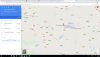
Some of you will have noticed that I posted an interesting chart last year, showing graphically the contrasting routes between Caminos Sureste and Levante, where they converge, diverge and co-exist along the way. I am attaching that map again. In a number of towns, they diverge on separate paths which, by definition means that there two routes out of some towns. Minaya, Tembleque, Toledo etc.
I was studying the route out of Tembleque and there are Camino arrows guiding you out of town from the Cathedral. However, if you follow that path, you will find that you are heading to a town called Vilanueva de Bogas and you actually come across a camino sign which says Camino del Sureste. Sure enough, this route out of Tembleque is on the Camino de Sureste. So, there must be another route out of Tembleque on the Camino de Levante. And another bit of research finds that route heading out (southwest of Tembleque) towards the highway CM-410, this route leading to a town called Mora. Well that makes sense since all the documentation will say that Mora is the next town after Tembleque on the Camino de Levante (25 klm). So problem solved!
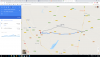
But the puzzling part for me is that, when I search the web, I see that many people walking the Levante actually walk to Vilanueva de Bogas and then on to Mora, effectively walking two sides of a triangle instead of one. I have two GPS tracks, one on "map-me", which include Vilanueva de Bogas on the Camino de Levante and, separately, there is a Camino de Levante blog by a very nice member of this group who walked it in 2013 and, again, walked through Vilanueva de Bogas.
So why do people not go on the direct and official route from Tembleque to Mora which is marked with Camino signs? Perhaps it is to avoid such a long stint without any places to break? Not even sure that there is a marked Camino path from Vilanueva de Bogas to Mora since the natural progression on the Camino del Suresta is from Vilanueva de Bogas on to Almonacid de Toledo?
And to compound the puzzle even more, both caminos converge again in Almonacid de Toledo, so if you go to Vilanueva de Bogas, why would you bother going across to Mora when you will tie up again with the Camino de Levante on Almonacid de Toledo,
If this is confusing then simply put, pilgrims appear to be walking two sides of two triangles (4) instead of one side twice (2). A bit of a puzzle. I think that I will take the direct route to Mora. Your thoghts?
Some of you will have noticed that I posted an interesting chart last year, showing graphically the contrasting routes between Caminos Sureste and Levante, where they converge, diverge and co-exist along the way. I am attaching that map again. In a number of towns, they diverge on separate paths which, by definition means that there two routes out of some towns. Minaya, Tembleque, Toledo etc.
I was studying the route out of Tembleque and there are Camino arrows guiding you out of town from the Cathedral. However, if you follow that path, you will find that you are heading to a town called Vilanueva de Bogas and you actually come across a camino sign which says Camino del Sureste. Sure enough, this route out of Tembleque is on the Camino de Sureste. So, there must be another route out of Tembleque on the Camino de Levante. And another bit of research finds that route heading out (southwest of Tembleque) towards the highway CM-410, this route leading to a town called Mora. Well that makes sense since all the documentation will say that Mora is the next town after Tembleque on the Camino de Levante (25 klm). So problem solved!
But the puzzling part for me is that, when I search the web, I see that many people walking the Levante actually walk to Vilanueva de Bogas and then on to Mora, effectively walking two sides of a triangle instead of one. I have two GPS tracks, one on "map-me", which include Vilanueva de Bogas on the Camino de Levante and, separately, there is a Camino de Levante blog by a very nice member of this group who walked it in 2013 and, again, walked through Vilanueva de Bogas.
So why do people not go on the direct and official route from Tembleque to Mora which is marked with Camino signs? Perhaps it is to avoid such a long stint without any places to break? Not even sure that there is a marked Camino path from Vilanueva de Bogas
to Mora since the natural progression on the Camino del Suresta is from Vilanueva de Bogas on to Almonacid de Toledo? And to compound the puzzle even more, both caminos converge again in Almonacid de Toledo, so if you go to Vilanueva de Bogas, why would you bother going across to Mora when you will tie up again with the Camino de Levante on Almonacid de Toledo,
If this is confusing then simply put, pilgrims appear to be walking two sides of two triangles (4) instead of one side twice (2). A bit of a puzzle. I think that I will take the direct route to Mora. Your thoghts?