• Get your Camino Frances Guidebook here.
  • For 2024 Pilgrims: €50,- donation = 1 year with no ads on the forum + 90% off any 2024 Guide. More here.
    (Discount code sent to you by Private Message after your donation)
  • ⚠️ Emergency contact in Spain - Dial 112 and AlertCops app. More on this here.

Search 69,459 Camino Questions

iOS apps for history guide

Julia Mumford

Adventure Geek
Time of past OR future Camino
Camino Frances (2016, 2017, 2018, 2019)
Camino Ingles (2018)
My daughter (14 years) and I are walking the 2nd part of our Camino in October. We walked St Jean to Estella in June 2016, and we plan to walk for 11 days in October and see how far we get.

One of my regrets from the last adventure was not learning enough about the small towns / churches and history of the places we passed through. I am already at maximum weight, so I was wondering if anyone could recommend an app that gives history rather than another book to carry.

Thank you

Julia
 
St James' Way - Self-guided 4-7 day Walking Packages, Reading to Southampton, 110 kms
Transport luggage-passengers.
From airports to SJPP
Luggage from SJPP to Roncevalles
Consider the ebook/kindle version of the cultural/historical guide which many pilgrims use
The Pilgrimage Road to Santiago by David M Gitlitz and Linda Kay Davidson which is available here on Amazon.

Buen camino!
 
€2,-/day will present your project to thousands of visitors each day. All interested in the Camino de Santiago.
My daughter (14 years) and I are walking the 2nd part of our Camino in October. We walked St Jean to Estella in June 2016, and we plan to walk for 11 days in October and see how far we get.

One of my regrets from the last adventure was not learning enough about the small towns / churches and history of the places we passed through. I am already at maximum weight, so I was wondering if anyone could recommend an app that gives history rather than another book to carry.

Thank you

Julia
Kindle app and you can take all the books you want with you ;-) Buen Camino, SY
Now why didn't I think of that!!! Der!
 
If you're the type of mom who likes to give homework :eek: you can have your daughter do a little research ahead of time, put it in a word document, and download that onto your kindle app also. I made my own version of a guide, with not to miss things in churches or museums, and albergues that I wanted to try to use
 
I'll admit, I always checked with the gronze parrot to make sure I'd not forgotten anything
 
The 9th edition the Lightfoot Guide will let you complete the journey your way.
One of my regrets from the last adventure was not learning enough about the small towns / churches and history of the places we passed through. I am already at maximum weight, so I was wondering if anyone could recommend an app that gives history rather than another book to carry.
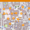
There is an app, OSMand, that is used for offline map and GPS navigation but an additional educational feature is that you can download a Wikipedia plugin for it. Ever notice that many Wikipedia pages have coordinate data attached to them. The plugin will show a symbol for each of these. So you can set OSMand to show Wikipedia sites. Then as you walk by a feature marked with a Wikipedia icon you can click the icon to get a description of the site. The app can be configured to show just icons with an English description or to show icons for sites with either English or native language pages. For example, if you are using just English you might get icons showing up at cathedrals and towns but if you set this feature more broadly you may get the cathedrals and towns but also other stuff in Spanish, Galician, etc. entered by the local Wikipedia editors such as churches, villages, birthplaces of local heroes, sites of not-so-famous battles, etc.

The OSMand app is free with a limited amount of downloads of mapped regions so you can try it out. It is cheap to buy and you get an unlimited number of maps. Unfortunately there are some OSMand features that are complicated. If you are looking for something similar for navigation (no Wikipedia feature) you may prefer maps.me.

Screenshot_20160929-131104.png
 
There is an app, OSMand, that is used for offline map and GPS navigation but an additional educational feature is that you can download a Wikipedia plugin for it. Ever notice that many Wikipedia pages have coordinate data attached to them. The plugin will show a symbol for each of these. So you can set OSMand to show Wikipedia sites. Then as you walk by a feature marked with a Wikipedia icon you can click the icon to get a description of the site. The app can be configured to show just icons with an English description or to show icons for sites with either English or native language pages. For example, if you are using just English you might get icons showing up at cathedrals and towns but if you set this feature more broadly you may get the cathedrals and towns but also other stuff in Spanish, Galician, etc. entered by the local Wikipedia editors such as churches, villages, birthplaces of local heroes, sites of not-so-famous battles, etc.

The OSMand app is free with a limited amount of downloads of mapped regions so you can try it out. It is cheap to buy and you get an unlimited number of maps. Unfortunately there are some OSMand features that are complicated. If you are looking for something similar for navigation (no Wikipedia feature) you may prefer maps.me.

View attachment 29372
luckily you will be walking with a 14 year old who can handle all of that
 
The focus is on reducing the risk of failure through being well prepared. 2nd ed.
Consider the ebook/kindle version of the cultural/historical guide which many pilgrims use
The Pilgrimage Road to Santiago by David M Gitlitz and Linda Kay Davidson which is available here on Amazon.

Buen camino!

I'll second this one. So much history, art, architecture, all specific to the Camino Francés. Wonderful resource.
 
Brilliant! This is exactly what I was looking for. It took me a while to figure out that you pull it up to get the Wikipedia content, but this is brilliant. Thank you so much.


There is an app, OSMand, that is used for offline map and GPS navigation but an additional educational feature is that you can download a Wikipedia plugin for it. Ever notice that many Wikipedia pages have coordinate data attached to them. The plugin will show a symbol for each of these. So you can set OSMand to show Wikipedia sites. Then as you walk by a feature marked with a Wikipedia icon you can click the icon to get a description of the site. The app can be configured to show just icons with an English description or to show icons for sites with either English or native language pages. For example, if you are using just English you might get icons showing up at cathedrals and towns but if you set this feature more broadly you may get the cathedrals and towns but also other stuff in Spanish, Galician, etc. entered by the local Wikipedia editors such as churches, villages, birthplaces of local heroes, sites of not-so-famous battles, etc.

The OSMand app is free with a limited amount of downloads of mapped regions so you can try it out. It is cheap to buy and you get an unlimited number of maps. Unfortunately there are some OSMand features that are complicated. If you are looking for something similar for navigation (no Wikipedia feature) you may prefer maps.me.

View attachment 29372
 
Consider the ebook/kindle version of the cultural/historical guide which many pilgrims use
The Pilgrimage Road to Santiago by David M Gitlitz and Linda Kay Davidson which is available here on Amazon.

Buen camino!
Margaret, I will send you you a PM.
 
€2,-/day will present your project to thousands of visitors each day. All interested in the Camino de Santiago.

Most read last week in this forum

La Voz de Galicia has reported the death of a 65 year old pilgrim from the United States this afternoon near Castromaior. The likely cause appears to be a heart attack. The pilgrim was walking the...
This is my first posting but as I look at the Camino, I worry about 'lack of solitude' given the number of people on the trail. I am looking to do the France route....as I want to have the...
The Burguete bomberos had another busy day yesterday. Picking up two pilgrims with symptoms of hypothermia and exhaustion near the Lepoeder pass and another near the Croix de Thibault who was...
Between Villafranca Montes de Oca and San Juan de Ortega there was a great resting place with benches, totem poles andvarious wooden art. A place of good vibes. It is now completely demolished...
Left Saint Jean this morning at 7am. Got to Roncesvalles just before 1:30. Weather was clear and beautiful! I didn't pre book, and was able to get a bed. I did hear they were all full by 4pm...
Hi there - we are two 'older' women from Australia who will be walking the Camino in September and October 2025 - we are tempted by the companies that pre book accomodation and bag transfers but...

❓How to ask a question

How to post a new question on the Camino Forum.

Similar threads

Forum Rules

Forum Rules

Camino Updates on YouTube

Camino Conversations

Most downloaded Resources

This site is run by Ivar at

in Santiago de Compostela.
This site participates in the Amazon Affiliate program, designed to provide a means for Ivar to earn fees by linking to Amazon
Official Camino Passport (Credential) | 2024 Camino Guides
Back
Top