Search 74,075 Camino Questions

Is that OK to use Google maps for Camino Frances?

Time of past OR future Camino
Going for Camino walk this Nov.
Hello, I have downloaded few camino apps and bought paid one too. But I just don't know how to use them. Is that OK to use Google maps? I noticed that the route suggested by Google maps is different from the Camino Frances maps that I downloaded to Google maps. But I don't know how to navigate camino frances way with Google maps. I am starting to walk the last 100km of Camino Frances today fr Sarria.
 
Ideal pocket guides for during & after your Camino. Each weighs only 1.4 oz (40g)!
For the last 100 km it should be possible to follow the yellow arrow waymarks quite easily. Alternatively, follow the many other pilgrims following the same path. If you enter your start point and destination into Google maps, it will show you the quickest route on foot but this may not be the same as the camino, so if you can't find the waymarks or other pilgrims to follow, take the Camino Francés route you downloaded. If you look lost, local people will point you in the right direction. Good luck and buen camino.
 
Not really. It will lead you off the Camino onto roads.
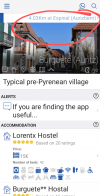
I like the free Buen Camino app. It shows the Camino route with your position on it. Or if you wander off you can clearly see how to get back on. It also shows you the distance to the next town in a banner across the top.

A map app that does have the Camimo routes built in is mapy.cz

 
Ideal sleeping bag liner whether we want to add a thermal plus to our bag, or if we want to use it alone to sleep in shelters or hostels. Thanks to its mummy shape, it adapts perfectly to our body.

€46,-
As Dick has said, google maps will give you the fastest route which is often on the highway/main roads. Whereas the Camino will mostly try to keep walking pilgrims off the highway. From Sarria a lot of the time you’ll be walking parallel to a national road, but on a dirt trail next to it, and not on the actual road.

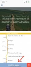
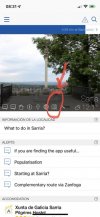
Here are some screenshots from Buen Camino app, cos I use it a lot too and it’s free, I hope this helps.

2D295500-E555-445A-80EE-67B96C387872.jpeg

Once you have downloaded the route you can click the current town you’re in.
C7320B1F-A1F0-485D-82AC-73C6081291A8.jpeg
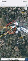
Click on the map/chart icon to take you to the live GPS position. Your current location will be a blue dot. Then you can see if you’re on the route or off route. You will also see route alternatives etc.
B435D235-8239-4997-96AA-2256C60E4637.jpeg
It’s a good idea to read/plan tomorrow’s walk the night before, so you have some ideas of the distance you’ll do, any alternative/worthwhile detours… etc.

For example, if you finish today in Portomarin, tomorrow you’ll likely do Portomarin-Palas de Rei, after about 2h walk you’ll see a detour to Castromaior, I’d suggest you take it if you can.
 
Hello, I have downloaded few camino apps and bought paid one too. But I just don't know how to use them. Is that OK to use Google maps? I noticed that the route suggested by Google maps is different from the Camino Frances maps that I downloaded to Google maps. But I don't know how to navigate camino frances way with Google maps. I am starting to walk the last 100km of Camino Frances today fr Sarria.
It's not a wilderness trail, just follow the yellow arrows and keep an eye on the pilgrims in front. It's normal to be nervous about it all but it's easy when you start walking.
Enjoy and Buen Camino.
 
Are you able to find someone who is prepared to let you walk with them, even if only for a couple of hours? If you can, I would give up trying to use an app for the moment, and learn how to follow the waymarks with a 'guide' who is prepared to help you do that. You might also be able to find someone who is prepared to give you a little assistance with the apps that you have loaded once you have stopped for the day if you are staying in albergues. If they are not too busy, a hospitalero might have time to help you get started for the next day, or an app if they are familiar with it, but they might have other things to do and not be able to spend much time with you on this.

NB. I had this happen to me walking to Muxia and Fisterra a few years ago. I was quite happy to have someone walk with me for the first hour or so of the day. Four days later, we were still walking together into Fisterra.
 
...and ship it to Santiago for storage. You pick it up once in Santiago. Service offered by Casa Ivar (we use DHL for transportation).
Hello, I have downloaded few camino apps and bought paid one too. But I just don't know how to use them. Is that OK to use Google maps? I noticed that the route suggested by Google maps is different from the Camino Frances maps that I downloaded to Google maps. But I don't know how to navigate camino frances way with Google maps. I am starting to walk the last 100km of Camino Frances today fr Sarria.
I used Google maps to direct me to my accommodation and that worked perfectly fine , but I never used a map for the Frances as I found it very well signposted but did look at the camino Ninja from time to time to see how far I was away from the next calling point and what shops if any did they have .
 
I've always wondered why Google doesn't see the hundreds of thousands of people walking across Spain to Santiago and suggest the actual camino as a walking path. (It's gotta be in their data.) But, no, it seems they only suggest roads for walking, and often busy roads. I just asked Google how to walk from St. Jean to Santiago. Here's what it suggested: https://goo.gl/maps/WW5dtfQD6gRDoUAS8 If you used Google suggestions you'd miss many of the great places on the camino such as Leon and Burgos, including all the wonderful towns between Pamplona and Burgos. (Although I'm sure you didn't intend to do it that way. :)
 
You CAN... but it is better to use a Camino specific map app. Most of the Camino apps have a map in them. I also use "far out" for the Camino. The "far out" app is free, but you do have to pay for the map you need. They have the Frances, and it was quite accurate and was great for seeing the primary and alternate routes, elevation gains/losses, water sources, etc. "Far out" is created for backpackers though - so it has all of the "HIKING" information you need - but a Camino specific app will give you more information like which albergues are in each town.

Google maps gives great map directions - but not necessarily always following a walking path. Still - I use it in the cities to find my way around cities.
 
€2,-/day will present your project to thousands of visitors each day. All interested in the Camino de Santiago.
The first edition came out in 2003 and has become the go-to-guide for many pilgrims over the years. It is shipping with a Pilgrim Passport (Credential) from the cathedral in Santiago de Compostela.
Hello, I have downloaded few camino apps and bought paid one too. But I just don't know how to use them. Is that OK to use Google maps? I noticed that the route suggested by Google maps is different from the Camino Frances maps that I downloaded to Google maps. But I don't know how to navigate camino frances way with Google maps. I am starting to walk the last 100km of Camino Frances today fr Sarria.
I used google Maps only as reassurance, don't using a book. The way is well marked, especially from Sarria to SdC.

If you do the CdS from Sarria, just follow the other pilgrims and you will arrive in SdC after 4-6 days happily.
 
Hello, I have downloaded few camino apps and bought paid one too. But I just don't know how to use them. Is that OK to use Google maps? I noticed that the route suggested by Google maps is different from the Camino Frances maps that I downloaded to Google maps. But I don't know how to navigate camino frances way with Google maps. I am starting to walk the last 100km of Camino Frances today fr Sarria.
All you need to do is follow the arrows and shell signs. I walked my first Camino without a guide book, and have never used an app - just look out for arrows, it really is that simple.
 
I needed google a couple times to help me find my way out of town. I think Ponferrada was the worst (though I might be confusing it with another city). I simply could not find the shells, and I slowly accumulated other lost pilgrims. We knew generally which direction we were supposed to be heading, but that was it. Google can also help finding an albergue if it's one of the smaller ones. But other than that, I agree with all the others - it won't help you once you're on the trail.
 
Join the Camino cleanup. Logroño to Burgos May 2025 & Astorga to OCebreiro in June
I think Ponferrada was the worst (though I might be confusing it with another city). I simply could not find the shells,
Snap! 8-) I've passed through Ponferrada three times and lost the signed route each time! I just headed in roughly the right direction until I picked up the signs again.
 
Now that the immediacy of the original request has passed, and we might expect that the OP is now well on the way to SDC, I will put a plug in for my preferred mapping tool, OSMAnd from the Open Street Maps organisation. They also have an Apple version. Both use the extensive mapping collected over the years as a public domain data set. On the Android version, that includes the many walking and cycling trails in Spain and Portugal, and I presume elsewhere in Europe. It also has route planning tools that I find work well for walking, cycling and most other major transport modes. I used it extensively earlier this year when I was narrow boating in Cambridge and Norfolk, and then on the Camino do Tejo to Fatima, and the Camino Portuguese route from Tomar to SDC.

The advantage of a general mapping tool to me is that it more readily adapts to the circumstance where specialist apps like Wise Pilgrim haven't reached. I think Wise Pilgrim, etc are more likely to give better results on the well established routes, where the aggregation of mapping, accommodation and other useful information in one place can be a clear advantage.
 
€2,-/day will present your project to thousands of visitors each day. All interested in the Camino de Santiago.
Hello, I have downloaded few camino apps and bought paid one too. But I just don't know how to use them. Is that OK to use Google maps? I noticed that the route suggested by Google maps is different from the Camino Frances maps that I downloaded to Google maps. But I don't know how to navigate camino frances way with Google maps. I am starting to walk the last 100km of Camino Frances today fr Sarria.
camino places app.jpeg
I'm a huge fan of Google Maps, but in 2019 it just didn't work for hiking scenerios, so I used "Camino Places" It worked flawlessly and there's really nothing to do other than select the route you want. In my case, it was the Camino Frances. It automatically showed me on the map as a blue dot. If I ever needed to see where my exact location was, I just clicked on the little black arrowhead on the bottom right of the app screen and the map would shift/move to show my location-(blue dot) at the center of the map. You'll see that I have booking.com, uber and Airbnb app icons right next to Camino Places. I used all of those apps for my camino. Airbnb was used only to pre-book my stay in SJPP and Uber to get from the train station to my hotel in Madrid before I left home. Booking.com was excellent for booking private rooms on the camino.
 
Now that the immediacy of the original request has passed, and we might expect that the OP is now well on the way to SDC, I will put a plug in for my preferred mapping tool, OSMAnd from the Open Street Maps organisation.
For me the biggest advantage of the Open Street Maps data base is that it shows trails that don't appear in Google Maps. Also the data is free for apps to use so, in addition to their OSMAnd app, base maps for Wikiloc, Organic Maps and Maps.me have access to the same information. Other apps likely do also.

I don't push these apps as much as I should. If you learn to use these instead of (or in addition to) the camino specific apps you can find interesting places to walk near your home.

I use OSMAnd mostly but I have other apps as well. I have recommended Maps.me here in the past because it doesn't have as many features as OSMAnd and so it is easier to use. Try Organic Maps now though. It is built from the same code as Maps.me by the same people but doesn't have the same privacy invasion.
 
Perfect memento/gift in a presentation box. Engraving available, 25 character max.
Hello, I have downloaded few camino apps and bought paid one too. But I just don't know how to use them. Is that OK to use Google maps? I noticed that the route suggested by Google maps is different from the Camino Frances maps that I downloaded to Google maps. But I don't know how to navigate camino frances way with Google maps. I am starting to walk the last 100km of Camino Frances today fr Sarria.
For walking the Camino, you do not need Google Maps ... at least not for Camino Frances because it is well marked every step of the way; however staring in Astorga I began using Google Maps to locate my albergue and it's worth familiarizing yourself with it as some albergues, hostels, pensions may be located on nearby streets from the Camino and could be difficult to locate.
 
On my Camino Catalan I used Wikiloc to ensure that I stayed on track, occasionally used OSMAnd to get a broader picture of distance and Google Maps when approaching a town to see if there was something of interest that might be hiding a short distance from the camino.
 
€2,-/day will present your project to thousands of visitors each day. All interested in the Camino de Santiago.
We just walked the Frances. We used Wise Pilgrim. Gronze, Mapy, and Apple Maps. Each had it’s forte. Mapy is scary accurate. So accurate it shows fonts and picnic tables ahead. Gronze shows distance between towns and mileage and lodging in each town. Wise Pilgrim shows Camino and lodgings. Apple shows businesses.
 
Now that the immediacy of the original request has passed, and we might expect that the OP is now well on the way to SDC, I will put a plug in for my preferred mapping tool, OSMAnd from the Open Street Maps organisation. They also have an Apple version. Both use the extensive mapping collected over the years as a public domain data set. On the Android version, that includes the many walking and cycling trails in Spain and Portugal, and I presume elsewhere in Europe. It also has route planning tools that I find work well for walking, cycling and most other major transport modes. I used it extensively earlier this year when I was narrow boating in Cambridge and Norfolk, and then on the Camino do Tejo to Fatima, and the Camino Portuguese route from Tomar to SDC.

The advantage of a general mapping tool to me is that it more readily adapts to the circumstance where specialist apps like Wise Pilgrim haven't reached. I think Wise Pilgrim, etc are more likely to give better results on the well established routes, where the aggregation of mapping, accommodation and other useful information in one place can be a clear advantage.
I am trying to learn OSMAnd. I have had success a few times and very much enjoy seeing all of the surrounding trails.
 
...and ship it to Santiago for storage. You pick it up once in Santiago. Service offered by Casa Ivar (we use DHL for transportation).
You can use any app you want. But - google maps doesn't show the actual route unless you found a Camino route that has been added google maps to download.

I recommend downloading Wise Pilgrim, Buen Camino, or any other Camino specific app that has maps and play with them and learn how to use them. Then you can always see where you are in relation to the actual trail (wheras on google maps you see where you are, but don't necessarily see where the trail is unless you found one that happens to use google maps). The Camino map apps are all very simple to use - just play with them and figure them out. Or look for a youtube tutorial - I am willing to bet they exist.

But - for the most part - it is super easy to follow arrows and shells. There are a few places where I felt I needed to pull out a Camino map app to find the trail, but a majority of the time you shouldn't need an app. I use mine as backup only. Also - locals are very helpful usually, sometimes they are the ones to tell you that you missed a turn somewhere.

But - if you are using google maps - without a downloaded Camino route - then you can just ask for directions to the next town if necessary. Might not be the actual route - but you are bound to find the arrows somewhere along the way. Especially in smaller towns.
 
Hello, I have downloaded few camino apps and bought paid one too. But I just don't know how to use them. Is that OK to use Google maps? I noticed that the route suggested by Google maps is different from the Camino Frances maps that I downloaded to Google maps. But I don't know how to navigate camino frances way with Google maps. I am starting to walk the last 100km of Camino Frances today fr Sarria.
You've probably figured it out by this time but in case you haven't, then I suggest not using Google maps as your sole navigator. Instead use it in conjunction with "Camino Ninja" App
This App is simple to use and will keep you on track with the Camino trail.
Google maps always finds the shortest route for you to walk so it may take you through the ugliest landscapes, roads and slums just to save time. Whereas Ninja keeps you on the scenic path of Camino and in touch with fellow travelers, Alberges and pilgrim food/beer vendors. Bon Camino to you!
You could also use Wise Pilgrim or Buen Camino, two other popular Camino apps. An advantage of these apps is that you can download the map before setting out, so that you do not use data during the day while you are consulting them.

I have often found that it is handy to also have a more general purpose map application that is primarily for walkers (like Organic Maps, Wikiloc, or Mapy.cz) which can be handy in finding good walking routes between any two points, if I want to take a detour to see something or go somewhere not right on the Camino.
 
Get a spanish phone number with Airalo. eSim, so no physical SIM card. Easy to use app to add more funds if needed.

❓How to ask a question

How to post a new question on the Camino Forum.

Most read last week in this forum

Asking for friends planning to walk the Frances from SJPP tp SdeC in 2025. What were folks who have walked during summer/fall 2024 been spending per day? They are a couple preferring a private...
Hello everyone, I hope you are well! I did the Camino Ingles last year and it was an amazing spiritual experience. This year, with many personal changes coming up, i feel the need to walk for a...
I'm currently staying near Oviedo, in the north of Spain. I know there are various Camino trails near here but I can't find any using Google maps and Google searching. Is it possible to find...
Hello, has anyone been to the Sahagun street market. Do you know if they close promptly at 2:00pm (I'll be walking there on a Saturday). What kind of stands/boothes are there (food, cheese...
Reading https://www.caminodesantiago.me/community/threads/ruins-of-a-tower-between-hontanas-and-castrojeriz.89457/ reminded me of a tower near Azqueta. I don't think I was on this forum back...
Hi fellow wanderers, I would like a bit of input on this one please. I have finally decided to revisit the Camino Frances next year. I walked SJPDP to Santiago solo in 2016 and walked from...

Featured threads

❓How to ask a question

How to post a new question on the Camino Forum.

Featured threads

Forum Rules

Forum Rules

Camino Updates on YouTube

Camino Conversations

Most downloaded Resources

This site is run by Ivar at

in Santiago de Compostela.
This site participates in the Amazon Affiliate program, designed to provide a means for Ivar to earn fees by linking to Amazon
Official Camino Passport (Credential) | 2024 Camino Guides
Back
Top