• Get your Camino Frances Guidebook here.
  • For 2024 Pilgrims: €50,- donation = 1 year with no ads on the forum + 90% off any 2024 Guide. More here.
    (Discount code sent to you by Private Message after your donation)
  • ⚠️ Emergency contact in Spain - Dial 112 and AlertCops app. More on this here.

Search 69,459 Camino Questions

Map recommendations

Ella88

New Member
Time of past OR future Camino
Planning May - June 2016
Hello there. This is my first time posting on here, although I've gathered a wealth of knowledge and advice from this forum which has helped me prepare for my upcoming Camino. I will be leaving from SJPP on May 17th and have given myself 6 weeks to get to Santiago.

I've done a fair bit if travelling before, although nothing like a walking pilgrammage! I would like to avoid getting a guidebook as my impression of the Camino is that you don't have to be especially organised in terms of planning stages in advance if you don't want to. Part of the enjoyment of this walk for me will be surrendering that temptation to plan and to be enjoy the journey as it unfolds in real time.

Anyway, the point of this is that I wanted to ask for recommendations on maps. I see that a lot of guide books say that they include detailed maps. I've found an up-to-date and very detailed list of alburgues along the route, so I really just need a guide to following the route from each town. If it's not too naive a question, is it possible to turn up and follow signs along the way? How well marked is it? I would feel more secure with a map in anycase. I don't mind digital or paper form.

Thanks in advance :)
 
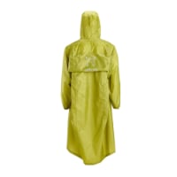
Very light, comfortable and compressible poncho. Specially designed for protection against water for any activity.

Our Atmospheric H30 poncho offers lightness and waterproofness. Easily compressible and made with our Waterproof fabric, its heat-sealed interior seams guarantee its waterproofness. Includes carrying bag.

€60,-
The Camino Frances is very well signposted and you could probably walk it from end to end without any maps. Many people do. I like to have access to maps though, especially if I take a detour off the route for any reason. There are several smartphone apps which show the Camino superimposed on Google Maps or Open Street Map. These will link to a phone's GPS to show you exactly where you are in relation to the route. Very helpful and some are free. I found MiCamino very useful. There are several others very similar. They also give information on albergues, bars and other useful information. Worth a try if you plan on carrying a smartphone.
 
The Camino is signposted well so you don't really need a map.

That said - I was glad I had the TrekRight app on my phone. It doesn't need data to run and uses your GPS to get your location with a blue dot. It was just nice to "know" that I was on the right path and how much longer I had to go at times.
 
A selection of Camino Jewellery
I started my first Camino in SJPdP with no guidebook or map and was going to just use the elevation charts and albergue list they give you at the pilgrim's office. I found a guidebook on a donativo table and ended up using it. It was helpful, but not 100% necessary.
If you don't want to haul around a book, there's a couple of map only guides out there.
In all likelihood if you don't bring a map/guide of any kind you will end up frequently asking to look at one's carried by fellow pilgrims.
 
Last edited by a moderator:
I found the maps in the Brierley guidebook to be quite adequate. I'm normally a map freak, and seldom go on any hike without a detailed map, but walking the Camino is not rocket science, and Mr Brierley's simple maps (supplemented by a hundred thousand or so painted yellow arrows) were more than sufficient to keep me on the right path, show me what lie ahead, and summarize lodging opportunities along the way.
 
True, guidebooks are not necessary but I'd suggest some kind of map/Albergue list in case you find the one Albergue in town has no more room. It'd be nice to know how far it is to the next one. Brierley, for example, has just a maps book but it notes albergues on it.
 
The one from Galicia (the round) and the one from Castilla & Leon. Individually numbered and made by the same people that make the ones you see on your walk.
Transport luggage-passengers.
From airports to SJPP
Luggage from SJPP to Roncevalles
OK, I am an engineer. I have been studying maps a number of guidebooks, loading cell phone apps, GPS paths, Google Earth/Google Map satellite and street views. I have come to a conclusion of sorts.

I will take a couple of guidebooks with me with notes on places I want to visit or stay (churches, special Albergues, museums, works of art, wineries, etc.) I will also take a GPS with some way points/paths loaded to make sure I know where those things are so I can get to them and not walk past them.

In looking at maps and such going through many towns and cities, I at first worried that I would miss my turn at a particular intersection. Sometimes it was clear on Google Street view that the turn was well marked, other times I couldn't see marks. I have since concluded that it is not important to follow the "right street" as there isn't a "right street." The marked path in some places changes from what I have read over time.

So I am beginning to understand that it is more about the journey than the path. I want my Camino to allow me to see many things, but if a road is flooded, muddy beyond belief, I will detour around the problem. If someone tells me about a special sight that I really should see that is a slight detour, I may take the detour. While I originally wanted to plan every detail, I am now beginning to just want to experience things. Still the thought of missing special places is troubling to me.

My GPS is more to show me where I am, allow me to contemplate how much farther I want to go in a day, where restaurants/bars and grocery stores are located, than to guide me down the right path. The same with the guide books and maps.

Good luck.
 
I think that a distances chart (so you can decide how far you want to go) and list of (recommended) albergues is all that you will need.
Albergues are clearly indicated, and most places are little villages, anyway. Most probably, after some days you will be walking or at least dining with an informal group, so you can just go with them. Generally, it works well.
There are 4 o 5 variants or alternatives in the Camino frances that may be worth considering. Just look them in advance.
That said, if you like e-maps or guides, just bring the one you like more. There is ample info on this forum.
But remember, the "what if..." is the easiest path to an overweight backpack.o_O
 
At the start of the CF (SJPP) you will be able to pick up a stage map with elevation profiles for the entire Camino. With the alburgue list you already have map per se is not necessary. Trails are well marked and often I just follow the crowd ahead of me for reference. I used the Michelin map guide, similar to the Brierley's, just for looking up accommodation options.
 
The one from Galicia (the round) and the one from Castilla & Leon. Individually numbered and made by the same people that make the ones you see on your walk.
On the Le Puy route, I found the maps in Miam Miam Dodo to be quite sufficient. I normally won't go on a hike without a good topo map, and the MMD maps aren't really all that detailed (they're 1 cm = 375 m). But they were good enough that I could tell which direction the next turn was, and about how far away it was. With the excellent balisage (markings) along GR65 in France, that was quite sufficient. It seems like the markings are at least as good, if not better, along the Camino Frances. This isn't an orienteering exercise, nor wilderness navigation.

And if you think you might be off course, the locals in France are generally very friendly and happy to help get you back on course (especially if you ask in French). Be sure to add "Bonjour, monsieur. S'il vous plait, ou est le GR soixante-cinq?" to your list of phrases to learn if you walk that route. From what I've read, the people are pretty much the same in Spain. Let's see, in Spanish it would be "Buenas dias, senor. Por favor, donde esta el Camino de Santiago?" or something very similar. That's probably all the map you will need. :)
 
Get a spanish phone number with Airalo. eSim, so no physical SIM card. Easy to use app to add more funds if needed.

Most read last week in this forum

La Voz de Galicia has reported the death of a 65 year old pilgrim from the United States this afternoon near Castromaior. The likely cause appears to be a heart attack. The pilgrim was walking the...
Just reading this thread https://www.caminodesantiago.me/community/threads/news-from-the-camino.86228/ and the OP mentions people being fined €12000. I knew that you cannot do the Napoleon in...
I’m heading to the Frances shortly and was going to be a bit spontaneous with rooms. I booked the first week just to make sure and was surprised at how tight reservations were. As I started making...
This is my first posting but as I look at the Camino, I worry about 'lack of solitude' given the number of people on the trail. I am looking to do the France route....as I want to have the...
My first SPRINGTIME days on the Camino Francés 🎉 A couple of interesting tidbits. I just left Foncebadón yesterday. See photo. By the way, it's really not busy at all on my "wave". Plenty of...
I was reading somewhere that some of us are doing night walks. As a natural born night owl I would love to do such walk too. Of course I can choose stage by myself (CF). But was wondering if any...

❓How to ask a question

How to post a new question on the Camino Forum.

Forum Rules

Forum Rules

Camino Updates on YouTube

Camino Conversations

Most downloaded Resources

This site is run by Ivar at

in Santiago de Compostela.
This site participates in the Amazon Affiliate program, designed to provide a means for Ivar to earn fees by linking to Amazon
Official Camino Passport (Credential) | 2024 Camino Guides
Back
Top