Search 69,459 Camino Questions

Maps for the primitivo

3rd Edition. More content, training & pack guides avoid common mistakes, bed bugs etc
I walked the Primitivo earlier this year. I used Liz Brandt's downloadable guide - on here somewhere! - and found that with it and the fairly good waymarking I rarely needed a map. On the rare occasions when I needed one I used a mapping app on my smartphone. Very useful for entering and leaving towns when it can be easy to miss signposts. There is an app with the unpromising name of "Soviet Military Maps" which gives easy access to Google maps, Bing maps and the really useful Open Street Map and Open Cycle Map. Very handy for when your navigation is not quite 100% :)
 
Leave the map at home, or better yet don't buy them. After all you will not be walking one roads, at least not a lot. They will not be useful in anyway.
 
Get a spanish phone number with Airalo. eSim, so no physical SIM card. Easy to use app to add more funds if needed.
that's great guys, thanks for replying. Just as I thought.
not planning out the days too much, have to get to Santiago by the 25th July (in 15 days) so just wanted to have some options to vary the days if needed but if GPS maps work that will do (wasn't sure about getting reception out there). does anyone know if its easy to not do the Hospitales route, I know it would be spectacular but I'm really not sure my knees are up to it or that I will have time so just wondered if the alternative is well marked?
 
My phone used the Movistar network and there was reception almost everywhere. I usually viewed my next day's route over a cold beer in the evening and took screenshots of any parts that might be needed. That way they were available even if I lost reception on the way. I recommend Open Cycle Maps because it has detailed scalable and shaded contour maps which make it easy to visualise the route. The Primitivo is not marked on the map as such but when you read the route guides it is usually fairly obvious where it must be.

I met quite a few people who walked via Pola de Allande rather than the Hospitales route. No one said that they had any problems with route markings. The point where the routes divide is well marked with a signpost and information board. My understanding is that the Pola de Allande route is the "official" trail while the Hospitales route is a signposted alternative. I'd expect it to be easy to follow.
 
Jools, you don't need GPS either. While this route is not as travelled it is far from remote. But reception can be an issue. I certainly was without reception more often than not (Vodaphone on an Iphone). I would buy a paper guide or take printouts or the Eroski maps for exemple.

Not doing the Hospitales route will cost you an extra day of walking. It also means a day going down on roads and a day going up, up and up. It is very well marked from what I gather. Not sure which route would be kinder to your knees. For me the decision to take the Hospitales route was based on the weather: if it was good I would do it, if there was any change it would not be nice, I was taking the extra day.
 
New Original Camino Gear Designed Especially with The Modern Peregrino In Mind!
Thanks Anenome - so is the hospitals route shorter? I was lead to believe it was longer
 
I met quite a few people who walked via Pola de Allande rather than the Hospitales route. No one said that they had any problems with route markings. The point where the routes divide is well marked with a signpost and information board. My understanding is that the Pola de Allande route is the "official" trail while the Hospitales route is a signposted alternative. I'd expect it to be easy to follow.

Se llama "hospitales" porque pasa al lado de las ruinas de unos antiguos hospitales para peregrinos, así que no sé si se estaría bien considerarla como ruta alternativa. Las dos rutas se pueden considerar como oficiales.

It's called "hospitales" that runs alongside the ruins of an ancient hospital for pilgrims, so I do not know if it would be good to consider it as an alternative route. The two routes can be regarded as official.
 
Thanks Anenome - so is the hospitals route shorter? I was lead to believe it was longer

Let's see. Editorial Buen Camino has Hospitales as 22km or so. Borres to Pola as 14.4, then Pola to Berducedo as 17,47. Add 3 km of starting from Campielo.

Cicerone says 27 km from Campielo to Berducedo via Hospitales. From Campielo to Pola 10 and to Berducedo it doesn't say but those who went that way never arrived in Berducedo in the evening so must have atayed in Pola.

Now keep,in mind that the volunteers in Tineo were laughing at distances given in our guides: where Cicerone says 12 from Tineo to Campielo they say 14, to Borres 3.9 and mot 2.3 km. They say guides keep distances short not to scare us away

Go see what Eroski has to say. It doesn't have these as perfect etapas so you'll have to do a bit of math. and take a look at Liz's,guide on the forum for other info.

Just found a picture from the Tineo Council, it has Hospitales as being 14.2 km from the split in the road where you need to decidevwhere to go, 3 km after Borres, to Puerto de Palo, the last pass. Apparently the split is in Samblisimo and from there to Pola it says it's 10 km, then you need to head to Berducedo.
 
Last edited by a moderator:
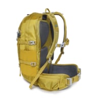
Technical backpack for day trips with backpack cover and internal compartment for the hydration bladder. Ideal daypack for excursions where we need a medium capacity backpack. The back with Air Flow System creates large air channels that will keep our back as cool as possible.

€83,-
Ok thanks for that I will take a close look - I guess I got worried when reading Liz current blog where she says going the hospitals route was a day of 36km but then they are planning on doing the whole journey in a shorter time than I
 
http://www.rtpa.es/asturias:Allande...enda-del-camino-de-Santiago_111434628313.html

Allande inaugura una nueva senda de El Camino de Santiago

Concluyen las obras de mejora con la plantación de 150 árboles

Allande ha inaugurado hoy una nueva senda que se integrará dentro del recorrido de El Camino de Santiago.

Finalizadas las obras de mejora, esta senda estará jalonada por 150 árboles que cuando crezcan servirán para dar sombra a los peregrinos.

En la iniciativa han participado los escolares de la zona encargados de plantar los robles, abedúles y hayas, además de haber realizado una parte del recorrido.

Una actividad que contribuye en ese proceso que 'El Camino' ha iniciado para ser declarado Patrimonio de la Humanidad.
 
A selection of Camino Jewellery
I was scared of the Hospital route - silly of me - but I walked to Pola, then took a taxi to the top of the mountain, and joined the point where both routes meet, and walked down. The walk down was challenging (fearful), I would guess it required much more effort than any other part of the whole Primitivo route.

Liz's guide is fine. Waymarkers great - I only needed to check her guide to see how many more hills before the albergue ;-)
 
. . . . . .
Now keep,in mind that the volunteers in Tineo were laughing at distances given in our guides: where Cicerone says 12 from Tineo to Campielo they say 14, to Borres 3.9 and mot 2.3 km. They say guides keep distances short not to scare us away . . . . . . .

I found that quote most interesting as it reflects my experience exactly! I note that in 2009 when I first walked the Primitivo, I made it 14 kilometers from Tineo to Campielo :)
I have done the math on the relative distances from several guides etc. and reckon that the Hospitales route is about 2 kilometers shorter. The difference between the two is that there is no accommodation on the Hospitales route between Borres and Berducedo. Going via Pola de Allande means an extra day if, like most using that route, you stay over in Pola.

To go back to the original post:- The Michelin maps are pretty useless for walkers. The only bought maps worth having are the "Mapas Militar" - the Ordnance Survey maps of Spain. They are available in the U.k. from The Map Shop, Upton on Severn. You don't need them anyway unless you want to go "off piste" as we did on the Ruta do Mar.

blessings
Tio Tel
 

Most read last week in this forum

Hi all! Started today from Oviedo to Escamplero. Now I know, why so many people say it's a bit of a challenge to come out of Oviedo. I got lost just once, but was rescued by a very friendly guy. A...

❓How to ask a question

How to post a new question on the Camino Forum.

Forum Rules

Forum Rules

Camino Updates on YouTube

Camino Conversations

Most downloaded Resources

This site is run by Ivar at

in Santiago de Compostela.
This site participates in the Amazon Affiliate program, designed to provide a means for Ivar to earn fees by linking to Amazon
Official Camino Passport (Credential) | 2024 Camino Guides
Back
Top