• Get your Camino Frances Guidebook here.
  • For 2024 Pilgrims: €50,- donation = 1 year with no ads on the forum + 90% off any 2024 Guide. More here.
    (Discount code sent to you by Private Message after your donation)
  • ⚠️ Emergency contact in Spain - Dial 112 and AlertCops app. More on this here.

Search 69,459 Camino Questions

Maps

7wood

Member
Time of past OR future Camino
2013 SJPP to Pamplona. 2014 Pamplona to Burgos. 2015 Burgos to Sarria. 2016 Sarria to Santiago de Compostla,Finisterre,Muxia. 2016. 2017 Porto to ???
Where can I get an O.S. map of the walk from Cruceiro to Roncesvalles. Would I need one if mist or clouds closed in?
 
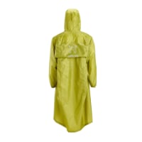
Very light, comfortable and compressible poncho. Specially designed for protection against water for any activity.

Our Atmospheric H30 poncho offers lightness and waterproofness. Easily compressible and made with our Waterproof fabric, its heat-sealed interior seams guarantee its waterproofness. Includes carrying bag.

€60,-
If you want a paper or electronic version then I did a recent post giving a step by step on how to download the file for printing from the IGN website. Give me 5 minutes and I'll post the link.
 
The focus is on reducing the risk of failure through being well prepared. 2nd ed.
O.S. is Ordinance Survey; same as Spanish 'Mapas Militar'. The name comes from the time when the army ordinance officers were the map makers; round the time of Napoleon. They are still the official maps here.
 
Thanks Cruceiro according to John Brierley is where you leave the D428 and start walking into the hills
 
New Original Camino Gear Designed Especially with The Modern Peregrino In Mind!
If you have Brierley, that is all the map you need. Just follow the yellow arrows.:)
You don´t need any map on the Camino Frances , just follow the yellow arrows.
It really depends on when you are walking and how likely you are to miss an arrow. I wonder if those who offer 'just follow the arrows' as advice have ever been in the circumstance where they have missed an arrow and spent time lost. Its not pleasant. Without a decent map, the only real option is re-tracing one's steps and trying to find where the arrow was you missed. I have had to do that and it's not pleasant. Brierley is good while you are on the right path, hopeless if you are not, but at least you will know generally where to look for the turns and when to start being concerned if you haven't seen an arrow for a while.

I found that many of the other pilgrims who made much of not taking a guidebook would borrow a guidebook in the evening to get a good idea of what the following days walk would be like. Its difficult to plan out a day without some idea about what places the path will pass through, whether there are particularly interesting things to look out for, whether there is a bar/cafe, etc. That is where I found Brierley particularly valuable.

Regards,
 
Ideal sleeping bag liner whether we want to add a thermal plus to our bag, or if we want to use it alone to sleep in shelters or hostels. Thanks to its mummy shape, it adapts perfectly to our body.

€46,-
It really depends on when you are walking and how likely you are to miss an arrow. I wonder if those who offer 'just follow the arrows' as advice have ever been in the circumstance where they have missed an arrow and spent time lost. Its not pleasant. Without a decent map, the only real option is re-tracing one's steps and trying to find where the arrow was you missed. I have had to do that and it's not pleasant. Brierley is good while you are on the right path, hopeless if you are not, but at least you will know generally where to look for the turns and when to start being concerned if you haven't seen an arrow for a while.

I found that many of the other pilgrims who made much of not taking a guidebook would borrow a guidebook in the evening to get a good idea of what the following days walk would be like. Its difficult to plan out a day without some idea about what places the path will pass through, whether there are particularly interesting things to look out for, whether there is a bar/cafe, etc. That is where I found Brierley particularly valuable.

Regards,

I´m a mountain hiker. I hike every weekend of the year, rain or shine. And I can tell you that without a compass a map is useless.

I have walked 3 Caminos, without a guide book, without a map. And YES I missed an arrow or two. But I didn't get lost, I investigated and saw more than many who DID see the yellow arrow. You just have to keep your calm and retrace your steps.

I also have followed a fellow peregrino instead of looking for the yellow arrows and I also ended up going the wrong way. I had to retrace my steps as well.But this is part of the Camino.


I have observed on the forum that there are lots of people who are too book/guide dependent ." They don´t see the woods for the trees." They miss out on lots of things as they walk along the Camino. They have their guide book and they think it´s like the Holy Bible - word of God. All that ´s written in it is correct .
No need to ask anyone local or peregrinos as the Almighty Guide Book has all the answers. The Camino is much more than follow a book. But everyone follows their own Camino.

I wish you well on yours.:)

Un abrazo & Buen Camino!
 
It really depends on when you are walking and how likely you are to miss an arrow. I wonder if those who offer 'just follow the arrows' as advice have ever been in the circumstance where they have missed an arrow and spent time lost. Its not pleasant.

I know what you mean. I just started out from Ponte de Lima in Portugal and missed an arrow while I was distracted by 6 beautiful young Portuguese girls who started talking to me (each had a flower in her hair). Went about a quarter of a mile and came to a split in the road, and no arrow!!! It was extremely unpleasant because I had to walk back through the mass of drunks coming from an all night music festival. But I lived to see another day!!!!
 
I´m a mountain hiker. I hike every weekend of the year, rain or shine. And I can tell you that without a compass a map is useless.
I bushwalk regularly too, and long ago learnt the skill of orienting the map to the ground without the aid of a compass. This is more often than not sufficient to work out where I am without having to resort to using a compass and doing a resection.

On the CF in 2010, I found it an advantage to have reasonable OS style mapping on my GPS, which allowed me to find my way without back tracking on several occasions. In 2012, I use the OS style mapping provided for the Norse Pilgrim Centre for St Olav's Way on a Nokia smartphone. The screen size was a little small, but I was still able to orient myself using it.

I agree it is not essential to have OS style maps, but on both CF and St Olav's Way, I found it beneficial to have access to better mapping than was provided by Brierley or its equivalents.

Regards,
 
Technical backpack for day trips with backpack cover and internal compartment for the hydration bladder. Ideal daypack for excursions where we need a medium capacity backpack. The back with Air Flow System creates large air channels that will keep our back as cool as possible.

€83,-
I´m a mountain hiker. I hike every weekend of the year, rain or shine. And I can tell you that without a compass a map is useless.

I have walked 3 Caminos, without a guide book, without a map. And YES I missed an arrow or two. But I didn't get lost, I investigated and saw more than many who DID see the yellow arrow. You just have to keep your calm and retrace your steps.

I also have followed a fellow peregrino instead of looking for the yellow arrows and I also ended up going the wrong way. I had to retrace my steps as well.But this is part of the Camino.


I have observed on the forum that there are lots of people who are too book/guide dependent ." They don´t see the woods for the trees." They miss out on lots of things as they walk along the Camino. They have their guide book and they think it´s like the Holy Bible - word of God. All that ´s written in it is correct .
No need to ask anyone local or peregrinos as the Almighty Guide Book has all the answers. The Camino is much more than follow a book. But everyone follows their own Camino.

I wish you well on yours.:)

Un abrazo & Buen Camino!

I think I annoyed Dougfitz on a previous thread about navigating the Frances :D but you're experience is very similar to mine and I stick by my comments. Navigating the Frances isn't a huge challenge. I do a lot of mountain walking and the idea of going without a map & compass seemed like anathema but I walked with no guide either. The only places I got lost were in a couple of the larger towns. On the other hand I took a full set on the Salvador and kept a plot of my position as I went across the mountains as even though it's very well marked it's still pretty remote, wild terrain and I could imagine bad weather really making navigation difficult.

I've been lost before and a few times in harsh conditions (mountain blizzards), it's not pleasant. Everyone needs to make their own risk assessment though and decide what they want to get out of it i.e. if you end up following another route does it invalidate your experience? I found the unknown enhanced the experience. More than a few people tried forcing guides on me, one woman tried to give me her map, a guy who became a very good friend damn near marched me into a shop and tried to make me buy a copy of Brierley. I held out though :) Seeing people studying guides in the evening, making notes, walking from the bottom of the page to the top... not for me. I probably missed out on a few sights and a bit of background but I felt like I was discovering as I went.

I do think Dougfitz's idea of electronic mapping is the most practical if you're taking maps, 800km of even 1:50k maps is a hell of an investment. On the other hand, I hate GPS with a passion, I much prefer paper and a compass.
 
Seeing people studying guides in the evening, making notes
It beats an iPod and music for using up time; and you often meet very nice people who are curious about the next day.:)

In France I buy maps because the route often is unnecessarily circuitous and I need maps to find the short cuts. We used Google Maps on an iPhone on the last Chemin du Puy, and ran up a $600 data charge on ATT international service! You can buy a lot of maps for that amount...
 
I think I annoyed Dougfitz on a previous thread about navigating the Frances :D but you're experience is very similar to mine and I stick by my comments.
You did:rolleyes:. I don't think your advice was framed in the context that you are now offering, which makes it difficult for a tyro to assess whether they have similar skills and experience, and can take the same risks as you are prepared to take. But you are no alone in this. In trying to make our posts succinct, it often happens that we don't provide all the details we might.

It is much the same as some multi-camino veterans who give similar advice. It makes me wonder if they would have been so blase about how easy it is on their first camino. I, too, might choose to walk without a guidebook if I had done the CF several times. As it was, I was glad I took a guidebook on my first camino, and intend to do the same next year when I walk a different route for the first time.

Regards,
 
Ideal sleeping bag liner whether we want to add a thermal plus to our bag, or if we want to use it alone to sleep in shelters or hostels. Thanks to its mummy shape, it adapts perfectly to our body.

€46,-
Interesting Doug,how do you orientate a map to the ground,without a compass,in dense bush,or desert ?.......:confused:.......Vicrev
 
It beats an iPod and music for using up time; and you often meet very nice people who are curious about the next day.:)

True.

In France I buy maps because the route often is unnecessarily circuitous and I need maps to find the short cuts. We used Google Maps on an iPhone on the last Chemin du Puy, and ran up a $600 data charge on ATT international service! You can buy a lot of maps for that amount...

Ouch! I do a lot of caving in France and decent mapping is important for finding sites. You can buy IGN 1:25k maps on CD for not a lot of money. I can't recall how much I paid, something like 20 Euros for a CD covering most of the Lot departement. Trouble is, I've never worked out a way of getting the mapping on to a more manageable device so I have to run it from a laptop with a GPS mouse. OK in a 4x4, not so great on foot.
 
You did:rolleyes:. I don't think your advice was framed in the context that you are now offering, which makes it difficult for a tyro to assess whether they have similar skills and experience, and can take the same risks as you are prepared to take. But you are no alone in this. In trying to make our posts succinct, it often happens that we don't provide all the details we might.

It is much the same as some multi-camino veterans who give similar advice. It makes me wonder if they would have been so blase about how easy it is on their first camino. I, too, might choose to walk without a guidebook if I had done the CF several times. As it was, I was glad I took a guidebook on my first camino, and intend to do the same next year when I walk a different route for the first time.

Regards,

Yep, it's easy just to make a throwaway comment without fleshing it out with context.

But as the old saying goes, advice is worth what you pay for it :)
 
€2,-/day will present your project to thousands of visitors each day. All interested in the Camino de Santiago.
Where can I get an O.S. map of the walk from Cruceiro to Roncesvalles. Would I need one if mist or clouds closed in?


Hi first up I'm a 'maphead'-love em buy them just for the sheer heck of it!
And as you can see there are others of a different opinion on this thread.
But another factor to consider is what time of year you are walking at as the Pyrenees, unpredictable in any season, are particularly quirky in Autumn, Winter and Spring. The number of pilgrims walking decreases in these seasons and that means opportunities to 'cog' other peoples maps/guides or to join up with other walkers for tricky sections and/or conditions are reduced.
The CF is a dream to walk because of it's, for the most part, overt signage. I often pined for those exuberant yellow arrows when walking Jakobswegs in Germany and Switzerland-where signage can be little Mies Van Der Roheish (less is more:confused:).
 
Last edited:
@StuartM I use an iOS app called iPhiGeNie (also available for Android).

It is a French app so it is in the French iTunes store, but I notice it is also in the US store. The app is free, but it has enhanced features that you have to subscribe to for about 5 euros. Plus you have to subscribe to the IGN service, either month-by-month or for a whole year. It's about 15 euros for the year I think. It has ALL the maps for France and for Spain, including historic maps, and in France the 'Plan Cadastre' showing all property lines, plus it is a GPS enabled app so you can always see where you are, set markers and associate photos with the location, and if you pay for the additional feature, you can track your path and share it real-time or save it for later reuse.

The app is really good because you can preload map tiles at the resolution(s) you want, for the areas you want, so you don't need to have a data connection, which is sometimes difficult out in the more wild areas (I imagine in many valleys in the Lot you would have trouble with a signal). I use it in conjunction with the BRGM site to find listed caves in the Dordogne and Lot, but the database covers all of France. It was almost impossible to use the BRGM site in the past because it (http://www.bdcavite.net) only gave locations in Lambert 93 and Lambert III coordinates, which most GPS apps can't deal with. iPhiGeNie can.

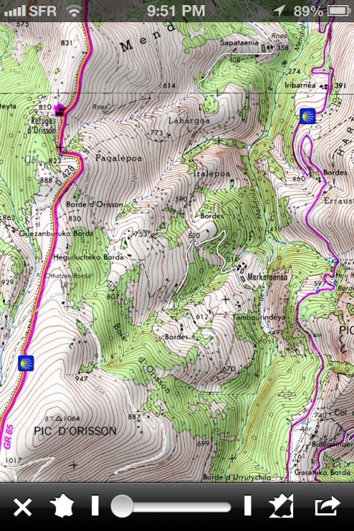
Interestingly, I noticed that the maps of Spain at some resolutions show the Camino trails marked with blue and yellow shell graphics. See:
IMG_3278.jpg
 
Interesting Doug,how do you orientate a map to the ground,without a compass,in dense bush,or desert ?.......:confused:.......Vicrev
Not being able to see far can be a limitation in the bush, but neither are completely featureless. Which desert were you planning to walk across in Spain?
 
Very light, comfortable and compressible poncho. Specially designed for protection against water for any activity.

Our Atmospheric H30 poncho offers lightness and waterproofness. Easily compressible and made with our Waterproof fabric, its heat-sealed interior seams guarantee its waterproofness. Includes carrying bag.

€60,-
A book in one hand........... a GPS in the other............ and a map on the ground(no compass).....:confused:, leaves no time for walking.;)

Buen Camino!
 
Last edited by a moderator:
Not being able to see far can be a limitation in the bush, but neither are completely featureless. Which desert were you planning to walk across in Spain?


There are no deserts in Europe but there are semi deserts. In Spain you have a few .

Monegros - Aragon

Tabernas Desert - Almeria

Bardenas Reales - Navarra ( just a stone throw from Pamplona/Iruña)

Buen Camino!
 
Dougf....Doesn't matter where the desert is ......:rolleyes:....................You are the one who said you learnt the skill of orientating a map to the ground,just curious how you do it.................what has walking across a desert in Spain got to do with it ? ........:confused:.............Vicrev
 
Down bag (90/10 duvet) of 700 fills with 180 g (6.34 ounces) of filling. Mummy-shaped structure, ideal when you are looking for lightness with great heating performance.

€149,-
Hi jmc...........Do they have fold up maps?(yes I know I need to get with technology).they seem better than the ones I buy in Argenton.......Cheers Vicrev
 
Dougf....Doesn't matter where the desert is ......:rolleyes:....................You are the one who said you learnt the skill of orientating a map to the ground,just curious how you do it.................what has walking across a desert in Spain got to do with it ? ........:confused:.............Vicrev
Sorry vicrev, I mistook the intent of your earlier question, and thought you must have had a genuine interest in the particular problem you raised because you were intending to face it at some stage on a pilgrimage. So if you aren't planning on a crossing a desert on a pilgrimage walk, what was your purpose in asking the question?
 
Hi Vicrev, yes IGN has fold up maps. They take up lots of space, aren't negligible in weight, cost a fortune, are a bitch to refold in the wind and don't automatically orient themselves to the land (you need dougfitz's skills to do that yourself). Tap the iPhone screen three times and the map orients itself. Like in the land of OZ ;)

@MendiWalker, I'm taking my iPhone only. It's 140 grams and fits in a pocket on the waist strap of my pack (and never has to leave there if I don't need it). Its charger, which also charges my headlamp, is 27 grams. Brierley is 305 grams and the Dintaman book is 403 grams. The iPhone is a GPS, which I may never need; contains every map available for France and Spain, if I'm interested in looking; has a few thousand songs if I want to hear some music (I can put it on at night and have it automatically turn off, if I'm having trouble falling asleep because of noise); it has a few dozen books on it, if for some reason I want to read; I can communicate with the outside world, or look up places to stay and their phone numbers to call ahead; it has a compass in case I follow someone with a paper map in their hands and we get lost; :) there is an app on it that shows me where the Sun is on completely overcast days or in the middle of severe weather (regardless of network access) in case I become disoriented; and my family can reach me in an emergency. It's also a camera for both stills and video, and a voice recorder if I want to make notes to myself. I can write, post blog entries... blah, blah, blah.

Yeah, it's a piece of high tech like the packs, sleeping bags, toiletries and clothing that we are all wearing. But having it will remove any concerns that I have of being lost or missing something beautiful, leaving me to enjoy my time, contemplate my life, enjoy all the new friends I will meet, and the people I will interact with, and never once have to use it. I thought about a Camino without technology, but even a rough cloth sack for clothing, walking stick, and leather shoes are technology, and people are already complaining on this forum about old men walking around in their undies, can you imagine if I actually left all technology behind and just walked barefoot in my birthday suit?

To each his own, right? :)
 
3rd Edition. More content, training & pack guides avoid common mistakes, bed bugs etc
The first edition came out in 2003 and has become the go-to-guide for many pilgrims over the years. It is shipping with a Pilgrim Passport (Credential) from the cathedral in Santiago de Compostela.
Doug......I have bushwalked since I was ten years old,back in the day when a compass was brass & weighed a ton, maps came from OZ Army Disposal stores & we used to look at them in awe because they had artillery trajectile formula on them(God I must stop rambling on! )....................Its just that I still have an inquiring mind & am interested to know how you can navigate with a map only........simple as that..........:)..........Vicrev
 
Last edited:
jmcorrigan..........I started reading your post ,it gradually turned into some sort of alien language,I really envy your skill in communicating with technology !!!:)..........Vicrev
 
  • Hi jmc........I notice your address is Dordogneshire.;)..........do you plan to walk from there ??.................Vicrev
 
A selection of Camino Jewellery
Vicrev, my dream is to walk out my door and continue walking until I reach SJdC. That would be a joy (buried somewhere in all the pain and exhaustion) for me. But at the moment, it doesn't look like a possibility. :(
 
jmc.........so sorry to read that..........I hope your situation improves & you can fulfill your dream....:):).........Vicrev
 
Did I walk past your door on the Via Vezelay (Lemovicensis)? If the moment passes, maybe it will be a possibility! Bon chemin.
 
The one from Galicia (the round) and the one from Castilla & Leon. Individually numbered and made by the same people that make the ones you see on your walk.
If you´ve walked the Camino del Norte you´ve walked passed mine.:)

Buen Camino!
 
You probably walked past mine, Its got a picture of Crocodile Dundee in the window ( I know,I know its gross but the French kids love it).......:eek:........Vicrev
 
Doug......I have bushwalked since I was ten years old,back in the day when a compass was brass & weighed a ton, maps came from OZ Army Disposal stores & we used to look at them in awe because they had artillery trajectile formula on them(God I must stop rambling on! )....................Its just that I still have an inquiring mind & am interested to know how you can navigate with a map only........simple as that..........:)..........Vicrev
I am a little worried that you seem to think you need more than a map to navigate. Unless you are using a compass to walk on a specific bearing when walking completely off track, what does the accuracy you get from using one do for you? If it is that important, get a simple GPS.

As for your earlier question:

Navigation 101 - Step One - Orient your map (for those who live in the northern hemisphere, I have given the directions for those of us with the sun in the north)
  • Technique 1. Find north - analogue watch gives sufficient accuracy. There are other methods that are more time consuming or only useful at night here. Point the top of the map to north. If you know roughly where you are, check the alignment of major features and make any small adjustments to align the map to the terrain.
  • Technique 2. Feature matching - find two prominent and identifiable features in the landscape that are at approximately 90deg from your current position. Identify these on the map, then align the map to these features.
  • Technique 3. Terrain matching - look at the terrain features in your immediate vicinity. Walk around if need be to see how far they extend. Look for these features on the map where you think you are located. Extend your search in the general direction you have been travelling until you identify where these are.
  • Technique 4. Feature ticking - more of a way of keeping track of how far you have walked. Check your proposed path for fairly readily identifiable features - stream crossings, ridgelines extending across a track, significant changes in slope, but not features that might readily change. As you pass these, tick them off and check what your next feature waypoint might be.
A compass can be used to improve the accuracy of these techniques if you can find well defined terrain features at a reasonable distance to give a good back-bearing.

It also helps if you keep track of where you are regularly.

Regards,
 
The 2024 Camino guides will be coming out little by little. Here is a collection of the ones that are out so far.
Hi Doug .......I think we have been at cross purposes here........I can do all that with my eyes closed ,walking backwards ( joke !)............When you originally said you could read a map orientated to the ground I took that literally,no sun,digital watch,terrain features etc.......I do have a GPS but as I have said in previous posts I use it as a backup to map & compass,mainly because I like to make my own decisions &be in control & not rely on something that can run out of charge or malfunction. I also like the challenge of navigating in unfamiliar terrain It gives me a buzz every time..........When I walk in Europe I sometimes dont even take a map the signage & markings are fantastic,a credit to the local communities who get involved (God I must stop rambling on! I think I said that somewhere before!)................Just a bit of silly stuff,there is a deliberate mistake in this post,no prizes for spotting it .....................:)............Vicrev
 
Vicrev, I don't recall saying anything more than one didn't need a compass to orient a map, rebutting an earlier comment that a map without a compass was useless. I don't know where all the other stuff you referred to came from. (text deleted)
 
Last edited:
Hi Vicrev, yes IGN has fold up maps. They take up lots of space, aren't negligible in weight, cost a fortune, are a bitch to refold in the wind and don't automatically orient themselves to the land (you need dougfitz's skills to do that yourself). Tap the iPhone screen three times and the map orients itself. Like in the land of OZ ;)

@MendiWalker, I'm taking my iPhone only. It's 140 grams and fits in a pocket on the waist strap of my pack (and never has to leave there if I don't need it). Its charger, which also charges my headlamp, is 27 grams. Brierley is 305 grams and the Dintaman book is 403 grams. The iPhone is a GPS, which I may never need; contains every map available for France and Spain, if I'm interested in looking; has a few thousand songs if I want to hear some music (I can put it on at night and have it automatically turn off, if I'm having trouble falling asleep because of noise); it has a few dozen books on it, if for some reason I want to read; I can communicate with the outside world, or look up places to stay and their phone numbers to call ahead; it has a compass in case I follow someone with a paper map in their hands and we get lost; :) there is an app on it that shows me where the Sun is on completely overcast days or in the middle of severe weather (regardless of network access) in case I become disoriented; and my family can reach me in an emergency. It's also a camera for both stills and video, and a voice recorder if I want to make notes to myself. I can write, post blog entries... blah, blah, blah.

Yeah, it's a piece of high tech like the packs, sleeping bags, toiletries and clothing that we are all wearing. But having it will remove any concerns that I have of being lost or missing something beautiful, leaving me to enjoy my time, contemplate my life, enjoy all the new friends I will meet, and the people I will interact with, and never once have to use it. I thought about a Camino without technology, but even a rough cloth sack for clothing, walking stick, and leather shoes are technology, and people are already complaining on this forum about old men walking around in their undies, can you imagine if I actually left all technology behind and just walked barefoot in my birthday suit?

To each his own, right? :)

Don´t forget a juicer for that iPhone . The battery doesn´t last long if you use the GPS on it.;)

Buen Camino!
 
The 9th edition the Lightfoot Guide will let you complete the journey your way.
Don´t forget a juicer for that iPhone . The battery doesn´t last long if you use the GPS on it.;)

Buen Camino!

The 'juicer' was listed. It's 27 grams and serves to also recharge my headlamp. Perhaps you didn't see that in the second line of my remarks? Anyway, I'm not going to use the GPS function, unless I get lost. You know us techies, we can't even see the ground in front of us because we are always staring at a screen of some sort. Or something like that... :/
 
Re - The map & compass discussion.

I can see both sides, having walked across the Kalahari in Botswana without needing to use my compass but a map is useless in thick fog or blizzard conditions.

For instance on Ben Nevis in Scotland the only safe way of the top in winter is to follow a very specific compass bearing.

In similar conditions in the Spanish mountains it will be the same.
 
Good God Doug ......I dont like the comment about my imagination,senility hasnt set in yet........the other was just conversation, obviously meaningless to you.......I will keep my opinions & comments to myself regarding your statements or opinions.........Vicrev
 
Ideal pocket guides for during & after your Camino. Each weighs only 1.4 oz (40g)!
Re - The map & compass discussion.

I can see both sides, having walked across the Kalahari in Botswana without needing to use my compass but a map is useless in thick fog or blizzard conditions.

For instance on Ben Nevis in Scotland the only safe way of the top in winter is to follow a very specific compass bearing.

In similar conditions in the Spanish mountains it will be the same.
Houlet, I agree, but wonder how these extremes are relevant to walking the CF or any of the other camino routes in Spain. If conditions were that bad, I think I might be seeking a nice warm (hopefully) albergue and asking to stay an extra night. I lack the imagination to see walking in such conditions as being anything but an extraordinarily risky undertaking.

Regards,
 
The 'juicer' was listed. It's 27 grams and serves to also recharge my headlamp. Perhaps you didn't see that in the second line of my remarks? Anyway, I'm not going to use the GPS function, unless I get lost. You know us techies, we can't even see the ground in front of us because we are always staring at a screen of some sort. Or something like that... :/

I meant one of these http://store.apple.com/us/product/HC927ZM/A/mophie-juice-pack-air-for-iphone-5?fnode=48

Hope to meet you one day on the Camino meanwhile...........

Buen Camino!
 
Crikey, I really do need to catch up,I thought a juicer was something you put oranges in!!!.........:(......Vicrev
 
Join our full-service guided tour of the Basque Country and let us pamper you!
Ideal pocket guides for during & after your Camino. Each weighs only 1.4 oz (40g)!

Most read last week in this forum

La Voz de Galicia has reported the death of a 65 year old pilgrim from the United States this afternoon near Castromaior. The likely cause appears to be a heart attack. The pilgrim was walking the...
This is my first posting but as I look at the Camino, I worry about 'lack of solitude' given the number of people on the trail. I am looking to do the France route....as I want to have the...
The Burguete bomberos had another busy day yesterday. Picking up two pilgrims with symptoms of hypothermia and exhaustion near the Lepoeder pass and another near the Croix de Thibault who was...
Between Villafranca Montes de Oca and San Juan de Ortega there was a great resting place with benches, totem poles andvarious wooden art. A place of good vibes. It is now completely demolished...
Left Saint Jean this morning at 7am. Got to Roncesvalles just before 1:30. Weather was clear and beautiful! I didn't pre book, and was able to get a bed. I did hear they were all full by 4pm...
Hi there - we are two 'older' women from Australia who will be walking the Camino in September and October 2025 - we are tempted by the companies that pre book accomodation and bag transfers but...

❓How to ask a question

How to post a new question on the Camino Forum.

Forum Rules

Forum Rules

Camino Updates on YouTube

Camino Conversations

Most downloaded Resources

This site is run by Ivar at

in Santiago de Compostela.
This site participates in the Amazon Affiliate program, designed to provide a means for Ivar to earn fees by linking to Amazon
Official Camino Passport (Credential) | 2024 Camino Guides
Back
Top