• For 2024 Pilgrims: €50,- donation = 1 year with no ads on the forum + 90% off any 2024 Guide. More here.
    (Discount code sent to you by Private Message after your donation)
  • ⚠️ Emergency contact in Spain - Dial 112 and AlertCops app. More on this here.

Search 69,459 Camino Questions

Overdoing it on the Salvador

peregrina2000

Moderator
Staff member
Just got a long WhatsApp from Ender with a bit of frustration at the lack of preparation on the part of some peregrinos.

This week he was in Poladura at 4:30 in the afternoon and he met two peregrinas who were resting and planning to go on to Llanos de Somerón. For anyone who has walked the Salvador, you will immediately recognize that this is NOT a viable idea for any pilgrim I can think of, not even even for @BeatriceKarjalainen. Ender called Llanos, and it was full anyway, as was Pajares. So he convinced the women to stay in Poladura and to go the next day to Bendueños. If he hadn’t been there, who knows what they would have done.

Also yesterday, he met a group of jóvenes who wanted to walk from La Robla to Llanos de Somerón. They got to Poladura at 5:30 in the afternoon completely agotados/drained/spent/exhausted. They had to get a taxi, not an easy thing to do to go from Poladura to Llanos in a taxi, which must have had to come from somewhere far away.

Incidents like this might lead the Salvador angels to wonder whether publicizing the beauty and majesty of the Salvador may have some bad unintended consequences. So, please oh please, be sensible if you walk.
 
Join our full-service guided tour and let us convert you into a Pampered Pilgrim!
could you (or someone else) give a summary of the standard stages/distances and the sensible options for varying them just to add some context to the above examples?


Sure.

But first the context — the two peregrinas were in Poladura at 4:30 pm, presumably having already walked at least 14-15 km from Pola de Gordón. That has a mountain stretch with about 500-700 m elevation gain (the numbers vary so dramatically it’s hard to be precise, but there is a substantial ascent). They were then planning to set out on another approximately 20 km with another strenuous ascent of around 600 m). That would have been “only“ a 35 km day, within the walking range of some, but starting the second remote big ascent at 4:30 pm would have been nuts.

The Salvador is about 120 km, but the spectacular mountains in the middle make it a challenge.

4 days is easy to mark out.
León to Pola de Gordón (36)
Pola de Gordón to Pajares (30)
Pajares to Pola de Lena (24)
Pola de Lena to Oviedo (31)

Really the only way to walk a four-day Salvador is to take the first day to Pola de Gordón. Then the second day, though “only” 30, has two substantial ascents. Day 3 is quite manageable, at least if it isn’t raining on the way down to Campomanes, and the last day has a lot of asphalt and 3 ascents, though thankfully they go from hardest to easiest.

I have done those stages, but that option is now firmly in my rear view mirror. If I ever get back, here is what I would do.

León - La Robla (27)
La Robla-Poladura (24)
Poladura - Bendueños (30)
Bendueños - Mieres (22.5)
Mieres - Oviedo (16)

The Poladura to Bendueños stage is still probably too much for many people, because it has a lot of up and down. It is spectacular, it is the “etapa reina” of this camino. And it is easy to break it up even more, by adding another day. Poladura to Pajares (about 14-15) and Pajares to Pola de Lena (25).

There are LOTS of ways to break this walk up into small chunks, Ender’s guide shows that clearly. There are not so many ways to break it up into 20-25 km chunks. And unless you are used to mountain walking, it is always important to remind yourself that 10 km on flat ground bears very little resemblance to 10 km out on the Salvador mountains.

If I were planning to walk this, I would first look at the mountain part — Pola de Gordón to Pajares. First decide whether you want to break those 30 km up in Poladura, which is nicely located roughly in the middle, after the first ascent/descent and before the second. There is both an albergue and a Casa Rural, which also serves meals to the albergue residents if they wish. But no other services. Then it’s just a matter of seeing how many days your have, because you can keep it at 14-15 a day or go longer depending on your walking habits.

Happy to help if anyone is trying to figure this out with shorter stages! Buen camino, Laurie
 
The 2024 Camino guides will be coming out little by little. Here is a collection of the ones that are out so far.
Laurie - I hope to stay on Enders good side....As you're aware I'll be walking this route in three weeks, and am really looking forward to it. You and others have given great advice!

I plan to walk and let my body do the talking. My plan right now is five days, with La Robla as night 1 and Poladura as night 2.

The next day I'm thinking Llanos de Someron (19k) or Bendueños (30k). I'm pretty certain the 30k is quite doable, but that's me talking from a chair in the US...

So, that leads to one complication that I'd love your thoughts on: planning for meals. It seems I will need to call ahead from Poladura to reserve a bed/meal in Llanos or Bendueños - but I won't be sure where my body will take me that day! Do you have a suggestion?

Thanks, and Happy Easter!
Bob
 
Sure.

But first the context — the two peregrinas were in Poladura at 4:30 pm, presumably having already walked at least 14-15 km from Pola de Gordón. That has a mountain stretch with about 500-700 m elevation gain (the numbers vary so dramatically it’s hard to be precise, but there is a substantial ascent). They were then planning to set out on another approximately 20 km with another strenuous ascent of around 600 m). That would have been “only“ a 35 km day, within the walking range of some, but starting the second remote big ascent at 4:30 pm would have been nuts.

The Salvador is about 120 km, but the spectacular mountains in the middle make it a challenge.

4 days is easy to mark out.
León to Pola de Gordón (36)
Pola de Gordón to Pajares (30)
Pajares to Pola de Lena (24)
Pola de Lena to Oviedo (31)

Really the only way to walk a four-day Salvador is to take the first day to Pola de Gordón. Then the second day, though “only” 30, has two substantial ascents. Day 3 is quite manageable, at least if it isn’t raining on the way down to Campomanes, and the last day has a lot of asphalt and 3 ascents, though thankfully they go from hardest to easiest.

I have done those stages, but that option is now firmly in my rear view mirror. If I ever get back, here is what I would do.

León - La Robla (27)
La Robla-Poladura (24)
Poladura - Bendueños (30)
Bendueños - Mieres (22.5)
Mieres - Oviedo (16)

The Poladura to Bendueños stage is still probably too much for many people, because it has a lot of up and down. It is spectacular, it is the “etapa reina” of this camino. And it is easy to break it up even more, by adding another day. Poladura to Pajares (about 14-15) and Pajares to Pola de Lena (25).

There are LOTS of ways to break this walk up into small chunks, Ender’s guide shows that clearly. There are not so many ways to break it up into 20-25 km chunks. And unless you are used to mountain walking, it is always important to remind yourself that 10 km on flat ground bears very little resemblance to 10 km out on the Salvador mountains.

If I were planning to walk this, I would first look at the mountain part — Pola de Gordón to Pajares. First decide whether you want to break those 30 km up in Poladura, which is nicely located roughly in the middle, after the first ascent/descent and before the second. There is both an albergue and a Casa Rural, which also serves meals to the albergue residents if they wish. But no other services. Then it’s just a matter of seeing how many days your have, because you can keep it at 14-15 a day or go longer depending on your walking habits.

Happy to help if anyone is trying to figure this out with shorter stages! Buen camino, Laurie
Having hiked the Salvador myself I have to say that I concur with everything you say here. Some great advice, well done. Hopefully people will take notice!
 
The next day I'm thinking Llanos de Someron (19k) or Bendueños (30k). I'm pretty certain the 30k is quite doable, but that's me talking from a chair in the US...
The great thing is that you can see how you feel after the glorious stage from Poladura to Puerto de Pajares (the high point). Soon after the Puerto de Pajares you have to decide whether to end your day in the town of Pajares (which would be a 14-15 km stage from Poladura) or take the arrow leading you to San Miguel. From San Miguel you continue either to Bendueños or Llanos. If that sounds confusing, it’s just that there is a split after the Pajares pass (not to be confused with the town of Pajares). People going beyond Pajares don’t have to go up to the town itself, but can continue straight to San Miguel. If you sleep in Pajares, you will go through San Miguel (at the bottom of the valley) the next morning.

I have not stayed in Llanos, but did stay in Bendueños once. It is one of those not-to-be-missed 5 star albergues. Beautiful views, beautiful accommodations, wonderful hospitalera who will cook you meals if you ask in advance. It is about a km off-route from Herías but very doable. There is a local church with some paintings of value that have been restored. I think Sandra has the keys and will let you in. It is really a special, wonderful place.

Llanos looks nice, too — it’s a new private albergue, whereas Bendueños is donativo.
 
Very light, comfortable and compressible poncho. Specially designed for protection against water for any activity.

Our Atmospheric H30 poncho offers lightness and waterproofness. Easily compressible and made with our Waterproof fabric, its heat-sealed interior seams guarantee its waterproofness. Includes carrying bag.

€60,-
Sounds great - are you suggesting I can just call ahead from Puerto de Pajares (assuming there's a cell signal)? I had assumed I needed to call ahead the day prior, but if it's sometime before noon or so on the same day, that's great! I will definitely know how I'm feeling by then.
Thanks!
 
So, that leads to one complication that I'd love your thoughts on: planning for meals. It seems I will need to call ahead from Poladura to reserve a bed/meal in Llanos or Bendueños - but I won't be sure where my body will take me that day! Do you have a suggestion?
Ender has repeatedly railed against the pilgrims who show up expecting to be served a meal without having given advance notice. :D I think your reaction to the day from La Robla to Poladura will tell you which of those two destinations makes more sense for you. And weather may play a part as well. I think calling the night ahead is good enough. That does remove some of the spontaneity, so if you want to be able to call it on the fly, just make sure to take enough food from Pola de Gordón so that you won’t go hungry that night.

EDIT: oops, I hadn’t seen your recent post. I think calling on the same day, especially out of high season, might not be enough advance notice. If there aren’t others coming, and if the hospitalero has to go buy food, it could be complicated. But one way to test this is to whats app the places when you are there and see what they say — ask them if confirming on the morning of is enough advance planning.
 
Technical backpack for day trips with backpack cover and internal compartment for the hydration bladder. Ideal daypack for excursions where we need a medium capacity backpack. The back with Air Flow System creates large air channels that will keep our back as cool as possible.

€83,-
👍. Everything that @peregrina2000 says.

We were in no doubt about the challenges of the Salvador when we walked in 2018 so we chose to walk 15 kms from Poladura to Pajares and the next day about 17 kms from Pajares to Benduenos. I think they were the shortest stages we’d ever walked on a camino but, in each case, when we arrived we were glad not to walk another step. 😎
 
After concurring with Laurie last June I did the 4 day variant:

León to Pola de Gordón (36)
Pola de Gordón to Pajares (30)
Pajares to Pola de Lena (24)
Pola de Lena to Oviedo (31)

I personally found it fine to do as that first day is terrain wise not difficult. That said, I am used to walking long distances even in rough terrain. I did book in advance, something I almost never do but that's because Spain was still in the Covid mode with few open albergues. I had really wanted to stay with Sandra in Bendueños but she was still closed.

The Salvador is lovely, I walked it pretty much alone only seeing a couple of pilgrims in a café in Puerto de Pájares. This year will surely be different.
 
The Salvador is about 120 km, but the spectacular mountains in the middle make it a challenge.
Amazing, thanks for all your info. I have a call with a friend tomorrow to see if we can arrange to walk the Salvador together in mid-June after I finish with the CPI+, so this is all super useful as I haven't really looked into it yet. I imagine we'll go for a 5-6 stage option but we'll see what time we have to play with.
 
New Original Camino Gear Designed Especially with The Modern Peregrino In Mind!
Thank you for all of this real time advice. I have set my dream sight on El Salvador even if I live nearly below sea level in Miami. Spending my spare time perusing Ender, Ellie Bieling’s ebook, El Salvador FB pages, Gronze, Buen Camino app, HERE this marvelous resource of veterans and mentors. Then off I go on my goat/lamb/sheep trail. Because I love the mountains and because I am equally terrified of them, thinking I should slow it down/ savor this one.
Whaddaya guys think of the following:
1) Leon to Cabanillas 18 km
2) Cabanillas to La Pola 20
3) La Pola to Poladura 14.3
4) Poladura to Llanos de Someron 18
5) Llanos to Bendueños 10 to enjoy this spot
6) Bendueños to Mieres 32.5 ??!!??
7. Mieres to Oviedo 17.9
Early days, playing with it all. Emptying my backpack. Early early early. Dream dream dream.
Buen Camino to all, Aymarah
 
Sure.

But first the context — the two peregrinas were in Poladura at 4:30 pm, presumably having already walked at least 14-15 km from Pola de Gordón. That has a mountain stretch with about 500-700 m elevation gain (the numbers vary so dramatically it’s hard to be precise, but there is a substantial ascent). They were then planning to set out on another approximately 20 km with another strenuous ascent of around 600 m). That would have been “only“ a 35 km day, within the walking range of some, but starting the second remote big ascent at 4:30 pm would have been nuts.

The Salvador is about 120 km, but the spectacular mountains in the middle make it a challenge.

4 days is easy to mark out.
León to Pola de Gordón (36)
Pola de Gordón to Pajares (30)
Pajares to Pola de Lena (24)
Pola de Lena to Oviedo (31)

Really the only way to walk a four-day Salvador is to take the first day to Pola de Gordón. Then the second day, though “only” 30, has two substantial ascents. Day 3 is quite manageable, at least if it isn’t raining on the way down to Campomanes, and the last day has a lot of asphalt and 3 ascents, though thankfully they go from hardest to easiest.

I have done those stages, but that option is now firmly in my rear view mirror. If I ever get back, here is what I would do.

León - La Robla (27)
La Robla-Poladura (24)
Poladura - Bendueños (30)
Bendueños - Mieres (22.5)
Mieres - Oviedo (16)

The Poladura to Bendueños stage is still probably too much for many people, because it has a lot of up and down. It is spectacular, it is the “etapa reina” of this camino. And it is easy to break it up even more, by adding another day. Poladura to Pajares (about 14-15) and Pajares to Pola de Lena (25).

There are LOTS of ways to break this walk up into small chunks, Ender’s guide shows that clearly. There are not so many ways to break it up into 20-25 km chunks. And unless you are used to mountain walking, it is always important to remind yourself that 10 km on flat ground bears very little resemblance to 10 km out on the Salvador mountains.

If I were planning to walk this, I would first look at the mountain part — Pola de Gordón to Pajares. First decide whether you want to break those 30 km up in Poladura, which is nicely located roughly in the middle, after the first ascent/descent and before the second. There is both an albergue and a Casa Rural, which also serves meals to the albergue residents if they wish. But no other services. Then it’s just a matter of seeing how many days your have, because you can keep it at 14-15 a day or go longer depending on your walking habits.

Happy to help if anyone is trying to figure this out with shorter stages! Buen camino, Laurie
Since we wanted to enjoy the exceptional scenery and some unforgettable stops, after Poladura, we stopped in Pajares. It was a good decision as it is such lovely perch. We then had the easy walk to Benduenos where we enjoyed hospitality unlike any other albergue on any other camino.

Our walk was six days. If you're not in a hurry, I would strong recommend this option.
 
Join our full-service guided tour and let us convert you into a Pampered Pilgrim!
6) Bendueños to Mieres 32.5 ??!!??
That is a day with not much elevation, just a potentially nasty rocky descent into Campomanes. Then for the rest of the time, there is a lot of walking along the side of the river on a paved path (but usually with dirt alternatives).

It is also the day in which you will pass by Santa Cristina de Lena, a pre-romanesque beauty. It is up on a hill surrounded by hills, very beautiful peaceful setting. Very much worth a visit inside. The woman who cares for the church lives nearby. In the ”old days” you could just ring her at any time and she would come up. Traffic on the Salvador has increased a LOT, so she now seems to stick to the posted hours. If you like ancient churches, this is one that absolutely cannot be missed. Leaving from Bendueños, you have an easy 6 or 7 km walk. And it doesn’t open till 11, so you would have to adjust to a later departure and maybe a second breakfast in Campomanes.

If you don’t want to add a day, which is easy to do with places to stay in Pola de Gordón, this is probably the best way to do a 7 day Salvador. It is better, IMO, to have the long day be Bendueños to Mieres than Pola de Gordón to Oviedo.
 
Not being the purists we once were, we took a morning bus from Mieres to Oviedo. Too much bitumen coming in to Mieres on the previous afternoon and not keen for more. Or maybe we missed a greener option - always a possibility.

Anyway, we were due to fly out the next morning, so instead of walking from Mieres we chose to have a lovely day in Oviedo, one of our favourite towns. 😎
 
Amazing, thanks for all your info. I have a call with a friend tomorrow to see if we can arrange to walk the Salvador together in mid-June after I finish with the CPI+, so this is all super useful as I haven't really looked into it yet. I imagine we'll go for a 5-6 stage option but we'll see what time we have to play with.
You’re the young whippersnapper in the group, so I think the five day version is fine for you. But the camino has a LOT to savor — some great albergues, incredible vistas from high points, and that preromanesque church! There are those who live in the flatlands who rarely get to savor mountains, and those folk might want to consider breaking up the days in the mountains (or combining them into one if the next day looks like rain). Poladura is the only place to break the days up and it is a sleepy little village with nothing going on but in a lovely setting.
 
New Original Camino Gear Designed Especially with The Modern Peregrino In Mind!
“It is also the day in which you will pass by Santa Cristina de Lena, a pre-romanesque beauty.”
Laurie, you just piqued my interest. What a great detour. The have a website which distinguishes between summer open at 11 and winter opening at 11:30. No specifications on when each of these begin. I love this kind of uncertainty…would love to see it. Gracias por la información!
 
The next day I'm thinking Llanos de Someron (19k) or Bendueños (30k). I'm pretty certain the 30k is quite doable, but that's me talking from a chair in the US...

The great thing is that you can see how you feel after the glorious stage from Poladura to Puerto de Pajares (
I walked the 30 km, from Poladura to Campomanes. Although it wasn't the farthest distance that I've walked in a day on the Camino it was the longest day time-wise.

I arrived at Puerto de Pajares pretty early and decided to continue on to Campomanes, based on how the walk had been so far that day, and the fact that there was rain in the forecast the next day. Since I hadn't had a response from Sandra at the albergue in Bendueños I made a reservation at a pensión in Campomanes.

There was so much up and an down that it was pretty slow going in the afternoon, and I finally arrived, exhausted, in Campmanes at 5:00. Fortunately, my pensión room was very comfortable, and the clothes washing was included in the price.

I am glad that I didn't walk that section in the rain, but if I were to do it again, and there were no issues with the weather I would split that section up.
 
You’re the young whippersnapper in the group
We were just calling some early 20s hikers 'young whippersnappers' on the Rota Vicentina last week! Everybody's whippersnappers are relative, I guess. 🤣

But in my 'Jackie Robinson year', I'll take young!
 
The 2024 Camino guides will be coming out little by little. Here is a collection of the ones that are out so far.
León - La Robla (27)
La Robla-Poladura (24)
Poladura - Bendueños (30)
Bendueños - Mieres (22.5)
Mieres - Oviedo (16)

The Poladura to Bendueños stage is still probably too much for many people, because it has a lot of up and down. It is spectacular, it is the “etapa reina” of this camino. And it is easy to break it up even more, by adding another day. Poladura to Pajares (about 14-15) and Pajares to Pola de Lena (25).
Then you'd miss Bendueños, but could still do it in 5 days with day 5 being Pola de Lena to Oviedo (31.4km). And Santa Cristina de Lena (a must for me) would come late in the day if starting in Pajares rather than early if starting in Bendueños. Alternatively, break up the long stage directly into two as @anamcara did (Poladura - Pajares and Pajares - Bendueñoes) and do it in six stages, with the rest as above.
 
Then you'd miss Bendueños, but could still do it in 5 days with day 5 being Pola de Lena to Oviedo (31.4km).
It is better, IMO, to have the long day be Bendueños to Mieres than Pola de Gordón to Oviedo.

I missed this comment before writing the sentence above.

But just to confirm distances:
Bendueños - Mieres (22.5)
6) Bendueños to Mieres 32.5 ??!!??

I did some quick math(s) on Gronze and it seems 22.5km is right. So it's not such a long day after all?
 
I missed this comment before writing the sentence above.

But just to confirm distances:


I did some quick math(s) on Gronze and it seems 22.5km is right. So it's not such a long day after all?
I have been following all the above. Pay special attention to what @peregrina2000 says! Distance on the Salvador is not anything like distance on the flat.
@jungleboy, it seems to me that you and Wendy will manage just fine. Just be aware! Enjoy.
 
3rd Edition. More content, training & pack guides avoid common mistakes, bed bugs etc
I have been following all the above. Pay special attention to what @peregrina2000 says! Distance on the Salvador is not anything like distance on the flat.
@jungleboy, it seems to me that you and Wendy will manage just fine. Just be aware! Enjoy.
Not suggesting otherwise, just confirming that it’s 22.5km, not 32.5km!
 
I remain somewhat intimidated by this route, but I'm sure it will all work out. If you want to see a group manage it seemingly with no problem (think dancing, jogging, playing in the snow!) then watch the YouTube videos of Alvaro Lazaga Busto's group Camino 48 that were posted last week.
 
St James' Way - Self-guided 4-7 day Walking Packages, Reading to Southampton, 110 kms
Sorry that I didn’t check the distances before reacting to the 32.5 figure. My comment is still the same, though, which is that I think the Pola de Gordón to Oviedo day is much more tiring than Bendueños to Mieres. And now I know it is also 10 km longer!

Back to a few @jungleboy specifics — Santa Cristina is beautiful in any time of day, since it is sitting alone on a hilltop you will always be able to photograph it in good light (assuming it’s not raining). You will get there early from Bendueños, but that will just give you more time to sit there and contemplate. And there is a café just as you leave Campomanes, right before getting on the river walk, where you can have a big breakfast. But Bendueños is only about 5 or 6 km from the church so it cries out for a late morning start.

The parish church in Bendueños is also well worth a visit. There has been some restoration done, thanks to one of Ender’s friends, which I describe in this post.

After Pola de Gordón a new alternative is marked that avoids the awful highway stretch into Ujo. It is really one of those truck-laden, no-shoulder roads that instills terror if you are walking it when there is traffic. Álvaro Lazaga recently walked it and described the alternative as tough, but I will have to go back to his videos and pay more careful attention. Check Ender’s new guide for pictures and more details.

And while we are at it, I will also encourage anyone walking this route to pay careful attention to Ender’s description of the “Munisteriu” alternative after Llanos de Somerón. It was a killer for me this past September. But quite beautiful. I think they may have done some work on it, but it would be a good idea to check with the hospitalero in Llanos who is the one who knows the most about it. Sandra may not have much knowledge in Bendueños. There are actually three alternatives in the stretch after Llanos, and you should make sure you know which one you are getting on. Luckily, we have our own forum guinea pig @BobY333 who can report back before the whippersnapper brigade heads out.
Guinea pig indeed - and definitely not a whippersnapper!

It does feel like there are a bunch of alternatives in Ender's guide. I'll try to keep the group posted on which specific route(s) I take. I'll make a note to check in with the hospitalero in Llanos about the condition of the "Munisteriu". I just hope to keep a smile on my face and enjoy whatever comes!
 
Really a rule of thumb but:

Naismith's Rule, allows an easy calculation of the time taken for a hill walk, for a reasonably fit and steady walker: 15 minutes for every kilometre of horizontal distance, plus 10 minutes for every 100 metres of ascent. The time should be calculated for the slowest person in a walking group.
 
New Original Camino Gear Designed Especially with The Modern Peregrino In Mind!
BTW & FYI, sometimes guides may give an equivalent distance to account for climbs. Brieley does using a variant of the example I'm going to give.

Assume you walk a track on Wikiloc that says it is 20 km with an *accumulative* climb of 600 m. At 15 minutes per km (4 km/hr) your walk time is 5 hours if the track were level but at 10 minutes per 100 m you are slowed down by an additional hour. On the level that additional hour walking would allow you to go 4 km. So you may see an equivalent distance of 24 km given.

The equivalent distance is handy when you are faster or slower than the 4 km/hr that Naismith expects. If you walk at 3 km/hr you might expect your 20 km walk (with a 24 km equivalent) to take about 8 hours and at 5 km/hr a bit under 5 hours.
 
Last edited:
BTW & FYI, sometimes guides may give an equivalent distance to account for climbs. Brieley does using a variant of the example I'm going to give.

Assume you walk a track on Wikiloc that says it is 20 km with an *accumulative* climb of 600 m. At 15 minutes per km (4 km/hr) your walk time is 5 hours if the track were level but at 10 minutes per 100 m you are slowed down by an additional hour. On the level that additional hour walking would allow you to go 4 km. So you may see an equivalent distance of 24 km given.
Thanks for figuring it out in metrics my brain can follow.
And a loud MEA CULPA, for previously putting in the wrong kms.
 
Back to a few @jungleboy specifics — Santa Cristina is beautiful in any time of day, since it is sitting alone on a hilltop you will always be able to photograph it in good light (assuming it’s not raining). You will get there early from Bendueños, but that will just give you more time to sit there and contemplate.
I was thinking more about what time it closes for the day, but in the end I think we're going to opt for a stage plan that results in the early option anyway.

Thanks as always for all the other very helpful tips too. I spoke with my friend today and it looks like it's on, starting around June 15! I have Ender's guide now so there's no going back! 🤣
 
St James' Way - Self-guided 4-7 day Walking Packages, Reading to Southampton, 110 kms
I have taken 6 days to walk it on two occasions. La Robla ,Poladura, Pajares, Pola de Lena , Mieres Oviedo. No long stretches.
That’s a great 6 day option. It’s a tough choice betwen Pajares and Bendueños, and the Pajares albergue has not yet opened, not because of covid but because of the health of the hospitalera Marisa. The Salvador community very much hopes she will soon be able to return to the albergue, where she is a much-loved hospitalera. In the meantime, both the Bar Mirador and a casa rural offer accommodation.
 
That’s a great 6 day option. It’s a tough choice betwen Pajares and Bendueños, and the Pajares albergue has not yet opened, not because of covid but because of the health of the hospitalera Marisa. The Salvador community very much hopes she will soon be able to return to the albergue, where she is a much-loved hospitalera. In the meantime, both the Bar Mirador and a casa rural offer accommodation.
I hope Marisa gets well soon . Back in 2016 she cooked us hearty meals . Great hospitalera.
 
The 2024 Camino guides will be coming out little by little. Here is a collection of the ones that are out so far.
I hope Marisa gets well soon . Back in 2016 she cooked us hearty meals . Great hospitalera.
I share those sentiments. You realize how personality-driven these great albergues are. I don’t know if there is anyone else to step into her shoes should that be necessary. It’s a good thing that there are private options in Pajares, but she adds something to the experiences that the other places can’t hold a candle to. I remember when I was last there, she was organizing a big bed transfer — Pola de Gordón had too many, Pajares had too few, and she was like the field marshall taking care of business always with kindness and a smile.
 
Thank you for all of this real time advice. I have set my dream sight on El Salvador even if I live nearly below sea level in Miami. Spending my spare time perusing Ender, Ellie Bieling’s ebook, El Salvador FB pages, Gronze, Buen Camino app, HERE this marvelous resource of veterans and mentors. Then off I go on my goat/lamb/sheep trail. Because I love the mountains and because I am equally terrified of them, thinking I should slow it down/ savor this one.
Whaddaya guys think of the following:
1) Leon to Cabanillas 18 km
2) Cabanillas to La Pola 20
3) La Pola to Poladura 14.3
4) Poladura to Llanos de Someron 18
5) Llanos to Bendueños 10 to enjoy this spot
6) Bendueños to Mieres 32.5 ??!!??
7. Mieres to Oviedo 17.9
Early days, playing with it all. Emptying my backpack. Early early early. Dream dream dream.
Buen Camino to all, Aymarah
Having over committed on my first attempt at this Camino, this sounds very realistic and a great plan. Good luck.
 
Really a rule of thumb but:

Naismith's Rule, allows an easy calculation of the time taken for a hill walk, for a reasonably fit and steady walker: 15 minutes for every kilometre of horizontal distance, plus 10 minutes for every 100 metres of ascent. The time should be calculated for the slowest person in a walking group.
This is a good rule of thumb and I wish I had seen it before my Camino de Salvador. Such a beautiful route, which I could have enjoyed if I had gone less KM’s. Folks be smart, do your homework, this is not the CF. Enjoy!
 
Ideal sleeping bag liner whether we want to add a thermal plus to our bag, or if we want to use it alone to sleep in shelters or hostels. Thanks to its mummy shape, it adapts perfectly to our body.

€46,-
This is a good rule of thumb and I wish I had seen it before my Camino de Salvador.
There are other rules of thumb that do things like slow you down some after reaching certain distances because you will be tired or add time for really steep downhills. The Wikipedia page for Naismith's rule goes into this a bit. But for an easy approximation I haven't seen anything simpler than Naismith's rule. Remember though the uphill elevation changes include all the little ups that follow the downs. This makes the Camino Francés' Valcarlos route almost as tough elevation-wise as the Napoleon Route.
 
There are other rules of thumb that do things like slow you down some after reaching certain distances because you will be tired or add time for really steep downhills. The Wikipedia page for Naismith's rule goes into this a bit. But for an easy approximation I haven't seen anything simpler than Naismith's rule. Remember though the uphill elevation changes include all the little ups that follow the downs. This makes the Camino Francés' Valcarlos route almost as tough elevation-wise as the Napoleon Route.
I often wonder about elevation status. So if I understand what you’re saying - I start at sea level and go up to a 1000m pass the books will say “1000m gain”. However If there were many many 10m tiny hills in between then these aren’t included? I’ve always felt the low Roncesvalles route is as tough as the high route because of the small ups and downs which don’t figure into the calculations.
 
The San Salvador is spectacular in many ways. It is hard, and for someone my age I take it in six-seven stages. I've completed it twice and will go again, even though it's 120 km it provides something special, the most intense 120 km of any Camino, for me. Its the only route where I have seen snakes (close-up, on the path) - two different type, every time I've been on the San Salvador, so be careful when you tramp into the undergrowth to relieve yourself. Its the only route where I've seen evidence of wild boar on the path and their same-day activity. I've been told of the small wolf pack, diminished because the farmers shoot the Alpha males so that the pack won't thrive. I find the farmer's dogs very threatening - you must do your best not to react to them and ignore them, despite how close they may get. The farmers need their dogs viscous and threatening because of the wolves, I suppose, but they should teach them that pilgrims are not a threat to their sheep - even hungry pilgrims.
The people are only too pleased to welcome you and be of assistance, have a chat, and the route volunteers do magnificent work. Don't forget to collect your special Credencial del Peregrino specifically for the San Salvador, and your certificate from the Cathedral in Oviedo.
Buen Camino.
 
The 2024 Camino guides will be coming out little by little. Here is a collection of the ones that are out so far.
“ Its the only route where I have seen snakes (close-up, on the path) - two different type, every time I've been on the San Salvador,”
YIKES!!!! I can deal with wolves, dogs, and wild boar but snakes 😱😳!!! @RalphKeith any more information on the snakes?
 
Technical backpack for day trips with backpack cover and internal compartment for the hydration bladder. Ideal daypack for excursions where we need a medium capacity backpack. The back with Air Flow System creates large air channels that will keep our back as cool as possible.

€83,-
Thank you! Is that albergue recommended?
Depends on what you are thinking in terms of covid. It’s a big albergue, the León albergue “de siempre,” I assume they are back to full capacity, and it was a bit crowded. 4 rooms with 134 beds. The albergue will move to another location, but I can’t imagine it will happen before your walk. I saw the building permits for the new albergue tacked to a wall on the street for the new one, but I can’t remember where it was exactly, and I don’t have any specific information. But it’s in the same vicinity as the current Carbajalas.

I have stayed in this albergue several times, but the last couple of times I was through León I opted for private accommodations. There are just so many choices in León! I was surprised to see how many private albergues there are, and a huge supply of hotels and pensiones.

Unrelated historical tidbit: I learned when I was translating Ender’s Salvador guide that the name “Carbajalas” comes from the fact that it was originally located in Carbajal, which is the first town outside of León on the Salvador. When the Salvador lost out in popularity to the Francés, they moved the Carbajal albergue to León.
 
St James' Way - Self-guided 4-7 day Walking Packages, Reading to Southampton, 110 kms
I’ve always felt the low Roncesvalles route is as tough as the high route because of the small ups and downs which don’t figure into the calculations.
The two routes have about the same cumlative elevation gain even though the Valcarlos peaks at lower elevation. Click the pic for details.
 
The focus is on reducing the risk of failure through being well prepared. 2nd ed.
I could look up stages but to get perspective from those who have actually walked it, could you (or someone else) give a summary of the standard stages/distances and the sensible options for varying them just to add some context to the above examples?
I have walked this route twice. Once in the Spring with snow. Once in the Fall without. The most challenging part of this route is from Buiza to Pajares. My recommended stops would be:

La Robla - All facilities - 27km's
Poladura - Albergue or Pension only food is at Pension - 24km's
Benduenos - Albergue - 31km's
Mieres - All facilities - 22km's
Oviedo - All facilities - 18km's

You could do shorter days

Cabanillas - Nice Albergue, no facilities bring your own food - 17km's
Buiza - Nice Albergue, no facilities bring your own food, if open - 24km's
Poladura - Albergue or Pension, only food at Pension - 9km's
Pajares - All facilities, if open - 14km's
Benduenos - Albergue donativo - 17km's
Mieres - All facilities - 22km's
Oviedo - All facilities - 18km's

Weather can make this route more challenging. This is a nice Camino and terrific if done in conjunction with the Primitivo.
 
Join our full-service guided tour of the Basque Country and let us pamper you!
Continuing on with calculating whether you may be overdoing things.

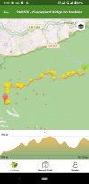
As an example of Naismith's rule I found (randomly) a GPS track that was recorded and uploaded to Wikiloc.com. It occurred in Smokey Mountain National Park (in the Appalachian Mountains of the US) starting at the green pin at an elevation of 510 meters and heading west for 18.15 kilometers ending at the red pin at an elevation of 790 meters.

Looking at the elevation profile notice that the trip started at the lowest point but did not end at the high point and there were a lot of ups and downs along the way.

(The yellow flags are waypoints that perhaps mark where pictures were taken.)

Screenshot_20220424-073322-01.jpeg

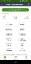
Here are some of the statistics Wikiloc gleaned from the track.

Screenshot_20220424-073409-01.jpeg

Let's use that information to get an approximate time to walk that trail. Here's the rule:
Naismith's Rule, allows an easy calculation of the time taken for a hill walk, for a reasonably fit and steady walker: 15 minutes for every kilometre of horizontal distance, plus 10 minutes for every 100 metres of ascent.

First lets compute the horizontal distance component of the total time.

18.15 km x 15 minutes / km = 272 minutes

Next the vertical component:

953 m / 100 m / vertical segment = 9.53 vertical segments
9.53 segments x 10 minutes / segment = 95 minutes

Total time:
272 minutes + 95 minutes = 367 minutes
367 minutes / 60 minutes / hour = 6.1 hours
6 hours, 6 minutes

Compare with the actual recorded time of 5 hours, 57 minutes.

Note that Wikiloc computes computes average speed by dividing the horizontal distance by the moving time so that gives you your average speed when you are actually walking. It doesn't count lunch and rest stops, time to get gravel out of your shoes or even very short pauses to take a picture or admire views. In this example the average speed of 4.1 km / hr was computed by dividing 18.15 km by 4.4 hours.
 
Continuing on with calculating whether you may be overdoing things.

As an example of Naismith's rule I found (randomly) a GPS track that was recorded and uploaded to Wikiloc.com. It occurred in Smokey Mountain National Park (in the Appalachian Mountains of the US) starting at the green pin at an elevation of 510 meters and heading west for 18.15 kilometers ending at the red pin at an elevation of 790 meters.

Looking at the elevation profile notice that the trip started at the lowest point but did not end at the high point and there were a lot of ups and downs along the way.

(The yellow flags are waypoints that perhaps mark where pictures were taken.)

View attachment 123645

Here are some of the statistics Wikiloc gleaned from the track.

View attachment 123646

Let's use that information to get an approximate time to walk that trail. Here's the rule:


First lets compute the horizontal distance component of the total time.

18.15 km x 15 minutes / km = 272 minutes

Next the vertical component:

953 m / 100 m / vertical segment = 9.53 vertical segments
9.53 segments x 10 minutes / segment = 95 minutes

Total time:
272 minutes + 95 minutes = 367 minutes
367 minutes / 60 minutes / hour = 6.1 hours
6 hours, 6 minutes

Compare with the actual recorded time of 5 hours, 57 minutes.

Note that Wikiloc computes computes average speed by dividing the horizontal distance by the moving time so that gives you your average speed when you are actually walking. It doesn't count lunch and rest stops, time to get gravel out of your shoes or even very short pauses to take a picture or admire views. In this example the average speed of 4.1 km / hr was computed by dividing 18.15 km by 4.4 hours.
Very interesting…have seen references to Naismith’s rule before and don’t profess to be an expert however the rule also estimates extra time for descents…roughly 1/2 of what it estimates for ascents.

In your Wikiloc example

It would take 4 hrs 32 minutes with no ascent/descent at 4kms per hour

Naismith estimates 6 hrs 6 minutes with 953m ascent and 0m descent

Naismith estimates 6 hrs 41 minutes with 953m ascent and 673m descent or 47% more time than walking on flat terrain. Pretty significant!

Here is a website that has an easy calculator to use…if you go with 5km an hour the increased time is 59% more than flat terrain!


Now walking from Poladura to Benduenos as per jpflavin1’s route above (something I am considering)

Using 4.5km per hour over a flat 31 km route takes 6 hours 53 minutes walking time.

Ascent 1,106m and descent 1,768m (believe from Buen Camino app) would take based on Naismith’s rule 10 hours 12 minutes walking time or 48% increase.

For those who have walked this stage does this seem like a reasonable estimate? Past experience…it’s doable but very tough!

Guy
 
I am sure there are snakes, but I have never seen one on three Salvador Caminos. You can be sure they are not hiding behind a rock waiting to slither out and scare you. 🐍🐍🐍
I am greatly relieved however now wondering bears 🐻 polar & grizzly main concerns and geez tigers 🐅 well any kind is a problem. I am going to assume ok on both fronts 😂
 
A guide to speaking Spanish on the Camino - enrich your pilgrim experience.
Very interesting…have seen references to Naismith’s rule before and don’t profess to be an expert however the rule also estimates extra time for descents…roughly 1/2 of what it estimates for ascents.
Guy, I hope you will allow me to speak from memory on this; I'm not in a situation to easily get references. I think you used one of the variants I mentioned in my post #40 above. Truth be told, the Naismith's rule I've posted is a variant also as he used English measures of distance.

To the best of my recollection Naismith did not use declines in his original calculations. Others have adjusted his formula to account for this but the most accurate would decrease the amount of time for easy to walk trails with gentle declines and increase the amount for tough steep trails. I think the author of the web page you linked us to made a mistake by increasing walking time on all down slopes instead of just steep ones. I don't see how walking down a 5% slope would increase my walking time over walking on the level.

As I wrote earlier, without mentioning to use Naismith's orginal formula, it is the easiest to use. However there might be calculators online that could take a GPS track with elevation data, walking speed over the level, fitness level and such and crunch the numbers to come up a figure.
 
Rick,

You are absolutely correct...I stand corrected. As per Wikipedia everyone has been trying to "improve" on Naismith's formula since it was first established in 1892...Scarf's, Tranters, Aiken and Langmuir (which attempts to adjust for descent based on slope as you suggest).

So I am left with a question...walking from Poladura to Benduenos...31 km Ascent 1,106m and Descent 1,768m assuming decent level of fitness, good walking conditions, feeling strong on that day...no surprise snakes what kind of walking time is reasonable to expect +/- an hour or so. Anything I have done in the past indicates a pretty tough day.
 
So I am left with a question...walking from Poladura to Benduenos...31 km Ascent 1,106m and Descent 1,768m assuming decent level of fitness, good walking conditions, feeling strong on that day...no surprise snakes what kind of walking time is reasonable to expect +/- an hour or so. Anything I have done in the past indicates a pretty tough day.
15 x 31 = 465
10 x 1,100 / 100 = 110
465 + 110 = 575
575 / 60 = 9.58
9 hours, 35 minutes

Slower if the snake is in front of you, faster if the snake is behind you.

BTW, I've been going on here endlessly on Naismith's rule because I've bookmarked the thread to come back to with the aim of editing my posts into a forum resource.
 
Join our full-service guided tour and let us convert you into a Pampered Pilgrim!
So I am left with a question...walking from Poladura to Benduenos...31 km Ascent 1,106m and Descent 1,768m assuming decent level of fitness, good walking conditions, feeling strong on that day...no surprise snakes what kind of walking time is reasonable to expect +/- an hour or so. Anything I have done in the past indicates a pretty tough day.
Bad news Guy. Overnight I came to realize that the 9.6 hours estimate that I gave you in my post #60 above was too low. That is what Naismith's rule gives but the walk is so long you are going to get tired and slow down. There is a way to estimate the additional (or shorter) time the walk will take due to fitness level and fatigue. This is Tranter's corrections. It is a table that can be seen on the webpage you sent us to but I suggest looking at it at the Naismith's rule Wikipedia page. From the table it looks like a fitness level of 25 is a close match to the level that Naismith envisioned. Using the table for that level and interpolating between the Naismith values of 9 and 10 hours you can see that Tranter would expect the walk to take about 12.5 hours.

BTW, the fitness level is the number of minutes it takes for a person to walk a half mile while simultaneously ascending a thousand feet. That's a pretty steep slope of about 40%.

In metric units that would be rise of nearly 300 meters in a run of nearly 800 meters.
 
Last edited:
Bad news Guy. Overnight I came to realize that the 9.6 hours estimate that I gave you in my post #60 above was too low. That is what Naismith's rule gives but the walk is so long you are going to get tired and slow down. There is a way to estimate the additional (or shorter) time the walk will take due to fitness level and fatigue. This is Tranter's corrections. It is a table that can be seen on the webpage you sent us to but I suggest looking at it at the Naismith's rule Wikipedia page. From the table it looks like a fitness level of 25 is a close match to the level that Naismith envisioned. Using the table for that level and interpolating between the Naismith values of 9 and 10 hours you can see that Tranter would expect the walk to take about 12.5 hours.

BTW, the fitness level is the number of minutes it takes for a person to walk a half mile while simultaneously ascending a thousand feet. That's a pretty steep slope of about 40%.

In metric units that would be rise of nearly 300 meters in a run of nearly 800 meters.
😂🤣 Considering I just turned 65 and my marathon running days are decades ago…I could be walking through the night 😂. Maybe that wouldn’t be so bad as I wouldn’t see the snakes.

Just found out that my pilgrim friend from Brazil is a go however his schedule requires Camino Primitivo only so…I must now think through whether an unorthodox Camino Primitivo followed by Camino Salvador makes sense.

In the end simply walking any Camino in 2022 would be fantastic!

Guy
 
A selection of Camino Jewellery
Bad news Guy. Overnight I came to realize that the 9.6 hours estimate that I gave you in my post #60 above was too low. That is what Naismith's rule gives but the walk is so long you are going to get tired and slow down. There is a way to estimate the additional (or shorter) time the walk will take due to fitness level and fatigue. This is Tranter's corrections. It is a table that can be seen on the webpage you sent us to but I suggest looking at it at the Naismith's rule Wikipedia page. From the table it looks like a fitness level of 25 is a close match to the level that Naismith envisioned. Using the table for that level and interpolating between the Naismith values of 9 and 10 hours you can see that Tranter would expect the walk to take about 12.5 hours.

BTW, the fitness level is the number of minutes it takes for a person to walk a half mile while simultaneously ascending a thousand feet. That's a pretty steep slope of about 40%.

In metric units that would be rise of nearly 300 meters in a run of nearly 800 meters.
Interesting discussion. Presumably when assessing yourself for Naismith's or any of these calcs one should be walking with your regular Camino load backpack?

What about the Santiago co-efficient which dictates that "one's speed increases by 10% when anticipating a latte / bakery ahead but decreases by 15% in the afternoon when inadequately fed".
 
👍. Everything that @peregrina2000 says.

We were in no doubt about the challenges of the Salvador when we walked in 2018 so we chose to walk 15 kms from Poladura to Pajares and the next day about 17 kms from Pajares to Benduenos. I think they were the shortest stages we’d ever walked on a camino but, in each case, when we arrived we were glad not to walk another step. 😎
I agree, when we walked in 2018, we broke up the stops as said before mountain walking is not like flat terrain walking! There is no reason to beat yourself up if you don't walk 30 km each day, the purpose is not to speed to the end of your walk, take in the surroundings and get to the end eventually.
 
A selection of Camino Jewellery
Just got a long WhatsApp from Ender with a bit of frustration at the lack of preparation on the part of some peregrinos.

This week he was in Poladura at 4:30 in the afternoon and he met two peregrinas who were resting and planning to go on to Llanos de Somerón. For anyone who has walked the Salvador, you will immediately recognize that this is NOT a viable idea for any pilgrim I can think of, not even even for @BeatriceKarjalainen. Ender called Llanos, and it was full anyway, as was Pajares. So he convinced the women to stay in Poladura and to go the next day to Bendueños. If he hadn’t been there, who knows what they would have done.

Also yesterday, he met a group of jóvenes who wanted to walk from La Robla to Llanos de Somerón. They got to Poladura at 5:30 in the afternoon completely agotados/drained/spent/exhausted. They had to get a taxi, not an easy thing to do to go from Poladura to Llanos in a taxi, which must have had to come from somewhere far away.

Incidents like this might lead the Salvador angels to wonder whether publicizing the beauty and majesty of the Salvador may have some bad unintended consequences. So, please oh please, be sensible if you walk.
I do so understand as I did the San Salvador last fall. I made my stages as short as possible and stayed in an apartment in Pajares. We also had taxis take our backpacks. It was well worth it and made the Camno enjoyable although we did get lost a couple of times and ran into a herd of cattle and a bull!!! We met Ender at El Embrujo albergue which is great.
 
Seems all way too complicated. I walked Poladura to Pola de Lena (about 41 kms) in Oct 2019 and it took me slightly less than 9 hours.
 
Ideal pocket guides for during & after your Camino. Each weighs only 1.4 oz (40g)!
Wow, that's fast, Mike.
I like walking and my comfortable pace is steadily decreasing with age. It's gone down to about 4, probably much slower in the mountains.
I will be interested to see what feels right when I next get to walk a camino which will probably not be until next year when I will be 69…….
 
St James' Way - Self-guided 4-7 day Walking Packages, Reading to Southampton, 110 kms
Hi all,
Thanks for sharing all the experiences. I am going to walk San Salvador in end June 2022 - I am walking with a pilgrim I met on Primitivo in 2019 - and yes, we go for 4 days which actually matches the stages earlier mentioned.
We have booked all accommodation to avoid stress and are aware of the challenges of the route.

And now I just can’t wait to go 😍
 
Bad news Guy. Overnight I came to realize that the 9.6 hours estimate that I gave you in my post #60 above was too low. That is what Naismith's rule gives but the walk is so long you are going to get tired and slow down. There is a way to estimate the additional (or shorter) time the walk will take due to fitness level and fatigue. This is Tranter's corrections. It is a table that can be seen on the webpage you sent us to but I suggest looking at it at the Naismith's rule Wikipedia page. From the table it looks like a fitness level of 25 is a close match to the level that Naismith envisioned. Using the table for that level and interpolating between the Naismith values of 9 and 10 hours you can see that Tranter would expect the walk to take about 12.5 hours.

BTW, the fitness level is the number of minutes it takes for a person to walk a half mile while simultaneously ascending a thousand feet. That's a pretty steep slope of about 40%.

In metric units that would be rise of nearly 300 meters in a run of nearly 800 meters.
Oh my dear goodness! I never signed up for this! All I wanted was to know how hard the next hill would be! 😇
 
Get a spanish phone number with Airalo. eSim, so no physical SIM card. Easy to use app to add more funds if needed.
Hehehe… I am really excited to walk San Salvador for the first time… And will bring poles for the first time on a camino…

I believe it’s not only a physical challenge, but very much a mental one! I love walking in mountains, maybe because we don’t have any where I live 😂

And I believe I am prepared for the worst - and do prepare physically… 51 days to go…
 
A selection of Camino Jewellery
Hehehe… I am really excited to walk San Salvador for the first time… And will bring poles for the first time on a camino…

I believe it’s not only a physical challenge, but very much a mental one! I love walking in mountains, maybe because we don’t have any where I live 😂

And I believe I am prepared for the worst - and do prepare physically… 51 days to go…
How exciting for you! How are you training for the mountains? 🚶🏻‍♀️🚶🏻‍♀️
 
How exciting for you! How are you training for the mountains? 🚶🏻‍♀️🚶🏻‍♀️
I do stairs… up and down… up and down… and… 😂 🤪
and also yoga and Pilates, and just hiking of course…

After San Salvador I am going to walk Primitivo…

The caminos will also be my training for a 100 km march from Wuppertal with a total of 2200 altimeters to be done in 24 hours 🤪
 
Last edited:
Join our full-service guided tour of the Basque Country and let us pamper you!
I am on the San Salvador now and it’s very hot. Day 2 today and the uphill from Buiza was brutal. Started early in La Robla, but the tough climb started around noon when it was the hottest. Bring lots of water if it’s sunny. I also bought Aquarius, the energy drink, and it saved my day.

The private hostal in Poladura is closed today, Monday, and the albergue is full, only one bed left right now at 5 pm. The restaurant is also closed on Mondays so you have to buy food for dinner (and breakfast) in Pola de Gordon.
Two pilgrims didn’t know this and they now have to take a taxi back to the supermarket..
Good for the rest of us though since they are bringing back drinks and more water for us

BUT: it was absolutely GORGEOUS out there! Amazing amazing views
Thanks for the update and information. I will take notes. Buen camino :)
 
The one from Galicia (the round) and the one from Castilla & Leon. Individually numbered and made by the same people that make the ones you see on your walk.
Gracias 😊
Pajares is also still closed so everybody is going to llanos de someron tomorrow
Thanks, I already booked for all days, as my travel companion prefers to sleep in a double room, as she can’t sleep in a dormitory - and to be honest it is my first camino with pre bookings, but I am still excited.
 
I am on the San Salvador now and it’s very hot. Day 2 today and the uphill from Buiza was brutal. Started early in La Robla, but the tough climb started around noon when it was the hottest. Bring lots of water if it’s sunny. I also bought Aquarius, the energy drink, and it saved my day.

The private hostal in Poladura is closed today, Monday, and the albergue is full, only one bed left right now at 5 pm. The restaurant is also closed on Mondays so you have to buy food for dinner (and breakfast) in Pola de Gordon.
Two pilgrims didn’t know this and they now have to take a taxi back to the supermarket..
Good for the rest of us though since they are bringing back drinks and more water for us

BUT: it was absolutely GORGEOUS out there! Amazing amazing views
Thanks for this! I arrived in León today and will walk to La Robla tomorrow. I have a 2L water bladder and an empty plastic bottle that’s easy to fill. You made my decision to get up and out early tomorrow an easier one.

I wonder if you’re in a “bubble” with many people? You have me thinking about my “wing it after La Robla” plan…

Can’t wait to get out there and experience it all!
 
St James' Way - Self-guided 4-7 day Walking Packages, Reading to Southampton, 110 kms
Thanks for this! I arrived in León today and will walk to La Robla tomorrow. I have a 2L water bladder and an empty plastic bottle that’s easy to fill. You made my decision to get up and out early tomorrow an easier one.

I wonder if you’re in a “bubble” with many people? You have me thinking about my “wing it after La Robla” plan…

Can’t wait to get out there and experience it all!
We have formed a really nice group (“camily”) this 2nd day. If you hurry you can join us ha ha
Just kidding, don’t hurry 😊 There are more pilgrims than I thought, but no bed race. 11 pilgrims here
 
We have formed a really nice group (“camily”) this 2nd day. If you hurry you can join us ha ha
Just kidding, don’t hurry 😊 There are more pilgrims than I thought, but no bed race. 11 pilgrims here
Ahhhh - that’s the best answer you could have. Looking forward to Camino camaraderie and not having to worry about a bed!
 
The one from Galicia (the round) and the one from Castilla & Leon. Individually numbered and made by the same people that make the ones you see on your walk.

Attachments

  • 1-San-Salvador-Credential.jpg
    1-San-Salvador-Credential.jpg
    242.6 KB · Views: 3
Get a spanish phone number with Airalo. eSim, so no physical SIM card. Easy to use app to add more funds if needed.
“ Its the only route where I have seen snakes (close-up, on the path) - two different type, every time I've been on the San Salvador,”
YIKES!!!! I can deal with wolves, dogs, and wild boar but snakes 😱😳!!! @RalphKeith any more information on the snakes?
Hi there - well, my last experience was close-up, too close (2019)! My friend was walking in front of me and screamed, she had to leap over the snake that was sliding out of the undergrowth. It raised its head at me, just behind her. We stepped back and it slid back to where it came for. It was the venomous 'Adder' type. I've also crossed-paths with the black viper type - you don't want a bite from that one. Just be aware.
I think its a bit unusual for me to see snakes every time I'm on the San Salvador, but I don't usually have people with me so I'm quiet, and pay attention to the paths as I have walking difficulties.
I've also seen a Megarian banded centipede. They have a nasty sting but its not so bad as a snake, so I'm told. They are beautiful but aggressive and will attack if threatened. I saw this on the descent into Ponferrada on the Francés: https://en.wikipedia.org/wiki/Scolopendra_cingulata They are 'normally' found a lot further south.
But I've seen mostly impressive and beautiful, non-venomous creatures too. Enjoy your Camino.


“ Its the only route where I have seen snakes (close-up, on the path) - two different type, every time I've been on the San Salvador,”
YIKES!!!! I can deal with wolves, dogs, and wild boar but snakes 😱😳!!! @RalphKeith any more information on the snakes?
 
Mossies and snakes… I am actually a little worried about snakes…

I am going to walk with a pilgrim, who is very afraid of snakes. In 2019 we met on camino Primitivo and at one time we saw a ”bronze” cobra snake in a forest. I think I “screamed” like a joke… snake!!! And she was pissed, because she was truly afraid…

I know in the article the woman was taken to the hospital, but is that common to do? Or what should one do if we should be so unlucky?

I would like to be able to calm my friend, if we should pass snakes…
 
Hi there - well, my last experience was close-up, too close (2019)! My friend was walking in front of me and screamed, she had to leap over the snake that was sliding out of the undergrowth. It raised its head at me, just behind her. We stepped back and it slid back to where it came for. It was the venomous 'Adder' type. I've also crossed-paths with the black viper type - you don't want a bite from that one. Just be aware.
I think its a bit unusual for me to see snakes every time I'm on the San Salvador, but I don't usually have people with me so I'm quiet, and pay attention to the paths as I have walking difficulties.
I've also seen a Megarian banded centipede. They have a nasty sting but its not so bad as a snake, so I'm told. They are beautiful but aggressive and will attack if threatened. I saw this on the descent into Ponferrada on the Francés: https://en.wikipedia.org/wiki/Scolopendra_cingulata They are 'normally' found a lot further south.
But I've seen mostly impressive and beautiful, non-venomous creatures too. Enjoy your Camino.
I am on the Camino San Salvador and I saw a snake yesterday (and a dead one). They were small and I am more afraid of the aggressive dogs, and we were chased by a crazy male horse yesterday 🤪 Had to throw ourselves off the path 😂
 
The one from Galicia (the round) and the one from Castilla & Leon. Individually numbered and made by the same people that make the ones you see on your walk.
Hi there - well, my last experience was close-up, too close (2019)! My friend was walking in front of me and screamed, she had to leap over the snake that was sliding out of the undergrowth. It raised its head at me, just behind her. We stepped back and it slid back to where it came for. It was the venomous 'Adder' type. I've also crossed-paths with the black viper type - you don't want a bite from that one. Just be aware.
I think its a bit unusual for me to see snakes every time I'm on the San Salvador, but I don't usually have people with me so I'm quiet, and pay attention to the paths as I have walking difficulties.
I've also seen a Megarian banded centipede. They have a nasty sting but its not so bad as a snake, so I'm told. They are beautiful but aggressive and will attack if threatened. I saw this on the descent into Ponferrada on the Francés: https://en.wikipedia.org/wiki/Scolopendra_cingulata They are 'normally' found a lot further south.
But I've seen mostly impressive and beautiful, non-venomous creatures too. Enjoy your Camino.
Well I am super happy to know that so far no King Cobra snake has been seen…if that shows up in the discussion I am throwing in the towel!

In 2015 I was fortunate enough to walk Kumano Kodo in Japan…5 days…amazing walk…got my Dual Pilgrim certificate! But…in researching the Kumano Kodo the issue of snakes would pop up. I seriously considered not walking however thankfully I did…never saw one.

Plan to walk the Salvador in the first week Oct 2022…maybe it will be cold…a little snow? That would slow down the snakes…coming from Canada 🇨🇦 snow and cold are ok!

Now for that snake venom antidote to add to my packing list…wonder where you get that? 😂

Guy
 
Peg and I were recently hiking in Alabama. She was in the lead setting the pace. Immediately off the trail was a bush that had collected dead winter leaves under it. As we passed, Peg asked "Did you hear the snake moving in the leaves?" "Yeah, did you hear the rattles?" "No."
 
3rd Edition. More content, training & pack guides avoid common mistakes, bed bugs etc

Most read last week in this forum

Buen Camino pilgrims! I plan to walk the Del Salvador this summer, followed by the Primitivo, followed by the Portuguese (from Coimbra). What a summer I will have :) I am posting my current...
I will be walking the Norte starting at Bilbao later this month and am considering switching to the San Salvador after I get to Oviedo. I would be walking it in the reverse direction beginning...

❓How to ask a question

How to post a new question on the Camino Forum.

Forum Rules

Forum Rules

Camino Updates on YouTube

Camino Conversations

Most downloaded Resources

This site is run by Ivar at

in Santiago de Compostela.
This site participates in the Amazon Affiliate program, designed to provide a means for Ivar to earn fees by linking to Amazon
Official Camino Passport (Credential) | 2024 Camino Guides
Back
Top