- Time of past OR future Camino
- First: Camino Francés 2002; most recent: Norte/Primitivo 2019
One of my frustrations with the Inglés is that, once you’ve passed Neda, your coastal time is all but gone. Sure, you can see it from the hills for a while, and we could quibble over Pontedeume and the aftermath of Miño, but despite it being right there, you’re not on it. The re-routing away from Cabanas stuck in my craw for that reason, as you’re bypassing what had been the best beach on the Inglés. It also blew my mind when I looked up Miño after my first time on the Inglés and discovered the huge, glorious beach to the west of where the camino passes through town. Again, it’s right there! (My fault for not doing my homework!)
So, I’ve been hunting around for ways to fix this (for my personal edification, at least)—or at least to better understand why the route exists as it does. And I can see now that a more coastal approach between Neda and Fene is impractical because of port business and train tracks, and Fene to Pontedeume would involve such a significant distance increase that I ruled it out as impractical. Miño to Betanzos is a maybe, but complicated because of the train, at least in the first third/half (I might try it someday). But… Pontedeume to Miño? Now, that looked interesting! So, I mapped out a plan and then followed it two days ago.
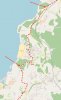
And it was pretty darn good! It’s a bit longer than the official route (12.8km total, or 2.7km longer), but that’s not horrible. Here’s what you get for that: a nice footpath through trees along the coastline, three different beaches (two of which you can definitely walk on and a third you should be able to eventually), two solid churches, and nearly non-stop coastal views. Here’s a map--the route I'm describing is in green, the official approach is in red (and that western spur of the official is a detour to Breamo).

Here’s some more detail: leaving Pontedeume, head to the train station, which is north of town. (Did I mention that this bypasses the entire climb out of Pontedeume?) Walk to the end of the station, cross the tracks, and join a trail running parallel to the tracks. This will periodically swing wide out to the coast and then veer back to the tracks. It eventually brings you to the Church of Centroña (2.3km), where you’ll pass in through the back, leave out the front gate and then arrive at a complicated intersection. Don’t pass under the railroad. Don’t follow the dirt road downhill towards the coast. Instead, follow the footpath climbing up alongside the railroad. A little while later, continue straight on a paved road. When that road turns left under the highway (900m), you have the diciest proposition of this walk, navigating a… let’s call it a footpath, up the hill straight in front of you, gradually looping to the right so that you wrap around the outside of the house, ultimately arriving at a minor highway. This worked fine for me, but it might be worse in spring/summer. You could also just follow the road as it winds around and joins the highway eventually—probably burning an extra half-km in the process.
Anyway, you’re on the DP-4803 now (turn right!). There’s no sidewalk here and minimal shoulder, but I only had 10 cars pass me and none in both lanes at the same time, so it didn’t feel unsafe. 800m later, shortly after passing a bar (for sale and closed at this time), turn right onto a footpath. It’s a good, established, obvious path, just before the road curves left. After a short descent, turn left on a beaten old asphalt road. Continue straight on this, ignoring cross streets, into the small beach town of Ber. Most everything seems out of business, though there is a bar still operating in the parking lot by the beach. Even the beach was closed when I was there! Seems like they’re maybe repairing the access steps. Not sure. My hope had been to descend to the beach and then follow a footpath up from the southern corner. Instead, I followed a road south from town, cutting hard back toward the coast on another small road. Worked just fine. Ber is 4.6km from Pontedeume.
700m later, fork left off the road onto a dirt track, just before a house. You’ll follow it uphill past two fields before it finally curves right, just along a hilltop. A short time later, it arrives at a T on a paved road. Turn left, then take the next right. When you arrive at the Igrexa de Santiago de Boebre, turn right again. This road curves a lot, but you’re sticking with it as it leads you along a stretch near the waterfront before ultimately arriving at the DP-4803 again (now with sidewalks!). You’re 7.2km from Pontedeume now.
Turn right on the DP-4803, but just for 200m, as it curves left. Soon after the road straightens back out, turn right downhill to the beach. This is the excellent Praia de Perbes. You’re going to walk the full length of the thing. It’s great. At the end of the beach, look for the trail kicked into the place where the tiny peninsula juts out from the coast. The first few steps are a little tricky, but climb over, curve left and then descend to the much smaller neighboring beach. Around the middle of that beach, you’ll find wooden steps leading to a track that brings you back to the highway. (Don’t go to the steps at the end of the beach; they lead to a locked gate!) Once on the highway, you’re 8.4km from Pontedeume.
You’re stuck on the highway for the next 2.4km, but there’s a sidewalk and the views are almost unfailingly great, especially as you approach Miño. Very soon after crossing the bridge to Miño, you can once again cross to walk along the beach (did I mention it’s huge?), or follow a wooden boardwalk parallel to the highway. This runs for a full kilometer. At the end of the beach, rejoin the highway as it curves inland, for a final km into the center of town (and to rejoin the Inglés).
I'll end with a few pics:
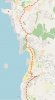
The trail near Pontedeume

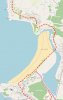
The Praia de Perbes

Miño Beach

So, I’ve been hunting around for ways to fix this (for my personal edification, at least)—or at least to better understand why the route exists as it does. And I can see now that a more coastal approach between Neda and Fene is impractical because of port business and train tracks, and Fene to Pontedeume would involve such a significant distance increase that I ruled it out as impractical. Miño to Betanzos is a maybe, but complicated because of the train, at least in the first third/half (I might try it someday). But… Pontedeume to Miño? Now, that looked interesting! So, I mapped out a plan and then followed it two days ago.
And it was pretty darn good! It’s a bit longer than the official route (12.8km total, or 2.7km longer), but that’s not horrible. Here’s what you get for that: a nice footpath through trees along the coastline, three different beaches (two of which you can definitely walk on and a third you should be able to eventually), two solid churches, and nearly non-stop coastal views. Here’s a map--the route I'm describing is in green, the official approach is in red (and that western spur of the official is a detour to Breamo).
Here’s some more detail: leaving Pontedeume, head to the train station, which is north of town. (Did I mention that this bypasses the entire climb out of Pontedeume?) Walk to the end of the station, cross the tracks, and join a trail running parallel to the tracks. This will periodically swing wide out to the coast and then veer back to the tracks. It eventually brings you to the Church of Centroña (2.3km), where you’ll pass in through the back, leave out the front gate and then arrive at a complicated intersection. Don’t pass under the railroad. Don’t follow the dirt road downhill towards the coast. Instead, follow the footpath climbing up alongside the railroad. A little while later, continue straight on a paved road. When that road turns left under the highway (900m), you have the diciest proposition of this walk, navigating a… let’s call it a footpath, up the hill straight in front of you, gradually looping to the right so that you wrap around the outside of the house, ultimately arriving at a minor highway. This worked fine for me, but it might be worse in spring/summer. You could also just follow the road as it winds around and joins the highway eventually—probably burning an extra half-km in the process.
Anyway, you’re on the DP-4803 now (turn right!). There’s no sidewalk here and minimal shoulder, but I only had 10 cars pass me and none in both lanes at the same time, so it didn’t feel unsafe. 800m later, shortly after passing a bar (for sale and closed at this time), turn right onto a footpath. It’s a good, established, obvious path, just before the road curves left. After a short descent, turn left on a beaten old asphalt road. Continue straight on this, ignoring cross streets, into the small beach town of Ber. Most everything seems out of business, though there is a bar still operating in the parking lot by the beach. Even the beach was closed when I was there! Seems like they’re maybe repairing the access steps. Not sure. My hope had been to descend to the beach and then follow a footpath up from the southern corner. Instead, I followed a road south from town, cutting hard back toward the coast on another small road. Worked just fine. Ber is 4.6km from Pontedeume.
700m later, fork left off the road onto a dirt track, just before a house. You’ll follow it uphill past two fields before it finally curves right, just along a hilltop. A short time later, it arrives at a T on a paved road. Turn left, then take the next right. When you arrive at the Igrexa de Santiago de Boebre, turn right again. This road curves a lot, but you’re sticking with it as it leads you along a stretch near the waterfront before ultimately arriving at the DP-4803 again (now with sidewalks!). You’re 7.2km from Pontedeume now.
Turn right on the DP-4803, but just for 200m, as it curves left. Soon after the road straightens back out, turn right downhill to the beach. This is the excellent Praia de Perbes. You’re going to walk the full length of the thing. It’s great. At the end of the beach, look for the trail kicked into the place where the tiny peninsula juts out from the coast. The first few steps are a little tricky, but climb over, curve left and then descend to the much smaller neighboring beach. Around the middle of that beach, you’ll find wooden steps leading to a track that brings you back to the highway. (Don’t go to the steps at the end of the beach; they lead to a locked gate!) Once on the highway, you’re 8.4km from Pontedeume.
You’re stuck on the highway for the next 2.4km, but there’s a sidewalk and the views are almost unfailingly great, especially as you approach Miño. Very soon after crossing the bridge to Miño, you can once again cross to walk along the beach (did I mention it’s huge?), or follow a wooden boardwalk parallel to the highway. This runs for a full kilometer. At the end of the beach, rejoin the highway as it curves inland, for a final km into the center of town (and to rejoin the Inglés).
I'll end with a few pics:
The trail near Pontedeume
The Praia de Perbes
Miño Beach

")