• Get your Camino Frances Guidebook here.
  • For 2024 Pilgrims: €50,- donation = 1 year with no ads on the forum + 90% off any 2024 Guide. More here.
    (Discount code sent to you by Private Message after your donation)
  • ⚠️ Emergency contact in Spain - Dial 112 and AlertCops app. More on this here.

Search 69,459 Camino Questions

Ridiculous new routes into Portomarín

jefferyonthecamino

http://www.barrerabooks.com/ - Guidebooks
Time of past OR future Camino
2021
Be warned that the two new routes into Portomarín from Vilachá are ridiculous and even slippery dangerous.

Until this year, the Camino just after leaving Vilachá made a right, crossed the small road that leads down to the highway and the Portomarín reservoir bridge, and just before the small cluster of trees in front of you made its way down to highway and bridge on a small (and steep) small paved road. Once on the highway, you then approached the bridge from the right.

With the changes this year, you now make a left on the road you encounter as you leave Vilachá and have two options:

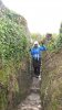
Op. 1 takes you down a VERY steep rock path down to the highway and bridge (not recommended if raining)
Op. 2 takes you down the road and then along the backside of a series of buildings (many which look abandoned), into a mess of garbage and mud (not recommended if raining).
Both of these options take you to the highway and bridge, approaching from the left.

* Next time I go through, it's the old route for me, too 'dangerous', ugly, dirty and muddy on the new routes.

Buen Camino
 
The 9th edition the Lightfoot Guide will let you complete the journey your way.
Transport luggage-passengers.
From airports to SJPP
Luggage from SJPP to Roncevalles
I used the old route last year. And was warning my wife this year that the descent into portomarin was very steep. She was getting sore shins...

So the new routes down that you outlined above took me by surprise.

Option 1 had warning signs and we avoided that.

Option 2 we found quite OK. And at least the descent is not as steep as the old route.

Not sure why they changed it though.....
 
Last edited:
I used the old route last year. And was warning my wife this year that the descent into portomarin was very steep. She was getting sore shins...

So the new routes down that you outlined above took me by surprise.

Option 1 had warning signs and we avoided that.

Option 2 we found quite OK. And at least the descent is not as steep as the old route.

Not sure why they changed it though.....
Congratulations Robo and suffering no lameness this year ,so glad you made it with your wife this year perigreno b and me wish you well. We won't be back again this year just had one of two operations for my kidneys but hope to make the trail to SDC next year sometime. b
 
Technical backpack for day trips with backpack cover and internal compartment for the hydration bladder. Ideal daypack for excursions where we need a medium capacity backpack. The back with Air Flow System creates large air channels that will keep our back as cool as possible.

€83,-
I took the slippery dangerous route into Portomarin - following crowd didn't see sign (my bad). Heading into Santiago tomorrow and that was most difficult thing on CF. A lovely young woman from Korea helped me down, I was terrified. Don't go that way unless it is dry and you are young and fit.
 
I was there about 4 weeks ago and thought the sign indicated that the left option was for bicycles and straight ahead for walkers so I took the route that proved to be ridiculous and I was glad when I finally reached the bottom. It is so steep with rocks that I was sitting down and sliding on my rear for some of it. I don't recommend it to anyone.
 
At Villacha Open Street Maps (OSM) shows two local roads, one to the left and one to the right. Both descend along ridges to the road that skirts alongside the reservoir, rather than the track which descends down the steep face between them. The road to the left has the shorter distance alongside the reservoir to the bridge.

When. I descended the marked path to Portomarin some years ago (on my first day) I recall wondering what was the purpose of the "guardians" of the path in this area in making it so difficult and potentially injury causing.

And having since walked the GR 65 in France and Spain I have encountered many more such potential injury inducing difficulties.

There seems to be a mind set that says just walking 800 km, or more, is not challenge enough.
 
Down bag (90/10 duvet) of 700 fills with 180 g (6.34 ounces) of filling. Mummy-shaped structure, ideal when you are looking for lightness with great heating performance.

€149,-
I had my only slip/fall of my Camino on those slippery rocks two weeks ago. Fortunately only bruises, but was just following a large group, none of whom saw the sign for the alternate option. It is ridiculously unsafe. At best it should be marked as 'risky option B'
 
I was staying at Casa Banderas in early May and the owner ( a very nice chap called Gordon) warned us all over dinner that "they" had altered the route of the Camino to accommodate a new Albergue. He commented that the new route had a couple of options, both of which would end in a mud bath. He recommended continuing on the old route which meant just remaining on the Tarmac and going straight over at the staggered crossroads. Which is what everyone (who was with us that night) did.
He also suggested rather than follow the signs into Portomarin just to do a left after going over the long bridge over the reservoir and save a long trek round the houses into Portomarin.
I'd also like to add that I learnt a new German word "Schlamm" on the Camino and a new Spanish word "mojado" look 'em up and weep!
 
Picture of my wife decending option 1 into Portomarin this past April. Rocks were a little slippery, but taking things slowly, not any real drama. It would not be a good idea in the rain at all. I am sure in a heavy rain that this trail turns into a fast flowing stream rather quickly.
 

Attachments

  • FB_IMG_1464451760420.jpg
    FB_IMG_1464451760420.jpg
    180.5 KB · Views: 86
Very light, comfortable and compressible poncho. Specially designed for protection against water for any activity.

Our Atmospheric H30 poncho offers lightness and waterproofness. Easily compressible and made with our Waterproof fabric, its heat-sealed interior seams guarantee its waterproofness. Includes carrying bag.

€60,-
I was staying at Casa Banderas in early May and the owner ( a very nice chap called Gordon) warned us all over dinner that "they" had altered the route of the Camino to accommodate a new Albergue. He commented that the new route had a couple of options, both of which would end in a mud bath. He recommended continuing on the old route which meant just remaining on the Tarmac and going straight over at the staggered crossroads. Which is what everyone (who was with us that night) did.
He also suggested rather than follow the signs into Portomarin just to do a left after going over the long bridge over the reservoir and save a long trek round the houses into Portomarin.
I'd also like to add that I learnt a new German word "Schlamm" on the Camino and a new Spanish word "mojado" look 'em up and weep!
Well, I shall be following JB's instructions as per his 2015 version as there's a steep staircase leading up to the arch & capela de Santa Maria de las Nieves at the entrance to Portomarin, which may be the way you went, which is very charming. Last time I took shelter there in wet weather! It is worth the effort! Cheers!
 
Ideal sleeping bag liner whether we want to add a thermal plus to our bag, or if we want to use it alone to sleep in shelters or hostels. Thanks to its mummy shape, it adapts perfectly to our body.

€46,-
I was staying at Casa Banderas in early May and the owner ( a very nice chap called Gordon) warned us all over dinner that "they" had altered the route of the Camino to accommodate a new Albergue. He commented that the new route had a couple of options, both of which would end in a mud bath. He recommended continuing on the old route which meant just remaining on the Tarmac and going straight over at the staggered crossroads. Which is what everyone (who was with us that night) did.
He also suggested rather than follow the signs into Portomarin just to do a left after going over the long bridge over the reservoir and save a long trek round the houses into Portomarin.
I'd also like to add that I learnt a new German word "Schlamm" on the Camino and a new Spanish word "mojado" look 'em up and weep!
I learned a similar word in Italian - "fango".
 
Be warned that the two new routes into Portomarín from Vilachá are ridiculous and even slippery dangerous. ...

* Next time I go through, it's the old route for me, too 'dangerous', ugly, dirty and muddy on the new routes.

I don't remember the old route - are there still signs that help you figure out the old route?
 
I don't remember the old route - are there still signs that help you figure out the old route?

Portomarin is one place that, for me, has a slightly confusing and vague entry. My first Camino in 2010 was fine, but in 2011 I walked it in the dark (a friend of mine and I encountered a full albergue in Ferreiros and decided to walk on to Portomarin but it was 9:30pm in October before we got there; even with flashlights, in the dark we missed the first turnoff and ended up walking on the road all the way around to the left (and thus approaching the long bridge from the left instead of right). In 2012 it was fine again, I could see where I'd missed the turnoff the time before and walked in as usual. But last year the turnoff was blocked and the route was changed to quite a steep downhill path compared to what I'd walked before. I plan to walk again this year and would really appreciate a good set of directions for how to get down to the bridge safely. I might just stick to the road if it seems too unclear. Or, could someone please post a Google maps image with the suggested (old way) route marked somehow? Many thanks if so!

Rachel :)
 
A selection of Camino Jewellery
I used the old route last year. And was warning my wife this year that the descent into portomarin was very steep. She was getting sore shins...

So the new routes down that you outlined above took me by surprise.

Option 1 had warning signs and we avoided that.

Option 2 we found quite OK. And at least the descent is not as steep as the old route.

Not sure why they changed it though.....

Robo:

The good point about option one is that it is so narrow you can actually hold both sides of the wall while going down. It is steep and very slippery when wet.

Ultreya,
Joe
 
Join our full-service guided tour of the Basque Country and let us pamper you!

Most read last week in this forum

The Burguete bomberos had another busy day yesterday. Picking up two pilgrims with symptoms of hypothermia and exhaustion near the Lepoeder pass and another near the Croix de Thibault who was...
Between Villafranca Montes de Oca and San Juan de Ortega there was a great resting place with benches, totem poles andvarious wooden art. A place of good vibes. It is now completely demolished...
Just an FYI that all available beds are taken in SJPDP tonight - fully, truly COMPLETO! There’s an indication of how busy this year may be since it’s just a Wednesday in late April, not usually...
Left Saint Jean this morning at 7am. Got to Roncesvalles just before 1:30. Weather was clear and beautiful! I didn't pre book, and was able to get a bed. I did hear they were all full by 4pm...
Hi there - we are two 'older' women from Australia who will be walking the Camino in September and October 2025 - we are tempted by the companies that pre book accomodation and bag transfers but...
We have been travelling from Australia via Dubai and have been caught in the kaos in Dubai airport for over 3 days. Sleeping on the floor of the airport and finally Emerites put us up in...

❓How to ask a question

How to post a new question on the Camino Forum.

Similar threads

Forum Rules

Forum Rules

Camino Updates on YouTube

Camino Conversations

Most downloaded Resources

This site is run by Ivar at

in Santiago de Compostela.
This site participates in the Amazon Affiliate program, designed to provide a means for Ivar to earn fees by linking to Amazon
Official Camino Passport (Credential) | 2024 Camino Guides
Back
Top