Dear Friends.
My name is Alexandre Fernandes, I’m the bike-pilgrim of Via Lusitana. It’s a pleasure to help you on your journey preparations”
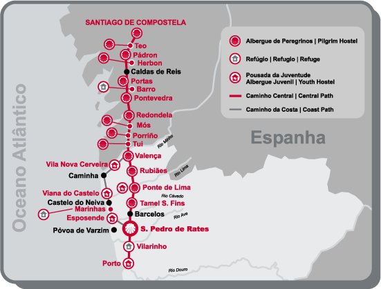
The Caminho Português to Santiago stretches along 690km (more or less). It crosses Portugal by the central line. Along 9 days, I covered the distance with an average daily distance of 80km to 90km. This is the safe distance that you should take during your ride, for it prevents extreme physical efforts, injuries and provides the time to enjoy the cities, views, landscape and people.
The track is an average difficulty one. There are no major problems (hill’s, mountains, etc.), except for a couple of points. But still, if you’re fit and healthy those should not be a real problem.
Along with the reading, you may visit my blog page. I’ll link the pages for each stage. It’s written on Portuguese, it was edited by my wife that used phone-pictures I’ve sent along the way. You may see the pictures, just to have an idea of the path.
Regarding the stages, my advice would be for you to divide it like this (having in mind that I only had 9 days)
Stage 1: Lisboa – Via Franca de Xira – Santarém – 95km
http://70ocean.blogspot.com/2009/03/cam ... dia-1.html
Easy flat ground. A mix of urban and dirt tracks but safe. You will enjoy the wine lands of central Portugal. Lot’s of spots to eat and rest. Nice landscape and you will have Rio Tejo (river), along the most part of the track.
The arrival to Santarém is made on a steep tarmac climb. It goes for 2km, and ends on the main central square in Santarém. This climb is only spot to look out, for those are the two last km of the day.
Stage 2: Santarém – Golegâ – Tomar – Alvaiázere – 97km
http://70ocean.blogspot.com/2009/03/dia-2.html
Mainly fields. The Tejo River shows itself once again. The ground is majorly flat between Santarém to Tomar. On the exit of Tomar, you’ll have to deal with Serra de Tomar. It’s a hard hill to cross, and the first of the day. I lost myself in there, but since last year, Via Lusitana remarked the path so there should be no problem.
After Serra de Tomar the path twists and rolls itself in a mix of climbs and downhills along the way until Alvaiázere. There are a couple of small hills. The woods and views are amazing. Probably some of the most beautiful tracks you’ll find.
Stage 3: Alvaiázere –Coimbra – Mealhada – 94km
http://70ocean.blogspot.com/2009/03/dia-3.html
Mainly the path is what we call a “leg-breaker”. Small hills that keep rocking your legs. A mix of tarmac and dirt tracks.
When exiting Alvaiázere, you’ll face another long but average hill. The distance (around 4km), makes it long on your head, but with a steady pace it will be on behind you pretty fast.
The path opens itself on the arrival to Coimbra (the major city of students). You’ll cross Rio Mondego (river) and arrive to one of the most beautiful Santiago Church’s. From Coimbra, you’ll face another hard climb up to Mealhada. This hill may be dangerous for you’ll be tracking some national roads. But with the needed attention you’ll be safe.
Stage 4: Mealhada – Águeda - Oliveira de Azeméis – 72km
http://70ocean.blogspot.com/2009/03/dia-4.html
The path to Águeda is quite easy. Mainly flat and open. You should pay attention to the north wind if it shows up. It tends to face you directly and makes it a bit harder.
From Águeda you’ll cross lots of fields and populations. Lots of major points of interest to visit and photograph. You should save your legs for the last 3,5km. These are probably the hardest one’s on your journey along with another stage (Serra da Labruja), that I’ll speak about later.
These 3,5km are the arrival to Oliveira de Azeméis. A tarmac old road. Very steep (10% to 12%). I’m experienced and I had to walk it hand-pushing my bike. Once in Oliveira de Azeméis, enjoy the main square. There’s an old club (The Art Clube 1833), totally renewed by the owners. A must see.
Stage 5: Oliveira de Azeméis – Porto – 60km
http://70ocean.blogspot.com/2009/03/dia-5.html
An easy day. Small distance that will take you to Porto the major city of the country. The only problem on this stage will by the Serra dos Negros (hill). A couple of km of climb of hard rock path, bumpy and uncomfortable. The hill will take you to Gaia, the southern side of the Douro River. Form Gaia, there’s no other option then to deal with the national road. Dangerous. Lot´s of traffic (trucks, cars, etc.) There’s no side line on the road so you’ll have the trucks on your shoulders. Be careful. All this will be forgotten when you arrive to Porto. The view and corssing is amazing. Enjoy Porto’s river downtown. Good food, good views, good wine, good beer.
Stage 6 Porto – Barcelos – 60km
http://70ocean.blogspot.com/2009/03/dia-6.html
Another average day. Mainly fields. You’ll cross fields and fields and fields of amazing colors. People are friendly. Take time to visit São Pedro the Rates (the path will take you there). Also make a stop at Pedra Furada Restaurant. António the owner is a Pilgrim helper for more then 25 years. There’s a pilgrim menu and a guest book for you to “write” down your mind.
From Pedra Furada to Barcelos the path is very smooth. Simple! Take some time to see the city (the entrance by the big ancient roman bridge is amazing)
Stage 7: Barcelos – Valença (last Portuguese city of the Caminho) – 74km
http://70ocean.blogspot.com/2009/03/dia-7.html
Leave Barcelos early. The day will be very hard. Believe me when I say this. You will face it yourself.
Once you leave Barcelos, The path will take to some major hill and downhills. Sometimes it can make wonder is this path are for real. They are, and your legs will show this. The path starts with Alto da Portel, a long climb up-hill with amazing viws, but hard on your legs. From Alto da Portela, you will have the chance to go downhill for a couple of km until you face the Rio Minho (river), valley. Along km and km, you’ll cross forgotten villages. Lot’s of roman bridges. Lots of “green”… and all this will take you to Ponte de Lima. Take a stop here. Enjoy the rest. Lot’s of monuments that you should visit. You’ll need this stop for from this moment one you’ll start a very long up-hill all the way to the top of Serra da Labruja (hill). This is considered the “black spot” of the Portuguese Caminho. On the first km the up-hill is smooth and you´ll be introduced to some steep climbs, that prepare (or ruin), your legs for the Labruja.
The path is a mountain one. No major roads. Secure and amazing.
Eventually the preparing hills will take to the Labruja path. It’s impossible do rde a bike here. The track is full of loose stones, twisted tree roots, hard 90º corners. But the worst part is the steepness. 18%. I had to carry my bike on my shoulder for more them 2km. On the path you’ll cross the French Crucifix. It’s impossible to miss it for there’s no other way. This marks the climb mid-point. Ahead the path becomes more difficult.
At the top of the hill, there’s a fountain, a mountain ranger house, shadows and a nice green grass field to rest. Take your time. Enjoy the view. The descent is also dangerous, although it’s not comparable to the up-hill you just finished.
Take your time to go down. Enjoy the ride. The descent will take you to Rubiães. Nice, small place to rest for a while. From here it’s an easy path to your destination (Valença)
Arriving to Valença will take to the inner-castle-walls of the ancient part of the city. It’s amazing. Enjoy it. And prepare yourself to say goodbye to Portugal.
Stage 8: Valença – Caldas de Reis – 93km
(no link for this day, my wife did not edit this. She went to get me at Santiago)
From Valença, take the road that leads to the Rio Minho (river). And old iron and steel bridge will cross you to Spain. On the other side of the margin you lose one hour (time difference between Portugal and Spain), so plan your day having this in mind. At 8h in Portugal it’s 9h in Spain.
When crossing the bridge have a minute to observe the river quietness and the abandon customs facilities on both sides. You enter Spain by the city of Tui. Visit the Catedral.
In Spain, the path does not present any major problems. On your way to Caldas de Reis you cross some woods, face some tarmac. Pay attention to the Porrino road. And industrial area with a stretch of 4km of tarmac loaded with trucks. Once you leave the Porrino there are a couple of steep of small hills on your way. The major one’s are the Cavaleiros Road, very steep but short. The other ones are easy to deal with.
The arrival to Caldas de Reis is made over the fields. Lots of fountains. Don’t drink the water.
Caldas is an ancient thermal city. There’s a fountain (lions fountain), the runs hot water. Take a moment to put your hands and feet under it. It’s fun, and strangely “refreshing”.
Stage 9: Caldas de Reis – Santiago Compostela – 45km
http://70ocean.blogspot.com/2009/03/cam ... o-70s.html
No major problems. Mainly fields and nice tracks. The day will start slowly. It’s the last day there’s no rush just the sureness that Santiago is near. The major difficulties of the day are the last hill that will take you to Milladoiro (from where you’ll see Santiago for the first time), enjoy the moment. From Milldoiro you’ll find a big tarmac downhill that will take to a roman bridge. That’s exactly where you start the last and final climb all the way to Obradoiro (the main square facing Santiago Compostela cathedral). Once you cross the bridge, a very, very, very, steep, but very short up-climb (300m), will break your legs. That’s your final effort to prove yourself that you can do it. It’s called the Hospital Climb.
From the Hospital, your 2lm away from Obradoiro. Forget the rest of the world and enjoy your arrival.
You are in Santiago. You’ve made it.
List of major cities you will cross
Lisboa - Alhandra, Alverca, Vila Franca Xira, Carregado, Vila Nova Rainha, Azambuja, Santarém, Golegã, Tomar, Alvaiázere, Ansião, Rabaçal, Condeixa, Coninbriga, Coimbra, Mealhada, Águeda, Albergaria (Velha), Alvergaria Nova, Oliveira Azemeis, São João da Madeira, Grijó, Porto, Araujo, São Pedro Rates, Pedra Furada, Barcelinhos, Barcelos, Ponte Lima, Rubães, Serra da Labruja, Valença do Minho, Tui, Porrinõ, Mós, Redondela, Pontevedra , Caldas de Reis, Padron - Santiago de Compostela.
Hope this helps. It will be a pleasure to provide any other info if needed.
My best Regards and wishes of safe and amazing journey.
May Santiago be with you along this crossing.
Alexandre Fernandes
http://www.vialusitana.org