Thanks for the info Castilian. As I zoom in I discover that there are different place names only 200-300 meters apart !
Based on the sketch, I was looking for San Román, not San Romao - it looks more like a hamlet than a village.
We actually followed the route past there, but later turned south on LU-P-4004. When I was planning this, I only had 1:400,000 Michelin maps, and I picked what looked like the most direct, non-busy roads. I suspect that it would only show numbered roads in an area like this, and perhaps not even all of those.
http://ridewithgps.com/routes/6872077
Looking at the map, there is a region ENE of Melide (around Serra do Careon - perhaps a national forest?) with no numbered roads. However, what is interesting is that if I zoom in, I discover that a surprising number of the very small roads are paved. The landscape is certainly a lot greener and more interesting than the Meseta, but then there is a lot more rain ;-) I almost wonder if more small roads are paved in Galicia because the rain takes such a heavy toll on dirt roads?
I may play with creating a road route into Melide from Lugo, but I think anyone attempting it would need to carry GPS gear, as there would be no other way to follow it.
I'm curious if walkers just follow the roads, or are there paths through the woods and fields sometimes?
Terry - since you've walked it, are there signs the entire way, or do you use detailed maps from guide books?
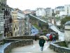
We saw a good number of walkers all the way to Palas de Rei, but don't know how this compares to the numbers on the northern route. It's possible that, like our group, walkers take the southern route just because it's more direct and easier to follow?
Charles


 . I would suggest that the route does not pass through any "villages", only scattered houses of hamlets!


