• For 2024 Pilgrims: €50,- donation = 1 year with no ads on the forum + 90% off any 2024 Guide. More here.
    (Discount code sent to you by Private Message after your donation)
  • ⚠️ Emergency contact in Spain - Dial 112 and AlertCops app. More on this here.

Search 69,459 Camino Questions

Sureste and Levante

murraydv

Via de la Plata / Portuguese / Ingles / Levante
Time of past OR future Camino
Via de la Plata, Portuguese, Ingles, Levante
Here is a very good chart that clearly shows where the Camino Sureste from Alacante and Camino Levante from Valencia coinside and differ. Obviously, they differ significantly at the beginning before joining in Chinchilla del Montearagón. Then they split and join several times until they split significantly again at Medina del Campo with Levante going to Zamora and Suresta going to Benavente. Both can they join either the Camino Sanabres or the Camino Francés. The Via de la Plata is also shown on the chart. Dave. levante.jpglevante.jpg
levante.jpg
 
Join our full-service guided tour of the Basque Country and let us pamper you!
This is fabulous. Years ago when I walked the Levante, the two associations were essentially “warring.” It was very confusing for pilgrims. It looks like the two groups have gotten together to provide clear info —I think it will benefit both Caminos a lot. Makes me much more tempted to go back and walk the Sureste!
 
The 2024 Camino guides will be coming out little by little. Here is a collection of the ones that are out so far.
What if you "mix and match" - e.g. sometimes taking the blue (Sureste) lines in the map above and at other times the green (Levante) lines? What determines which Camino you declare? Would that depend on where you started: Valencia or Alicante? Your thoughts would be appreciated.

Don.
 
Last edited:
St James' Way - Self-guided 4-7 day Walking Packages, Reading to Southampton, 110 kms
What if you "mix and match" - e.g. sometimes taking the blue (Sureste) lines in the map above and at other times the green (Levante) lines? What determines which Camino you declare? Would that depend on where you started: Valencia or Alicante? Your thoughts would be appreciated.

Don.
Don’t think it matter one way or another. When I walked the Sureste a couple of years ago I then continued on the Frances and then onto the Invierno. The pilgrim office were very confused and just asked me how far it was!
 
What if you "mix and match" - e.g. sometimes taking the blue (Sureste) lines in the map above and at other times the green (Levante) lines? What determines which Camino you declare? Would that depend on where you started: Valencia or Alicante? Your thoughts would be appreciated.

Don.
Good question Don. I thought of that myself. Can’t give you a definite answer but I would fully agree that the starting point would appear to determine that, together with your short interview in SdeC as they are filling out your Compostela.
 
Good question Don. I thought of that myself. Can’t give you a definite answer but I would fully agree that the starting point would appear to determine that, together with your short interview in SdeC as they are filling out your Compostela.

This matters more for statistical compilation than for you personally. For the compostela, they don’t need your starting point, they just give you the compostela if you declare a spiritual or religious purpose and if you have walked at least the last100 km from Santiago with no motorized transport. If you want a distance certificate, you should arrive with the info you want it to show — starting point, caminos walked, total kms.

But when it comes to the office’s records of “who walks which caminos” it gets more complicated, for them anyway. I think the Invierno is “victim” to this a lot, because many Invierno pilgrims start on another camino and then move over to the Invierno in Ponferrada. And so they never show up as Invierno pilgrims.
 
€2,-/day will present your project to thousands of visitors each day. All interested in the Camino de Santiago.
Thank you, MikeJS, Murraydv and Peregrina2000. Yes, they were a little bemused at the Pilgrim Office when I showed them my credencial in 2017 showing Seville to Salamanca, then transferring to the Portuguese at Coimbra and then on to Santiago.
 
I waited for 3 hour to be signed up as a number of the Invierno statistics, but I do not think I was, since the start was in Ponferrada and the man in the office did not understand English or my trying to speek Spanish. So next time I ˜ll spend my time on something more interresting than trying to get my n´te compostela
 
Ideal pocket guides for during & after your Camino. Each weighs only 1.4 oz (40g)!
Just as a matter of interest, how well are the different options signalled on the ground (as it were)? I will be walking with a route on maps.me to zoom in on and the guides reminding me where to be careful, but I’m interested to know how easy it would be to take the wrong way.
 
Join our full-service guided tour and let us convert you into a Pampered Pilgrim!
But the Lana is still missing!
But what an inspiring map ! I see the addition isn’t yet included either; of the way from Zamora (south of the Sanabrés) Via the corner of Portugal, to Ourense ?
(Camino Zamorano Portugues).

Buen Camino /( bom caminho).
Annie
 
Last edited:
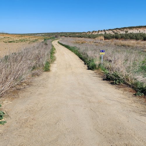
Hi Kiwi-family, I walked a mix of the Sureste and Levant in '14 and where the routes crossed there was usually a marker as in the photo, be aware there can be any number of routes sharing the same path, I remember one occasion somewhere near El Toboso where there were markers for :- Sureste, Levante, Camino Hannibal and Route Don Quixote on the same post!
Regards
George
 
Last edited:
Very light, comfortable and compressible poncho. Specially designed for protection against water for any activity.

Our Atmospheric H30 poncho offers lightness and waterproofness. Easily compressible and made with our Waterproof fabric, its heat-sealed interior seams guarantee its waterproofness. Includes carrying bag.

€60,-
Just as a matter of interest, how well are the different options signalled on the ground (as it were)? I will be walking with a route on maps.me to zoom in on and the guides reminding me where to be careful, but I’m interested to know how easy it would be to take the wrong way.
George.g give one of various examples, but in some ocasión those signs may fail.
If you check the description of the Levante on the web www.vieiragrino.com you will have an indication ( for example: *(Attention variant Southeast Way by Villanueva de Bogas street).) where is the point of bifurcation, and a waypoint has been added in the tracks of this web

But the Lana is still missing!
True, this Metro like map was initially intended to clarify the differences between Levante and Sureste. For a complete sight of formal ways the best information is the map of the IGN.
 
Last edited:
But the Lana is still missing!
The omissions are striking. It also erases the Camino Mozarabe in favor of some very eccentric routes from Almeria and Granada. The suggested route from Granada is labeled "Camino de San Juan de la Cruz," but that's actually not true. The Camino with that name is a short route near Murcia.

My take is that this is a map with a message. And while I don't mind graphics and diagrams with promotional intent, I feel that there's a line that separates biased communications from dishonest communications. This map falls on the wrong side of that line.
 

❓How to ask a question

How to post a new question on the Camino Forum.

Forum Rules

Forum Rules

Camino Updates on YouTube

Camino Conversations

Most downloaded Resources

This site is run by Ivar at

in Santiago de Compostela.
This site participates in the Amazon Affiliate program, designed to provide a means for Ivar to earn fees by linking to Amazon
Official Camino Passport (Credential) | 2024 Camino Guides
Back
Top