• For 2024 Pilgrims: €50,- donation = 1 year with no ads on the forum + 90% off any 2024 Guide. More here.
    (Discount code sent to you by Private Message after your donation)
  • ⚠️ Emergency contact in Spain - Dial 112 and AlertCops app. More on this here.

Using a netbook on the Le Puy route - practical?

BobM

Veteran Member
Time of past OR future Camino
V Frances; V Podensis; V Francigena; V Portugues; V Francigena del Sud; Jakobsweg. Jaffa - Jerusalem
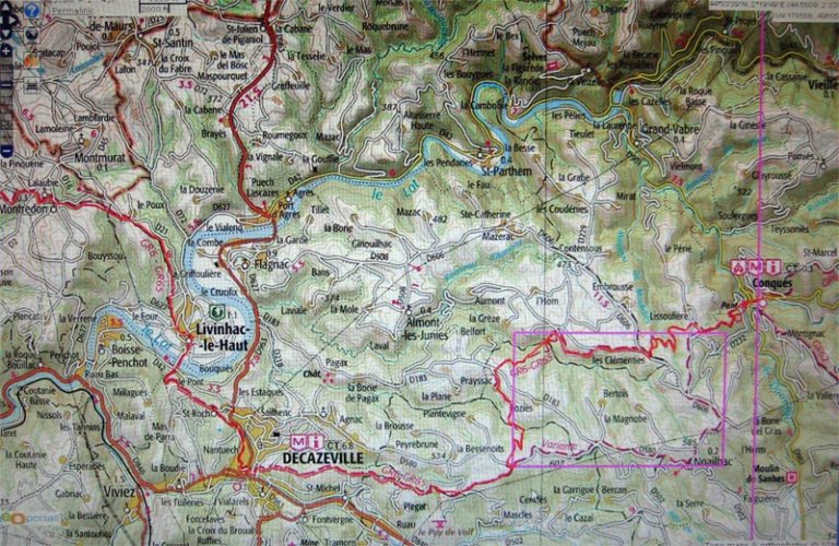
I am toying with the idea of taking a netbook with me, although the weight (1.3kg+) and size put me off. But it would be great for viewing the excellent IGN (F) maps and the online MMD maps, instead of taking the GR65 topo maps.

Does anyone have experience using a netbook on this route? Is wireless coverage usually available? Last year I had problems with mobile coverage on the SFR (?) network between Le Puy and Conques.

Any information on access costs would also be helpful.

Regards

Bob M
 
Technical backpack for day trips with backpack cover and internal compartment for the hydration bladder. Ideal daypack for excursions where we need a medium capacity backpack. The back with Air Flow System creates large air channels that will keep our back as cool as possible.

€83,-
Hey Bob! Just to let you know you're not alone w your thaughts. I'm planning a walk from Le Puy next fall and I'm so impressed with the detailed IGNmaps it would be great to have them along, but in paperform they'd make some load! The small laptop would be great, but how about plugging it in at the gites? Or a wireless acces, as you ask, is it possible to get it for a month?
On the Frances in 08 I saw some with the10" laptops, keeping journal, or even WORKING!
I know most think it's madness to carry a computer as the camino is supposed to take you away from everyday life. Still, being such a lover of maps this might be a solution.
And my small primus gas cooker, it came very handy on the Frances, so, from what I've read, it could be even more useful on the LePuy route?

Hoping for an answer too, Björn
 
You technophaeliacs are making me laugh, you don't need a thing on that route really, it is so well marked a half blind person could find the way.....I just lost my way once or twice, because I was thinking and failed to notice arrows turning off the track, but if you concentrate you can't loose your way, love Gitti
 
Ideal pocket guides for during & after your Camino. Each weighs only 1.4 oz (40g)!
A netbook would be handy for other things, but even with a poor sense of direction I was able, like gittiharre,to find my way just by following the markings. But, hey, if you love maps...

I wouldn't be without a little cooker for cups of tea or heating cans of cassoulet etc. I like to use a mini Trangia because there's nothing to go wrong.

I'd love to hear how you fare if you take the netbook.

Rob
 
gittiharre said:
You technophaeliacs are making me laugh, you don't need a thing on that route really, it is so well marked a half blind person could find the way.....I just lost my way once or twice, because I was thinking and failed to notice arrows turning off the track, but if you concentrate you can't loose your way, love Gitti

Gitti, we mapaholics just like maps :D It's a harmless fetish. We like to look at the contours and see the terrain in our mind's eye. We looove all those little symbols and marks that tell us so much. The GR 65 maps even show wayside crosses. Isn't that nice to know? You can pre-plan your prayers in advance, so no time is lost once you arrive at a cross. How efficient is that??

The fact that maps are also useful for navigation on the GR 65 is a minor matter, as you point out.

Please don't deny us our little obsessions :D

Best wishes

Bob
 
robertt said:
I wouldn't be without a little cooker for cups of tea or heating cans of cassoulet etc. I like to use a mini Trangia because there's nothing to go wrong. Rob

How much do those little cooker thingies weigh? Is there a website with pics etc? how about fuel? Bulky?

The Aussie military use small blocks of what I know as "hexamine" to heat food. The little foldaway stoves are very compact, but the blocks take up room - and they smell quite a bit.

It would be nice to cook some noodles while I am drooling over my maps in the wilds :D

Regards

Bob
 
€2,-/day will present your project to thousands of visitors each day. All interested in the Camino de Santiago.
Wifi is rare on the Camino Frances and even rarer on the Via Podiensis. Almost all wifi is password protected, so even when you find it, you probably can't use it. Any place with wifi also has a computer somewhere. My recommendation is to save the weight.

My digital camera takes detailed photos. I can zoom in and see topo detail. You might try your camera to see if you can use it to store maps.

Maps are pretty lightweight, and you can buy them successively along the route so that you do not carry more than two. I was very weight conscious, so I cut away the parts I did not need, and threw away sections and maps as I completed them! I think maps are great even when the path is well marked. The French have a way of routing you to scenic vistas even when there is a more direct route. When you are tired, you may prefer a direct route, and a map is helpful for that. When a calf muscle stopped working, it was nice to have a map showing the direct, and flat, road. A French companion succumbed to highway hypnosis on the way to Vaylats and ended up almost 10 km away, quite lost. Not being language deficient, she asked around and even got a ride. As a virtual English-only person, I would have preferred a map to get back on track.
 
I just finished a bike trip from the Italian border to Toulouse, via the new GR653A and the Arles route. I carried a netbook because the first half of the trip is a new route with inconsistant marking, no guidebook, and my gps files on the IGN maps were in it. Also my dog has health problems and I needed to stay in touch. I carry very little weight, so it was a big decision.

I found the 3G wireless services such as those from Orange or Bouyges were were really only available for a subscription, and if you are only there for a month and don't have a French account it would be hard to use them.

We stayed in hotels, and found wireless in at least half of them. Frequently they had no idea how their own network functioned, but they had one. Many restaurants have wireless as well. Wireless has wiped out internet cafes.

It was great for keeping track events back home, and for finding hotels and things on down the route. We rented a car in Toulouse a few days before we got there and it turned out it was a holiday, and without the reservation, which was at a very good price, we would have been stuck.

That said, I have gone from LePuy to Santiago, and unless I had a real pressing need to keep track of business back home I wouldn't take one on that route. I'd get the FFRP guidebooks as I went and use their nice maps, and a Garmin GPS with the Europe map package to fill in the rest if you are into maps. I would pick up a cell phone with a few cheap minutes and make reservations over the phone, which requires some, not much French and Spanish
 
Join our full-service guided tour of the Basque Country and let us pamper you!
newfydog said:
I found the 3G wireless services such as those from Orange or Bouyges were were really only available for a subscription, and if you are only there for a month and don't have a French account it would be hard to use them.
that's not correct. You can easily buy a PAYG dongle in France - at least in the larger places. Called a 'clé 3g'.
http://www.orange.fr/bin/frame.cgi?u=ht ... D300000088
http://www.laboutique.bouyguestelecom.f ... 62_sg.html

They're the same Huawei dongle as elsewhere, so if you already have one, you probably just need to find a SIM.

Same caveats apply as with mobile telephony: the networks are oriented to the larger population centres, which is not something you'll find a lot of on the GR65. Expect signal to be poor or non-existent in many places. (On the Paris route, you'd probably find a good signal most of the way.)

Despite being a fan of web mapping, I can't see the sense in taking along a netbook just for that. Are people suggesting you walk along with the thing in your hand? What happens if it rains? And how long would the battery last? And if you are thinking of printing out the maps every evening, why bother? You can pick up a TOP100 map (which is all you need if following a GR) in any newsagent, they cost only a few euro and weigh <100g. You need 5 for the whole route Le Puy-Navarra.
 
I found Wifi in bars, cafes, restaurants, public libraries and so on all the way along the Camino Frances - simply ask for the Clave - the password - which they are invariably happy to give - and you are on line. If your phone is an Iphone or Blackberry or a model of that type then there is no extra weight involved.
 
falcon269 said:
My digital camera takes detailed photos. I can zoom in and see topo detail. You might try your camera to see if you can use it to store maps.

That idea is a stroke of genius. I will do an experiment later and report back.

Regards

Bob M
 
Get a spanish phone number with Airalo. eSim, so no physical SIM card. Easy to use app to add more funds if needed.
falcon269's idea is quite practical.

This pic was taken with my Canon IXUS 850 compact and trimmed in Photoshop.

To take the pic I zoomed in on an IGN map on my computer to 1000m/cm and took the shot of the LCD screen (old CRT screens would not give as good results).

The original file size was about 50kb, so to upload it here I cut back the quality and size, so it looks more blurry than it is. In my camera I can zoom right down and see sharp detail. The limitation is the small camera screen size, so I have to use the little toggle control on my camera to move around the picture - but it is quite practical.

To cover the whole route I may use a separate memory card for maps.

Regards

Bob M
 

Attachments

  • GR65-Map-detail.jpg
    GR65-Map-detail.jpg
    149.7 KB · Views: 2,039
Very useful Bob, thank you. Could maybe enlarge that photo on the screen of an iPod Touch also.

I laughed when I saw which section you had photographed. Unless you have a need to go into the city of Decazeville, don't bother- take the high alternative route. (MMDD shows this alternative but I missed it.) It is a huge descent and a huge ascent into /out of Decazeville. Realising I had 'missed' the alternative higher route was just the icing on the cake of what was easily my worst day on the whole Chemin- partly for scary weather reasons -I got caught on high in a thunderstorm with no shelter- but also for some health reasons that wouldn't be pleasant to describe! But in hindsight, seeing this section of the map, I just have to laugh!
Margaret
 
Keep in mind that the chip will weigh at least 1/4 of an ounce. I hope you don't have to leave your sleeping bag behind to compensate.
 
A selection of Camino Jewellery
falcon269 said:
Keep in mind that the chip will weigh at least 1/4 of an ounce. I hope you don't have to leave your sleeping bag behind to compensate.

Very funny! ha ha :wink:

Bob M
 
KiwiNomad06 said:
I laughed when I saw which section you had photographed. Unless you have a need to go into the city of Decazeville, don't bother- take the high alternative route. (MMDD shows this alternative but I missed it.) It is a huge descent and a huge ascent into /out of Decazeville.
Margaret

Thx, Margaret. I plan to take the high road, for the reason you mentioned. Plus, Decazeville is eminently forgettable. Factage drove interminably around in the town dropping off bags when I took their transfer to Figeac last year.

Regards

Bob M
 
Peter Robins said:
newfydog said:
I found the 3G wireless services such as those from Orange or Bouyges were were really only available for a subscription, and if you are only there for a month and don't have a French account it would be hard to use them.
that's not correct. You can easily buy a PAYG dongle in France - at least in the larger places. Called a 'clé 3g'.
http://www.orange.fr/bin/frame.cgi?u=ht ... D300000088
http://www.laboutique.bouyguestelecom.f ... 62_sg.html

.

What have you found for prices Peter? I went to both stores, with a native French speaker for backup linguistic skills, and found I could get the service for about 30 euro a month, but the upfront costs were another 80 Euro. They also needed a French account to bill it to.
 
€2,-/day will present your project to thousands of visitors each day. All interested in the Camino de Santiago.
Bob,

Trangia cookers are light, especially the mini. The prob with the mini is that it won't operate well in wind. The larger Trangias will cook outside in driving rain, but there's more weight. Remember, however, much of the weight is also cookware. You don't take anything else, except a plastic fork or spoon. Fuel is metho, kept in a small bottle. Fuel consumption is light once you get the hang of quantities for boiling and draping the cap over the burner for simmering. They seem to have gone out of fashion, but I love 'em. I still have the one I bought thirty four years ago, and the mini which I took from Le Puy was bought seventeen years ago.

They're all over ebay in different sizes and combos. The Ultralight would be great, but it's a bit much for one person. The Mini is hard to find for some reason, but worth looking for. If you have a few Trangias you can leave, add and interchange pieces.

Rob
 
Hi Bob and others, of course you can have your little fetish as you call it obsessing over map detail, I am just a bit lazy when it comes to it....regards, Gitti
 
Hi Bob, just thought you might be interested in what I am planning for my next camino with regard to technology. Yes I like to take guide books and maps - but I am not what one could call obsessed with them. However, I am somewhat more obsessed with staying in contact with family and friends while I am away and do so by email as I don't own a mobile (and have no intention of owning one!). Neither have I figured out how to use the public phone system with confidence and so just rely on emails - quite happily I might add.

It is my intention, next time, to buy a Sony VAIO laptop. They are super light (the one I was looking at 6 months ago weighed 700 grams) and extremely strong. I intend to load voice recognition software onto it and use a compatable MP3 player to download my emails & my journal. I will then email the journal each time to myself (just as a security measure in case the laptop is stolen) where it can sit until I get time to deal with it at home. Apparently there are places where such things can be stored on the interernet. I never trust my journal to the post and so this will eliminate the weight of up to two journals from my pack. It will also mean that I can talk my thoughts into the MP3 player when I stop for a break - should I wish to. I don't like smaller keyboards as I type very quickly on a proper keyboard and it will also mean that I am dealing with the same keyboard instead of spending a lot of time editing because of typing errors caused by the vagaries of the French and Spanish keyboard. I will probably only buy it 30 days from departure so that I can claim the GST as I leave the country. This will still allow me enough time to get the voice recognition software working properly.

Last year on the Camino Del Norte I found internet cafes everywhere - but when I investigated them they were wireless ones and so I was unable to use them - thus this is another reason for the laptop plus an internet connection.

Cheers, Janet
 
€2,-/day will present your project to thousands of visitors each day. All interested in the Camino de Santiago.
For the mapaholics among us :wink: , I have photographed the IGN route maps from Conques to SJPDP at a scale of 1:23k. It requires 53 maps, allowing a little overlap between maps for ease of going from map to map in the sequence.

The actual photography is quite quick, maybe 30 min or so. Those maps would have been perfectly OK as they were, but I processed them a bit in Photoshop, and that took a couple of hours.

Anyway, the total space required for the 53 maps is 352MB. I took the pics at the best quality I could on my Canon so that the quality would still be good when I zoom in. I am quite impressed - I can zoom right in and the quality is very good.

I am also going to copy them to a USB memory stick to use when I can get access to a computer and have a bigger screen to view them on. Of course, this means an extra half-ounce of load that I will have to shed elsewhere :wink: Perhaps I could file down the handle of my toothbrush :)

My idea is to review the next day's route maps in the evening. Using my camera to do it on the road is less easy because the screen is hard to read in direct sunlight.

I will try to remember to give some feedback on how it all works.

Regards

Bob M(apaholic) :wink:
 
I am still intrigued with wifi access on the chemin, and appreciate the detailed and informative posts above. It is all very helpful.

I am a total novice re wireless internet (never used it at all), so perhaps some more expert folk could answer a couple more questions for me:

Suppose wifi is available at a location, how do you make the connection? Does the computer automatically detect the network and show an appropriate screen, or do you have to find it by looking for it in Windows Control Panel somewhere?

Once you have a wifi connection, is it secure? Could you safely do internet banking, or make credit card transactions, for example?

Regards

Bob M
 
newfydog said:
What have you found for prices Peter? I went to both stores, with a native French speaker for backup linguistic skills, and found I could get the service for about 30 euro a month, but the upfront costs were another 80 Euro.
I didn't say it was cheap :) It's much more expensive in F than here in GB. Don't know where you're getting the 30 euro from; you buy topups for a certain no of hours to be used within a month. And as usual you have to examine the small print to find out what other restrictions there are.

I wasn't meaning you should actually buy from those online stores, which are oriented to buyers in France. A quick web search reveals Bouyges and SFR both have shops in Le Puy, and I expect Orange has one too, and there may well be some independents too. If I were wanting to go that way, I would go into those shops and see what they can offer. Helps if you speak French of course :)

Another possibility is to use a phone with a built-in 3g modem which can be connected to a laptop via usb. Anyone who has one of those would then just need a SIM for one of the French networks. Again, the local shops could advise on the best deals.
 
Down bag (90/10 duvet) of 700 fills with 180 g (6.34 ounces) of filling. Mummy-shaped structure, ideal when you are looking for lightness with great heating performance.

€149,-
Peter Robins said:
A quick web search reveals Bouyges and SFR both have shops in Le Puy, and I expect Orange has one too, and there may well be some independents too.

I bought a SIM card for the SFR network in Le Puy last year. There is certainly an Orange shop there. Actually, Orange is the better choice re coverage, at least between Le Puy and Conques.

My SFR connection did not work at all in a couple of places, and in one other town it would only work in front of the church (perhaps a different network?)

Regards

Bob M
 
I must say the idea of maps on ones camera is growing on me, a very clever idea......must get my husband onto that one, I tend to be a little primitive on that front, mild technophobia perhaps.... Gitti
 
Very light, comfortable and compressible poncho. Specially designed for protection against water for any activity.

Our Atmospheric H30 poncho offers lightness and waterproofness. Easily compressible and made with our Waterproof fabric, its heat-sealed interior seams guarantee its waterproofness. Includes carrying bag.

€60,-
gittiharre said:
I must say the idea of maps on ones camera is growing on me, a very clever idea......Gitti

I was instantly converted as soon as I saw the falcon's post :D

Of course, the proof of this particular pudding will be how practical it proves to be in the field. Scrolling around the small screen on the camera might be a pain. Anyway, I will be giving it a go.

Regards

Bob M
 
robertt said:
Bob,

Trangia cookers are light, especially the mini. ...They're all over ebay in different sizes and combos. The Ultralight would be great, but it's a bit much for one person. The Mini is hard to find for some reason, but worth looking for. If you have a few Trangias you can leave, add and interchange pieces.
Rob


Rob, I Googled and found quite a few links, incl this one:
http://www.cmmonline.co.uk/items/defaul ... ef=Froogle

Is the Mini Trangia shown on the site the same as yours?

Regards

Bob M
 
BobM said:
robertt said:
Bob,
Rob, I Googled and found quite a few links, incl this one:
http://www.cmmonline.co.uk/items/defaul ... ef=Froogle

Is the Mini Trangia shown on the site the same as yours?

Regards

Bob M

I've got a mini-trangia like that. Unless there is no wind, you need to rig up some sort of windshield for it. It is very good. I didn't take a stove when I walked the Camino Levante last year as there are enough places to get relatively inexpensive hot drinks and food,

Andy
 
St James' Way - Self-guided 4-7 day Walking Packages, Reading to Southampton, 110 kms
Yep, that's a slightly modernised version of my mini. I don't get how they can claim it's stormproof. Possibly the advertisers apply the same claims to all Trangias. Andy's quite right: the mini is completely different to the larger Trangias and is obviously quite open to wind and weather. Terrific in a tent or sheltered spot.
 
As a technophile, what I can say is that the mobile phone (like the iPhone or the Android Phones) is becoming more like a computer.

That said, one still needs to be technically savvy to get everything from emails to maps installed and working on these devices. Also, there is the slightly smaller screen (compare with a netbook) to contend with. From cellular to wifi, it can almost anything a netbook can do. And it's lighter.

A netbook weighs in around 1 kg but is easier GTD (Get things done) tool to configure and use. So if the weight is not an issue and hacking a phone to do all that is not a good use of one's time, then by all means walk with a netbook.
 
well, I am a technogeek, but there are large numbers of features of my phone I've never or rarely used. There are so many options, and it's to remember which button you have to press for what - perhaps I'm just getting old.

I don't think the technology for maps whilst on a walk is really there yet. At least for me there's no substitute for a good paper map. But in a year or two some kind of mobile devices with good maps could well be commonplace. I read articles about foldable computers, or ones you can roll up, that researchers are working on, so who knows what might be around in a few years time.
 
A guide to speaking Spanish on the Camino - enrich your pilgrim experience.
Peter,

Agreed. Still it is a bit into the future. If one can't wait and still requires some mapping software, I can see only Nokia (the models with Ovi Maps) as an option. Nokia also tend to be a lot efficient in the battery consumption compared with the iPhone and especially the Android phones.

I've also discovered that many applications from both the iPhone or the Android are engineered to suck data from the internet, whist Nokia's current models tends to sip, if at all. Even with a prepaid sim, the data can get expensive.

The Ovi maps from Nokia can be pre-download locally, which will help tremendously in the camino environment. With the A-GPS, you can also locate your current position in relation to the maps. I wonder if anyone has tested it on the actual camino route?
 
evanlow said:
..... the mobile phone (like the iPhone or the Android Phones) is becoming more like a computer..... the slightly smaller screen (compare with a netbook) to contend with.

I played around with map images in my Canon IXUS compact camera with 5cm x 3.5cm screen and my initial enthusiasm has cooled a bit.

The maps are certainly usable, but scrolling around on the small screen is a pain and will consume lots of battery power. I also discovered that the in-camera images blur more than I expected when zooming in, whereas on my computer I can zoom right in with good quality. Not sure why this is so - maybe my computer screen has more pixels/cm than the camera LCD screen.

I will certainly take the camera maps on my next walk (plus copies on a USB stick), and see how much I like to use them in that setting.

Regards

Bob M
 
evanlow said:
I've also discovered that many applications from both the iPhone or the Android are engineered to suck data from the internet, whist Nokia's current models tends to sip, if at all. Even with a prepaid sim, the data can get expensive.
that's actually a very good point. My topo map pages are also very download-intensive - not a problem if you're on a fixed-line connection with a large monthly download allowance, or using the wifi in a bar or hotel, but mobile networks are generally very limited in that respect.
 
Join our full-service guided tour of the Basque Country and let us pamper you!
I had a look at the Ovi maps. They are quite good, a bit like the Google maps. But neither the Ovi nor Google maps have contours, although maybe there are ways to get contours if you know those systems well. I didn't explore in any detail.

The online IGN maps have contours that appear once you zoom in to the smaller scales. Contours are very useful.

Regards

Bob M
 
BobM said:
Suppose wifi is available at a location, how do you make the connection? Does the computer automatically detect the network and show an appropriate screen, or do you have to find it by looking for it in Windows Control Panel somewhere?

Once you have a wifi connection, is it secure? Could you safely do internet banking, or make credit card transactions, for example?

You can set your computer (or iPhone) to automatically detect available wifi networks. You can separately set whether to join an available network automatically or manually. When a network is available you will see an icon in the lower right corner (for Wintel machines).

Wifi security is nearly nil - you'll want your own machine password protected. A public, unprotected wifi network is rather like having the entire town connected to your in-house network; only individual passwords and firewalls provide protection. You should not access any personal financial or other sensitive information absent an additional layer of security such as VPN, as your account numbers and passwords can easily be sniffed.
 
Kitsambler said:
You can set your computer (or iPhone) to automatically detect available wifi networks. You can separately set whether to join an available network automatically or manually. When a network is available you will see an icon in the lower right corner (for Wintel machines).

Wifi security is nearly nil - you'll want your own machine password protected. A public, unprotected wifi network is rather like having the entire town connected to your in-house network; only individual passwords and firewalls provide protection. You should not access any personal financial or other sensitive information absent an additional layer of security such as VPN, as your account numbers and passwords can easily be sniffed.

Thx. That's extremely helpful. You certainly confirmed my suspicions about WiFi security - or lack thereof.

Re your second comment on security, does that mean (1) use only password-protected networks, and (2) VPN as well? Or does the actual computer need its own password protection as well (ie 3 layers of security?)

I have not looked at setting up a VPN. Is it something a novice can easily do by following Windows Help? Or are there arcane bits of knowledge/jargon involved that may not be intuitive to a novice?

Much obliged.

Bob M
 
New Original Camino Gear Designed Especially with The Modern Peregrino In Mind!
BobM said:
I had a look at the Ovi maps. They are quite good, a bit like the Google maps. But neither the Ovi nor Google maps have contours, although maybe there are ways to get contours if you know those systems well. I didn't explore in any detail.

The online IGN maps have contours that appear once you zoom in to the smaller scales. Contours are very useful.
A very good point. I believe Google Earth has that info. There are currently no offline option for Google Earth.

On the netbook, you can still increase the cache memory large enough to go one pass over the contour you desire on the camino and use the cached data later in the offline mode.

No such option for Google Earth on the iPhone. Not sure about the Android.

Someday and soon, we will have that. I hope.
 
Kitsambler said:
Wifi security is nearly nil - you'll want your own machine password protected. A public, unprotected wifi network is rather like having the entire town connected to your in-house network; only individual passwords and firewalls provide protection. You should not access any personal financial or other sensitive information absent an additional layer of security such as VPN, as your account numbers and passwords can easily be sniffed.
that seems to me to be confusing 2 separate issues. When you're logged on to a network, using wifi or any other means, anyone else on the network (who knows how) can access your computer and/or monitor the data going in and out of your computer. Protecting your machine with a password and/or firewall will prevent the first, or at least make it more difficult. Encrypting the private data on your disk makes it more difficult still to access. Some security-minded people keep sensitive info on a separate encrypted usb stick.

Whether they can do anything with the second again depends on whether it's encrypted or not. Log in to any decent online bank will be using SSL (https:// in the url, not http://) which is encrypted - if your bank doesn't use this, i.e. your bank doesn't care about security, change bank. Most email services, like gmail, also provide https:// access. There's a well-known technique for intercepting this - see for example http://www.informationweek.com/news/sec ... =214501930 - but as long as you make sure you are always in https mode, i.e. the traffic between your browser and the bank is always being encrypted, there is next to no risk.

In any case, people up to no good concentrate on places where they are likely to get a reward for their efforts, so are far more likely to be lurking in say the airport lounge at CDG than some small-town bar in rural France. And be aware that a much simpler way of getting access to your computer is to wait till you go to the loo or whatever and then steal it.
 
evanlow said:
Peter,
With the A-GPS, you can also locate your current position in relation to the maps. I wonder if anyone has tested it on the actual camino route?

On my last trip I had the route in my Garmin Dakota with the Garmin
Europe map package. I also had some maps, but if I had to give up one, it would have been the maps. At a questionable intersection I'd zoom in and the GPS would tell me in about 10 meters if I took the right route. The map package in the GPS had most of the small dirt roads, but it was not so good fo getting the big picture.
 
Ideal pocket guides for during & after your Camino. Each weighs only 1.4 oz (40g)!
Peter Robins said:
When you're logged on to a network, using wifi or any other means, anyone else on the network (who knows how) can access your computer and/or monitor the data going in and out of your computer. Protecting your machine with a password and/or firewall will prevent the first, or at least make it more difficult. Encrypting the private data on your disk makes it more difficult still to access.

Whether they can do anything with the second again depends on whether it's encrypted or not. Log in to any decent online bank will be using SSL (https:// in the url, not http://) which is encrypted - if your bank doesn't use this, i.e. your bank doesn't care about security, change bank. Most email services, like gmail, also provide https:// access. There's a well-known technique for intercepting this - see for example http://www.informationweek.com/news/sec ... =214501930 - but as long as you make sure you are always in https mode, i.e. the traffic between your browser and the bank is always being encrypted, there is next to no risk.

This is all very helpful to novices like me. I really liked the link in Peter's quote above. I found it very informative There should be a FAQ somewhere to retain all this stuff. Maybe Ivar already has one somewhere - or maybe there are online FAQs for this stuff in the computer world.

Anyway, can I assume that it is "quite safe" to use wifi provided one has decent anti-virus software, a firewall, and diligently uses only https sites?

I really appreciate the help. I am sure many other users also wonder about security from time to time.

Regards

Bob M
 
BobM said:
Anyway, can I assume that it is "quite safe" to use wifi provided one has decent anti-virus software, a firewall, and diligently uses only https sites?
you need a firewall to block access to your computer; a password's ok, but a firewall is safer. That applies whether you're using wifi or not. At home, if you access the internet via a router, then the router includes a firewall which blocks access from the internet. If your connection to the router is via cable, then outsiders have no access, but if your connection is via wireless then outsiders can access your router, so the router needs to be secured with a password. If you're using a public wifi 'hotspot', their router will block access from the internet, but anyone else using the same hotspot/router will have access to your computer (and you to theirs), so you need an additional block on your computer to prevent that.

As for https, you only need that for sensitive info. If all you're doing is finding train times or reading someone's blog, there's no secrets in that, so it doesn't have to be encrypted. But any sensitive info, whether you're accessing your bank acct or sending credit card details to buy or book something, should be encrypted. That applies whether you're using wifi or not.
 
Thx, Peter.

Here is a link to wireless security on Wikipedia that has a lot of very detailed information as well.
http://en.wikipedia.org/wiki/Wireless_security

It has more technical information than I need and is not always easy for a non-expert to follow.

Another point occurs to me: Can one still be vulnerable by using an unknown computer in a gite or internet cafe that has malware installed such as a key-stroke logger. Would the logger harvest say credit card details even using a "https:" website, before they are encrypted?

Regards

Bob M
 
€2,-/day will present your project to thousands of visitors each day. All interested in the Camino de Santiago.
You are absolutely correct on that point: Any public computer can easily have a keylogger installed (even without the owner's knowledge), and it will collect all keyboard activity, including passwords and credit card numbers, making an end run around such security as SSL (https). One really must be a bit cautious I'm afraid.
 
Kit,

To be safe on the camino, I carry a usb drive with these 2 programs.

1. Portable Firefox Browser.

Safer to use your own browser running on your own USB then to do one from the cybercafe.

http://portableapps.com/apps/internet/firefox_portable

2. A keyboard program like Neo's safekeys to enter passwords.

Open this program on your USB drive and click your passwords on the visual keyboard instead of typing it to prevent keyloggers from getting your password.

http://www.aplin.com.au/neos-safekeys-2008

You just don't know when those cybercafe PCs has been...
 
Thx again for more useful stuff. I will take Firefox and Safekeys with me. They are good apps even for non-sensitive uses involving passwords. Of course, one must remember to check the USB drive on returning home in case it has been infected :(

Even with all the protections discussed here, I don't think I will be doing any internet banking while on the road!

Regards

Bob M
 
A guide to speaking Spanish on the Camino - enrich your pilgrim experience.
BobM said:
... Of course, one must remember to check the USB drive on returning home in case it has been infected :(
Bob M

Good point. I use a micro-sd card with a reader. After copying the programs, I write protect the micro-sd card. Together they are even smaller than a normal usb thumb drive. No pesky malware is going to infect my drive, :)

Micro-SD write protect
http://www.ehow.com/how_4794876_remove- ... -card.html

Micro-SD keychain reader.
http://www.coolest-gadgets.com/20080604 ... -keychain/
 
evanlow said:
I use a micro-sd card with a reader. After copying the programs, I write protect the micro-sd card. Together they are even smaller than a normal usb thumb drive. No pesky malware is going to infect my drive, :)

Talking of mini things, I can't recall a web reference to quote, but you can get all sorts of "thin apps" to take on a USB drive - compact word processors, spreadsheets etc etc - so you are not dependent on apps in unknown computers.

If only I could get a "thin MMD" guidebook :lol: , instead of the too-wide printed book that is too big to carry in a pocket :cry: I need my guidebook instantly to hand, so last year I had to stuff MMD in the waistband of my pants, ruining their look of exquisite chic :roll:

Regards

Bob M
 
BobM said:
Here is a link to wireless security on Wikipedia that has a lot of very detailed information as well.
http://en.wikipedia.org/wiki/Wireless_security
that's about securing corporate networks, which is a related but different issue

At the end of the day, wifi hotspots are set up for convenience and there is always a trade-off between convenience and security. Putting extra locks and burglar alarms on your home will make things more difficult for burglars but also increase the inconvenience for you. No system is foolproof: ATMs can be tampered with, as can phones. Bank employees can be corrupt or disaffected (a common source of problem). If we spent all day worrying about these things, we'd never get anything done.
 
Join our full-service guided tour of the Basque Country and let us pamper you!
BobM said:
If only I could get a "thin MMD" guidebook :lol: , instead of the too-wide printed book that is too big to carry in a pocket :cry: I need my guidebook instantly to hand, so last year I had to stuff MMD in the waistband of my pants, ruining their look of exquisite chic :roll:

Regards

Bob M

Well Bob, with technology these days, you can do anything. As long as you have either a pdf, word, text or html of a document/guide you can easily add/convert it to be carried with you.


Here's a screenshot of a pdf on an iPhone. You can image how much pinching and zooming back and forth is required to read something like that on a phone. It might still be ok if you only reference it once a day.


Books (mostly text) are easier as they are mostly text and there is not the need to mess with the zooming.
 

Attachments

  • Mobile Photo Jun 30, 2010 3 42 30 PM.jpg
    Mobile Photo Jun 30, 2010 3 42 30 PM.jpg
    46.1 KB · Views: 1,176
  • Mobile Photo Jun 30, 2010 3 52 18 PM.jpg
    Mobile Photo Jun 30, 2010 3 52 18 PM.jpg
    73.7 KB · Views: 1,174
Back
Top