• For 2024 Pilgrims: €50,- donation = 1 year with no ads on the forum + 90% off any 2024 Guide. More here.
    (Discount code sent to you by Private Message after your donation)

Search 69,459 Camino Questions

Walking from Camino to Santiago Airport: Has anyone done it before and how to do it?

Status
Not open for further replies.

Chris Day

Hesed Walker
Time of past OR future Camino
Frances-14/15/16 Part-17/18/19/20
VdlP/Sanab/Finist 16
Port/Ingles 17
Norte 18 Le Puy&Prim 19
I have walked into Santiago at the end of various Caminos 13 times in the past and for a change, I am thinking of coming off the Frances Route after O Pedrouzo and simply walking into the Airport to fly home.

My question is, has anyone ever done that? ....and if so, how did you do that?

I recall walking along the Camino path around the runway perimeter fence and walking through a tunnel on the Camino path that passes under a road that runs to the airport, just after San Paio. Is there a path that runs alongside that road, or similar a little further along? Or can one walk alongside the perimeter fence to the airport main entrance perhaps?

Thanks for any help with this.
 
€2,-/day will present your project to thousands of visitors each day. All interested in the Camino de Santiago.
I have walked into Santiago at the end of various Caminos 13 times in the past and for a change, I am thinking of coming off the Frances Route after O Pedrouzo and simply walking into the Airport to fly home.

My question is, has anyone ever done that? ....and if so, how did you do that?

I recall walking along the Camino path around the runway perimeter fence and walking through a tunnel on the Camino path that passes under a road that runs to the airport, just after San Paio. Is there a path that runs alongside that road, or similar a little further along? Or can one walk alongside the perimeter fence to the airport main entrance perhaps?

Thanks for any help with this.
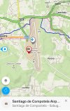
Looks doable to me - the dark blue line is the Camino, and the pink dotted line is the route for cyclists.

Screenshot_20220127-130304_Windy Maps.jpg
 
not so difficult, just stop following the Camino signs, when they lead you to the right, towards San Paio...keep walking straight on the road and the main entrance appears after 10min.
but isn't it a sad way to end a Camino, :( without enjoying the magical city?

Even if you think you know the city well, than you don't! Santiago provides always surprises:)
 
Last edited:
Get a spanish phone number with Airalo. eSim, so no physical SIM card. Easy to use app to add more funds if needed.
Very light, comfortable and compressible poncho. Specially designed for protection against water for any activity.

Our Atmospheric H30 poncho offers lightness and waterproofness. Easily compressible and made with our Waterproof fabric, its heat-sealed interior seams guarantee its waterproofness. Includes carrying bag.

€60,-
Windy Maps looks like a very useful app to have.
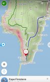
It is! In addition to most of the Camino routes being built into the maps it also has tons of other walking and cycling trails. I used the app to find the alternate route to the lighthouse in Finisterre that brings you there from above the lighthouse.

20220128_000248.jpg

20220128_000042.jpg
 
Thanks to all for the above responses and for the helpful comments/observations and maps. All I recall are very busy roads around that area, so the cycle path appears very helpful in that respect.
For the whole upcoming planned Camino, I am ringing-in the changes along a route I've done lots of times before - and still love very much, as I have always found it personally very rewarding. This idea effectively creates an extra day in my allotted time/schedule for one of my "variations", ending in a relatively short walk to the airport ("VN walking" 😉)
Sounds like "pasiño a pasiño" appears to have done it, which was also what I was hoping to hear from someone.
Thanks again.
 
It is! In addition to most of the Camino routes being built into the maps it also has tons of other walking and cycling trails. I used the app to find the alternate route to the lighthouse in Finisterre that brings you there from above the lighthouse.

View attachment 117384
i like this option! When i walked there appeared a ruin (i think it was a chapel) out of the fog and inside i saw ancient stone coffins. Mysterious place.
 
Join the Camino Cleanup in May from Ponferrada to Sarria. Registration closes Mar 22.
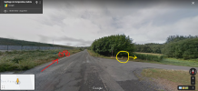
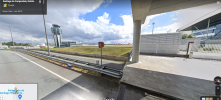
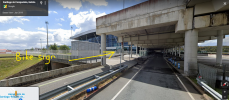
You can see the branch off on Google StreetView
1643370060284.png

Footsloggers turn right (there is/was a mojon circled yellow); bikers straight on.
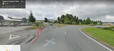
Looks like you share the highway with cars until the roundabout by the Spanish Air Force base and then get a dedicated cycle path

1643370317224.png

Eventually ending up in the terminal

1643372347912.png

1643372442136.png

If you use GoogleEarth then the attached KMZ file might be of interest.
 

Attachments

  • cycle to airport.kmz
    866 bytes · Views: 4
Not an answer but relevant ish. I walked back from Santiago to lavacolla, had a night there then walked down the main road to the airport it was 6am, dark, foggy and quite a horrible scary walk. I wouldn't recommend doing that!
 
3rd Edition. More content, training & pack guides avoid common mistakes, bed bugs etc
You can see the branch off on Google StreetView
View attachment 117385

Footsloggers turn right (there is/was a mojon circled yellow); bikers straight on.
Looks like you share the highway with cars until the roundabout by the Spanish Air Force base and then get a dedicated cycle path

View attachment 117386

Eventually ending up in the terminal

View attachment 117390

View attachment 117391

If you use GoogleEarth then the attached KMZ file might be of interest.

Thank you so much, Jeff....very, very helpful to see the option.
Chris
 
not so difficult, just stop following the Camino signs, when they lead you to the right, towards San Paio...keep walking straight on the road and the main entrance appears after 10min.
but isn't it a sad way to end a Camino, :( without enjoying the magical city?

Even if you think you know the city well, than you don't! Santiago provides always surprises:)
Walk to the city. Get your Compostela and see more of Santiago and then walk the few Kilometres back to the airport or get a bus.
 
The one from Galicia (the round) and the one from Castilla & Leon. Individually numbered and made by the same people that make the ones you see on your walk.
It doesn't make sense. Perhaps OP should do a Camino he hasn't done previously. I don't think by doing what he is suggesting doesn't make him a pilgrim, just a hiker.
VNwalking understands the reasoning behind my thinking I believe, Martin. Some of these 13 Cominos I have walked in the past involve two "routes" - VdlP followed immediately by Ingles, for example on one occasion. I have walked 9 routes and simply choose to "ring the changes" in how I construct this upcoming one. By walking into the airport I gain time (a day) to innovate ingredients in the route proposed. Somebody PM'd me yesterday about by Forum Handle - "Hesed Walker" - which after investigation of the word that was new to her, had blessed her greatly. My PM response to her included the following, as her Forum name included the word "Pilgrim".. I believe my reply to her clarifies my own motivation, not that I should need to make one.....

....but your (Camino Forum name) is very good too! I say this because I started my Camino history as a "walker"/"hiker" but much to my surprise and bit by bit, I found that I was becoming a "Pilgrim" and discovering the true meaning of what pilgrimage is. The Caminos have been extraordinary and transformative for me - some of which cannot be explained, humanly-speaking ....I am still learning though!

Since joining this helpful and delightful forum in 2014, this is my first question ever posed. If I could close this thread now (having received helpful and informative replies) then I would.
 
A selection of Camino Jewellery
Since joining this helpful and delightful forum in 2014, this is my first question ever posed. If I could close this thread now (having received helpful and informative replies) then I would.
Since your question about how to turn from the Camino Frances into a road/path leading to Santiago airport has been splendidly answered in a number of very helpful posts by, to name but a few, @trecile, @wisepilgrim and @Jeff Crawley, allow me to contribute to the thread drift. I'm sorry that somebody tried to derail the thread by airing their personal idea of how and where and why your or everybody else's Camino and their own future and first Camino Frances must end.

You can ask the moderators to lock the thread for you if you consider it as complete. I start to wonder whether it would not be good if we get the option to close a thread ourselves when we had started it. I know that such options exist on other social media forums.

I had not noticed your handle "Hesed Walker" and, being a non-native speaker of English, I had to look up the meaning of the word. I like it!

BTW, there is a Camino mojon even inside the airport of Santiago de Compostela. I know it because I've been there and took a photo 😊. I am glad that you posted a first question and I hope to read more from you from time to time. Buen camino wherever you go.
 
It doesn't make sense. Perhaps OP should do a Camino he hasn't done previously. I don't think by doing what he is suggesting doesn't make him a pilgrim, just a hiker.
That seems a bit harsh. Trying to get my head around the double negative in your last sentence. If you "don't think by doing what he is suggesting doesn't make him a pilgrim, just a hiker" does that mean you do think he's a Pilgrim not a hiker?

Judging by the two signatures @Chris Day has done 13 Caminos to your one.

I'm more than happy to call Chris a Pilgrim and not "just a hiker" although anybody who has the fortitiude to slog 800km across rural Spain that many times isn't "just a hiker" anyway.
 
Judging by the two signatures @Chris Day has done 13 Caminos to your one.
I don't see, actually, that even one had been walked. At least not in 2018.

I myself walked one, a pretty long one, and my views had certainly mellowed by the end. I had been keen at the beginning to point out that I did not belong to one of the two categories (pilgrim or hiker - won't say now which one) and I could not have cared less about this kind of classification by the time I was in sight of Santiago airport. 😁
 
Last edited:
The one from Galicia (the round) and the one from Castilla & Leon. Individually numbered and made by the same people that make the ones you see on your walk.
I have walked into Santiago at the end of various Caminos 13 times in the past and for a change, I am thinking of coming off the Frances Route after O Pedrouzo and simply walking into the Airport to fly home.

My question is, has anyone ever done that? ....and if so, how did you do that?

I recall walking along the Camino path around the runway perimeter fence and walking through a tunnel on the Camino path that passes under a road that runs to the airport, just after San Paio. Is there a path that runs alongside that road, or similar a little further along? Or can one walk alongside the perimeter fence to the airport main entrance perhaps?

Thanks for any help with this.
My husband walked from Santiago to the airport, so it must be possible. He said he just walked backwards and there is a sign that says "to the airport."
 
lavacolla, had a night there then walked down the main road to the airport it was 6am, dark, foggy and quite a horrible scary walk. I wouldn't recommend doing that!
For my next walk (Camino Ingles) I intend to start walking from the airport and I've now remembered that I had already looked into this. Walking on foot in the immediate vicinity of airports can be tricky. It is best to avoid walking on the main access roads when possible but this may be easier said than done.

What I've done (and will do again closer to the date) is this: Use Google Earth to get an overview and then use Streetview for a 'virtual walk'. This lets me explore all my options 'as seen from the ground' and in particular what it looks like at the edge of each road, i.e. whether there is some space to walk on foot or not, whether there is a barrier if I want or need to change over to an adjacent lane or path, that sort of thing.

If you use GoogleEarth then the attached KMZ file might be of interest.
I have now imported this KMZ file into Google Earth. Interesting and a little weird at first because it includes a video sequence. I had never seen this before and I didn't even know that one could that. Cute.
 
Status
Not open for further replies.

Most read last week in this forum

I am flying into Madrid and will arrive early morning. My thought is to go directly to Toledo and stay two nights there in a hotel or hostel so that I will have the ability to sleep during the...
Hello, it's been about 7 years since my last Camino, and this will be the first time I have had to book trains within Spain. There seems to be a few different train booking sites. Booking from...
Hi I was wondering if anyone was taking the Express Bouricott from Biarritz to SJPP on the afternoon of 27th May as I am looking to join a group booking if possible….many thanks 😊
Hello everyone. My husband has been talking about walking this trail for over 35 years —- since he was 20 years old. But, life’s problems alway seem to get in the way, don’t they? He’s been...
Would I be able to bring a backpack (size 20 -25 L) into the cabin and hold on to it rather than being forced to put the backpack into the luggage compartment of the bus? I'm reading several...
Looking for suggestions How do I get to Fatima from Lisbon Airport. Thanks

❓How to ask a question

How to post a new question on the Camino Forum.

Forum Rules

Forum Rules

Camino Updates on YouTube

Camino Conversations

Most downloaded Resources

This site is run by Ivar at

in Santiago de Compostela.
This site participates in the Amazon Affiliate program, designed to provide a means for Ivar to earn fees by linking to Amazon
Official Camino Passport (Credential) | 2024 Camino Guides
Back
Top