- Time of past OR future Camino
- 2013,2015,2017,2022
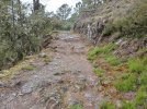
Tom injured his knee a week ago but is doing great. We initially thought we might not be able to do the Invierno, but things are looking up! So…. I am wondering about the surfaces on some of the steep downhill sections. We do fine on the uphills. But going down on loose rocky surfaces is a disaster for knees! So Any input you have on the following downhills would and whether they are loose and stoney would be great!
1. Castle Cornatel to Borennes
2. Las Medulas to Puente Domingo Florez
3. O Alberedos to A Rua
4. Bendillo toSoldon
5. The peak after San Clodio down to A Ponte
6. Castro cells to the Rio Saa
7. Diomondi to Belasar
8. Past Donelas to Ponte Ulla
Thanks for any input you can give us. L
1. Castle Cornatel to Borennes
2. Las Medulas to Puente Domingo Florez
3. O Alberedos to A Rua
4. Bendillo toSoldon
5. The peak after San Clodio down to A Ponte
6. Castro cells to the Rio Saa
7. Diomondi to Belasar
8. Past Donelas to Ponte Ulla
Thanks for any input you can give us. L


 . I can confirm what


 Right now we are feeling extremely optimistic about doing the Invierno! Thanks again! L