- Time of past OR future Camino
- Camino de Santiago, Norte (2016)
Camino Portuguese, Coastal (2018)
The recent death of a pilgrim along the Norte prompted me to retrace my own walk this September from La Arena to Castro Urdiales. Initially I remember it being a beautiful walk along an old railway that had been turned into a paved walking path far above the sea. There was a fence along the cliff and many people, not just pilgrims, were walking the path that day. The path eventually ended and as we followed the Camino markers we found ourselves at a roundabout. We could find no arrows or other such markers. I believe there were a couple of different roads off of the circle, one being a dirt road. We were considering taking the dirt path as it appeared to go back towards the sea. While we were standing there, a cyclist came along and we asked him which way to pick up the Camino. He pointed us to the highway and told us that was the best way for us to go. That road, N-634, was a two lane curvy highway with many blind curves and what appeared to be a steep drop to the sea on the other side of the guardrail. We hugged the left shoulder the entire time and at least once during that long stretch had to press our bodies against the rock wall on our left to avoid being hit by a car.
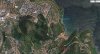
On another forum, and in response to the death of a pilgrim on that route, a person posted a google map picture of the Camino near Punta de Saltacaballos where the pilgrim's body was located. It appeared that a path actually ran along beside that highway just above the sea making me think that perhaps there was another option that we missed.
Did anyone else experience confusion at that same roundabout? Did anyone walk a trail parallel to N-634?
Thank you.
Last edited:


 I also remember the ripe figs we had for breakfast, harvested off a tree not on private property.