• For 2024 Pilgrims: €50,- donation = 1 year with no ads on the forum + 90% off any 2024 Guide. More here.
    (Discount code sent to you by Private Message after your donation)
  • ⚠️ Emergency contact in Spain - Dial 112 and AlertCops app. More on this here.

Search 69,459 Camino Questions

We walked from Cordoba to Merida in October

bjorgts

Active Member
Time of past OR future Camino
In Spain, France, Portugal, Germany since 2003
We walked from Cordoba to Merida between 6.10 and 15.10 this year. The weather was warm and sunny. Eight out of ten days we had more than 30°C, and the evenings were just perfect for wet and frozen Norwegians. Almost no water running anywhere. Since people ask about this route, and not so many have written about it, I will give a “report” here, but the report will be made in parts.

We walked from Granada to Cordoba in Spring 2010, so we were familiar with the route. Now that we have walked it all, I think we can conclude that we found the part from Granada to Cordoba the nicest. But Cordoba – Merida is also well worth walking. Some parts are really nice. The Cordoba- friends have a guide on this address: http://www.caminomozarabe.es/index.php? ... e&Itemid=1, with maps and Spanish description. We used this one and the German guide from Outdoor (Conrad Stein Verlag) “Mozarabischer Jacobsweg”. With those two, we found our way.

There are not many walkers, but people told us that the top season is in spring. When we walked in spring we met some other walkers. October was definitively not top season. We did not see a single walker for our ten days. Several times people told us that there was a man a day ahead, so we understood there there was someone there. We were also told that he had told them that he had seen nobody all the way from Granada.

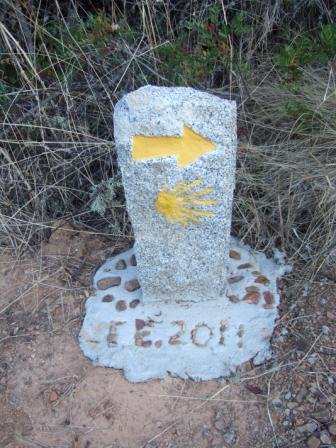
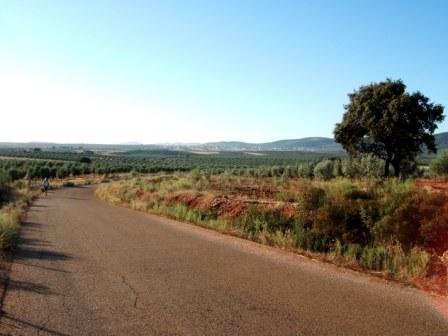
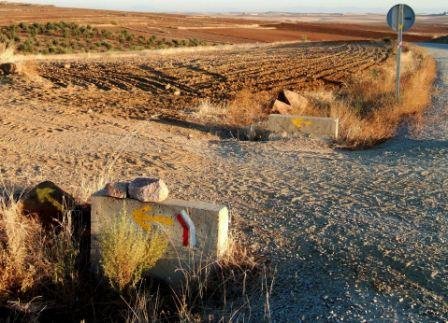
First day: Cordoba – Cerro Meriano, 18 km. We had some small problems fining our way out of Cordoba, but nothing that matters. The Cordoba- friends and the German guide are describing two different routs out of Cordoba. We followed the Cordoba-friends. The two routs are on each side of the main road N432. It seems both routs are marked. They meet after some kilometres when the one the German guide describes cross under the N432 to the east side of N432. We saw the yellow arrows pointing towards us in the tunnel. The rout the Cordoba-friends are describing, stayed on the east side all the way. The walk is quite steep up the last kilometres, so 18 km was enough for the first day with more than 30°C.

We followed the advice to do the walking this day without sacks and return to Cordoba when we reached Cerro Muriano. Cordoba is a very interesting city, and although we had been there in spring 2010, we wanted some more time there. So we had just enough time when we reached the village, to have a beer and a glass of cold Jugo de Naranjas natural (orangejuice) (perfect!) on the first restaurante, before we returned to Cordoba with the bus. You can find the Horarios here: http://www.caminomozarabe.es/images/sto ... 4d5401c997. The bus leaving Cerro Muriano 13:00 was perfect for us. There is a hostal in Cerro Muriano in the main street, so it is no problems staying there. We took the bus From Cordoba to Cerro Muriano next morning at 07:45.

Second day: Cerro Muriano – Villaharta, 21 km. The German guide promised us an “unspectacular day”, and in a way, that was right, because much of the day you walk parallel to the N432. But for long stretches we walked on paths a little bit away from N432, and then we think that we can not expect any better, when this main road is there after all. Half the way you can have a rest and visit a bar in El Vacar. (We had tomatos, queso and jamon! You are in jamon-land.) The lady at the bar/shop told us that she also had rooms for pilgrims.

Villaharta is a white, nice little village up in the hillside. There is a hostal which looked good (Bar Mirrasierra just when you enter the village), but the wife in the family was on hospital when we came there. When “mother” was not at work, the whole establishment was shut. There is a hostal down by the main road N432, El Cruce, so we stayed there. Next day (Villaharta – Alcarecejos) there is no way of splitting up the 38/39 km. For us that is just a too long distance, but how we solved that problem, I will tell you later. Bjørg
 
Ideal sleeping bag liner whether we want to add a thermal plus to our bag, or if we want to use it alone to sleep in shelters or hostels. Thanks to its mummy shape, it adapts perfectly to our body.

€46,-
thanks for this, Bjorg. I was in Cordoba the same time you were, and saw the Amigos´ waymark plaques, and it made me think.... hmmm! Interesting!
Keep up with sharing your notes here. I want to know more.

Reb.
 
Our third day:
There is no way of splitting the 38/39 km Villaharta – Alcaracejos. To do it all in one go, was not for us, so what to do then? I had studded the map, to find a point on the route where we could presumably find the yellow arrows, if we found someone who could drive us there. The point I had found, was where a road leaving N-502 down to the right crossed the camino after a kilometre (or may be a bit more?). This meant cutting off some kilometres too much, but we thought that this had to be the place. To find ourselves somewhere out in the wilderness, not finding any yellow arrows, would no be fun.

So, how to get there? A taxi was obvious, but in some way or another, the people helping us at Hostal La Cruce, could not get one. But one of the men at the bar that evening knew where the place was where we wanted to leave N-502, and he came the next morning and drove us there. If someone need to do what we did, here is a description: After may be 12-13 km (??) (we did not actually notice the distance) on first another main road and then on N-502, there is a road leaving to the left with a sign to Cortijo(or Finca) Val de Cruces. There we took the road leaving to the RIGHT for a km or so. There is a fence on your left side all the way here. Where the fence end, a small road/path leave to your left, and there are the yellow arrows clearly enough! We were happy. Here is a link to the map from the Cordoba-asociacion, where you can find the point where we drove right to the camino: http://www.caminomozarabe.es/index.php? ... &Itemid=18.

This etappe was said to be very beautiful. It was. You are out in nowhere, with a few Fincas, a lot of bushes, a rolling landscape and hundreds of small roads and paths crossing all over. We had a splendid day, and talked about how wonderful the flowering must be in April/May. We are quite sure that if we could choose in which end we should cut it, the last part of the day is less beautiful than the first; even though we have not sees the first part. But we could not find any practical way of having somebody (who?) finding us somewhere (where?) where we had never been.

If you are worrying about marking, forget that for this day! This landscape is really a place where you can get very lost! But this year the route for this day has been marked. (We suppose that the marking is the same on the first part of the day which we have not seen.) We agreed that may bee we have never walked on a better marked camino when we really needed it. Literary everywhere where you can hesitate or must choose between roads/paths there is a marking stone. (See the picture.) Fabulous and many thanks to those who have done the job!

In Alcaracejos we stayed at Hostal Tres Jotas for 28€. A cheap, good and very clean place.
Bjørg
 

Attachments

  • DSCF7360.JPG
    DSCF7360.JPG
    42.6 KB · Views: 1,933
A guide to speaking Spanish on the Camino - enrich your pilgrim experience.
Many thanks to all those who are sharing their experiences of walking the Mozarabe. At this stage my intention is still to walk Granada to Santiago early September 2012.I eagerly read all your posts. I suppose the main thing is to " step out in trust", to trust God, my fellow human beings, and my nearly 65 year old body, with its creaking joints !!

Sandra
 
Fourth day: Alcaracejos – Hinojosa del Duque (25km)
The landscape is quite flat this day – and the next, and the next – with fields of corn and grazing land with encinas (holm oak) spread all over; some grazing animals here and there, but now in October they were gathered for feeding. No green grass anywhere.

There are to places to stop during the day. In Villanueva del Duque there is said to be a bar, but it was to early for a stop, so we did not look for it. There is also sead to be a Museo del Camino Mozárabe in this village. In Fuente la Lancha after 11 km we had a rest on a bar. If you follow the camino, you will not come to the main street where the bar(s?) are. Then you must turn right when you come to the church or a little bit later. When you come to Hinojosa, you first meet an industrial area, and there is a restaurante/bar, where we had a stop. If you are going to sleep here, you can turn right by the first little park, to the main street, and there you will find Hostal Cazador a little bit up (or down?) this main street. It does not cost much, not very friendly people, but a good place to stay. We just slept there and stayed in the city centre till Menu del Dia. This we had on Restaurante Finojosa some 100 meters or so up the main street from the Hostal. Here we had a really good Menu. I think we payed 10€.

We found Hinojosa del Duque to be one of several small industrial villages in this area. Mining has been important since the romans, and all sorts of industy seems to bee important here. So for some days now you will stay in villages/cities which is not the most exotic you have seen, but some of them have very nice parts or centres. Hinojosa is one of them. There is a cathedral in the centre, and the plaza around it is a very good place to spend the afternoon and evening when the weather is good. (See the picture.) We stayed there all evening.

I think I have read somewhere that there are plans for an albergue de pelegrinos in Hinojosa.
 

Attachments

  • DSCF7411 (2).jpg
    DSCF7411 (2).jpg
    21.5 KB · Views: 1,810
Ideal pocket guides for during & after your Camino. Each weighs only 1.4 oz (40g)!
Our fifth day: Hinojosa del Duque – Monterrubio (33 km). This day will bring you from Andalusia to Extremadura. There are no places in between to stay for the night or for buying anything. We started early because of the heat and the 33 km. Most of the day you can walk on small roads and farmland-tracks without asphalt– nice walk; farmland with encinas all the way. You cross two Arroyos after 4 and 8 km. Since we walked in October, I know nothing about water! On another time of the year, by the second one you may have to walk downstream 50-100 m to find some rocks for passing.

This day there are two options. After may be 11-12 km (not quite sure of the distance!) you reach an asphalt road some 500 m after having passed a farm (with barking dogs). At this crossing there is an old yellow arrow pointing right along the road. This is for “bicicletas” AND walkers when there are much water in the rivers! If the period is dry and have been dry for a while, you can cross over the asphalt road and continue. This route is also marked. You cross the asphalt road ones more, so you will have one more chance to choose the other option before reaching the Rio Zujar. This is a real Rio, but even this one was almost without water when we walked there. But we saw on the vegetation that this river can be quite big. See the photo of flooding rests quite high up in the trees.

If you choose the roadwalking, the warning is: This will give you roadwalking for the rest of the day. BUT: If the Rio is really a Rio at the time you walk, you can not cross it. If the period is dry and have been dry for a while, choose the route with small roads without asphalt and farmtracks. It is a really nice walk, may be a kilometre or two longer. When we crossed the river, I think we saw the road up behind us, so I thought that if we had walked that fare on the tracks and could not cross the river, we would have been able to find our way to the road and the bridge.

The trackroute and the roadroute meet at Eremita de Nuestra Señora de Gracia de las Alcantarillas. Take a rest. You have 8 km of roadwalking ahead until you reach Monterrubio!

Monterrubio also have a nice plaza by an old church. There is a Hostal (Vaticano) and a hotel there. When we came there, the Hostal was “completo” with workers, and at the hotel, there were nobody. (They came later.) So we ended up at what is the nearest you come to Albergues at this route: Two mattresses at the floor in the meetingroom of the Parroquia. Nice, helpful and friendly people. Good Menu at the Hostal.
 

Attachments

  • DSCF7444(2).JPG
    DSCF7444(2).JPG
    19.8 KB · Views: 1,722
  • DSCF7438(2).JPG
    DSCF7438(2).JPG
    33.7 KB · Views: 1,711
Thanks so much for this, bjorts. Added to your report last year on the route from Granada to Cordoba, it looks like we now have the makings of an English guide to the route from Granada to Merida. It's great to have all this help for a relatively unknown stretch. I'm hoping to walk there in a year or two. Buen camino, Laurie
 
Our sixth day: Monterubio – Castuera 18 km.
This is a short walk, most of the way on a tarmacked road with almost no traffic, through
olive groves and encinas, and with nice landscape. This is a short walk, but there are only this possibility to diverse the stretch to Campanario which would have been 41 km. After some kilometres, you see a village up in the hillside on your right hand side. You will see it for many kilometres, and may think it is Castuera, but it is not (Benquerencia de la Serrena). Although this was our shortest walk, we were very tired at the end, because of the heat. So the last kilometre uphill seemed very long.

This is a nice little village with some interesting things to do in the evening. We stayed at Hotel Los Naranjas at the top. I have read somewhere that there are plans for an albergue here. Los Naranjas is a good place to stay. Two places to go after a rest: Museo del Turrón and Centro de Interpretación de La Serena. We went to both, but will recomend Centro de Interpretacion if you understand a little bit spanish. Here you can learn about the landscape you walk through those days. After this visit, we saw the landscape with more understanding. There was an exelent guide there. Although I know very little spanish I understood a lot because she spoke very slowly and distinct, and with great engagement.
 

Attachments

  • DSCF7456 (2).jpg
    DSCF7456 (2).jpg
    21.3 KB · Views: 1,641
New Original Camino Gear Designed Especially with The Modern Peregrino In Mind!
Our seventh day: Castuera - Campanario (20+2 km). This is an easy walk, with few places where you can take wrong directions. Most of the way you follow roads and paths without tarmac. After some 4-5 km, you walk parallel to the railway, when you have to cross a small river. As I have said before, we walked in an extremely dry season, but still there were some water there. This was absolutely no problem for us, but we saw that there had been problems for other walkers. We saw the marks where the walkers had climbed up to the railway on one side, passed the river on the railway bridge, and then down again on the other side. So if you see this river on the map and wonder if you can pass, you can use the railway bridge. I do nt know if this is really safe and it is not for those who do not like heights! The landscape change from oaks and farmland to more olives and open plains.

If you are just passing, you do not have to go into the centre of Campanario, but I will recommend that you do. Campanario is another of the many industrial places on this route, but also here you will find a very nice plaza around the church. This is a good place to take a rest. You will find no place to sleep here. On the plaza around the church there are good bars. If you have arrived in time for a comida, you follow the yellow arrows some hundred meters further to the left (on Avenida de la Constitucion) to a petrol station on your left. Here the camino crosses the main road and there are restaurants. The camino continue straight on out of town on EX115.

Where to sleep: 2 km out of town there is an albergue! (Albergue Rural de Estacion). I can recommend it. Take contact on beforehand to be sure there are somebody there. I think the new number is 695 669 474. (In the German guidebook it was said to be 619 653 760.) In an earlier railway station there are plenty of rooms and beds; new, clean, nice, and with a veranda. In a nearby building is a bar which was open in the evening and where we could get a meal. Me and my husband had the whole house on our own.
 

Attachments

  • DSCF7490-Kopi.JPG
    DSCF7490-Kopi.JPG
    26.2 KB · Views: 1,545
Our eights day: Campanario – Don Benito (24km?)
You retrace your steps some 500meters and turn left on a road without tarmac, as Wombat says. Since we knew from the evening before where to go, we started at half past seven in absolute dark. The days were so warm that we tried to get out early, but the problem is that in the middle of October, that is not very early, if you have to wait for the light. On the other hand, it is a very nice experience to walk out in the dark and see the light slowly coming.

No problem finding our way to Magacela. You see it in the hillside almost from the beginning, and the marking is OK. I hoped for a rest on a bar there, but what a disappointment when the yellow arrows pointed out the way to the left, and I realised that we were walking around the hill with the village! If you want to do the same, follow the description of Wombat. We did too, because we did not have the courage to leave the yellow arrows. Now, having done that, I know better. This is what you should do if you want to visit the village: When you come near, you will see high up in the hillside on the left side of the village, a small road going around the hilltop to the left. So if you go up into the village, just find this road out to the left near the top, and you will end up a bit down on the back side, where you will find the yellow arrows again. It seemed to be white and red signs which we could have followed up in the village and on the road to the left, because we met them on the other side. This little village is so special, that I would have climbed the hill, if I had known that I would find the yellow arrows on the back side of the hill.

The moors dominated this territory with difencive enclaves. Walking from Granda, we have seen a lot, and Magacela was one of them. You pass the prehistoric sites La Mata some kilometers earlier.

La Haba is just on the right place if you have struggled with the sun throughout the day. You can find both bar and supermerkado there. The supermerkado is a little bit away from the Plaza, but no problem finding it, when we asked. Then it is no shade until Don Benito.

If you are going to Hostal Galicia in Don Benito, and need help to find it, ask for Plaza de España. Take Calle the Arroyazo to the left in the far end of the Plaza (if you come in from the La-Haba-side.) We had a nice stay there, and most of all we had a good Menu outside in the late October summer night, thinking of the cold and rain back home, which were coming nearer and nearer each day.

The Hostal do not serve breakfast early, but you can find a bar (or may be it was a panaderia?) in the same street, some meters nearer to Plaza España. We had one of our best breakfasts there.
 

Attachments

  • DSCF7503-liten.JPG
    DSCF7503-liten.JPG
    43.8 KB · Views: 1,450
Our ninth day: Don Benito – San Pedro de Merida (How many kilometres? Many!...)

Our walk this day became longer than we had planned, but we found our choices good after all. The walk from Don Benito to Medellin is nice, and the view of the castle on the hilltop is great. Medellin is a nice little town. I had hoped to stay over night there. Herman Cortes was born here, the castle would be nice to visit and there is a hostal at the far end of the town, just before you cross the bridge.

Further on you have a choice between two routes. Wombat has described the route to Santa Amalia parallel to the EX-206. Then you get many kilometres on the shoulder of N-430, as Wombat has described. That was what we wanted most of all to avoid, so we choose the route to Yelbes. To get there, you just follow the road to Yelbes straight on where the route to Santa Amalia turns right. When you come to Yelbes, you turn right into a street opposite of the church. At the end of that street, where the houses end too, you get to a T-junction. (I think you also cross a water canal here?) Here you turn left. After some meters (100-200?) you turn right onto a path/small road. Everything is flat! Follow this path/small road for some distance, until you cross over an irrigation canal and meet a new T-junction. Here the marking is not good! We found a stone with a yellow arrow which was thrown away a little further on. But you turn right when you have crossed the bridge over the irrigation canal and follow parallel to the canal on its left side till you come to a new T-junction, but this time the T-road has tarmac. Turn left and follow this road straight on until you reach the N430 near the bridge over Rio Burdalo. And when you cross that bridge, with the cars passing near you in high speed, you will be happy that you did not have to walk like that for 7-8 km!

After 2 km on the shoulder of this road, you turn left to Torrefresneda. Here is a nice bar, where we had a rest. We had hoped to take a bus or a taxi from here to San Pedro de Merida. When we asked in the bar, they said that a bus was passing through between half past three and four. At half past four, we realised that no bus would come that way. We asked for a taxi, but they could not help us. Nothing to do but start walking another 10 km. You walk parallel to the A-road on the security-road. I t is not a great walk, but almost no cars, and much better than the shoulder of N430.

In San Padro de Merida, you go through the town, up near the main roads. There you will find a couple of hostals.
 
The 2024 Camino guides will be coming out little by little. Here is a collection of the ones that are out so far.
Hi Bjordts,

Thanks for your posts. Every piece of information is excitedly read. I feel blessed to have been able to read the posts from you and Wombat. Thank you for your willingness to share your experience with others. Maybe one day I will have the experience to share !!!

Sandra.
 
Last leg, San Pedro de Merida – Merida.
A last report from me about our walk from Cordoba to Merida.

When you leave San Pedro de Merida, you return where you came from the day before, and turn into Calle Mayor and Avenida de Merida on leaving town. Follow the service-road along the motor-way to Trujilanos. Go through the town to the bridge over the motorway at the outskirt. Old guides tell you to go straight on here alongside the motor-way, but do as Wombat says: Cross over the road-bridge to the other side. Here you turn backwards for some meters (50m?) on another road. But then you turn right down a small road between olive-trees. It is marked. (You see it from the road-bridge.) Then, just follow this nice road all the way to Merida.

Have a nice walk on Camino Mozarabe! I will start in Cadiz in a couple of weeks.

Bjorg
 
Hi ! I have been walking the Mozarabe in sections. I did Granada to Alcalá, then to Cordoba, and next to Hinojosa. I just started yet again from there and right now in Campanario staying in the Albergue in the old station. Some news, Hinojosa and Castuera now have brand new albergues. Great new facilities so good news for peregrinos. Last time I walked this Camino I met José, a camino vereran, like 7 times. He told me about the route via Trujillo to Placencia. It sounds very interesting. Takes off 3 days off the Santiago destination. I must admit reading the route descriptions there seems a lot of tarmac roads on the last few days to Merida. My body doesnt like these ways! What are others experience of the last stages to Merida, via Don Benito etc? In any case, Buen Camino a todos!
 
St James' Way - Self-guided 4-7 day Walking Packages, Reading to Southampton, 110 kms
Is there any important difference between the Santa Amalia and Yelbes routes except the distance?
 
From what I can read, the river via Yelbes can be high at certain times of the year. You have to cross that. It just poured down here so I think its going to be high. That means some tarmac walking on the Santa Amalia route for me.
 
There is indeed an unofficial direct route West from Yelbes crossing the river, described in the blog by Magwood. However the official Yelbes route turns North to take the same road bridge as the Santa Amalia route, so I am still wondering.
 
The one from Galicia (the round) and the one from Castilla & Leon. Individually numbered and made by the same people that make the ones you see on your walk.

❓How to ask a question

How to post a new question on the Camino Forum.

Forum Rules

Forum Rules

Camino Updates on YouTube

Camino Conversations

Most downloaded Resources

This site is run by Ivar at

in Santiago de Compostela.
This site participates in the Amazon Affiliate program, designed to provide a means for Ivar to earn fees by linking to Amazon
Official Camino Passport (Credential) | 2024 Camino Guides
Back
Top