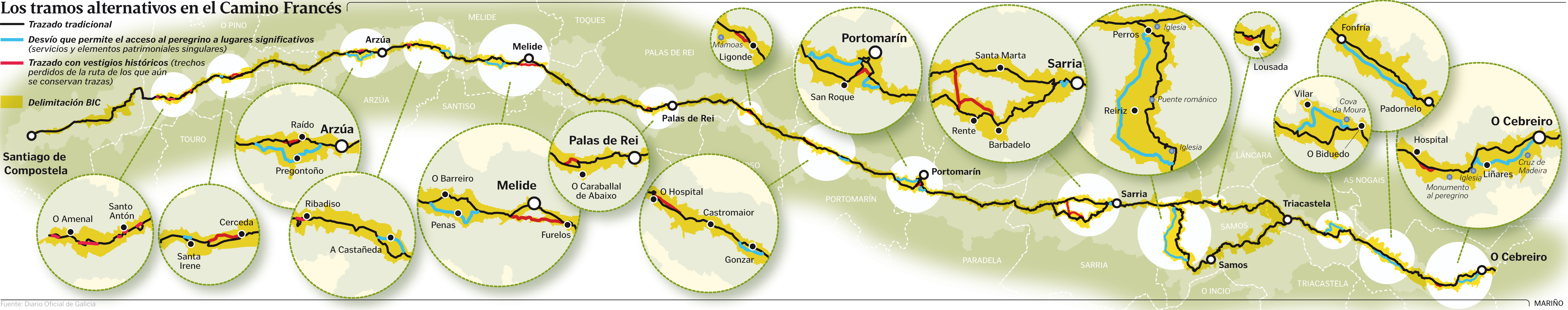
- Time of past OR future Camino
- Enjoying the camino since 2009
I have just come back from a walk from Rabanal to Santiago, and noticed some new route choices along the way - some of them worrying. In particular the new signs in O Cebreiro, which seems to indicate that the recommended route to follow is to walk on the road (!) and that the lovely walk through the woods, starting at the municipal albergue at the end of town, is a 'complementario' route, hinting that it is a detour or not the 'right' one. I have walked this part of the Francés many times and always walked through the woods, apart from once when it was deep in snow and we walked along the road. I really cannot understand how the road could be recommended apart from when the wood trails are covered in snow! In fact it seems dangerous to lead pilgrims onto the twisty road, especially early in the morning. If you do take this trail, make sure you are wearing reflective clothing!
If anyone is in or near O Cebreiro now, it would be great if you could confirm or even take a pic of the new signs pointing to the road (carretera) as the recommended route.
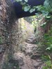
I also walked the new, steep route down to Portomarín once and can't understand why that would be the 'real' route - in or after rain that would be treacherous, so I am happy to see that the marker now points both to the 'new' (but historic?) and the 'old' route. You get to a road crossing the smaller road you are on, where if there is a concrete marker pointing both to the right and left - see photo below. I would definitely recommend turning right and following the smaller tarmac road down to the river and the bridge.
There are other places too where what I know as the camino is now a 'complementario', though it's not always clear (as when leaving Portomarín) where the new one is.
Does anybody know why these parts of the trails have become 'complementario' or why pilgrims are recommended to walk on the road? @Rebekah Scott? @ivar? @natefaith?
I am pretty sure this is the marker before Portomarín, claiming that the trail to the left, the steep slope down between two stone walls, is the more historically correct, while the other, to the right, is a 'secundario' (but in my opinion by far the safest and easiest).

If anyone is in or near O Cebreiro now, it would be great if you could confirm or even take a pic of the new signs pointing to the road (carretera) as the recommended route.
I also walked the new, steep route down to Portomarín once and can't understand why that would be the 'real' route - in or after rain that would be treacherous, so I am happy to see that the marker now points both to the 'new' (but historic?) and the 'old' route. You get to a road crossing the smaller road you are on, where if there is a concrete marker pointing both to the right and left - see photo below. I would definitely recommend turning right and following the smaller tarmac road down to the river and the bridge.
There are other places too where what I know as the camino is now a 'complementario', though it's not always clear (as when leaving Portomarín) where the new one is.
Does anybody know why these parts of the trails have become 'complementario' or why pilgrims are recommended to walk on the road? @Rebekah Scott? @ivar? @natefaith?
I am pretty sure this is the marker before Portomarín, claiming that the trail to the left, the steep slope down between two stone walls, is the more historically correct, while the other, to the right, is a 'secundario' (but in my opinion by far the safest and easiest).
Last edited:


")