• ⚠️ Emergency contact in Spain - Dial 112 and AlertCops app. More on this here.
  • Remove ads on the forum by becoming a donating member. More here.
  • 20% off everything Altus the next few days at the Camino Forum Store. More here. (Discount taken at check out)
  • Get your Camino Frances Guidebook here.

Search 69,459 Camino Questions

One Napoleon but two variants......

blind fool

Member
Time of past OR future Camino
October 2019
hi there,

having cycled the Camino already I'm 'familiar' with the Napolean route using the surfaced road from Orisson to the 'Peak' where you venture off road to the right where there is a memorial.
However as I'm sure many of you will know there is a dirt track off to the left which while steep etc does create a 'short cut' and does away with one of the 'switch backs' on the road.
Just trying to understand distances and how much distance might be saved - I appreciate it'll be considerably steeper etc but wonder whether its worth the effort?

buen camino :)
 
Get a spanish phone number with Airalo. eSim, so no physical SIM card. Easy to use app to add more funds if needed.
I've always biked the road into Roncesvalles and it it is exhilarating.
 
Ideal pocket guides for during and after your Camino. Each weighs just 40g (1.4 oz).
thank you for your replies - please forgive me however.
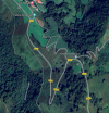
I've just checked on the map and the 'diversion' I was referring to is just before you arrive at Orrison - just wondering if the zig zag dirt track is worth the effort?
1715096550038.png
 
If you do take a diversion to your best calculations what us the time difference?
IMHO anything 15-20 mins is not worth pondering about hence again IMHO it's mot about the distance
As I understand the diversion is longer but safer. My safety worth the extra time
 
€2,-/day will present your project to thousands of visitors each day. All interested in the Camino de Santiago.
the 'diversion' I was referring to is just before you arrive at Orrison - just wondering if the zig zag dirt track is worth the effort?
View attachment 169715
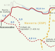
I have no idea whether any cyclists ride up the zig zag footpath and what this would do for erosion. Here is a proper map, perhaps it can help with your decision-making?

SJPP to Orisson.jpg
 
thank you very much.
I'm inclined to think there's nothing to be gained (other than hard work and erosion).
thanks again.
 
would I be right in thinking you're referring to the Valcarlos route?
glad you enjoyed. 👍
Sorry, I completely misunderstood your post. I was referring to the road from Col du Lepoeder down into Roncesvalles avoiding the short cut through the forest. And no, I didn’t take the path short cut before Orisson.
 
Prepare for your next Camino on California's Santa Catalina Island, Oct 27 to Nov 2
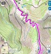
I have no idea whether any cyclists ride up the zig zag footpath and what this would do for erosion. Here is a proper map, perhaps it can help with your decision-making?

View attachment 169729
I saw walking pilgrims hike up that zigzag while I cycled the D428 - it's crazy steep! Even if you have incredible legs you'll (maybe) loose traction
 
Sorry, I completely misunderstood your post. I was referring to the road from Col du Lepoeder down into Roncesvalles avoiding the short cut through the forest. And no, I didn’t take the path short cut before Orisson.
as they say - my bad. I didn't explain very well 👍
 
Ideal sleeping bag liner whether we want to add a thermal plus to our bag, or if we want to use it alone to sleep in shelters or hostels. Thanks to its mummy shape, it adapts perfectly to our body.

€46,-
hi there,

having cycled the Camino already I'm 'familiar' with the Napolean route using the surfaced road from Orisson to the 'Peak' where you venture off road to the right where there is a memorial.
However as I'm sure many of you will know there is a dirt track off to the left which while steep etc does create a 'short cut' and does away with one of the 'switch backs' on the road.
Just trying to understand distances and how much distance might be saved - I appreciate it'll be considerably steeper etc but wonder whether its worth the effort?

buen camino :)
I have walked both and my opinion is the road to the right is best. After the climb from SJPP you are not 100% and it’s easy to slip/fall on left while the right is about 1 k longer it’s much safer
 
Transport luggage-passengers.
From airports to SJPP
Luggage from SJPP to Roncevalles

Most read last week in this forum

A local Navarra website has reported the death of a 61 year old German peregrina this morning in Zuriain. The cause appears to have been cardiac arrest. The third death of a pilgrim in Navarra in...
We’re currently on the Frances. We’re walking from SJPDP. We’re looking at our projected dates for Sarria to Santiago. When we try to find lodging it all looks sold out on booking.com. What...
I just got an email that the train from Bayonne to St Jean tonight is canceled. Anyone else see this?
A few km before Portomaran, a huge swarm of wasps swooped down on a pilgrim. Thankfully, he wasn’t stung. He said it looked like a flock of sparrows that swooped down and he thought they were...
Here is a pic from 2016, I love the simplicity of the sketch map and directions "1 km climb up, 5km flat, 5km down". I wonder how the prices are now?
Reposted from Wise Pilgrim comments, was hiking with this pilgrim. Don’t follow app,go just a bit further past to well marked turn, not the one with spray painted arrow on stop sign:

❓How to ask a question

How to post a new question on the Camino Forum.

Forum Rules

Forum Rules

Camino Updates on YouTube

Camino Conversations

Most downloaded Resources

This site is run by Ivar at

in Santiago de Compostela.
This site participates in the Amazon Affiliate program, designed to provide a means for Ivar to earn fees by linking to Amazon
Official Camino Passport (Credential) | 2024 Camino Guides
Back
Top