• Remove ads on the forum by becoming a donating member. More here.
  • 20% off everything Altus the next few days at the Camino Forum Store. More here. (Discount taken at check out)

Search 69,459 Camino Questions

Re-educating myself with Wikiloc

peregrina2000

Moderator
Staff member
I haven’t used Wikiloc for a year, except for one recent test ride on my bike, but I hope to be using it soon on a camino. I am imagining myself in Spain, with no wifi and no data and having downloaded maps of Spain for offline use. In the past, I have sent anxious messages for help to my forum wikiloc angels, but I would like to do all I can to avoid that situation this year!

Can someone evaluate what I’ve written here and tell me if these steps will make me a happy, successful wikiloc user? (I will come back and edit this post if I have made mistakes or omitted important steps).

Before leaving home:
1. Use the “list” function to make lists of tracks that I have found on wikiloc. One list per camino for me.

2. Save those tracks. Be careful not to think that putting a track on a list means that it is saved (thank you, @islandwalker). Unless it is saved, I cannot follow it. To save a track, click on the track. When the track and all its info is on my phone screen, scroll down and make sure that I toggle on the “save trail.”

On camino:
1. Pull up the saved trail that I want to follow that day.

2. Click on “start navigation.”

3. As I walk, if I want to take pictures that will make a “waypoint” on my wikiloc trail (so that I can later see exactly where some particular thing is located, or if I just want to let others who may use the tracks see what it looks like) just use the camera icon at the bottom right of my phone. The camera comes up, takes a picture, and then I can decide whether to use it or not. I have to make sure that my photos and my wikiloc camera are “synced” so that all of the pictures I take through wikiloc will automatically be on my phone camera roll.

4. At the end of the day’s walk, click on the red button on the lower left and then I can either discard the tracks or save them. The defaul will be to save them publicly, so if I want them to be private, I have to switch the setting.

One question for anyone who has had the patience to read this far. Will the offline maps pop up automatically when I am offline, or do I have to arrange that before I go offline and start walking without data or wifi?

What am I forgetting? Mil gracias, Laurie
 
New Original Camino Gear Designed Especially with The Modern Peregrino In Mind!
I've got a few things going on so I can't take time to provide detail for a few days but one easy thing that comes to mind is that I remember Wikiloc asking when you are following a track whether you want to record also. Of course you do Laurie as you will find things to visit off the track that the track's originator didn't think of.
 
Here is something that I consider a Wikiloc bug. If you are in airplane mode when you start up the Wikiloc app (like you may be when you start in the morning) you will see a cursor pointing out your location but unhelpfully it will be on a blank map, even if you had already downloaded a map of your region. What you have to do is select the layers icon, looks like three sheets of paper, and then select the downloaded map from the list presented. The rest of the base maps in the list can be really fancy, e.g. satellite view, but if you pick any of them it will require internet access and on the trail that will require cellular data be running.

Really easy to test this as you must already have a map of your state downloaded already.
 
Get a spanish phone number with Airalo. eSim, so no physical SIM card. Easy to use app to add more funds if needed.
I've got a few things going on so I can't take time to provide detail for a few days but one easy thing that comes to mind is that I remember Wikiloc asking when you are following a track whether you want to record also. Of course you do Laurie as you will find things to visit off the track that the track's originator didn't think of.
Hmmm, I thought that you had to record the trail when you “navigated” it (their word). No rush, I’m not leaving till Tuesday. :D
 
@peregrina2000, adding to what Rick says above, I think your list is really complete. I believe the downloaded map always popped up automatically for us, but it is good to know the step Rick mentioned with the "Layers" icon just in case. One addition: we always put our phones in airplane mode and low power mode before we started off for the day in order to conserve the battery. This works on our iPhones, but did not work on our daughter's android phone. She could use airplane mode, but if she put low power mode on, she got a blank screen on Wikiloc.
 
Here is something that I consider a Wikiloc bug. If you are in airplane mode when you start up the Wikiloc app (like you may be when you start in the morning) you will see a cursor pointing out your location but unhelpfully it will be on a blank map, even if you had already downloaded a map of your region. What you have to do is select the layers icon, looks like three sheets of paper, and then select the downloaded map from the list presented. The rest of the base maps in the list can be really fancy, e.g. satellite view, but if you pick any of them it will require internet access and on the trail that will require cellular data be running.

Really easy to test this as you must already have a map of your state downloaded already.
Thanks much for this tip. I do have my state downloaded, and it popped right up when I clicked “record trail.” But that may have been because I was riding around my home area recently to experiment with the app. In any case, I will remember that the layers icon is where to go if I get a blank screen. More accurately, what I will certainly remember is that I can come back to this thread if I get a blank screen, and will then be reminded to go to the layers icon!

One thing I did notice though, which is not an issue for me but may be for others, is that “your trails” seems to work the same as “Lists”. That means that if for some reason I wanted to follow some of the tracks that I had previously recorded, I would need to pull up that track, scroll down to the bottom and toggle “save track.”
 
Ideal sleeping bag liner whether we want to add a thermal plus to our bag, or if we want to use it alone to sleep in shelters or hostels. Thanks to its mummy shape, it adapts perfectly to our body.

€46,-
I was not able to reproduce the problem with the blank map. I've seen it pop up unexpectedly before. I started Wikiloc this morning with Wifi and my previously downloaded basemap appeared (I can't tell if from Wifi or download). I blew away the Wikiloc app, turned on airplane mode and started Wikiloc again. No map until I forced it. I reported the problem only after this test. Based on the reports I tried reproducing the problem a few more times but I was unable too. Anyway we all know now how to fix it.
 
I haven’t used Wikiloc for a year, except for one recent test ride on my bike, but I hope to be using it soon on a camino. I am imagining myself in Spain, with no wifi and no data and having downloaded maps of Spain for offline use. In the past, I have sent anxious messages for help to my forum wikiloc angels, but I would like to do all I can to avoid that situation this year!

Can someone evaluate what I’ve written here and tell me if these steps will make me a happy, successful wikiloc user? (I will come back and edit this post if I have made mistakes or omitted important steps).

Before leaving home:
1. Use the “list” function to make lists of tracks that I have found on wikiloc. One list per camino for me.

2. Save those tracks. Be careful not to think that putting a track on a list means that it is saved (thank you, @islandwalker). Unless it is saved, I cannot follow it. To save a track, click on the track. When the track and all its info is on my phone screen, scroll down and make sure that I toggle on the “save trail.”

On camino:
1. Pull up the saved trail that I want to follow that day.

2. Click on “start navigation.”

3. As I walk, if I want to take pictures that will make a “waypoint” on my wikiloc trail (so that I can later see exactly where some particular thing is located, or if I just want to let others who may use the tracks see what it looks like) just use the camera icon at the bottom right of my phone. The camera comes up, takes a picture, and then I can decide whether to use it or not. I have to make sure that my photos and my wikiloc camera are “synced” so that all of the pictures I take through wikiloc will automatically be on my phone camera roll.

4. At the end of the day’s walk, click on the red button on the lower left and then I can either discard the tracks or save them. The defaul will be to save them publicly, so if I want them to be private, I have to switch the setting.

One question for anyone who has had the patience to read this far. Will the offline maps pop up automatically when I am offline, or do I have to arrange that before I go offline and start walking without data or wifi?

What am I forgetting? Mil gracias, Laurie
Perfect timing for this great summary as I will using Wikiloc for the first time mid Sept!

Thanks Guy
 
I added someone else's track in a park that Peg and I often take our daily walk. I tried to go through your steps to check them but I had let my premium membership lapse. Things didn't work like I expected them. I'm going to make comments on your steps without actually testing them.

For "Before going" everything looks right. I couldn't create a new list because I need premium to do that. I added the track to the "want to go" list that already exisited. I couldn't actually get to follow the track (so that I would get beeped if I didn't) but I saw the track on the map. Where I did something that I remembered would do the follow I would get a popup trying to upgrade me to premium. Probably not until January. Anyway those steps look okay. I am assuming that you plan to add a list with a name like "Camino Frances 2022" and load that with, say, 33 tracks.

For step 3 of "On the camino" this is what I remember. Clicking the pennant and camera icon allows you to take a picture. In my experience it requires you to. Take picture and click the checkmark if you like it. [Something else] if you don't and take another and so on. Once okay you get to fill in info about the waypoint and/or picture. But I don't see how to get to that point without a picture.

Another thing about pictures that I see is that Wikiloc creates a directory/folder for itself for your pictures if it does not already exist. On my Android it is in the Pictures/wikiloc directory and photos show up there with the name format of yyyy-mm-dd_hh-mm-ss.jpg. My Google Photos app will show these and I can set things up so photos in the directory get backed up into the cloud. I can also copy, move, delete or rename them. Anything is game once I have uploaded my track to the Wikiloc website.

I typically upload my tracks to Wikiloc right away even without WiFi as track data doesn't take up much space and even with my network provider's expensive data plan each picture is in the range of 2 cents apiece to upload.

For step 4 remember that the red square allows you to do two things, pause or terminate the session. Say you are recording a new track never done by anyone before so you want to show others how to get from the start to the finish. You stop for lunch and amazingly run into a cousin that you want to catch up with but your cousin wants to go shopping all over town. You have plenty of time so you pause Wikiloc and go shopping. You return to the lunch stop, hit resume and continue your walk. Wikiloc won't show the spaghetti walk you took with your cousin when you upload the track to the Wikiloc website. You are familiar with the other red square option which allows you to upload the track, delete it without doing annything or hold it in a draft state.

Again, when done, to prevent me from losing anything, I typically upload right away. I usually have a setting say to do no uploads or downloads automatically over cellular. If Wifi is not working Wikiloc asks me if I want to upload over cellular. I say yes and now it isn't an automatic use of cellular and the upload happens

I'm done with this post now.
 
Last edited:
Technical backpack for day trips with backpack cover and internal compartment for the hydration bladder. Ideal daypack for excursions where we need a medium capacity backpack. The back with Air Flow System creates large air channels that will keep our back as cool as possible.

€83,-
And now I'm posting again to clear something up about that red square. There is an ISO standard that a square means stop and two parallel vertical lines mean pause. Wikiloc's red square is actually a pause. If you hit it you then see a green "Resume" and a red "Finish". I guess they did it that way because everyone wants to finish and only some want to pause. Still, rather than only the red square button, I would have put in both a pause button and stop button.
 
A little issue this morning as I brush up on my Wikiloc knowledge 😂… will be first time! I have downloaded Primitivo and Salvador trails and maps for off line use.

Testing on a trail I recorded at home…volume as high as it can go…airplane mode…battery low power…Bluetooth off. Can follow trail fine…get messages if I have off trail, lost trail, back on trail BUT no sound whatsoever. So that wouldn’t be too good as I won’t be walking with phone in hand.

Gone to Settings both General and Wikiloc specific notifications and can’t find anything wrong . IPhone 13 IOS 15.6.1…any ideas much appreciated!

Guy
 
Get a spanish phone number with Airalo. eSim, so no physical SIM card. Easy to use app to add more funds if needed.
BUT no sound whatsoever. So that wouldn’t be too good as I won’t be walking with phone in hand.

Gone to Settings both General and Wikiloc specific notifications and can’t find anything wrong . IPhone 13 IOS 15.6.1…any ideas much appreciated!

Guy
Oh, that sounds frustrating. You said you checked that notifications are enabled?
Settings > Apps & Notifications > Wikiloc > Notifications

Perhaps if you turn low power mode off?
 
Thanks…unfortunately no sucess…have sent Wikiloc a message. I have have sounds before however it’s been a number of weeks since I used Wikilocs…concerned that an Apple update may have caused this!

I would be so happy to admit to having simply missed something obvious 🙄
 
The 2024 Camino guides will be coming out little by little. Here is a collection of the ones that are out so far.
OMG 🤣👍😂 So sorry to have troubled you…I have been happily married for 43 years sooo…I just turned to Dawn my wife and said this is frustrating.

« Have you flipped your switch on the side to silent mode off? ». Right away I thought yes and oh oh I’m the same breath! Of course that was my problem.

Thankfully Dawn was not surprised at all…problem solved…so sorry again for this ridiculous faux pas.

If interested in more of this kind of stuff from me you might want to take a peek at my blog www.caminolongwalk.blogspot.com…I will be blogging next two walks.

Muchas Gracias ☺️

Guy
 
Last edited:
« Have you flipped your switch on the side to silent mode off? ». Right away I thought yes and oh oh I’m the same breath! Of course that was my problem.
Yay! The problem with the silent switch has happened to me also, so I am glad for the reminder. Thanks for posting the URL for your blog. I’ll be watching!
 
Love your story @GuyA. I have been using it for five days walking and it’s working like a charm. It’s so great to just put the phone away and not worry. I have been walking through the Cañadas, which are about 75 m wide. The location device is so accurate it beeped when I decided to take a path a little over on one side for a while. It also beeped once this morning when I was sure I was going right. When I took out my phone and looked, it must have been that the person whose tracks I was following popped off the trail for a bathroom break because his track went behind a big tree.

Hope you have the same great experience as I’m having. When are you leaving?
 
New Original Camino Gear Designed Especially with The Modern Peregrino In Mind!
Love your story @GuyA. I have been using it for five days walking and it’s working like a charm. It’s so great to just put the phone away and not worry. I have been walking through the Cañadas, which are about 75 m wide. The location device is so accurate it beeped when I decided to take a path a little over on one side for a while. It also beeped once this morning when I was sure I was going right. When I took out my phone and looked, it must have been that the person whose tracks I was following popped off the trail for a bathroom break because his track went behind a big tree.

Hope you have the same great experience as I’m having. When are you leaving?
Thanks Laurie…leave on the 14th Wednesday …arrive on 15th…on to Oviedo and start walking on16th the Primitivo. Then once complete make my way to Leon on the 29th and walk the Salvador for 5 days.

I know this is backwards 😂 but a small price to pay to meet up with two separate walking friends from 2013 & 2014.

Wrote in my blog about the risks of pre-booking which we have done and something happening early…so fingers crossed 🤞. I can “feel it in my bones” that all will work out and if not Plan B or Plan C 😂

Enjoy your Camino…assume it is a route less travelled as you are quite adventurous!

Guy
 
A little issue this morning as I brush up on my Wikiloc knowledge 😂… will be first time! I have downloaded Primitivo and Salvador trails and maps for off line use.

Testing on a trail I recorded at home…volume as high as it can go…airplane mode…battery low power…Bluetooth off. Can follow trail fine…get messages if I have off trail, lost trail, back on trail BUT no sound whatsoever. So that wouldn’t be too good as I won’t be walking with phone in hand.

Gone to Settings both General and Wikiloc specific notifications and can’t find anything wrong . IPhone 13 IOS 15.6.1…any ideas much appreciated!

Guy
Is it still connected to an external speaker or headphones? With Bluetooth off but connected then you would not hear any sounds.
 
Is it still connected to an external speaker or headphones? With Bluetooth off but connected then you would not hear any sounds.
Appreciate the suggestion however it turned out to be the simplest thing possible dah! I had the mute side button switched on! Of course my wife Dawn suggested that as the possible cause 😂. Sometimes you just have to laugh!
 
The one from Galicia (the round) and the one from Castilla & Leon. Individually numbered and made by the same people that make the ones you see on your walk.
On a positive and final note on my little sound problem a plug for the Wikiloc Support team. I reached out yesterday and received the following reply today…so feeling pretty good right now about recommendations to go to Wikilocs! They nailed the solution as well 😂

Thank you for contacting us regarding this issue. Wikiloc navigation alerts are played according to the ring volume of your iPhone. Have you checked that your iPhone is not on Silent mode?
 
A thought from the Camino— It’s a good idea to have more than one set of tracks on your saved list for any particular stage. This is because the route may have changed, or the person you’re following may have gotten lost, or any number of unexpected reasons.

Yesterday I was following a forum member’s tracks from several years ago on the Torres stage into Lamego. At one point, a new official Camino sign pointed one way and the tracks went the other. I was glad to have another few sets of tracks to look through and I found one recorded in 2022. When I pulled it up, I could see it had gone the direction of the new sign.

It’s easy to flip back and forth from one track to another (your recording stays on the screen while the track yours is superimposed on changes). I find it most helpful to save several tracks for the next day the night before so that they are at the top of my saved list and I don’t have to scroll around to look for them.

Another thing to play around with before leaving home I think.
 
Very light, comfortable and compressible poncho. Specially designed for protection against water for any activity.

Our Atmospheric H30 poncho offers lightness and waterproofness. Easily compressible and made with our Waterproof fabric, its heat-sealed interior seams guarantee its waterproofness. Includes carrying bag.

€60,-
They are great. I totally agree. They have closed their “forum” because of inactivity, though a Google search for a wikiloc question frequently brings me to one of those discussions.

I had a minor problem that I couldn’t fix and they had me send them a track to look at. Very helpful.
I am finding the Wikiloc tracks for the Camino Primitivo to be very helpful in certain areas! Just finished Hospitales route… wow!

Guy
 
Many thanks. I appreciate the clarification.

Being technologically challenged. Sometimes Wikilocs works very very well, and sometimes not at all, for reasons that are beyond me.
 
Down bag (90/10 duvet) of 700 fills with 180 g (6.34 ounces) of filling. Mummy-shaped structure, ideal when you are looking for lightness with great heating performance.

€149,-
Sometimes Wikilocs works very very well, and sometimes not at all,
I got to be very comfortable with it by the end of my Torres/Geira. Do you use it offline or with data when you’re walking?

What I love the most about it is that I can keep my phone zipped up in my pouch, and I wait till I make a mistake for Wikiloc to alert me. It’s so much nicer than having to walk with the phone in hand.
I’m afraid I don’t understand enough about what I am doing to even answer your question.
I never walk phone in hand. I’ll check where I am if I haven’t seen an arrow for hours and begun to suspect I am off the trail. I’ll check if I am at an intersection with no arrows.
I think I use data when it is on. Seems to me if I want my positional spot to show up on the yellow trail, I’d have to be using data. I do know that sometimes out of cell phone range I can’t even get a map to show up so I suspect I am sometimes not downloading the map. I paid for premium Wikiloc but I am not sure that has helped. I have shown my phone to experienced fellow walkers who are experienced Wikiloc trail makers, and they aren’t better than I am at making my positional dot appear. That dot is what I want Wikiloc to provide me - to keep me from getting lost in remote areas where I am walking alone.

Maybe this Camino it will work. I am excited to start walking the Olvidado, postponed for me from March 2020.
 
I do know that sometimes out of cell phone range I can’t even get a map to show up so I suspect I am sometimes not downloading the map.
It is likely that you hadn't downloaded a map. This is how:

I have seen instances where Wikiloc comes up without a map even though I have downloaded one and I am in the area. When that happens I click on the "map layers" icon located in the upper right-hand corner of the screen and all becomes well.

If you can't see your postional it may be that the GPS hardware in the phone can't get strong satellite signals or you may have somehow disabled using GPS.
 
Down bag (90/10 duvet) of 700 fills with 180 g (6.34 ounces) of filling. Mummy-shaped structure, ideal when you are looking for lightness with great heating performance.

€149,-
Thank you. This is helpful. I am so used to being borderline dysfunctional with Wikilocs. Your post encouraged me to try a fresh more positive approach
 
I never walk phone in hand. I’ll check where I am if I haven’t seen an arrow for hours and begun to suspect I am off the trail.
With Wikiloc there is no need to walk with the phone in your hand but, as @peregrina2000 wrote earlier, you can get notified within minutes that you are not on the trail you are following.

To have this happen:

Turn up the volume on your phone's speaker.

On the app go to the bottom to select your Profile.

Click on Settings at the top of the next display.

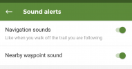
On the next display select Sound alerts.

Next push the slider for Navigation sounds to the right to turn the feature on.

Test by following a track for a bit and then turn off of it for awhile. You should get an audio warning. Head back to the track after you get the warning. You should get another audio signal that you are back on track.

Here's that final display:
Screenshot_20221010-120921.png

Here's Wikiloc's help page on Sound alerts:
 
I’ve moved several posts from a camino Olvidado thread over here.

And I wanted to add that there was an app change while I was walking. If you want to follow tracks off line, you have to make sure to save the track when you are on the internet, either with wifi or data. Once you save them they will be listed in your profile as “available offline” instead of the old title “saved trails.” I think this makes it less confusing.

So to use the app off line you need to save two vital components —the maps of the area where you will be walking (I have all of Spain and Portugal saved so I don’t need to worry about the map) and the tracks you want to have access to offline.
 
3rd Edition. More content, training & pack guides avoid common mistakes, bed bugs etc

Most read last week in this forum

Hi all! I know shoes are discussed quite a bit here but I have a last minute question as I head out on the Camino Frances next Sunday. I have a weaker ankle so I purchase the Oboz Sapphire Mid...
I stopped in the pilgrim store Armería Castro.Deportes y Tienda del peregrino today, and they carry bags of wool to use on your feet. https://maps.app.goo.gl/Zb8fM4AK2qyCuGYt6?g_st=ac
Anyone had any experience with getting collapsible (fold up) poles through airport security checkpoints in carryon baggage. In particular when exiting Australia and Spain?

❓How to ask a question

How to post a new question on the Camino Forum.

Similar threads

Forum Rules

Forum Rules

Camino Updates on YouTube

Camino Conversations

Most downloaded Resources

This site is run by Ivar at

in Santiago de Compostela.
This site participates in the Amazon Affiliate program, designed to provide a means for Ivar to earn fees by linking to Amazon
Official Camino Passport (Credential) | 2024 Camino Guides
Back
Top