• Get your Camino Frances Guidebook here.
  • For 2024 Pilgrims: €50,- donation = 1 year with no ads on the forum + 90% off any 2024 Guide. More here.
    (Discount code sent to you by Private Message after your donation)
  • ⚠️ Emergency contact in Spain - Dial 112 and AlertCops app. More on this here.

Search 69,459 Camino Questions

What mountains are near O Cebreiro ?

ilbestro12

Member
Time of past OR future Camino
Future
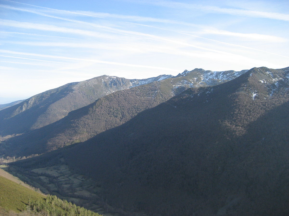
As you walk up that mountain range, are those mountains named ? I have heard O Courel, the Courel Mountains, Os Ancares, and the Iberian Massif for the greater area.

Can anyone provide some clarity for this part of the trail please ?
 
Solution
3rd Edition. More content, training & pack guides avoid common mistakes, bed bugs etc
O Cebreiro is nestled between the mountain ranges of O Courel and Os Ancares. Some lovely photos and info here:

That is where i got the initial info, but then i tried to find that Os Ancares mountain and it was listed more as a region. Maybe it is just a translation issue. Is it a plural series of mountains called Os Ancares
 
A selection of Camino Jewellery
Perhaps this link will help… as it provides an over-view of all the mountain ranges in Galicia, and if you look at the map, read the description of locations of the ranges, and plot for yourself where O’ Cebreiro is, then the “in between Ancares and Courel” will make perfect sense.
If you walk from Lugo, you will be on the ridge of the Ancares as you head down into Melide… If you walk on the Frances into and out of O’ Cebreiro, you are passing over/through the Courel range out of Castile-Leon.
 
That is where i got the initial info, but then i tried to find that Os Ancares mountain and it was listed more as a region. Maybe it is just a translation issue. Is it a plural series of mountains called Os Ancares
I think if you look carefully at what Theatregal posted (and you quoted) you'll notice that she said Os Ancares was a mountain range, rather than a single mountain. Bold added below:
O Cebreiro is nestled between the mountain ranges of O Courel and Os Ancares.
 
Perhaps this link will help… as it provides an over-view of all the mountain ranges in Galicia, and if you look at the map, read the description of locations of the ranges, and plot for yourself where O’ Cebreiro is, then the “in between Ancares and Courel” will make perfect sense.
If you walk from Lugo, you will be on the ridge of the Ancares as you head down into Melide… If you walk on the Frances into and out of O’ Cebreiro, you are passing over/through the Courel range out of Castile-Leon.
Very cool, thanks
 
Join our full-service guided tour of the Basque Country and let us pamper you!
I think if you look carefully at what Theatregal posted (and you quoted) you'll notice that she said Os Ancares was a mountain range, rather than a single mountain. Bold added below:
The wiki page listed it as a comarca, i think that is where i got confused. It must be a mountain range and an administrative district/region

 
The highest peak in Os Ancares is Cuiña peak (1992 mts) that is in Leon province. Mustallar (1983 mts) is the highest point in Lugo province. There are other peaks like Tres Bispos ( 1783 mts) in reference to bishops of Astorga, León and Lugo that used to meet there ( what is not true).
In O Courel the highest is Formigueiros (1643 mts). Here there is the biggest beech forest in Galicia. Galicia has very few beech trees.
All of them are easy to climb ( if you are in shape).
I don't know the meaning of Courel and Ancares but they have nothing to do with "mountain".
 
The first edition came out in 2003 and has become the go-to-guide for many pilgrims over the years. It is shipping with a Pilgrim Passport (Credential) from the cathedral in Santiago de Compostela.
As you walk up that mountain range, are those mountains named ?
Yes. You can find names for nearby peaks on Open Street Maps, here. You might need to adjust the scale of the displayed map to display the area you are most interested in and have the peak's names displayed. You might have to zoom in a fair bit to get some of the names displayed. There is one near O Cebreiro where the name didn't display for me until it was zoomed into a very small area around the peak.
 
Last edited:
St James' Way - Self-guided 4-7 day Walking Packages, Reading to Southampton, 110 kms
I climbed Cuiña, Mustallar, tres Bispos and Penarubia in Os Ancares but not from Pedrafita do Cebreiro. I did it from Refugio de Ancares and from Puerto de Ancares going there by car. Also climbed Formigueiros and Pia Paxaro in O Courel.
 

Most read last week in this forum

Zubiri was full early yesterday (by 2:30, according to some pilgrims who came to Pamplona today), but Zubiri opened up a municipal building just past the town for some pilgrims to sleep on the...
My friend is trying to figure out bookings/lodging. She started in SJPDP Friday, ended up walking the Winter route to Roncesvalles in one day, only to find no bed so bused back to SJPDP to sleep...
Hello everyone, This is a cry for help. I post this on behalf of my wife, who is walking the camino at the moment. Her backpack was taken away from the reception of the albergue Benedictina's...
Within the past few hours there have been two stories on local news media reporting that the Guardia Civil have been successful in returning lost passports to pilgrims. One in Najera, the other in...
The group running the albergue in the ruins of the San Anton monastery near Castrojeriz have announced that the albergue and the ruins will be closed from 1 May until the ruins have been made...

❓How to ask a question

How to post a new question on the Camino Forum.

Forum Rules

Forum Rules

Camino Updates on YouTube

Camino Conversations

Most downloaded Resources

This site is run by Ivar at

in Santiago de Compostela.
This site participates in the Amazon Affiliate program, designed to provide a means for Ivar to earn fees by linking to Amazon
Official Camino Passport (Credential) | 2024 Camino Guides
Back
Top