• Remove ads on the forum by becoming a donating member. More here.

Search 74,075 Camino Questions

Windy maps

ivar

Administrator
Staff member

Anyone tried this app?
 
Ideal sleeping bag liner whether we want to add a thermal plus to our bag, or if we want to use it alone to sleep in shelters or hostels. Thanks to its mummy shape, it adapts perfectly to our body.

€46,-
Get a spanish phone number with Airalo. eSim, so no physical SIM card. Easy to use app to add more funds if needed.

Anyone tried this app?
Trying to use it to familiarize myself. Shows well where wind direction is and temperatures but apart from that don’t know what to do with it.
 
Trying to use it to familiarize myself. Shows well where wind direction is and temperatures but apart from that don’t know what to do with it.
This is not the weather app (they also make a weather app) ... it is a map app where you can download offline maps and get walking directions... it has an elevation chart on the route you chose.. not sure if it is useful on the Camino, but it might be.
 
I had been using maps.me but windy was mentionned several times in the Via de la Plata forum and I have downloaded it but not really used it yet. (Maps.me proved great walking Via Francigena through France as downloadable) Am going to have a few trials with it over next couple of weeks
 
Perfect memento/gift in a presentation box. Engraving available, 25 character max.
I downloaded it after someone on the forum mentioned it as a good way to navigate the paths (not the road) to the lighthouse in Finisterre.
It worked well for that, but I haven't had a chance to use it otherwise.
 
Get a spanish phone number with Airalo. eSim, so no physical SIM card. Easy to use app to add more funds if needed.
I like it very much. A clear blue line shows the Camino overlaid on the map of Spain. I've used it this year on the Aragonés, the Castellano-Aragonés, the Ebro, the Plata, the Zamorano-Portugués and now on the Mozárabe and it's mostly very good on all of them.

I'd say it was better than most on some of the more obscure routes, but using the IGN and downloading onto maps.me etc works just as well, although windy's contour lines are much better than maps.me's. All have their pluses and minuses, and sometimes a combination needs to be used - windy did try to take me over a cliff in Portugal, but that was an exception.
 
Last edited:
Wow, no.
I've been raving here from time to time about the weather app, which is wonderful. So will be curious to see if the map app is as good.
 
The 2024 Camino guides will be coming out little by little. Here is a collection of the ones that are out so far.
I recently downloaded and setup Windy. My heretofore default weather app for Camino has been eltiempo.es+ This is the official app for the Spanish Meteorological Office.

My opinion is that Windy is a fabulous app, but has way too much and too scientific information for my likely usage on Camino. Windy has heaps of detailed maps, and charts that not only show the current conditions, and forecast, but also for very esoteric things. Wind shear charts, atmospheric pressure ridges, barometric pressures, real time radar and satellite images, nice, but IMHO overkill. If I was an airplane pilot, ship captain or perhaps a tour operator this additional information might have some practical value.

My needs on Camino are to know what the weather is now, and likely to be for the next 12 - 24 hours. Time of sunrise and sunset, percent likelihood of precipitation and what kind, wind strength and direction, and that is about it. I also just need the facts. All the graphics are, IMHO just too much.

This is why I plan to stick with eltiempo.es+. Both apps get the job done. Windy is very cool and feature-packed. It just, IMHO has too many features to be practical for me, on Camino.

The best metaphor I can come up with is carrying a Swiss Army Knife with maybe 6 tools, as opposed to carrying one with 36 tools. Weight aside, it is unlikely I will ever use 90 % of those tools on the über knife.

Eltiempo.es+ is adequate to task. Windy is (what we used to call Microsoft products) "bloatware."

Hope this helps.
 
I recently downloaded and setup Windy. My heretofore default weather app for Camino has been eltiempo.es+ This is the official app for the Spanish Meteorological Office.
T2, he's not talking about the weather app.
(And off topic, but some of us think windy is the bee's knees. I find it endlessly fascinating. And the more information the better - though in this case if you have some basic meteorology knowledge it does help. ;) )
 
Oops! I think I conflated Windy with Windy Maps. I had no idea there were TWO apps.

Nonetheless, I stand by my opinions about the Windy weather app and the eltiempo.es+

Your experience, like your Camino, including the apps you prefer are all highly personal. I respect all those differences of opinion.

Vive la difference!
 
Last edited:
Get a spanish phone number with Airalo. eSim, so no physical SIM card. Easy to use app to add more funds if needed.
This is not the weather app (they also make a weather app) ... it is a map app where you can download offline maps and get walking directions... it has an elevation chart on the route you chose.. not sure if it is useful on the Camino, but it might be.
Thanks for the clarification. I will look at it for sure then.
 
I have just played with it to check two local routes and the Baztan Camino. Looks great to this map reading challenged pilgrim! I will look later to see if it will pinpoint a favourite cafe along the Royal Canal way. Thanks for post, Ivar.
edit: yes, it does.
 
Last edited by a moderator:
I have just downloaded to an Android device, so not just for Apple now. Looks good at first glance, but I don't think it is as good as Viewranger yet, due to lack choice with mapping. It seems to be a single choice map. With VR I can download a few different types of map ( plus satellite views) and I can also choose to pay for top of the range maps or even just tiny portions (tiles) of said maps( IGN or OS for example).

Will play around with it for a few days and come back if I change my mind about it.
 
The 2024 Camino guides will be coming out little by little. Here is a collection of the ones that are out so far.

Anyone tried this app?
Yes Ivar, I use it a lot as it has the caminos already loaded for many routes.
Can also be used elsewhere.
Seasons Greetings
Regards
Mark
 
Yes Ivar i have used it on my last 2 camino's and now prefer it to my usual app...maps.me
By the way , i have an Android device ...Samsung , and it works fine .
 
Wow, no.
I've been raving here from time to time about the weather app, which is wonderful. So will be curious to see if the map app is as good.

Anyone tried this app?
i will be interested to read people’s experiences. Planning my first Camino next year and this could prove very useful.
 
The one from Galicia (the round) and the one from Castilla & Leon. Individually numbered and made by the same people that make the ones you see on your walk.
@ivar , thank you. I have been using the Android app +OSMAnd for about five years now and have got used to its way of doing things and coped with several upgrades. I have a three year old Samsung 10" tablet with keyboard.

I downloaded Windy Maps about 24 hours ago.

From looking at routes I know locally I see it takes it's data from Open Street Maps (OSM). All the local, regional and national routes I know of in my home 60 km square area were there and were named.

From my experience of using other map sources and apps, OSM is an excellent, if not the best, map data source.

No matter how good the map data source, presentation makes or breaks the experience.

To my mind the presentation of Windy Maps was cleaner than that offered by the app +OSMAnd.
And it also provided elevation contours (when , which +OSMAnd does not.

Windy Maps provides route planning and my simple experiments were well done. (But I will need more practice to best use this facility). A very nice feature was being able to show weather (temp, cloud/sun, rain) at the times expected to pass way points (Tom, please note 🙂). I noticed there were other route planning features and will look at these anon.

A nice feature in showing routes is this: When entering a route as base data in OSM you select the section of a path or road (or whatever) the route takes. In presentations I have see the route is overlaid on that path or road. In Windy Maps the route is show alongside. This means I can better see the basic nature of what I will be walking on. This can help with selection, for example, when sign posts are not present.

Of course elevation contours and routes show when zoomed in to a range of higher scales.

One awkward aspect of Windy Maps was this: I could not see the creation date for the map files I downloaded. So I don't know when to download a newer version. There may be a way to find this information that has eluded me.

I will continue to examine and will report any more significant aspects, as I find them.

Kia kaha katoa (you all take care, be strong, get going)
 
Last edited:
Used it on two 10 mile walks up the Northumberland Coast.

I won't be swapping my Viewranger app for this one. If I had never seen and used VR I may have been tempted. The choice of maps is too limited for me now. I use IGN when in Spain, I can use OSM if I want but I can also use satellite views as well. All downloadable for offline use. The interface with accommodation booking is a useful item, but you need to be online to use that and to be fair there are accommodation apps available for Camino routes with a much better coverage.

If you have never used a GPS app before, then this is, in my opinion, a good app to learn the basics with. Be aware that there are better apps (again personal opinion only) out there, some free, some not.
 
3rd Edition. More content, training & pack guides avoid common mistakes, bed bugs etc

Anyone tried this app?
I used it extensively when walking the Arles earlier this year. It was very good and I’d recommend it. However I ended up relying more on the GPS tracks I downloaded from Gronze.com into Gaia GPS (I used the free version and it was easy and spot on.)
 
Hy @All,

i use Mapy.cz since a Czech Girl recommended this app on the Portuguese from Lisbon. I really love it. Downloading offline maps it brings all the ways in the downloaded area automatically. The maps are really accurate and detailed. Every path in the middle of a forest is known, watering places, the shell stones, Albergues and more.

I don‘t like to search for gps tracks. The tracks i downloaded for maps.me led me here and there, as the creator walked here and there on a camino. Mapy.cz serves the exact Caminos without searching and downloading tracks first as they come with the map.

Fast, for free, offline navigation, detailled maps, voice navigation. I can really recommend mapy.cz.

Now to the question here: Mapy.cz (39 mb android) and Windy maps (60 mb android) are - i think - the same or almost the same app. I don‘t know the differences and the reason for the two apps. Same creator, Shaznam.cz.

Hope this can help (sorry for my poor english).

Love my mapy.cz!

So long
DonCamino

I used both Mapy.cz and Windy Maps and I believe they are from the same developer. For reasons I can’t recall anymore I ended up preferring Windy Maps. They both worked on my iPhone 8 with no problems.

Regarding downloaded GPS tracks the ones I downloaded from Gronze were right on the money. There was only one place on one stage where there was a slight difference in route which lasted about a quarter of a mile. Whoever recorded the tracks was very diligent in keeping to the route. 👍🏻
 
Ideal sleeping bag liner whether we want to add a thermal plus to our bag, or if we want to use it alone to sleep in shelters or hostels. Thanks to its mummy shape, it adapts perfectly to our body.

€46,-
I used it when we got off course on the Portugues route. You have to download the maps for the region you are interested in beforehand. A Spanish pilgrim told me about it as I was nearing Toro on the Levante.
I am seeing it will map out routes for hikes in my part of the US as well. I recommend it.
 
I didn't know that Gronze had GPS tracks.
Yes, they are really good. If you are using the English translation version via the Chrome browser, go to the Travel tab. If you are registered and logged in there will be a link just under the map displayed on that page. If you are in the Spanish version and registered and logged in they will be in the same spot on the Recorrido tab. Super easy to follow and super easy to download to Gaia GPS.
 
...and ship it to Santiago for storage. You pick it up once in Santiago. Service offered by Casa Ivar (we use DHL for transportation).
Yes, they are really good. If you are using the English translation version via the Chrome browser, go to the Travel tab. If you are registered and logged in there will be a link just under the map displayed on that page. If you are in the Spanish version and registered and logged in they will be in the same spot on the Recorrido tab. Super easy to follow and super easy to download to Gaia GPS.
Thanks, I found it. Do you have to download each stage individually?
 
Thanks, I found it. Do you have to download each stage individually?
Yes, that was my experience, one section at a time. I generally did two days out so I am guessing you could download all the stages (one at a time) in one sitting and have them all available in advance if you liked.
 
The one from Galicia (the round) and the one from Castilla & Leon. Individually numbered and made by the same people that make the ones you see on your walk.
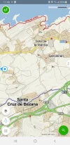
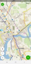
I thought that I would resurrect this thread to sing the praises of Windy Maps. It has just about every trail that you would want already built in, so you don't have to download additional tracks.

For example this coastal alternative out of Santander which you can see in red, while the regular Camino is dark blue.

Santander WIndy Maps smaller.webp

Or this screen shot of Vila do Conde in Portugal which shows both the coastal route and the connector between the coastal and the central routes (both in dark blue)

Vila do Conde Windy Map small.webp
 

Anyone tried this app?
I use it for weather in Canada but I can’t find where the maps section is in the app. Can anyone guide me please?
 
I use it for weather in Canada but I can’t find where the maps section is in the app. Can anyone guide me please?
It's a separate app

IPhone

Android
 
Ideal sleeping bag liner whether we want to add a thermal plus to our bag, or if we want to use it alone to sleep in shelters or hostels. Thanks to its mummy shape, it adapts perfectly to our body.

€46,-

Anyone tried this app?
I learned about it from a fellow peligrin on the Arles a few years ago and used it some. It’s a good tool. However, I found downloading tracks from Gronze was even better. Of course Windy Maps covers a lot of areas beyond the Caminos which Gronze does not.
 

❓How to ask a question

How to post a new question on the Camino Forum.

Most read last week in this forum

Anyone had ever encountered any trouble ot unjust behavior from Hospitaleros? If so, what was it and what to do??
I am not a fan of the Camino Francés, I have never walked it and most probabaly never will. (Please don't discuss the pros/cons of this route on this thread). However, despite my strong opinions...
I AM A PLANNER... I was 10 days in on my last camino before I was able to "relax" - that was when I finally had all of my nights booked. Please, do not make this a discussion about "to book or...
Not sure if this is appropriate use of the forum - but I just completed the Camino Frances last week (yay!!!) and bought a souvenir jet/silver ring for myself in Santiago, and the the jet stone...
My wife and I will finish our third camino next June in Santiago de Compostela. We will have approximately a week before we need to be in Lisbon. We are looking for advice for interesting places...

Featured threads

❓How to ask a question

How to post a new question on the Camino Forum.

Featured threads

Forum Rules

Forum Rules

Camino Updates on YouTube

Camino Conversations

Most downloaded Resources

This site is run by Ivar at

in Santiago de Compostela.
This site participates in the Amazon Affiliate program, designed to provide a means for Ivar to earn fees by linking to Amazon
Official Camino Passport (Credential) | 2024 Camino Guides
Back
Top