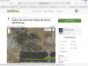
GOOGLE MAP OF A SAFE ROUTE OUT OF CÁCERES
I discovered this thread today and would like to refresh it because the issue is important and it seems like many forum members plan to walk VdlP in October or late September

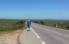
Walking the Camino out of Cáceres is on the side of a sometimes very busy road, particularly dangerous on weekday mornings, when it's raining, and if we walk before sunrise, which in October can be as late as half past 8 in the morning.
In this thread two alternatives have been given:
1. in the post #2 - a route starting soon after we pass the Bullring (Plaza de Toros). The alternative is about 1 km longer than the Camino and includes 80m/260ft ascent
2. in the post #24 - a route starting at the roundabout at the end of Caceres. It is also 1 km longer then the Camino, but incudes climbing a hill of Cerro Otero, which means ascent of 100m/330ft - I guess nice wievs from there
3. Not mentioned in the thread, a route which I actually took myself, when I decided that I will not walk one minute longer on this dangerous road. This route starts about 500 meters after I passed the roundabout so I walked maybe 6-7 minutes along the busy CC-38 road. This detour is slightly longer - 1,4 km - but the ascent is nicer, just 50m/130ft.
I placed all 3 alternatives on a google map, so anyone can download them as a kml file - to do that you touch or click the 3 dots next to the map title ("a safer route out of Caceres") and select : download KML from a pull down menu.
GOOGLE MAP : https://tinyurl.com/ExitCaceres
Myself, in a daylight and good weather, if necessary, I'm OK with walking on this road, but I wouldn't do it if I start early and it is still dark, or if I have walked already many km, and I'm too tired to pay close attention to the traffic. Half an hour of extra walking and a small hill to climb is a small price for avoiding an accident.
Have a Safe Camino!
View attachment 108463