- Time of past OR future Camino
- Francés, Norte, Salvador, Primitivo, Portuguese
Most people walk the road up to the lighthouse, but there are a couple of alternate approaches.
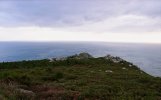
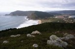
Firstly, there is a trail that you can take that brings you up over the top. You can find it on the Windy Maps app. It's the green line.
You can download Windy Maps for Android here, or for iPhone here.

This is the view that you get


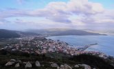
The 2nd approach doesn't take you directly to the lighthouse, but gives you a great view of it from the sea.
There are a couple of companies that do a sunset boat cruise, including this one. The boat takes you out by the lighthouse, and you have wonderful views. The 12 Euro price of the cruise includes a glass of wine or beer and a light snack.


Firstly, there is a trail that you can take that brings you up over the top. You can find it on the Windy Maps app. It's the green line.
You can download Windy Maps for Android here, or for iPhone here.
This is the view that you get
The 2nd approach doesn't take you directly to the lighthouse, but gives you a great view of it from the sea.
There are a couple of companies that do a sunset boat cruise, including this one. The boat takes you out by the lighthouse, and you have wonderful views. The 12 Euro price of the cruise includes a glass of wine or beer and a light snack.
Last edited: