• ⚠️ Emergency contact in Spain - Dial 112 and AlertCops app. More on this here.
  • Remove ads on the forum by becoming a donating member. More here.

Search 74,075 Camino Questions

Camino Marked from Vigo to Redondela?

Brian K

Member
Time of past OR future Camino
Camino Francis 2015, 2017, 2018 - Portuguese 2022
Hi,
We will be starting our Camino from Vigo and walking to Redondela on the first day. Does anyone have any information on how well the Camino is marked coming out of Vigo. I know from my experience on the Frances that it's quite easy to get lost on your way out of some of the bigger cities and end up walking longer than needed. I looked in the Brierly guide and he does have a map but it's not great. Does anyone have an an alternative map? Any help would be much appreciated! Thanks Brian
 
A selection of Camino Jewellery

Attachments

The 2024 Camino guides will be coming out little by little. Here is a collection of the ones that are out so far.
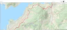
Just a heads up that at about 4 miles out there is a split in the road. You'll see yellow and green wavy lines. That is the Senda del Agua which takes you around the coast rather than over the top. It's the one I took and it was very pleasant forest route.

"Furthermore, it’s a trail with no steep areas, making it ideal for hiking with children in Vigo."

Map and KML route here


Attachments

  • Senda del Agua.webp
    Senda del Agua.webp
    190.2 KB · Views: 88
Last edited:
Just a heads up that at about 4 miles out there is a split in the road. You'll see yellow and green wavy lines. That is the Senda del Agua which takes you around the coast rather than over the top. It's the one I took and it was very pleasant forest route.

"Furthermore, it’s a trail with no steep areas, making it ideal for hiking with children in Vigo."

Map and KML route here

Appreciate it. Will definitely consider this option!
 
Another vote for the senda del agua. Its a lovely flat well marked route and was a relief to find after being fairly lost in Vigo itself.
 
Perfect memento/gift in a presentation box. Engraving available, 25 character max.
Just a heads up that at about 4 miles out there is a split in the road. You'll see yellow and green wavy lines. That is the Senda del Agua which takes you around the coast rather than over the top. It's the one I took and it was very pleasant forest route.

"Furthermore, it’s a trail with no steep areas, making it ideal for hiking with children in Vigo."

Map and KML route here

Yes indeed. The green waymarkers.
we did that trail in 2015. I wrote about it on this forum by then.
the hospitaleiro of the albergue in Nigran pointed us to this trail but did not know the name, Senda del Agua .we even hiked the trail which is marked on your added map , the thin dotted line , partly on the sandy beaches. Very nice
 
Last edited by a moderator:
Corned Beef or anyone else Is the Senda del Agua longer?
 
Get a spanish phone number with Airalo. eSim, so no physical SIM card. Easy to use app to add more funds if needed.
Yes www.caminador.es has excellent maps of all stages

It's fairly easy to leave Vigo. Head uphill from Calle Urzaiz and you will pick up yellow arrows. Or start from here..

Igrexa Parroquial da Inmaculada Concepción
Ursaiz is one of the two trainstations inVigo and connects Vigo with a.o. Redondela, Pontevedra,Padron and Santiago and even A Coruña and Ferrol
 
Last edited by a moderator:
A selection of Camino Jewellery
How far is it from Vigo to Redondela via the Senda del Agua route? Do you then recommend staying in Redondela? How far from Redondela to Pontevedra? Sounds beautiful and I would like to do it if I can manage the distances. Thanks
 
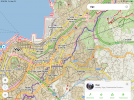
Just walked out of Vigo last April to Redondela with no difficulty at all. However, cities can be difficult in part because markers are not as readily seen due to all the distractors. Nonetheless, using the mobile app Mapy.cz made navigating the streets of Vigo very easy. As you’ll see in the example below, it’s as easy as just following the blue line out of town. With its gps program, you’ll see your location all the time.

AB3AA6A2-8939-4383-9154-0621703CF8ED.png

Our route from Vigo to Redondela was only about 16 kms. So a pretty easy walking day. Let me recommend staying at the Albergue A Casa da Herba right in the historical center of the city. Although we had a private double room there, pilgrims were not having any difficulty just showing up and getting a bed in the dormitory.

 
Last edited:

❓How to ask a question

How to post a new question on the Camino Forum.

Most read last week in this forum

Hi everyone! I am planning my first Camino Portuguese, starting in Porto in early April. It just so happens we arrive in Santiago on Easter weekend. I'm very much looking forward to seeing...

Featured threads

❓How to ask a question

How to post a new question on the Camino Forum.

Featured threads

Forum Rules

Forum Rules

Camino Updates on YouTube

Camino Conversations

Most downloaded Resources

This site is run by Ivar at

in Santiago de Compostela.
This site participates in the Amazon Affiliate program, designed to provide a means for Ivar to earn fees by linking to Amazon
Official Camino Passport (Credential) | 2024 Camino Guides
Back
Top