
bjorgts
Active Member
- Jan 2, 2006
- 375
- 608
- Time of past OR future Camino
- In Spain, France, Portugal, Germany since 2003
I said a couple of months ago that I should write something about the Levant-, Lana-, Sureste-routes, and then nobody heard anything from me. Sorry! One of the problems is that I do not know what should be written on the forums for the different routes. So now I post some here and some there on the three places.
In 2013 we walked 5 days on the Levante-route from Valencia to La Font de la Figuera in April. The weather was bad – rain and low temperature - and we had to go home for family reasons.
We returned in October, started out from Alicante on the Sureste-/Lana-route, and had 12 wonderful walking days to Las Pedroñeras. So then I know something about all three routes.
The Lana/Sureste from Alicante to Almansa (Sureste leave in Villena):
There are guides for these routes on internet. There are some local organisations which do a lot of good work connected to Sureste (and Lana, I think).
Already on our first day out of Alicante, we saw that this rout(s) was very well marked. My husbarnd said (before we actually got a bit lost!) that this was the best marked route in the whole Christianity. We found the walking out of Alicante nicer than the walk out of Valencia, but may be the weather influenced on our view. Stopped the first night in Monforte del Cid, and the second in Sax. If you long for a nice stay, Hotel Fuente del Cura in Sax is the place. It is the only hotel in town. Pilgrims are very welcome. And the two of us had a medi-pension for 60€. Nice landscapes and nice walk – also the next day when we went just 14 km to Villena. Several of these towns have fortresses.
From Villena to Almansa the route is changed. There are some alternatives, but we found out that the new main route seamed to go via Caudete. They have changed the route because of new roads, motorway and AVE crossing the old route. There was no problem finding our way. Very well marked.
All three routes:
Note! When you walk in this region, you must be aware of the fact that there are three Caminos going here and there, crossing each other, going together sometimes and then splitting up again. Sometimes the places where they split up are well marked, but not always. In Villena Sureste and Lana split up. This is very well marked in Villena. We followed the Lana-route.
The Lana from Villena to Almansa:
From Villena to Almansa the route is changed. There are some alternatives, but we found out that the new main route seamed to go via Caudete. They have changed the route because of new roads, motorway and AVE crossing the old route. There was no problem finding our way. Very well marked. Note that on Mundicamino the map show the old route Villena – Almansa via La Encina.
Lana: http://www.decuencaasantiago.org/rutalana/rutadelalana.php Here you can find an English version of this first etappas. It is a bit old, but can be used for some of the etapas. If you find old guides, the new Villena–Almansa-part are not there. May be this is a newer version of the same: http://caminodelalana.blogspot.no/p/recorrido-por-la-provincia-de-alicante.html I have not had time to see.
The next address is about for Villena – Caudete. There are some small pictures here that give you some maps with the chancing of the route. http://www.dealbaceteasantiago.es/CL_gVill-Alm.html
Caudete is a nice, small pueblo with a very nice albergue (Santa Ana). http://ermitasantaanacaudete.blogspot.no/ The local organisation take very well care of it. http://caminosantiagocaudete.blogspot.no/ Here is a Video from the “inauguracion” in 2912: http://www.youtube.com/watch?v=gghBgeeJR0w
Levante and Sureste:
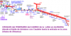
From Albacete to Minaya Levante and Sureste stay together. We were not aware of this. You should be!! They split up at the outskirt of the town! You come to Hostal Restaurante Antolin. On the left side there is a big yellow arrow on blue bottom. After a rest, we followed that arrow, but that was wrong. We hesitated, because on the map the camino passed the main road N-301 to the right, but we looked around there and saw no signs. So we thought that the route had been changed and followed the yellow arrow to the left… and went far away from where we should have been… following Camino Sureste… We stopped in a village and asked, but the people there did not know anything about different caminos. We headed for Casas de los Pinos far out of any map, and were lucky. We found it and had walked 38 km when we at last came to San Clemente.
We think that on many places Levante is not well enough signed. The parts where we went on both Sureste and Levante the route was very well signed. May be Sureste har active amigos keeping up the markings? May be The people who ones marked Levante is not active enough keeping up the marks? 6 km after San Clemente, the route turns left up to an abandoned house (well described here on the forum). We had the description, went up and down for several hundred meters looking for yellow arrows, but could not find any. So we followed some old arrows straight ahead (as the German guide said) and came to a main road. There a yellow arrow pointed straight ahead across the main road, but we could see from the guide that that was wrong. The guide told us to turn left and after some hundred meters, we turned right and were on the marked route again. Our conclusion are that Levante on some stretches has a problem with old marks fading away, while Sureste is well marked. That is not a good development for the beautiful San Clemente! Do not miss it!
Levante meet Sureste again I El Toboso, but we stopped in Las Pedrõners.
In 2013 we walked 5 days on the Levante-route from Valencia to La Font de la Figuera in April. The weather was bad – rain and low temperature - and we had to go home for family reasons.
We returned in October, started out from Alicante on the Sureste-/Lana-route, and had 12 wonderful walking days to Las Pedroñeras. So then I know something about all three routes.
The Lana/Sureste from Alicante to Almansa (Sureste leave in Villena):
There are guides for these routes on internet. There are some local organisations which do a lot of good work connected to Sureste (and Lana, I think).
Already on our first day out of Alicante, we saw that this rout(s) was very well marked. My husbarnd said (before we actually got a bit lost!) that this was the best marked route in the whole Christianity. We found the walking out of Alicante nicer than the walk out of Valencia, but may be the weather influenced on our view. Stopped the first night in Monforte del Cid, and the second in Sax. If you long for a nice stay, Hotel Fuente del Cura in Sax is the place. It is the only hotel in town. Pilgrims are very welcome. And the two of us had a medi-pension for 60€. Nice landscapes and nice walk – also the next day when we went just 14 km to Villena. Several of these towns have fortresses.
From Villena to Almansa the route is changed. There are some alternatives, but we found out that the new main route seamed to go via Caudete. They have changed the route because of new roads, motorway and AVE crossing the old route. There was no problem finding our way. Very well marked.
All three routes:
Note! When you walk in this region, you must be aware of the fact that there are three Caminos going here and there, crossing each other, going together sometimes and then splitting up again. Sometimes the places where they split up are well marked, but not always. In Villena Sureste and Lana split up. This is very well marked in Villena. We followed the Lana-route.
The Lana from Villena to Almansa:
From Villena to Almansa the route is changed. There are some alternatives, but we found out that the new main route seamed to go via Caudete. They have changed the route because of new roads, motorway and AVE crossing the old route. There was no problem finding our way. Very well marked. Note that on Mundicamino the map show the old route Villena – Almansa via La Encina.
Lana: http://www.decuencaasantiago.org/rutalana/rutadelalana.php Here you can find an English version of this first etappas. It is a bit old, but can be used for some of the etapas. If you find old guides, the new Villena–Almansa-part are not there. May be this is a newer version of the same: http://caminodelalana.blogspot.no/p/recorrido-por-la-provincia-de-alicante.html I have not had time to see.
The next address is about for Villena – Caudete. There are some small pictures here that give you some maps with the chancing of the route. http://www.dealbaceteasantiago.es/CL_gVill-Alm.html
Caudete is a nice, small pueblo with a very nice albergue (Santa Ana). http://ermitasantaanacaudete.blogspot.no/ The local organisation take very well care of it. http://caminosantiagocaudete.blogspot.no/ Here is a Video from the “inauguracion” in 2912: http://www.youtube.com/watch?v=gghBgeeJR0w
Levante and Sureste:
From Albacete to Minaya Levante and Sureste stay together. We were not aware of this. You should be!! They split up at the outskirt of the town! You come to Hostal Restaurante Antolin. On the left side there is a big yellow arrow on blue bottom. After a rest, we followed that arrow, but that was wrong. We hesitated, because on the map the camino passed the main road N-301 to the right, but we looked around there and saw no signs. So we thought that the route had been changed and followed the yellow arrow to the left… and went far away from where we should have been… following Camino Sureste… We stopped in a village and asked, but the people there did not know anything about different caminos. We headed for Casas de los Pinos far out of any map, and were lucky. We found it and had walked 38 km when we at last came to San Clemente.
We think that on many places Levante is not well enough signed. The parts where we went on both Sureste and Levante the route was very well signed. May be Sureste har active amigos keeping up the markings? May be The people who ones marked Levante is not active enough keeping up the marks? 6 km after San Clemente, the route turns left up to an abandoned house (well described here on the forum). We had the description, went up and down for several hundred meters looking for yellow arrows, but could not find any. So we followed some old arrows straight ahead (as the German guide said) and came to a main road. There a yellow arrow pointed straight ahead across the main road, but we could see from the guide that that was wrong. The guide told us to turn left and after some hundred meters, we turned right and were on the marked route again. Our conclusion are that Levante on some stretches has a problem with old marks fading away, while Sureste is well marked. That is not a good development for the beautiful San Clemente! Do not miss it!
Levante meet Sureste again I El Toboso, but we stopped in Las Pedrõners.
Attachments
Last edited:


