I am planning on walking the Littoral version of the Camino Portugese in September 2014 from Porto to Redondela where it joins the "main" branch of the Camino Portugese. The Baiona to Redondela sections of the Coastal and Littoral Caminos Portugese "braid" and criss-cross. Difficult to follow on any map. What is the quality of waymarking between these towns?
-
 ⚠️ Emergency contact in Spain - Dial 112 and AlertCops app. More on this here.
 -
Remove ads on the forum by becoming a donating member. More here.
Search 74,075 Camino Questions
You are using an out of date browser. It may not display this or other websites correctly.
You should upgrade or use an alternative browser.
You should upgrade or use an alternative browser.
Coastal/Littoral Camino Portugese Waymarking
- Thread starter grenking
- Start date
The one from Galicia (the round) and the one from Castilla & Leon. Individually numbered and made by the same people that make the ones you see on your walk.
frdaz
New Member
We did the coastal alternate route on our first day out of Porto. It meets up with the main route on day 3. I was glad we did it, as it goes right along the beach boardwalk and even onto the sand in a few spots, and it has some really nice scenery. The waymarking is not as good as on the main branch of the route. We actually got lost on the second day - probably due more to our inexperience than anything else, but I would do it again. In my opinion, it beats walking through the busy parts of Porto.I am planning on walking the Littoral version of the Camino Portugese in September 2014 from Porto to Redondela where it joins the "main" branch of the Camino Portugese. The Baiona to Redondela sections of the Coastal and Littoral Caminos Portugese "braid" and criss-cross. Difficult to follow on any map. What is the quality of waymarking between these towns?
haikutaxi
Member
- Time of past OR future Camino
- Camino Portugués (May 2012)
Coastal Camino Portugués (October 2013)
Camino Inglés (planning for ?)
I can't comment on that waymarking as we continued on to Vigo before heading to Redondela. We walked the coastal route this October, from Porto to Vigo (crossing the border by ferry from Caminha to A Guarda). From Vigo to Redondela we made a few wrong turns (and it was raining hard for the last hour of the walk), distance was about 10.5 miles. Give yourself a day off in Baiona (we did) ... it's a pretty town with lively street life and great inexpensive food. I'll be happy to share our itinerary if you like.
The focus is on reducing the risk of failure through being well prepared. 2nd ed.
fraluchi
RIP 2019
- Time of past OR future Camino
- One every year since 2007
Please do. With Annakappa we intend to walk the "Senda da orla litoral" from Porto right North (A Guarda, Oia, Baiona, Vigo) in June 2014 and would appreciate first hand info on where to walk, sleep, eat and visit "history". Thank you.[...]I'll be happy to share our itinerary if you like.
haikutaxi
Member
- Time of past OR future Camino
- Camino Portugués (May 2012)
Coastal Camino Portugués (October 2013)
Camino Inglés (planning for ?)
Please do. With Annakappa we intend to walk the "Senda da orla litoral" from Porto right North (A Guarda, Oia, Baiona, Vigo) in June 2014 and would appreciate first hand info on where to walk, sleep, eat and visit "history". Thank you.
Until I get my information typed in, make sure you check out this blog:
http://www.johnniewalker-santiago.blogspot.com/search/label/Camino Portugués Coastal route
Janna
New Member
I can't comment on that waymarking as we continued on to Vigo before heading to Redondela. We walked the coastal route this October, from Porto to Vigo (crossing the border by ferry from Caminha to A Guarda). From Vigo to Redondela we made a few wrong turns (and it was raining hard for the last hour of the walk), distance was about 10.5 miles. Give yourself a day off in Baiona (we did) ... it's a pretty town with lively street life and great inexpensive food. I'll be happy to share our itinerary if you like.
I am planning coastal Portuguese road this May 2014, your itinerary would be very helpful also for me.. is it still available? thank you very much!
...and ship it to Santiago for storage. You pick it up once in Santiago. Service offered by Casa Ivar (we use DHL for transportation).
Walker-Brother
New Member
- Time of past OR future Camino
- Portuguese Coastal Route Sept 2013
Camino Primitivo May 2017
Camino Sanabres June 2019
Did the coastal last September.
Baiona to Vigo waymarking is patchy got "lost" a couple of times and eventually just followed the main road into the City.
Vigo to Redondela is fine one you find the Rúa Urzaiz (it's at the side of the large Corte Ingles department store in the centre). Just keep heading up hill up there and you'll pick up arrows at the top (where it gets pedestrianised).
The Littoral is not marked at all at street level and the yellow arrows you follow are the coastal route (which confusingly is the one that is more inland). Not to be confused with the main inland route which you will pick up in Redondela.
Still got most of my trip notes and maps so give me a shout if you need any more details.
Last edited:
Mark Francis Auchincloss
The Auk
- Time of past OR future Camino
- From Braga to Santiago.
Yes waymarking is not good from Porto but it is getting better thanks to my mate Luis, see below. There are now sections like from Ramallosa to Balaidos in Vigo along the coast where green arrows are used to distinguish from official Coastal Route. Where the Coastal Route and Shoreline Route are separated the yellow arrow is generally used. I have just researched and written the shoreline route, as I call it, from Porto to Redondela which I can concur is incredibly beautiful. You follow the coast so it's nice and flat crossing beaches and dunes before catching the ferry from Caminha to enter the Galician border town and port of A Guarda continuing to follow the coat via Baiona, Oia,Nigran and Vigo until you get to Redondela where it meets the official route. Can't beat it for sheer outstanding beauty and easy on the legs not to mention the food and drink on the way!! Check out a summary of the details here http://caminoways.com/ways/portuguese-coastal-way-caminho-da-costa Will be uploading a video of the route in the next few weeks. I suggest you use my mate Luis Freixo's Blog, the leading authority on the route,as he has produced excellent, detailed maps in all formats see http://www.caminador.es/?page_id=117 These helped me alot on my camino, I downloaded the PDF files so I could use them offline while walking, that way it was impossible to get lost. Buen camino.
anniethenurse
Veteran Member
- Time of past OR future Camino
- Camino Frances.Vasco del Interior.Camino Finisterre& Muxia. Camino Portugues. Ruta del Ebro.
Hello there! I am walking the coastal Portuguese and it is very beautiful!
The first days out of Porto follow the coast line and the bicyclists mostly on the board walks.
Follow the yellow arrows when you see them. They will take you through farm land, eucalyptus and villages.
Albergues in Povoa, Marinhas, Fao, Viana do Castelo, Caminha.
And notice --- the ferry from Caminha, Portugal to A Guarda, Spain is not working this summer.
Means you have to take a taxi or walk another day.
I followed the coastal from Porto to Caminha to Valenca and to Tui.
Btw - In the evenings I looked for wifi and took screenshots of detailed google maps for the next day. A good map is goos to have.
Tonight in Pontevedra. The weather has been beautiful, no rain yet.
Buen Camino.
A selection of Camino Jewellery
dhansen1963
New Member
Did the coastal last September.
Baiona to Vigo waymarking is patchy got "lost" a couple of times and eventually just followed the main road into the City.
Vigo to Redondela is fine one you find the Rúa Urzaiz (it's at the side of the large Corte Ingles department store in the centre). Just keep heading up hill up there and you'll pick up arrows at the top (where it gets pedestrianised).
The Littoral is not marked at all at street level and the yellow arrows you follow are the coastal route (which confusingly is the one that is more inland). Not to be confused with the main inland route which you will pick up in Redondela.
Still got most of my trip notes and maps so give me a shout if you need any more details.
I am planning to walk this route with some friends next May. If you kept notes and don't mind sharing them, I would love details. We have discovered that finding details about this route has been somewhat frustrating. Many say they did the coastal route but headed inland much sooner than we are planning. We hope to go from Porto to Baiona before heading inland.
Donna
Get a spanish phone number with Airalo. eSim, so no physical SIM card. Easy to use app to add more funds if needed.
BCRockies
Member
- Time of past OR future Camino
- 2014 Late September
Caminho Portugues Coastal
can you send me a copy of the spreadsheet please?Have an accommodation Excel sheet,if you need it
€2,-/day will present your project to thousands of visitors each day. All interested in the Camino de Santiago.
F
Former member 22438
Guest
We are exploring the route now at this moment. staying at a campsite at Vila Praia de Âncora.Hello there! I am walking the coastal Portuguese and it is very beautiful!
The first days out of Porto follow the coast line and the bicyclists mostly on the board walks.
Follow the yellow arrows when you see them. They will take you through farm land, eucalyptus and villages.
Albergues in Povoa, Marinhas, Fao, Viana do Castelo, Caminha.
And notice --- the ferry from Caminha, Portugal to A Guarda, Spain is not working this summer.
Means you have to take a taxi or walk another day.
I followed the coastal from Porto to Caminha to Valenca and to Tui.
Btw - In the evenings I looked for wifi and took screenshots of detailed google maps for the next day. A good map is goos to have.
Tonight in Pontevedra. The weather has been beautiful, no rain yet.
Buen Camino.
Here in VilaPraia are lots of arrows. Today we went to Viana do Castelo and saw plenty of tiles with the shell.
One of the coming days we will go to Esposende and expect the same waymarking as where we now and as the first part from Porto, we walked last year.
We met some pilgrims in Viana do Costelo as well further down between Valença and Caminha .
The tourist office in Viana confirmed that the ferry between Caminha and Guarda is out of service because of mantainance.
It looks like a great walk and the aera we are now is beautiful.
We definitively will be back on the caminho Portuges next year after done the camino Ingles last week.
F
Former member 22438
Guest
Today we explored the route from Vila Praia de Âncora in Portugal to A Guarda in Spain.We are exploring the route now at this moment. staying at a campsite at Vila Praia de Âncora.
Here in VilaPraia are lots of arrows. Today we went to Viana do Castelo and saw plenty of tiles with the shell.
One of the coming days we will go to Esposende and expect the same waymarking as where we now and as the first part from Porto, we walked last year.
We met some pilgrims in Viana do Costelo as well further down between Valença and Caminha .
The tourist office in Viana confirmed that the ferry between Caminha and Guarda is out of service because of mantainance.
It looks like a great walk and the aera we are now is beautiful.
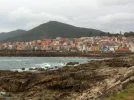
We definitively will be back on the caminho Portuges next year after done the camino Ingles last week.View attachment 10076
As mentioned the ferry between Caminha and A Guarda does not sail . We saw some pilgrims walking from Caminha via Vila Nova de Cerveira ,where is a bridge over the river Minho to A Guarda but as the kilometercounter of my car said , this is a detour of 24 kms. And you have to walk alongside a busy national road. if I had to walk now ,I should prefer to take a bus or a taxi
A Guarda is a nice place , we walked back from the center to the ferry , about 4 kms and vice versa. Nice walk. We saw some waymarks in the center.
We think we walk the caminho da Costa next year. It is beautiful so far
F
Former member 22438
Guest
We went to Caminha today. Very bad weather. Anyhow we saw some peregrinos.Today we explored the route from Vila Praia de Âncora in Portugal to A Guarda in Spain.
As mentioned the ferry between Caminha and A Guarda does not sail . We saw some pilgrims walking from Caminha via Vila Nova de Cerveira ,where is a bridge over the river Minho to A Guarda but as the kilometercounter of my car said , this is a detour of 24 kms. And you have to walk alongside a busy national road. if I had to walk now ,I should prefer to take a bus or a taxi
A Guarda is a nice place , we walked back from the center to the ferry , about 4 kms and vice versa. Nice walk. We saw some waymarks in the center.
We think we walk the caminho da Costa next year. It is beautiful so farView attachment 10104
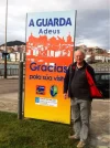
We went to the ferry see picture
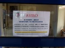
It says that the ferry is temporarely out of order and as soon as it available again the council of Caminha will anounce that.
Perfect memento/gift in a presentation box. Engraving available, 25 character max.
- Time of past OR future Camino
- 2012, 2013, 2014.
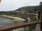
My wife and I drove this route in summer 2013 in our camper and only realised there was a coastal Camino when we saw the yellow arrows along the way. It is a very beautiful route. Oia was one of our favourite stops, we had a lovely afternoon there just near the monastery. This route is on my wish list. You can see the camper parked near it in the distance.

renaissancerebecca
New Member
- Time of past OR future Camino
- CF x 5
CPort x 2
ViaPod x2
CamInv x 1
Hospi x 4
Would love that spreadsheet if you have it. Thanks!Have an accommodation Excel sheet,if you need it
I am planning on walking the Littoral version of the Camino Portugese in September 2014 from Porto to Redondela where it joins the "main" branch of the Camino Portugese. The Baiona to Redondela sections of the Coastal and Littoral Caminos Portugese "braid" and criss-cross. Difficult to follow on any map. What is the quality of waymarking between these towns?
Hello grenking:
I, too, plan on walking the coastal camino in September. When do you start from Porto?
The 2024 Camino guides will be coming out little by little. Here is a collection of the ones that are out so far.
anniethenurse
Veteran Member
- Time of past OR future Camino
- Camino Frances.Vasco del Interior.Camino Finisterre& Muxia. Camino Portugues. Ruta del Ebro.
Welcome to the Forum, Shev!
I am planning to walk this route (again) in September - the 2 first weeks from Porto to Redondela and SDC. Maybe meet you there
I am planning to walk this route (again) in September - the 2 first weeks from Porto to Redondela and SDC. Maybe meet you there
Welcome to the Forum, Shev!
I am planning to walk this route (again) in September - the 2 first weeks from Porto to Redondela and SDC. Maybe meet you there
When do you start? I'm thinking of starting around September 4 or 5 from Porto.
Mark Francis Auchincloss
The Auk
- Time of past OR future Camino
- From Braga to Santiago.
You may like the video I did of shoreline camino from Porto to Santiago just so you can really look forward to it!
Perfect memento/gift in a presentation box. Engraving available, 25 character max.
freescot
Active Member
- Time of past OR future Camino
- La Plata (2010) Portuguese from Coimbra(2010) Levante (2011) La Lana (2013) Francés from Roncevalles to Molinasaca then the Camino de Invierno (2014)
http://www.johnniewalker-santiago.blogspot.com.es/search/label/Camino Portugués Coastal route
I couldn't agree more. I walked the route in February and Louis information was invaluable. Also, as another post suggests, http://www.johnniewalker-santiago.blogspot.com.es/search/label/Camino Portugués Coastal route is also very helpful.
Vigo is a bit of a challenge and what I didn't realise is that the yellow arrows mark the traditional route (i.e. since about 2010) while there are green arrows which take you to the albergue in Louis' village. Louis keeps these green arrows constantly updated. Louis wife speaks good English and the deviation away from the City is well worth it.
I've put here GPS maps for the route: http://www.the-raft-of-corks.com/blog/camino-to-santiago-from-oporto-by-the-coast-maps-and-gps/
and the blog itself, which is in production, slowly and is more personal than informative, although it has quite a few photos of a stormy February Camino, is here: http://www.the-raft-of-corks.com/blog/walking-water-portuguese-way-santiago-coast/ My nest post is probably about my visit to Vigo and my unforgettable meeting with Louis.
Yes waymarking is not good from Porto but it is getting better thanks to my mate Luis, see below. There are now sections like from Ramallosa to Balaidos in Vigo along the coast where green arrows are used to distinguish from official Coastal Route. Where the Coastal Route and Shoreline Route are separated the yellow arrow is generally used. I have just researched and written the shoreline route, as I call it, from Porto to Redondela which I can concur is incredibly beautiful. You follow the coast so it's nice and flat crossing beaches and dunes before catching the ferry from Caminha to enter the Galician border town and port of A Guarda continuing to follow the coat via Baiona, Oia,Nigran and Vigo until you get to Redondela where it meets the official route. Can't beat it for sheer outstanding beauty and easy on the legs not to mention the food and drink on the way!! Check out a summary of the details here http://caminoways.com/ways/portuguese-coastal-way-caminho-da-costa Will be uploading a video of the route in the next few weeks. I suggest you use my mate Luis Freixo's Blog, the leading authority on the route,as he has produced excellent, detailed maps in all formats see http://www.caminador.es/?page_id=117 These helped me a lot on my camino, I downloaded the PDF files so I could use them offline while walking, that way it was impossible to get lost. Buen camino.
I couldn't agree more. I walked the route in February and Louis information was invaluable. Also, as another post suggests, http://www.johnniewalker-santiago.blogspot.com.es/search/label/Camino Portugués Coastal route is also very helpful.
Vigo is a bit of a challenge and what I didn't realise is that the yellow arrows mark the traditional route (i.e. since about 2010) while there are green arrows which take you to the albergue in Louis' village. Louis keeps these green arrows constantly updated. Louis wife speaks good English and the deviation away from the City is well worth it.
I've put here GPS maps for the route: http://www.the-raft-of-corks.com/blog/camino-to-santiago-from-oporto-by-the-coast-maps-and-gps/
and the blog itself, which is in production, slowly and is more personal than informative, although it has quite a few photos of a stormy February Camino, is here: http://www.the-raft-of-corks.com/blog/walking-water-portuguese-way-santiago-coast/ My nest post is probably about my visit to Vigo and my unforgettable meeting with Louis.
F
Former member 22438
Guest
Nevertheless Vigo is a beautiful city with a lot of artfull sculptures, worth to be watched.http://www.johnniewalker-santiago.blogspot.com.es/search/label/Camino Portugués Coastal route
I couldn't agree more. I walked the route in February and Louis information was invaluable. Also, as another post suggests, http://www.johnniewalker-santiago.blogspot.com.es/search/label/Camino Portugués Coastal route is also very helpful.
Vigo is a bit of a challenge and what I didn't realise is that the yellow arrows mark the traditional route (i.e. since about 2010) while there are green arrows which take you to the albergue in Louis' village. Louis keeps these green arrows constantly updated. Louis wife speaks good English and the deviation away from the City is well worth it.
I've put here GPS maps for the route: http://www.the-raft-of-corks.com/blog/camino-to-santiago-from-oporto-by-the-coast-maps-and-gps/
and the blog itself, which is in production, slowly and is more personal than informative, although it has quite a few photos of a stormy February Camino, is here: http://www.the-raft-of-corks.com/blog/walking-water-portuguese-way-santiago-coast/ My nest post is probably about my visit to Vigo and my unforgettable meeting with Louis.
...and ship it to Santiago for storage. You pick it up once in Santiago. Service offered by Casa Ivar (we use DHL for transportation).
Mark Francis Auchincloss
The Auk
- Time of past OR future Camino
- From Braga to Santiago.
I trust the following article I just published with videos of each section helps too, should get you all excited! See link http://www.mydestination.com/galici...portuguese-coastal-way-from-porto-to-santiago
F
Former member 22438
Guest
Pagina web muy interessante. ¡ Gracias para compartirlo !I trust the following article I just published with videos of each section helps too, should get you all excited! See link http://www.mydestination.com/galici...portuguese-coastal-way-from-porto-to-santiago
Last edited by a moderator:
F
Former member 22438
Guest
Looking forward to come back to Vigo and all other beautiful Galician places next year when we will walk the caminho da Costa from Póvoa da Varzím !Pagina web muy interessante. ¡ Gracias para compartirlo !
We were once in Vigo ,now three years ago coming from Brasil with a cruiseship.
€2,-/day will present your project to thousands of visitors each day. All interested in the Camino de Santiago.
- Time of past OR future Camino
- 2012, 2013, 2014.
Thank you for sharing this, I have bookmarked it.I trust the following article I just published with videos of each section helps too, should get you all excited! See link http://www.mydestination.com/galici...portuguese-coastal-way-from-porto-to-santiago
Dirkhj
New Member
- Time of past OR future Camino
- Camino Frances May 2013
Camino Portugues May 2014
Camino Le Puy. May 2015
Hi
I did the same route you are planning to do a mounth ago. The costal section is fantastic, no busy roads or cars.
The waymarkings are not that bad. You have done it before, keep a lookout for them and you won't get lost.
Enjoy. Let me know if you need info.
Dirk
I did the same route you are planning to do a mounth ago. The costal section is fantastic, no busy roads or cars.
The waymarkings are not that bad. You have done it before, keep a lookout for them and you won't get lost.
Enjoy. Let me know if you need info.
Dirk
F
Former member 22438
Guest
Looking forward to this camiño.You may like the video I did of shoreline camino from Porto to Santiago just so you can really look forward to it!
Attachments
-
 ImageUploadedByCamino de Santiago Forum1404489171.466012.webp110.9 KB · Views: 33
 -
 ImageUploadedByCamino de Santiago Forum1404489196.412406.webp120.1 KB · Views: 31
 -
 ImageUploadedByCamino de Santiago Forum1404489257.899216.webp126.9 KB · Views: 30
 -
 ImageUploadedByCamino de Santiago Forum1404489279.203047.webp37.3 KB · Views: 30
 -
 ImageUploadedByCamino de Santiago Forum1404489346.253586.webp111.8 KB · Views: 29
Last edited by a moderator:
A selection of Camino Jewellery
Leaningforward
Active Member
Has anyone walked the coastal route in January or February? It's the easiest time for me to take time from work, and avoid walking temperatures over 65F/18C.
Leaningforward
Active Member
Has anyone walked the coastal route in January or February? It's the easiest time for me to take time from work, and avoid walking temperatures over 65F/18C.
D
Deleted member 3000
Guest
The focus is on reducing the risk of failure through being well prepared. 2nd ed.
F
Former member 22438
Guest
I don't think Porto will be the measure !
The weather more to the north is significantly more different (cooler and more rain) because of the presence of mountains. We found out ourselves last May and June. In Porto sunny. In Caminha and. A Guarda pouring with rain ,one time a whole week.
Last edited by a moderator:
Johan
Worcester, South Africa
- Time of past OR future Camino
- May 2013 : Leon to Santiago
May 2015 : Portugal
I can't comment on that waymarking as we continued on to Vigo before heading to Redondela. We walked the coastal route this October, from Porto to Vigo (crossing the border by ferry from Caminha to A Guarda). From Vigo to Redondela we made a few wrong turns (and it was raining hard for the last hour of the walk), distance was about 10.5 miles. Give yourself a day off in Baiona (we did) ... it's a pretty town with lively street life and great inexpensive food. I'll be happy to share our itinerary if you like.
I am planing on walking from Porto in May 2015. Please share your itinerary with me.
Thank you.
Regards,
Johan
Worcester, South Africa
BCRockies
Member
- Time of past OR future Camino
- 2014 Late September
Caminho Portugues Coastal
For those of you looking for detailed maps, almost step by step, from Porto to Redondela, I would like to give credit for this to the person who posted them before but I could not locate the original string where I found them. I believe he is from Portugal and probably very involved with this part of the Caminho. I printed them page by page and that may be a bit much but I can also open the files on DropBox the night before while on WIFI and then use them off-line on my Ipad while walking. I feel that it will save me some time as I do not plan to get lost anymore...
Attachments
-
CA01.SL-CC-PORTO-POVOA-2014-X2.pdf1.9 MB · Views: 124
-
CA02.GUIA-POVOA-MARINHAS-x-2.pdf1.6 MB · Views: 63
-
CA03.GUIA-ESPOSENDE-VIANA-x2.pdf1.3 MB · Views: 65
-
CA04.GUIA-VIANA-A-GUARDA-x-2.pdf1.6 MB · Views: 52
-
CA05.A-GUARDA-MOUGÁS-2014x2.pdf1.6 MB · Views: 56
-
CA06.MOUGÁS-A-RAMALLOSAx2.pdf1.2 MB · Views: 48
-
CA07.RAMALLOSA-REDONDELA-Guiax2.pdf1.8 MB · Views: 53
-
CA08.VIGO-PONTEVEDRA.Guiax2_.pdf1.3 MB · Views: 57
The 2024 Camino guides will be coming out little by little. Here is a collection of the ones that are out so far.
M
Meldelcamino
Guest
Mouth-wateringly motivating. A superb destination quite apart from the Caminho aspect.You may like the video I did of shoreline camino from Porto to Santiago just so you can really look forward to it!
F
Former member 22438
Guest
This is great information @BCRockies. Here I was waiting for. Many thanks for posting these pdf'sFor those of you looking for detailed maps, almost step by step, from Porto to Redondela, I would like to give credit for this to the person who posted them before but I could not locate the original string where I found them. I believe he is from Portugal and probably very involved with this part of the Caminho. I printed them page by page and that may be a bit much but I can also open the files on DropBox the night before while on WIFI and then use them off-line on my Ipad while walking. I feel that it will save me some time as I do not plan to get lost anymore...
We are intending to walk this part next year May.
Two months ago we were in the area and explored a part of it from Viana do Castela to A Guarda (by car).
Thanks again!
F
Former member 22438
Guest
Looking forward to start in Póvoa de Varzim next year May. Can't wait.Mouth-wateringly motivating. A superb destination quite apart from the Caminho aspect.
Thanks for sharing
The focus is on reducing the risk of failure through being well prepared. 2nd ed.
I'm a little lost. Based on many posts, I'm considering walking the coastal route out of Porto but I'd like to get back on to the main Portuguese route as soon as the dangerous road walking is minimized. Where is the best place to cross back over?
anniethenurse
Veteran Member
- Time of past OR future Camino
- Camino Frances.Vasco del Interior.Camino Finisterre& Muxia. Camino Portugues. Ruta del Ebro.
Walk from Vila do Conde to Sao Pedro de Rates on the central route.
About 45- 50 km if you start from the Cathedral in Porto and follow the coast line (Matosinhos, Vila do Conde, Rates) which is gorgeous.
That takes you out of Porto. But again I don´t know how the central route is from Rates because I haven´t walked it yet (I have walked the coastal only). Lots of road walking? Lots of traffic?
Regards,
Last edited:
F
Former member 22438
Guest
The central route goes from Porto to Vilarinho moreless direction airport We did not walk it either (we chose for the safe coastal detour ) but drove it by car and caravan last June and as many say walking this part is not nice, by car I must say it is quit challeging too.Walk from Vila do Conde to Sao Pedro de Rates on the central route.
About 45- 50 km if you start from the Cathedral in Porto and follow the coast line (Matosinhos, Vila do Conde, Rates) which is gorgeous.
That takes you out of Porto. But again I don´t know how the central route is from Rates because I haven´t walked it yet (I have walked the coastal only). Lots road walking? Lots of traffic?
Regards,
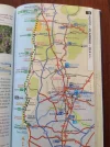
The detour via Matosinhos and the coastal to Vila do Conde and on to São Pedro de Rates is described in John Brierleys guide, camino Portuges.
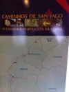
On the added picture the green dotted line is the detour, the yellowish dotted line is the central line
Last edited by a moderator:
The one from Galicia (the round) and the one from Castilla & Leon. Individually numbered and made by the same people that make the ones you see on your walk.
anniethenurse
Veteran Member
- Time of past OR future Camino
- Camino Frances.Vasco del Interior.Camino Finisterre& Muxia. Camino Portugues. Ruta del Ebro.
In Vila do Conde cross the river and turn immediately to the right if you want to walk to Rates.
To the left if you continue on the coastal
To the left if you continue on the coastal
haikutaxi
Member
- Time of past OR future Camino
- Camino Portugués (May 2012)
Coastal Camino Portugués (October 2013)
Camino Inglés (planning for ?)
JohnnieWalker has incorporated it in his excellent guide ... you can download or get in print.I am planning coastal Portuguese road this May 2014, your itinerary would be very helpful also for me.. is it still available? thank you very much!
The focus is on reducing the risk of failure through being well prepared. 2nd ed.
F
Former member 22438
Guest
Starting from Maia is okay you almost have passed the busy and dangerous part in the north of PortoHave enjoyed reading about the coastal route. My two fiends and I have opted this year for the inland from Maia. Leaving US Sept. 6. Maybe we will run into some of you coastal people . That may be my next route
You will enjoy the caminho
Do not forget to sleep at casa da Fernanda in
 Vitorino dos Piaës between Barcelos and Ponte de Lima.
The only place on the Porto to Santiago leg where you eat and drink all to gether with other pilgrims and the hospitaleros Fernanda and Jacinto are the kindest people who prepare you an unforgetable stay in their house.
Bom caminho
Walli Walker
Active Member
- Time of past OR future Camino
- Many. First 2009 and still going.
F
Former member 22438
Guest
@ Walli Walker. Welcome on this great forum.
Brierley only shows the coastal just out of Porto ,20kms to Vila do Conde and than turns inland to São Pedro de Rates.
As far as I know there must exist a booklet, thought it was issued by Johnnie Walker but still have to find it out for my walk along the coast but as long asyou will keep the ocean to your left you will walk northwards.
I only have some information from the internet about it, such as a link on this thread from some days ago.
Bom caminho
Albertinho
Get a spanish phone number with Airalo. eSim, so no physical SIM card. Easy to use app to add more funds if needed.
- Time of past OR future Camino
- Camino Primitivo Sept/Oct (2013) Fisterre-Muxia Oct 2013. Camino Ingles from Ferrol May 2014 and Santiago-Fisterre May 2014. Portuguese Coastal/Littoral (Sept. 2014)
Incredible info, thank you for reposting this. I hope to not get lost as well and this will definitely help. The PDFs are going to make it so much easier.For those of you looking for detailed maps, almost step by step, from Porto to Redondela, I would like to give credit for this to the person who posted them before but I could not locate the original string where I found them. I believe he is from Portugal and probably very involved with this part of the Caminho. I printed them page by page and that may be a bit much but I can also open the files on DropBox the night before while on WIFI and then use them off-line on my Ipad while walking. I feel that it will save me some time as I do not plan to get lost anymore...
Last edited:
F
Former member 22438
Guest
You won't get lost. Just follow the yellow waymarkers.Incredible info, thank you for reposting this. I hope to not get lost as well and this will definitely help. The PDFs are going to make it so much easier.
If you should get lost ask the locals "camino ? If you do not speak either Portugese or Spanish.
Buy the Brierley guide I should advise or Johnnie Walkers guide
Bom caminho
anniethenurse
Veteran Member
- Time of past OR future Camino
- Camino Frances.Vasco del Interior.Camino Finisterre& Muxia. Camino Portugues. Ruta del Ebro.
Hola Walli Walker,
Please send me a private message or e- mail for more info.
I WALKED the coastal / Littoral twice this year WALKING different options and stayed at several albergues and have talked to several other pilgrims who also WALKED the Camino Portugues coastal/ Littoral.
I am in Vigo today having WALKED today from A Ramallosa all the way on way marked path.
Tomorrow Redondela or Padron.
Bom Caminho
A selection of Camino Jewellery
F
Former member 22438
Guest
Annie. I am just being busy reading the maps and was wondering if you walk from Vigo to Redondela along the coast or you have to climb up to about 425 meters altitude more inland ?Hola Walli Walker,
Please send me a private message or e- mail for more info.
I WALKED the coastal / Littoral twice this year WALKING different options and stayed at several albergues and have talked to several other pilgrims who also WALKED the Camino Portugues coastal/ Littoral.
I am in Vigo today having WALKED today from A Ramallosa all the way on way marked path.
Tomorrow Redondela or Padron.
Bom Caminho
anniethenurse
Veteran Member
- Time of past OR future Camino
- Camino Frances.Vasco del Interior.Camino Finisterre& Muxia. Camino Portugues. Ruta del Ebro.
Hola,
I am following the yellow arrows tomorrow if I decide to walk from Vigo to Redondela. The yellow arrows do not follow the coast line. There is no way marking on the coast line from Vigo to Redondela as far as I know.
Following the yellow arrows the highest point is 150 m.
I am following the yellow arrows tomorrow if I decide to walk from Vigo to Redondela. The yellow arrows do not follow the coast line. There is no way marking on the coast line from Vigo to Redondela as far as I know.
Following the yellow arrows the highest point is 150 m.
Last edited:
anniethenurse
Veteran Member
- Time of past OR future Camino
- Camino Frances.Vasco del Interior.Camino Finisterre& Muxia. Camino Portugues. Ruta del Ebro.
There is also a way to walk from Moana to Pontevedra which I have not done yet.
A selection of Camino Jewellery
F
Former member 22438
Guest
Okay. I was just studying the maps I found on this thread and noticed a serious elevation and because you are around. Thanks and buen camino AnnieHola,
I am following the yellow arrows tomorrow if I decide to walk from Vigo to Redondela. The yellow arrows do not follow the coast line. There is no way marking on the coast line from Vigo to Redondela as far as I know.
Following the yellow arrows the highest point is 150 m.
Saludos deste lado del mundo
Albertinho
Linda Murphy
New Member
- Time of past OR future Camino
- Camino de Santiago-France (2012)
Yes, I would love your itinerary and also your thoughts about the weather in October.I can't comment on that waymarking as we continued on to Vigo before heading to Redondela. We walked the coastal route this October, from Porto to Vigo (crossing the border by ferry from Caminha to A Guarda). From Vigo to Redondela we made a few wrong turns (and it was raining hard for the last hour of the walk), distance was about 10.5 miles. Give yourself a day off in Baiona (we did) ... it's a pretty town with lively street life and great inexpensive food. I'll be happy to share our itinerary if you like.
Paddy Flannery
New Member
- Time of past OR future Camino
- Planning on May june 2017
This is the route my wife and i and 2 friends have decifed to walk in may june of next year year and would love any tips/ itinerary you could share.I can't comment on that waymarking as we continued on to Vigo before heading to Redondela. We walked the coastal route this October, from Porto to Vigo (crossing the border by ferry from Caminha to A Guarda). From Vigo to Redondela we made a few wrong turns (and it was raining hard for the last hour of the walk), distance was about 10.5 miles. Give yourself a day off in Baiona (we did) ... it's a pretty town with lively street life and great inexpensive food. I'll be happy to share our itinerary if you like.
The one from Galicia (the round) and the one from Castilla & Leon. Individually numbered and made by the same people that make the ones you see on your walk.
Kristone Capistrano
New Member
- Time of past OR future Camino
- Camino Ingles, Camino Frances-from Lourdes, Camino Portuguese-from Fatima, Kumano Kodo,
I can't comment on that waymarking as we continued on to Vigo before heading to Redondela. We walked the coastal route this October, from Porto to Vigo (crossing the border by ferry from Caminha to A Guarda). From Vigo to Redondela we made a few wrong turns (and it was raining hard for the last hour of the walk), distance was about 10.5 miles. Give yourself a day off in Baiona (we did) ... it's a pretty town with lively street life and great inexpensive food. I'll be happy to share our itinerary if you like.
Hi There would love to see your itinerary - currently deciding wether to walk the coastal route - but am a bit sacred of poor signage or cheaper accommodations. (were there much albergue on the route?)
Thanks
Kristone
Kristone Capistrano
New Member
- Time of past OR future Camino
- Camino Ingles, Camino Frances-from Lourdes, Camino Portuguese-from Fatima, Kumano Kodo,
Have an accommodation Excel sheet,if you need it
Hi there
Hola Walli Walker,
Please send me a private message or e- mail for more info.
I WALKED the coastal / Littoral twice this year WALKING different options and stayed at several albergues and have talked to several other pilgrims who also WALKED the Camino Portugues coastal/ Littoral.
I am in Vigo today having WALKED today from A Ramallosa all the way on way marked path.
Tomorrow Redondela or Padron.
Bom Caminho
Hi Annie,
Would love some info regarding the coastal route - my email is kristoneshotmail@gmail.com
Do you think it's possible to do it in 10 Days? I am an experienced walker and can do 40-50 kms if needed.
Thanks
F
Former member 22438
Guest
If you walk 40 or 50 kms a day you could do the coastal easy in 10 days.Hi there
Hi Annie,
Would love some info regarding the coastal route - my email is kristoneshotmail@gmail.com
Do you think it's possible to do it in 10 Days? I am an experienced walker and can do 40-50 kms if needed.
Thanks
Porto to Esposende day one
Esposendo to Caminha or A Guarda (depending on the timetable of the ferry and the tides)
A Guarda to Vigo day three
Vigo to Pontevedra day four
Pontevedra to Padrón day five
Padrón to Santiago day six
Keep the ocean at your left !
Ideal sleeping bag liner whether we want to add a thermal plus to our bag, or if we want to use it alone to sleep in shelters or hostels. Thanks to its mummy shape, it adapts perfectly to our body.
€46,-
€46,-
anniethenurse
Veteran Member
- Time of past OR future Camino
- Camino Frances.Vasco del Interior.Camino Finisterre& Muxia. Camino Portugues. Ruta del Ebro.
Hi there
Hi Annie,
Would love some info regarding the coastal route - my email is kristoneshotmail@gmail.com
Do you think it's possible to do it in 10 Days? I am an experienced walker and can do 40-50 kms if needed.
Thanks
Hola Kristone,
I will get back to you as soon as I can next week.
Kristone Capistrano
New Member
- Time of past OR future Camino
- Camino Ingles, Camino Frances-from Lourdes, Camino Portuguese-from Fatima, Kumano Kodo,
Thank YouHola Kristone,
I will get back to you as soon as I can next week.
Sheena
Active Member
- Time of past OR future Camino
- C de F (2015), P.Coastal (2016), CamIngles (2017), Senda Littoral (2018), CP Lisbon - Coimbra (2019)
For those of you looking for detailed maps, almost step by step, from Porto to Redondela, I would like to give credit for this to the person who posted them before but I could not locate the original string where I found them. I believe he is from Portugal and probably very involved with this part of the Caminho. I printed them page by page and that may be a bit much but I can also open the files on DropBox the night before while on WIFI and then use them off-line on my Ipad while walking. I feel that it will save me some time as I do not plan to get lost anymore...
I know it's a long time since you posted these wonderful maps, but the man who created them is Luis Freixo. Such attention to details, fabulous!
...and ship it to Santiago for storage. You pick it up once in Santiago. Service offered by Casa Ivar (we use DHL for transportation).
❓How to ask a question
How to post a new question on the Camino Forum.
Most read last week in this forum
Hi everyone!
I am planning my first Camino Portuguese, starting in Porto in early April. It just so happens we arrive in Santiago on Easter weekend. I'm very much looking forward to seeing...
Similar threads
- Replies
- 18
- Views
- 2K
- Replies
- 2
- Views
- 552
❓How to ask a question
How to post a new question on the Camino Forum.
Most downloaded Resources
-
“All” Albergues on the Camino Frances in one pdf“All” Albergues on the Camino Frances in one pdf
- ivar
- Updated:
-
A selection of favorite albergues on the Camino FrancésFavorite Albergues along the Camino Frances
- Ton van Tilburg
- Updated:
-
Profile maps of all 34 stages of the Camino FrancesProfile maps of all 34 stages of the Camino Frances
- ivar
- Updated:


